Why Kalamaloue National Park stands out
Kalamaloue is known for its combination of sahelian floodplain ecology and surprisingly easy wildlife observation within a very small protected footprint. Its location on the yaéré, the seasonal inundation zone of the Logone basin, gives it an unusually intense ecological character for its modest size, especially where permanent river water creates a swampy mangrove fringe of approximately three square kilometers. The park is also recognized for its role as a study site for human-wildlife interactions, particularly the way local communities use wild plants for food, medicine, and economic activities. Habituation of large mammals such as elephants to the presence of people, along with the park's accessibility from main roads, makes Kalamaloue a notable destination despite its limited size.
Kalamaloue National Park history and protected-area timeline
Kalamaloue National Park was created in 1972 as one of Cameroon's national protected areas. While it has long drawn scientific attention, it still lacked a sustainable management plan as of 2011, which has been a recurring concern for its long-term conservation.
Since the 1970s, the park has been used as a particularly effective field site for studying human-wildlife interactions. Researchers there have examined how surrounding communities interact with wild species through alimentation, traditional pharmacopoeia, and economic activities. This work has produced detailed inventories of edible and medicinal wild plants used by local ethnic groups such as the Mousgoum, Arabes Choa, Kotoko, and Bornoa.
The park's setting is also historically significant in a broader cultural sense. The town of Kousséri and its surroundings were once associated with the Sao civilization, a population of the Lower Chari region whose material culture, including terracotta anthropomorphic figures, has been recovered from archaeological contexts in the area.
Kalamaloue National Park landscape and geographic character
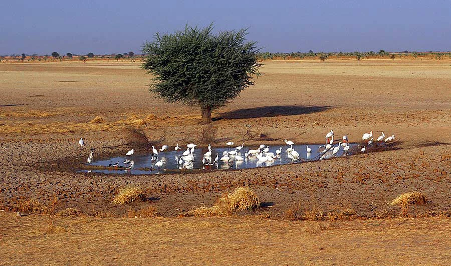
The landscape of Kalamaloue is defined less by elevation than by hydrology. The park lies on the yaéré, a vast plain of seasonal flooding within the Logone basin, where water levels and vegetation shift dramatically between the rainy and dry seasons. This flat, open terrain is the dominant visual signature of the reserve.
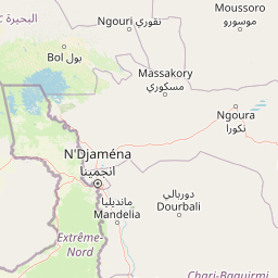
Permanent water is concentrated along the park's edges. The Logone and Chari rivers form a major riverscape on the northeast, while the Serbewel contributes a narrower, more seasonal watercourse to the north. Where these waters meet the floodplain, a swampy mangrove of about three square kilometers creates a denser, more shaded zone that contrasts sharply with the surrounding dry plains.
Open sahelian savanna and dry woodland round out the landscape. Acacias, mimosas, and other dry-adapted trees break up the grasslands, while along the Chari's banks taller species such as Anogeissus leiocarpus and the marula form semi-continuous bands of woody vegetation. The overall impression is of a flat, dry, river-influenced ecosystem where subtle shifts in water and soil support distinct habitat types within a very small area.
Kalamaloue National Park ecosystems, habitats, and plant life
Kalamaloue sits in a region where dry, semi-arid conditions and permanent river influence converge, producing a compact mosaic of habitats. The drylands support sahelian grasses, including Hyparrhenia and Loudetia simplex, while woody cover is dominated by species of the Capparaceae family, mimosas, and acacias. This vegetation structure is characteristic of the sudano-sahelian transition zone.
Where the rivers meet the floodplain, species composition shifts dramatically. The swampy mangrove fringe introduces evergreen and water-tolerant plants into an otherwise dry landscape, and the riverbanks support taller trees such as Anogeissus leiocarpus and marula (Sclerocarya birrea). These wetter patches function as ecological anchors, sustaining wildlife through the long dry season.
Overall, the park's ecological profile is shaped by seasonality. A long dry season and a brief irregular rainy season regulate plant productivity, flood levels, and animal movements, while the presence of permanent water ensures that some habitats remain relatively stable year-round.
Kalamaloue National Park wildlife and species highlights
Although the dedicated wildlife section of the source material is sparse, the larger biodiversity chapter describes a park where animals can be observed more easily than in many larger Cameroonian reserves, partly because of habituation to human presence. Elephants are regularly seen and, along with a variety of birdlife, are among the most visible forms of wildlife in the park.
Other mammals documented in or strongly associated with this habitat include giraffes, jackals (Canis aureus), patas monkeys (Erythrocebus patas), Grimm's duiker (Cephalophus grimmia), banded mongooses (Mungos mungo), and the bohor reedbuck (Redunca redunca). These species reflect a typical mix of savanna and dry woodland fauna adapted to sahelian conditions, with the wetter river margins adding habitat for water-associated mammals and birds.
The combination of floodplain, dry savanna, and river fringe makes Kalamaloue a worthwhile site for birdwatching and for observing large mammals in a compact setting, even if overall species richness is constrained by the park's small size and dry climate.
Kalamaloue National Park conservation status and protection priorities
Kalamaloue was established as a national park in 1972 and is officially classified under IUCN Category II, recognizing it as a protected area managed primarily for ecosystem protection. Its conservation value lies less in its size than in its ecological setting: it protects a representative sample of the yaéré floodplain ecosystem, including the swampy mangrove fringe along the Logone and Chari rivers.
A persistent conservation challenge has been the absence, noted in 2011, of a durable management plan for the park. This gap limits structured oversight of ecological pressures from grazing, agriculture, fishing, and human settlement in the surrounding region. Despite this, the park has continued to function as a refuge for wildlife and as a key site for studying human-wildlife interactions in sahelian Cameroon.
Its location along an international boundary, within an ecologically dynamic but fragile floodplain, also gives Kalamaloue significance beyond its borders, contributing to the broader conservation landscape of the Lake Chad basin and the Chari-Logone river system.
Kalamaloue National Park cultural meaning and human context
Kalamaloue National Park is embedded in a region of long-standing cultural diversity. The surrounding population includes Kotoko, Mousgoum, Arabes Choa, and Bornoa communities, along with smaller groups of Massa from the Mayo-Danay area and tribes originally from Chad. Each group contributes distinctive livelihoods: Kotoko are chiefly farmers and fishers, Arabes Choa focus on livestock and agriculture, and Mousgoum combine fishing with subsistence farming.
The local flora is woven deeply into daily life. Around 26 wild plant species have been documented in the park's surroundings as part of traditional food systems, contributing to roughly fifty distinct recipes. Among the Mousgoum alone, 21 edible species are used, while the Arabes Choa use about 20, the Kotoko 15, and the Bornoa 14. Notable species include Balanites aegyptiaca, Tamarindus indica, Boscia senegalensis (hanza), Diospyros mespiliformis, and Ziziphus mauritiana.
At a deeper historical layer, the wider Kousséri area is associated with the ancient Sao civilization. Terracotta artifacts attributed to the Sao have been recovered from the surroundings of Kousséri, hinting at a long human presence along the lower Chari that long predates the modern park boundary.
Top sights and standout views in Kalamaloue National Park
Kalamaloue's strongest distinctions are its compact size, its setting on the yaéré floodplain, and the unusually rich ecological gradients packed into just 45 square kilometers. The presence of a swampy mangrove along the Logone and Chari rivers, combined with surrounding sahelian savanna and woodland, creates a striking habitat mosaic for such a small reserve.
The park's accessibility, both from Kousséri and from the international road network, including the N1 that bisects it, also sets it apart. Combined with the habituation of its larger mammals, this makes Kalamaloue one of Cameroon's most approachable national parks for wildlife observation and ecological study, despite its modest scale.
Best time to visit Kalamaloue National Park
The climate of Kalamaloue is strongly seasonal, and the character of the landscape changes accordingly. From October through May, a long dry season dominates the park, with temperatures that often climb to extreme highs (commonly between 44°C and 45°C in peak months) and sparse vegetation cover. Wildlife tends to concentrate near the rivers and the swampy mangrove fringe during this period, which can make viewing somewhat easier if conditions are tolerable for visitors.
A short rainy season runs roughly from June to September, bringing irregular and generally modest precipitation, typically between 230 and 700 millimeters per year. This season transforms the yaéré floodplain, with greener vegetation, more active wildlife movement, and cooler temperatures, though humidity and flooding may complicate road travel in some areas.