

Mori Atlas logo
Wildlife reserveKanjli Wetland

Examining the ecological terrain and hydrological boundaries of this historic Punjab wetland

Kanjli Wetland Wildlife Reserve: An Atlas of Protected Landscape and Regional Geography

(Kanjli Wetland (Ramsar Site No. 1160))

Kanjli Wetland stands as a vital freshwater wildlife reserve within the agricultural plains of Punjab, India. This protected area represents a unique convergence of 19th century hydraulic engineering and contemporary conservation, encompassing a rich mosaic of open water, riparian woodland, and migratory bird habitats. Through our detailed atlas maps, examine the core lake boundaries, the Kali Bein River influence, and the surrounding irrigation-driven geography that sustains this Ramsar-recognized ecosystem.

freshwater wetlandRamsar siteman-made lakeirrigation reservoirbirdwatchingmigratory birds

Kanjli Wetland

Wildlife reserve

Park overview

Structured park overview, official facts, and landscape profile for Kanjli Wetland

Kanjli Wetland park facts, protected area profile, and essential visitor context

Review the core facts for Kanjli Wetland, including designation, size, terrain, visitor scale, habitats, and operating context in one park-focused overview.

About Kanjli Wetland

Kanjli Wetland is a Ramsar-listed freshwater wetland complex in the Kapurthala district of Punjab, northern India. It is built around the Kanjli Lake, a 184-hectare impoundment created in 1870 when Maharaja Randhir Singh of Kapurthala constructed headworks across the Kali Bein River. The irrigation infrastructure that gave rise to the lake transformed the surrounding floodplain into a fertile agricultural zone and at the same time established a permanent freshwater habitat that has since matured into a biodiversity-rich wetland. The broader wetland covers about 490 hectares and forms part of the Beas river basin, sitting upstream of the much larger Harike wetland, with which it shares ecological and hydrological characteristics.

The site's ecological profile is shaped by its semi-arid climatic setting, its agricultural catchment, and the hydrological influence of the Kali Bein. The river, which originally joined the Beas, now functions as an independent stream because of siltation and the westward swing of the Beas over time. Water levels in the lake fluctuate seasonally between roughly 3 and 7.6 meters, and the surrounding catchment is dominated by wheat, potatoes, and other crops that depend on the water supplied by the Bien. This intimate relationship between wetland hydrology and agrarian land use is one of the defining features of Kanjli.

Ecologically, Kanjli supports a layered habitat structure ranging from open water and aquatic vegetation through riparian and mesophytic zones to drier terrestrial margins. Twelve tree species, a range of shrubs and herbs, eleven aquatic plant species, and diverse planktonic and macro-invertebrate communities have been recorded. The wetland is regionally important for birds, with over forty resident species and sixteen migratory species documented, including waterfowl such as pochard, wigeon, tufted duck, common teal, pintail, mallard, and shoveller, as well as waders like the black-winged stilt, and a distinctive set of resident species that include the Indian spot-billed duck, Alexandrine parakeet, and white-browed wagtail. Mammals such as the Indian civet, mongoose, Indian porcupine, squirrel, and Indian hare are also part of the local fauna.

Despite its protected status, Kanjli faces ongoing ecological pressures. Extensive growth of water hyacinth, fueled by nutrients and pesticides from surrounding farmlands, has been a chronic problem, along with land encroachment, eutrophication from the decay of invasive plants, conversion of wetland margins for agriculture, habitation, and industry, and illegal fishing that disturbs waterbirds. In response, a range of conservation measures has been implemented, including manual and mechanical removal of hyacinth, the introduction of biological control agents, selective afforestation of islands and buffer zones with indigenous species, fencing of ecologically sensitive pockets, continuous water-quality monitoring, and public awareness programs coordinated by the Punjab State Council for Science and Technology under the Ministry of Environment and Forests.

Culturally, the wetland carries a layered identity. The Maharaja who created it built a French-style retreat, the Villa Buona Vista, on the lake's wooded banks, and his descendants continue to live there, lending the site an unusual combination of royal heritage, ecological significance, and contemporary recreational use that includes boating, fishing, and a traditional Diwali mela.

Quick facts and research context for Kanjli Wetland

Kanjli Wetland is located in Kapurthala district, Punjab, about 4 km from Kapurthala town. The wetland was created in 1870 by constructing headworks across the Kali Bein River, a former tributary of the Beas. It was designated a Ramsar Wetland of International Importance on 22 January 2002 (Site No. 1160). The wetland covers roughly 490 hectares, with the Kanjli Lake itself spreading about 184 hectares, and sits in a semi-arid zone receiving around 620 mm of annual rainfall. Lake depth varies seasonally from about 3.05 m to 7.62 m, and the surrounding catchment is dominated by agriculture.

Protection and recognition

Documented terrestrial designation history and management scope details

Kanjli Wetland Protection Status and International Recognition Data

Kanjli Wetland maintains a documented terrestrial protection status established in 2002 without transboundary records. Official designation history and management framework metrics provide verifiable context for conservation tracking.

Protection details

Protection scope
Terrestrial
Designated year
2002
Transboundary protection
No
Park context

Deeper park guide and search-rich context for Kanjli Wetland

Kanjli Wetland history, landscape, wildlife, and travel context

Explore Kanjli Wetland through its history, landscape character, ecosystems, wildlife, conservation priorities, cultural context, and seasonal travel timing in a structured park guide built for atlas discovery and search intent.

Why Kanjli Wetland stands out

Kanjli is best known as one of India's smaller but ecologically significant man-made wetlands, distinguished by its status as a Ramsar site, its royal 19th-century origins, and its combination of freshwater lake, agricultural catchment, and bird-rich habitat in the Beas river basin. It is recognized alongside the larger Harike and Ropar wetlands as one of three key Ramsar-listed wetlands of Punjab.
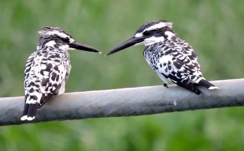
Pied Kingfisher at Kanjli Wetland
A pied kingfisher perched in the Kanjli Wetland in Punjab, India.

Kanjli Wetland history and protected-area timeline

Kanjli Wetland traces its origins to 1870, when Raja Randhir Singh, the Maharaja of Kapurthala, constructed headworks across the Kali Bein River to provide irrigation to the surrounding countryside. The creation of these headworks transformed a stretch of the river into the Kanjli Lake and laid the foundation for the broader wetland ecosystem that developed around it. The Maharaja also built a retreat called the Villa, or Villa Buona Vista, in the French architectural style, set among forested banks on the shores of the new lake; this estate remains in use by his successors and has become a distinctive element of the site's heritage character.

In the 20th century, growing awareness of the ecological value of man-made wetlands in India led to a national directory of wetlands prepared by an Expert Group set up by the Ministry of Environment and Forests in 1983 and published in 1990. Kanjli was among the man-made wetlands identified in that exercise. The lake already supported a documented aquatic and terrestrial flora and fauna, and on 22 January 2002 it was formally designated as a Ramsar Wetland of International Importance, becoming one of three Punjab wetlands, alongside Harike and Ropar, to be included in the international list.

Since Ramsar designation, Kanjli has been the focus of structured conservation and management planning under the Ministry of Environment and Forests, with on-the-ground implementation led by the Environment Division of the Punjab State Council for Science and Technology. Conservation measures over the past two decades have included wetland mapping toward protected-area notification under the Environment Protection Act, 1986, organized hyacinth control, biological control experiments, afforestation, fencing, water-quality monitoring, and public awareness initiatives.

Kanjli Wetland landscape and geographic character

Kanjli Wetland lies in the gently undulating agricultural plains of central Punjab, on the banks of the Kali Bein River about 4 km from Kapurthala town. The landscape is shaped by the contrast between open water and cultivated dryland, with the lake itself occupying a roughly 184-hectare water spread within a larger 490-hectare wetland envelope. Surrounding land is dominated by irrigated fields of wheat, potatoes, and other crops, interspersed with patches of woodland and small islands that have been subjects of targeted afforestation.

The terrain is largely flat to gently rolling, typical of Punjab's alluvial plains, and seasonal hydrology strongly defines the character of the site. During and after the monsoon, the lake expands and changes color as sediment loads shift; satellite imagery has shown low-turbidity conditions during the pre-monsoon period and moderate turbidity afterward. The lake bed itself varies between roughly 3 and 7.6 meters in depth depending on inflow and season, and average annual rainfall of around 620 mm sustains both the wetland and the agricultural catchment around it. The semi-arid climate, with hot summers, mild winters, and occasional freezing temperatures, gives the wetland an alternating rhythm of lush post-monsoon growth and leaner dry-season conditions.

Kanjli Wetland ecosystems, habitats, and plant life

Kanjli Wetland is an artificial freshwater wetland whose ecological value lies in the layering of habitats it sustains within a relatively confined area. Open water, fringing marshes, riparian vegetation, small wooded islands, and adjacent dryland agricultural margins together create a gradient from fully aquatic to terrestrial environments. The lake itself supports eleven recorded species of aquatic plants along with thirty-four zooplankton species and fifteen macro-invertebrate species, providing the base of a freshwater food web that extends to fish, birds, and mammals.

Around the lake, twelve species of trees have been documented, including Acacia arabica, Albizia lebbeck, Azadirachta indica, Dalbergia sissoo, Eucalyptus hybrids, Ficus bengalensis, Mangifera indica, Melia azedarach, Morus alba, Prosopis juliflora, Syzygium cumini, and Ziziphus mauritiana. Shrubs such as Calotropis procera, Ipomoea crassicaulis, and Tamarix dioca, as well as herbs like Saccharum spontaneum, Tripidium bengalense, and Scirpus species, complete a vegetated buffer between the open water and the agricultural lands beyond. This combination of aquatic, mesophytic, and terrestrial flora gives the wetland a multi-tiered plant community that supports a corresponding diversity of animal life.

Kanjli Wetland wildlife and species highlights

The wildlife of Kanjli is most notable for its birdlife, which is the principal reason for its Ramsar recognition. More than forty resident bird species and sixteen migratory species have been documented in and around the wetland. Migratory waterfowl recorded include various geese, white-eyed pochard, wigeon, tufted duck, common teal, large whistling teal, pintail, mallard, common shoveller, and others that use the lake as seasonal habitat. Wading species such as the black-winged stilt and a range of smaller migrants, including the white wagtail, citrine wagtail, red-breasted flycatcher, and common chiffchaff, are also recorded during passage and winter.

Resident birdlife adds year-round character to the site, with species such as the gray francolin, Indian spot-billed duck, Alexandrine parakeet, Indian thick-knee, white-browed wagtail, gray-throated martin, and red-naped ibis being part of the regular fauna. The pied kingfisher, frequently photographed at the lake, is one of the more conspicuous species for visitors.

Beyond birds, the wetland supports a typical suite of small mammals adapted to mosaic habitats, including the Indian civet, mongoose, Indian porcupine, squirrel, and Indian hare. The aquatic fauna is dominated by seventeen recorded fish species in the Kali Bein River and the lake, including Catla catla, Channa marulius, Cythus striatus, Cirrhinus mrigala, Labeo calbasu, and Labeo rohita, with the tortoise as the most commonly reported reptile in the area.

Kanjli Wetland conservation status and protection priorities

Kanjli's principal conservation significance lies in its international recognition as a Ramsar Wetland of International Importance, assigned to it in January 2002. This designation, together with its parallel listing alongside Harike and Ropar among Punjab's three priority wetlands, reflects the site's ecological importance within the Beas basin and beyond. It is one of the most prominent examples in India of a man-made wetland whose ecological functions, particularly for waterbirds, have developed alongside its original irrigation purpose.

Management of the wetland is guided by a state-level steering committee and implemented through the Environment Division of the Punjab State Council for Science and Technology, with support from the Ministry of Environment and Forests. Conservation measures include detailed mapping aimed at notification under the Environment Protection Act, 1986, organized hyacinth control using manual, mechanical, and biological methods (including experimental releases of Neochetina weevils and the potential introduction of the moth Sameodes albiguittal), selective introduction of additional fish species, afforestation of islands and buffer zones with indigenous trees, fencing of ecologically sensitive pockets to prevent grazing and encroachment, continuous water quality monitoring, public awareness campaigns, and continued research into biological, hydrological, and socio-economic aspects of the wetland.

The conservation perspective at Kanjli emphasizes maintenance of the wetland's filtering, flood-absorbing, and biodiversity functions while sustaining its role in agriculture, groundwater recharge, and local livelihoods.

Kanjli Wetland cultural meaning and human context

The cultural context of Kanjli Wetland is unusually rich for a small freshwater site. The wetland's very existence is tied to the 19th-century vision of Maharaja Randhir Singh of Kapurthala, whose engineering works on the Kali Bein created both the lake and the surrounding irrigation landscape. The French-style Villa Buona Vista, built by the Maharaja as a retreat on the wooded lakeshore, remains in private use by his successors and gives the site a distinctive royal and architectural character that blends European styling with a natural Indian setting. The lake is also a contemporary social space, hosting boating, fishing, and a traditional Diwali mela.

On a wider scale, the wetland is intimately linked to Sikh heritage through the Kali Bein River itself. Sikh tradition holds that Guru Nanak went missing for three days after bathing in the Kali Bein and re-emerged with the revelation that there is no Hindu and no Muslim, a moment regarded as the foundational moment of Sikhism. While the historical debate around this episode is recorded in only a few passages, the river's spiritual status adds a profound cultural layer to the wetland's identity, framing Kanjli not only as an ecological site but also as part of a landscape of deep regional meaning.

Top sights and standout views in Kanjli Wetland

Among the strongest distinguishing features of Kanjli Wetland are its status as one of the three Ramsar-listed wetlands of Punjab within the Beas basin, its 1870 origin as a royal irrigation project that matured into a biodiversity-rich freshwater habitat, and its exceptional diversity of birds, with over fifty resident and migratory species, including key waterfowl, waders, and kingfishers. The layered habitat of open water, riparian woodland, and small afforested islands, set within a working agricultural catchment, gives the wetland a uniquely combined ecological, cultural, and agricultural profile.

Best time to visit Kanjli Wetland

The character of Kanjli shifts notably with the seasons. Winter is the most rewarding period for birdwatching, when migratory waterfowl such as pochard, wigeon, tufted duck, pintail, mallard, and common teal arrive to join the resident birdlife, and when cooler temperatures make outdoor exploration of the lake and its surrounding woodland more comfortable. Post-monsoon months (after the rainy season has finished and water levels recede) tend to bring richer vegetation but also more turbid water, while the pre-monsoon dry period offers clearer water and lower lake levels that reveal more of the wetland's shoreline and islands. A traditional Diwali mela near the lake adds a cultural peak in the autumn festival season, making that period a particularly distinctive time to experience the site beyond its purely natural appeal.

Monthly climate preview

Long-term representative point measurements for temperature and monthly precipitation spread

Kanjli Wetland Climate Normals, Annual Temperature and Precipitation Rhythm

Kanjli Wetland records long-term average temperatures from twelve point-sampled months alongside measured precipitation shifts. Reviewing twelve-month climate normals provides deeper context for temperature ranges and monthly precipitation patterns across the protected landscape.
Annual mean25 °C
13 °C36 °C
Jan13°
Feb16°
Mar22°
Apr28°
May34°
Jun36°
Jul33°
Aug31°
Sep29°
Oct25°
Nov19°
Dec15°
Warmest month
June

35.7 °C

Coolest month
January

12.7 °C

Wettest month
August

6.3 mm/day

Driest month
November

0.2 mm/day

Park location guide

Geography guide, regional context, and park location map for Kanjli Wetland

Kanjli Wetland park geography, regions, and map view in India

Understand where Kanjli Wetland sits in India through a broader geographic reading of the surrounding landscape, nearby location context, and its mapped position within the national park landscape.

How Kanjli Wetland fits into India

India is a South Asian country bordered by the Indian Ocean, Arabian Sea, and Bay of Bengal. It shares land borders with Pakistan, China, Nepal, Bhutan, Bangladesh, and Myanmar. The country has a population of over 1.4 billion people and operates as a federal parliamentary republic with its capital in New Delhi.

Wider geography shaping Kanjli Wetland in India

India occupies the Indian subcontinent in South Asia, bordered by the Arabian Sea to the southwest, the Bay of Bengal to the southeast, and the Indian Ocean to the south. It shares land borders with Pakistan to the west, China, Nepal, and Bhutan to the north, and Bangladesh and Myanmar to the east. The territory also includes the Andaman and Nicobar Islands in the Indian Ocean.

Map view of Kanjli Wetland

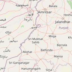
Use this park location map to pinpoint Kanjli Wetland in India, understand its exact geographic position, and read its mapped placement within the surrounding landscape more clearly.

Pigeon | © OpenStreetMap contributors

Location context for Kanjli Wetland

Punjab

Explore detailed park photography showcasing open water, seasonal hydrology, and wetland environments.

Kanjli Wetland Landscape and Scenery: Visualizing Protected Habitat and Terrain

Visual records capture the distinctive terrain, open water expanses, and riparian habitats that define Kanjli Wetland across changing seasonal cycles. Examining these protected area views helps researchers and visitors understand the ecological character of this Punjab river basin.

Pied Kingfisher at Kanjli Wetland

Park atlas

Compare regional wetlands, river basins, and surrounding conservation areas

Explore Parks Near Kanjli Wetland and Related Protected Landscapes

Browse other parks near Kanjli Wetland to examine connected river basins, agricultural catchments, and regional freshwater habitats. Comparing similar protected landscapes provides broader geographic context across the surrounding wetland network.
Wildlife reservePunjab
About 11 km away#1 closest

West

Beas Conservation Reserve: Geographic Atlas of a Punjab Protected Wildlife Landscape

Braided River Systems and Freshwater Biodiversity

Located in northwestern India, the Beas Conservation Reserve protects a vital 185 km river corridor. The reserve is characterized by a complex, shifting mosaic of sand bars and islands that support rare freshwater species. This entry provides detailed insight into the protected boundaries, hydrological features, and regional geography of this unique wetland conservation area in Punjab.

Established
2017
Relief
Lowland
Scope
Terrestrial
Water
Water-dominated
Protected areaHimachal Pradesh
About 95 km away#2 closest

Northeast

Pong Dam Lake Protected Area: Geography, Mapped Terrain, and Himachal Pradesh Wetlands

A vast reservoir bordering the Dhauladhar range

Pong Dam Lake is a sprawling reservoir in Himachal Pradesh that serves as a vital protected area for waterfowl and regional ecosystems. Its geography combines high-altitude dam engineering with the natural relief of the Siwalik foothills, offering a distinct landscape of seasonally shifting shorelines, forested ridges, and deep-water habitats that anchor the local environment.

Area
240 km²
Established
1975
Visitors
5K annual
Relief
Upland
Wildlife reservePunjab
About 95 km away#3 closest

East

Nangal Wildlife Sanctuary: A Protected Wetland Refuge in the Punjab Foothills

Mapped riparian landscapes and reservoir habitats in the Sutlej River basin

Located within the Shivalik foothills, Nangal Wildlife Sanctuary preserves a unique man-made reservoir ecosystem. This record details the park's protected boundaries, riparian vegetation, and its role as a essential wetland habitat for regional migratory waterbirds and threatened species in the Punjab river landscape.

Area
1.16 km²
Established
2009
IUCN
IV
Relief
Upland
Protected areaPunjab
About 116 km away#4 closest

East

Ropar Wetland: Geographic Mapping of a Punjab Freshwater Protected Landscape

Riverine and lacustrine geography in the Shivalik foothills.

Ropar Wetland stands as a significant protected area within the Punjab region, defined by its man-made reservoir origin and subsequent ecological maturation. This site serves as a vital transition point between the Shivalik hills and the Indo-Gangetic plains, hosting a dense variety of marshland, forest, and open water habitats that support rare reptile species and extensive bird populations.

Area
13.65 km²
Established
1952
Relief
Lowland
Climate
Subtropical
Wildlife reservePunjab
About 139 km away#5 closest

West

Changa Manga Wildlife Reserve: An Atlas of Punjab's Historic Man-Made Forest Landscape

Examining protected boundaries and plantation geography in the Punjab region

Changa Manga represents a unique intersection of industrial heritage and conservation, standing as one of the world's oldest and largest artificial forest plantations. Situated on the flat alluvial terrain of the Punjab, the reserve is defined by its regimented rows of sheesham and kikar trees. Beyond its historical roots as a fuel source, the area now functions as an essential wildlife refuge, maintaining critical habitats for endangered species and offering a look into the ongoing restoration of its protected boundaries.

Area
48.6 km²
Established
1866
Relief
Lowland
Climate
Subtropical
Wildlife reserveIndia
About 143 km away#6 closest

North

Surinsar-Mansar Lakes Wildlife Reserve: Protected Landscapes and Geography in India

Paired wetland ecosystems within the Jammu foothills.

Surinsar-Mansar Lakes, a designated wildlife reserve, provides a unique geographic study of paired wetland basins set in the low-lying hills of Jammu. This protected area supports a variety of migratory waterfowl and native turtle species within its forested borders, bridging the landscape between agricultural lowlands and the sub-Himalayan foothill environment.

Area
0.59 km²
Water
Water-dominated
Wildlife reserveSialkot District
About 160 km away#7 closest

Northwest

Bajwat Wildlife Sanctuary: Protected Riverine Terrain in the Sialkot District of Pakistan

Mapping riparian ecosystems along the Chenab River

Spanning approximately 5,400 hectares, Bajwat Wildlife Sanctuary provides a critical refuge for waterfowl and mammals within the densely populated Sialkot District. This protected area features a unique riverine mosaic of mudflats, open water, and floodplain forests that shift with the seasonal flows of the Chenab River and its tributaries, offering a distinct study in riparian conservation.

Area
54 km²
Relief
Lowland
Access
Access unknown
Scope
Terrestrial
National parkPakistan
About 190 km away#8 closest

Northwest

Deva Vatala National Park: Pakistan's Protected Tropical Thorn Forest Landscape

Explore mapped boundaries and regional geography within the Lower Himalayan foothills.

Deva Vatala National Park is a significant protected area located in Pakistan's Lower Himalayan Range, notable for its unique tropical thorn forest ecosystem. Occupying hilly terrain with elevations up to 1,101 meters, the park's landscape is defined by semiarid conditions and acacia-dominated vegetation, creating an unusual ecological interface. Its mapped boundaries encompass lake systems and diverse habitats, making it a critical conservation site within South Asia, distinct from typical Himalayan protected areas.

Area
70 km²
Established
1998
IUCN
II
Relief
Mountain

Common questions about visiting, size, designation, and location context for Kanjli Wetland

Kanjli Wetland FAQs for park facts, access, geography, and protected area context

Find quick answers about Kanjli Wetland, including protected-area facts, park geography, trail and visitor context, and how the park fits into its surrounding country and regional landscape.
MoriAtlas Explorer

Continue Your Protected Areas Search Across the Global Atlas

Deepen your exploration by continuing the structured search for national parks and protected areas worldwide. Utilize the comprehensive filtering capabilities to compare different conservation landscapes and refine your understanding of global park geography. Discover more about the distribution and characteristics of protected natural areas.

Global natural geography