Mori Atlas logo
Wildlife reserveNangal Wildlife Sanctuary

A vital protected reservoir and riverine ecosystem situated along the Sutlej River basin

Nangal Wildlife Sanctuary: Mapped Wetland Landscapes in the Shivalik Foothills of Punjab

Nangal Wildlife Sanctuary represents a distinct intersection of human-engineered water infrastructure and natural conservation in the Punjab region of India. Covering 116 hectares, this protected area spans the banks of the Sutlej River and functions as a critical wetland refuge within the Shivalik foothills. This atlas entry provides a detailed look at the sanctuary, mapping its reservoir-driven terrain, riparian corridors, and the ecological boundaries that support its diverse migratory bird populations.

wetlandRamsar sitewaterbird sanctuarySutlej Riverreservoir habitatShivalik foothills

Nangal Wildlife Sanctuary

Wildlife reserve

Park overview

Structured park overview, official facts, and landscape profile for Nangal Wildlife Sanctuary

Nangal Wildlife Sanctuary park facts, protected area profile, and essential visitor context

Review the core facts for Nangal Wildlife Sanctuary, including designation, size, terrain, visitor scale, habitats, and operating context in one park-focused overview.

About Nangal Wildlife Sanctuary

Nangal Wildlife Sanctuary is a compact but ecologically important protected area in northern India, set at the edge of the Shivalik Hills where Punjab meets the wider Indo-Gangetic plain. The sanctuary is built around a section of the Sutlej River reservoir created in 1961, and it functions primarily as a wetland reserve rather than a forest or highland park. Its character is shaped by water, by the surrounding dam infrastructure, and by its proximity to the town of Nangal in Rupnagar district.

In ecological terms, the sanctuary is a haven for freshwater biodiversity and a major stopover and wintering site for migratory waterbirds. The wetland supports more than 150 species of birds along with 35 species of fish and a variety of mammals, amphibians, and reptiles. Among its fauna, the Indian pangolin and the Egyptian vulture stand out for their conservation status, giving the site a role that extends beyond regional waterbird monitoring into broader species protection.

The sanctuary's Ramsar designation in 2019 placed it within the international network of important wetlands and reflected years of recognition for its birdlife and hydrological function. The reserve sits alongside the Nangal Dam, one of the landmark engineering projects of post-independence India and part of the larger Bhakra-Nangal system, which shapes both the physical landscape and the patterns of habitat use for the wildlife supported here.

For visitors, the sanctuary has become a focal point for birdwatching in Punjab, especially during the cooler months when migratory waterbirds arrive. At the same time, it remains a working conservation challenge: encroachment, pollution, habitat degradation, and limited public awareness all place pressure on the wetland's ecological health, making ongoing management central to its long-term future.

Quick facts and research context for Nangal Wildlife Sanctuary

Nangal Wildlife Sanctuary is a 116-hectare protected wetland reserve in Rupnagar district, Punjab, located along the Sutlej River near Nangal Dam. It was formally established as a wildlife sanctuary in 2009 and is administered by the Department of Forest and Wildlife of Punjab. The site is classified as an IUCN Category IV protected area, focused on habitat and species management rather than strict preservation.

The sanctuary sits within a larger man-made reservoir created in 1961 as part of the Bhakra-Nangal Project. It was designated a Ramsar wetland of international importance in 2019, highlighting its role as a refuge for migratory waterbirds and freshwater biodiversity in the Shivalik foothills.

Protection and recognition

Explore terrestrial protection metrics and official international Ramsar wetland records.

Nangal Wildlife Sanctuary Protection Status and Ramsar Recognition Data

Nangal Wildlife Sanctuary holds documented terrestrial protection status alongside verified Ramsar site recognition records. Detailed administrative and international conservation sources outline the scope of this protected natural area.

International recognition

Protection details

Protection scope
Terrestrial
Transboundary protection
No
Park context

Deeper park guide and search-rich context for Nangal Wildlife Sanctuary

Nangal Wildlife Sanctuary history, landscape, wildlife, and travel context

Explore Nangal Wildlife Sanctuary through its history, landscape character, ecosystems, wildlife, conservation priorities, cultural context, and seasonal travel timing in a structured park guide built for atlas discovery and search intent.

Why Nangal Wildlife Sanctuary stands out

Nangal Wildlife Sanctuary is best known as a waterbird sanctuary on the Sutlej River, supporting a rich community of resident and migratory birds within the Shivalik foothills. Although it is small in area compared with many Indian protected sites, its position on a major man-made reservoir gives it outsized importance for birdwatching and freshwater ecology. The sanctuary is also recognized for sustaining threatened species such as the Indian pangolin and the Egyptian vulture inside a small, human-adjacent landscape. Its combination of reservoir-fed habitat, riverine setting, and foothill location creates a distinctive ecological niche in Punjab's otherwise intensively used terrain.

Nangal Wildlife Sanctuary history and protected-area timeline

The hydrological foundation of Nangal Wildlife Sanctuary dates to 1961, when a section of the Sutlej River was impounded as part of the Bhakra-Nangal Project. This large-scale infrastructure initiative transformed the river into a reservoir and reshaped the surrounding Shivalik landscape, laying the groundwork for what would later become an ecologically significant wetland.

The area was formally granted protected status as a wildlife sanctuary in 2009, allowing the state forest and wildlife administration to manage the wetland for habitat and species conservation. The sanctuary's small footprint reflects a deliberate focus on the most ecologically valuable portion of the larger Nangal Wetland rather than an attempt to enclose the entire reservoir.

In 2019, the sanctuary was designated as a Ramsar site (Site No. 2407) under the international Ramsar Convention, formally recognizing its importance for migratory waterbirds and freshwater ecosystems. This international recognition coincided with growing concerns about encroachment, pollution, and habitat degradation within and around the sanctuary, which have shaped subsequent conservation discussions and recommendations from ecologists.

Nangal Wildlife Sanctuary landscape and geographic character

The landscape of Nangal Wildlife Sanctuary is defined by water and by the surrounding foothill country of the Shivalik Hills. The reserve occupies a portion of a man-made reservoir on the Sutlej River, bordered by low Shivalik ridges that descend toward the plains. The result is a transitional environment where reservoir shoreline, riparian vegetation, and the lower hill slopes come together in a relatively confined area.

The dam itself is a defining feature of the scenery. The Nangal Dam and its associated infrastructure sit adjacent to the sanctuary, giving the site a distinctive engineering-meets-ecology character. The reservoir creates the open water, shallow margins, and seasonal fluctuations that drive the wetland's ecological rhythms, while the nearby Shivalik slopes provide terrestrial context and additional habitat variety.

Throughout the sanctuary, the terrain is gently varied rather than dramatic. Wetland margins, reed beds, riparian growth, and pockets of scrubby vegetation border the water, and the wider horizon is dominated by the broad reservoir surface framed by the Shivalik foothills. The setting makes the reserve visually distinctive within Punjab, even though its scale is modest.

Nangal Wildlife Sanctuary ecosystems, habitats, and plant life

Nangal Wildlife Sanctuary is fundamentally a freshwater wetland reserve, with its ecological identity tied to the reservoir, the Sutlej River, and the surrounding Shivalik terrain. The wetland supports a layered ecosystem of open water, shoreline shallows, emergent vegetation, reed beds, and fringing terrestrial habitats, all compressed into about 116 hectares.

The refuge supports more than 150 bird species, around 35 fish species, and a broader community of mammals, amphibians, and reptiles. The mix of resident and migratory species allows the sanctuary to function as both a year-round habitat and a seasonal refuge, with winter migrants in particular reshaping the wetland's activity and ecological demands.

Because the reserve sits within a reservoir modified for hydropower and irrigation, the natural rhythms of the wetland are intertwined with human water management. Seasonal water levels, reservoir operations, and runoff from the wider catchment all influence habitat conditions inside the sanctuary, making the ecological story of Nangal one of a wetland that persists and thrives despite significant human influence.

Nangal Wildlife Sanctuary wildlife and species highlights

Wildlife is the centerpiece of Nangal Wildlife Sanctuary's identity, with birdlife driving both its protected status and its appeal. The sanctuary's 150-plus bird species include resident waterbirds, waders, and a significant influx of migratory species during the cooler months. The combination of open water, shallow margins, and adjacent scrub creates attractive feeding and roosting conditions for many waterbirds.

Among the more notable fauna, the Indian pangolin stands out as a threatened mammal whose presence underscores the sanctuary's role beyond waterbirds. Reptiles, amphibians, and mammals more broadly find habitat in the riparian and fringing vegetation around the reservoir, while the fish community anchors the aquatic food web.

The Egyptian vulture, recorded in the sanctuary, reinforces the site's broader conservation significance for raptors and scavenging birds, in addition to its waterbird profile. Together, this mix of species gives the sanctuary a wildlife character that is regionally important even if the area itself is small, and it makes Nangal a recognizable name among birdwatchers and freshwater ecologists in Punjab.

Nangal Wildlife Sanctuary conservation status and protection priorities

Nangal Wildlife Sanctuary plays an outsized conservation role for a site of its size, sitting at the intersection of local habitat protection and international wetland recognition. Its 2019 designation as a Ramsar site (Site No. 2407) confirmed its importance for migratory waterbirds and placed it within the global framework for wetland conservation.

The sanctuary is administered by the Department of Forest and Wildlife of Punjab and is classified as an IUCN Category IV protected area, emphasizing habitat and species management over strict wilderness preservation. This fits its setting: a working reservoir and dam landscape where the conservation goal is to maintain ecological function rather than to wall off a pristine environment.

At the same time, the sanctuary remains under pressure. Encroachment, pollution, habitat degradation, and limited public awareness all affect the wetland, and ecologists have called for stronger restoration and management to safeguard its bird and fish populations. The site's conservation narrative is therefore one of recognized value, active management, and ongoing vulnerability.

Nangal Wildlife Sanctuary cultural meaning and human context

Nangal Wildlife Sanctuary is closely tied to the modern engineering and development history of the region. The reservoir that defines the sanctuary was created in 1961 as part of the Bhakra-Nangal Project, a centerpiece of post-independence infrastructure in northern India. The town of Nangal itself grew around the dam and its associated industries, with the sanctuary now sitting immediately adjacent to both the dam and the urban area.

This setting gives the sanctuary a distinctive cultural footprint: it is a protected natural area embedded within a landscape shaped by water engineering, industrial development, and human settlement. Local communities have long interacted with the Sutlej and the reservoir, and the sanctuary's future is closely linked to how those relationships continue to evolve.

Top sights and standout views in Nangal Wildlife Sanctuary

Nangal Wildlife Sanctuary stands out for combining three qualities that are rarely found together: a Ramsar-recognized wetland, a major man-made reservoir, and a tight urban-forest interface on the edge of the Shivalik Hills. Within just 116 hectares, it supports 150-plus bird species, around 35 fish species, and threatened species such as the Indian pangolin and the Egyptian vulture.

The sanctuary's accessibility from the town of Nangal and its proximity to the Nangal Dam make it an unusual example of a small but internationally recognized wetland reserve in a heavily engineered river landscape. For birdwatchers, ecologists, and conservation planners, it offers a compact but rich case study in how biodiversity can persist alongside major water infrastructure.

Best time to visit Nangal Wildlife Sanctuary

The cooler months are widely regarded as the most rewarding time to experience Nangal Wildlife Sanctuary, when migratory waterbirds arrive from beyond the subcontinent and the reservoir margins fill with seasonal activity. Winter typically brings the richest birdwatching conditions, as cooler temperatures concentrate waterfowl, waders, and raptors around the open water and shallow zones of the wetland.

Outside of the winter season, the sanctuary retains year-round interest through its resident birds, fish, and other wildlife, but the density and variety of sightings are generally highest in the cooler half of the year. Visitors interested in migratory waterbirds and the fullest expression of the wetland's biodiversity will find winter the most rewarding window.

Monthly climate preview

Long-term temperature ranges and monthly precipitation patterns across representative coordinates

Nangal Wildlife Sanctuary Climate Normals and Annual Weather by Month

Representative coordinate records show measured monthly averages for temperature and precipitation spanning historical climate normals. Reviewing complete twelve-month profiles clarifies long-term meteorological trends across the protected terrain.
Annual mean24 °C
13 °C34 °C
Jan13°
Feb16°
Mar21°
Apr27°
May32°
Jun34°
Jul31°
Aug29°
Sep27°
Oct24°
Nov19°
Dec15°
Warmest month
June

33.9 °C

Coolest month
January

12.9 °C

Wettest month
August

8 mm/day

Driest month
November

0.3 mm/day

Park location guide

Geography guide, regional context, and park location map for Nangal Wildlife Sanctuary

Nangal Wildlife Sanctuary park geography, regions, and map view in India

Understand where Nangal Wildlife Sanctuary sits in India through a broader geographic reading of the surrounding landscape, nearby location context, and its mapped position within the national park landscape.

How Nangal Wildlife Sanctuary fits into India

India is a South Asian country bordered by the Indian Ocean, Arabian Sea, and Bay of Bengal. It shares land borders with Pakistan, China, Nepal, Bhutan, Bangladesh, and Myanmar. The country has a population of over 1.4 billion people and operates as a federal parliamentary republic with its capital in New Delhi.

Wider geography shaping Nangal Wildlife Sanctuary in India

India occupies the Indian subcontinent in South Asia, bordered by the Arabian Sea to the southwest, the Bay of Bengal to the southeast, and the Indian Ocean to the south. It shares land borders with Pakistan to the west, China, Nepal, and Bhutan to the north, and Bangladesh and Myanmar to the east. The territory also includes the Andaman and Nicobar Islands in the Indian Ocean.

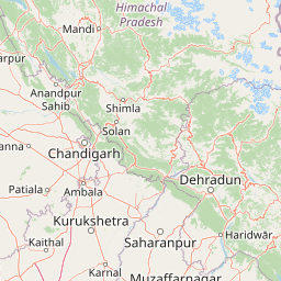
Map view of Nangal Wildlife Sanctuary

Use this park location map to pinpoint Nangal Wildlife Sanctuary in India, understand its exact geographic position, and read its mapped placement within the surrounding landscape more clearly.

Pigeon | © OpenStreetMap contributors

Location context for Nangal Wildlife Sanctuary

Punjab
Recorded earthquake history

Explore the Historical Earthquake Record for Nangal Wildlife Sanctuary

Review a detailed catalogue of recorded seismic events situated near the boundaries of Nangal Wildlife Sanctuary. MoriAtlas provides this data for historical mapping and geographic context, helping to visualize the distribution of recorded activity in the Shivalik foothills of Punjab.

Nangal Wildlife Sanctuary Earthquake History

Catalogued events

7 events

Strongest magnitude

Magnitude 4.7

Most recent event

Nov 6, 2013

This history includes earthquakes recorded inside the park or within 50 km of its borders

Park atlas

Compare adjacent wetland reserves, river habitats, and foothill landscapes across the region

Explore Parks Near Nangal Wildlife Sanctuary and Surrounding Protected Areas

Browse nearby national parks and protected areas connected to the Shivalik foothills and Sutlej River basin. Comparing adjacent wetland reserves and regional ecosystems reveals broader patterns in local conservation and wildlife distribution.
A horizontal watercolor painting depicting a meandering river passing through green wetlands and low-lying hills with a soft, misty background.
Protected areaPunjab
About 42 km away#1 closest

South

Ropar Wetland: Geographic Mapping of a Punjab Freshwater Protected Landscape

Riverine and lacustrine geography in the Shivalik foothills.

Ropar Wetland stands as a significant protected area within the Punjab region, defined by its man-made reservoir origin and subsequent ecological maturation. This site serves as a vital transition point between the Shivalik hills and the Indo-Gangetic plains, hosting a dense variety of marshland, forest, and open water habitats that support rare reptile species and extensive bird populations.

Area
13.65 km²
Established
1952
Relief
Lowland
Climate
Subtropical
A watercolor painting showing soft rolling hills and green pine trees against a light sky.
Protected areaHimachal Pradesh
About 73 km away#2 closest

North

Pong Dam Lake Protected Area: Geography, Mapped Terrain, and Himachal Pradesh Wetlands

A vast reservoir bordering the Dhauladhar range

Pong Dam Lake is a sprawling reservoir in Himachal Pradesh that serves as a vital protected area for waterfowl and regional ecosystems. Its geography combines high-altitude dam engineering with the natural relief of the Siwalik foothills, offering a distinct landscape of seasonally shifting shorelines, forested ridges, and deep-water habitats that anchor the local environment.

Area
240 km²
Established
1975
Visitors
5K annual
Relief
Upland
Wildlife reservePunjab
76 km away#3 closest

West

Beas Conservation Reserve: Geographic Atlas of a Punjab Protected Wildlife Landscape

Braided River Systems and Freshwater Biodiversity

Located in northwestern India, the Beas Conservation Reserve protects a vital 185 km river corridor. The reserve is characterized by a complex, shifting mosaic of sand bars and islands that support rare freshwater species. This entry provides detailed insight into the protected boundaries, hydrological features, and regional geography of this unique wetland conservation area in Punjab.

Established
2017
Relief
Lowland
Scope
Terrestrial
Water
Water-dominated
Wildlife reservePunjab
About 95 km away#4 closest

West

Kanjli Wetland Wildlife Reserve: Punjab Regional Geography and Protected Area Atlas

Hydrological boundaries and wetland ecosystems of central Punjab

Kanjli Wetland functions as a critical freshwater habitat and irrigation reservoir within the Punjab river basin. This protected area supports a diverse array of aquatic and terrestrial life, offering a unique window into the intersection of historical royal infrastructure and modern conservation efforts. Use this detailed geographic profile to understand the wetland's physical landscape, its role within the Beas basin, and its status as a key component of the regional protected network.

Area
4.9 km²
Established
1870
Relief
Lowland
Climate
Subtropical
National parkHimachal Pradesh
103 km away#5 closest

East

Great Himalayan National Park: Protected Landscape and Mapped Geography

Explore this national park's dramatic elevation and rich biodiversity.

Great Himalayan National Park is a vital protected area within India's Himachal Pradesh, celebrated for its exceptional biodiversity and dramatic mountain geography. This national park encompasses a remarkable range of elevations, creating distinct ecological zones from lower forest elevations to high alpine meadows and glacial zones. Its significance as a mapped protected landscape makes it essential for understanding regional natural heritage and conservation efforts within the Himalayas.

Area
1,171 km²
Established
1984
IUCN
II
Relief
Mountain
Watercolor illustration showing mountains, a tree, and a landscape with green and pink tones
National parkHimachal Pradesh
About 125 km away#6 closest

Northeast

Khirganga National Park: Himachal Pradesh National Park Geographic Atlas

Mapped protected area and regional landscape context.

Investigate Khirganga National Park, a designated national park situated within the vast mountain geography of Himachal Pradesh. This atlas-focused entry provides critical details on the park's protected landscape identity, its mapped boundaries, and its significance within the broader regional context of northern India's Western Himalayas. Understand the park's geographic position for detailed landscape exploration.

Area
710 km²
Established
2010
IUCN
II
Relief
Mountain
National parkIndia
About 134 km away#7 closest

Northeast

Inderkilla National Park: Detailed Protected Landscape and Geographic Atlas Entry

Mapping the natural terrain and protected boundaries across India.

Delve into the protected landscape of Inderkilla National Park, a designated national park located in India. This entry provides essential geographic context, focusing on the park's mapped boundaries and its role within the country's protected areas atlas. Understand the specific natural terrain and regional landscape character that defines Inderkilla National Park for detailed geographic exploration.

Area
46.1 km²
Established
2010
Relief
Mountain
Climate
Alpine
Watercolor painting of a lake surrounded by palms, reeds, and soft hills in the background.
Wildlife reserveHimachal Pradesh
About 135 km away#8 closest

Southeast

Renuka Sanctuary: Protected Wildlife Reserve and Ramsar Wetland Site in Himachal Pradesh

Ecological catchment and forest basin in the low Himalayan hills

Renuka Sanctuary is a dedicated wildlife reserve in Himachal Pradesh defined by the expansive Renuka Lake and its surrounding dry deciduous forest cover. This Ramsar wetland area protects the critical catchment zone of the state's largest natural lake, offering a unique intersection of conservation land and culturally significant natural terrain.

Area
4.028 km²
Water
Major water bodies

Common questions about visiting, size, designation, and location context for Nangal Wildlife Sanctuary

Nangal Wildlife Sanctuary FAQs for park facts, access, geography, and protected area context

Find quick answers about Nangal Wildlife Sanctuary, including protected-area facts, park geography, trail and visitor context, and how the park fits into its surrounding country and regional landscape.
MoriAtlas Explorer

Continue Your Protected Areas Search Across the Global Atlas

Deepen your exploration by continuing the structured search for national parks and protected areas worldwide. Utilize the comprehensive filtering capabilities to compare different conservation landscapes and refine your understanding of global park geography. Discover more about the distribution and characteristics of protected natural areas.

Global natural geography