
Mori Atlas logo
Nature reserveKannenbruch

Mapping the radial forestry lanes and waterlogged woodland ecosystems of a historic German natural reserve

Kannenbruch Nature Reserve: A Detailed Geographic Atlas of the Historic Bog-Forest Landscape in Schleswig-Holstein

(Naturwaldreservat Kannenbruch)

Kannenbruch is a 25-hectare natural forest reserve situated in the southwestern corner of Lübeck, Schleswig-Holstein. This protected landscape is defined by its poorly drained, swampy bog-forest terrain and a rare Biedermeier-era radial pattern of eleven clearance lanes centered on a historical rondel. Beyond its ecological value as a reference area for native spring flora and groundwater-dependent woodland species, the reserve serves as a compelling study of early 19th-century forestry planning and human-reshaped environments in Northern Germany.

natural forest reserveBiedermeier landscape designradial forest lanesbogie forestwet woodlandspring geophytes
A stylized vector illustration of a national park landscape featuring a waterfall in the distance, a winding river, a dense forest of evergreen and deciduous trees, and a wooden picnic table in the foreground.

Kannenbruch

Nature reserve

Park overview

Structured park overview, official facts, and landscape profile for Kannenbruch

Kannenbruch park facts, protected area profile, and essential visitor context

Review the core facts for Kannenbruch, including designation, size, terrain, visitor scale, habitats, and operating context in one park-focused overview.

About Kannenbruch

Kannenbruch is a small but carefully composed nature forest reserve in the southwestern outskirts of Lübeck. Although its modest size of around 25 hectares might suggest an ordinary patch of woodland, the site is in fact a designed landscape with deep historical roots. Its origin lies in the urban-rural reorganisation of the early 19th century, when the new macadam road between Lübeck and Hamburg sliced through the area and triggered a deliberate redistribution of woodland and farmland.

The guiding force behind the forest's design was Lübeck forest inspector Johann Georg Witthauer, who consolidated all woodland onto the western side of the new road and replanted several former agricultural plots, including Haukoppel, Dullrade, Spitzerienkoppel, and Nieland. Remnants of old hedgerow banks within the forest still attest to its earlier cultivation. The most visible expression of this planning is the radial Schneisen system, an eleven-spoke star of clearance lanes that fans out from a central rondel, echoing similar layouts in forest park Lustholz at Israelsdorf and recalling the geometric hunting-stars of Baroque landscape architecture.

Unlike Lustholz, however, the Kannenbruch star was never created for recreation. Witthauer considered the site too wet and cold for full high-forest use and instead managed it as a coppice-with-standards forest on a roughly 25-year cycle, subdividing the area into twenty-one units of about 6,3516 hectares each. The moister compartments were planted with softwoods, the drier ones with oak, while the central rondel was kept as a nursery area. A wide heath strip extending from the Bliestorf moor heath on the western edge and a boggy stretch along the former border with the Duchy of Lauenburg were also afforested as part of the same design.

In 1995, the city of Lübeck shifted its Stadtwald to near-natural forest management, and active forestry in Kannenbruch was suspended. The forest has since been left to develop as a Naturwaldreservat under the designation 01-088, making it a small but instructive example of how a culturally shaped European forest can gradually return to a more natural condition.

Quick facts and research context for Kannenbruch

Kannenbruch is a registered Naturwaldreservat (natural forest reserve, code 01-088) within the municipal forest of Lübeck, covering roughly 25 hectares in Schleswig-Holstein. The reserve stands on cold, low-gradient ground with elevated groundwater and surface water levels, lending it a swampy bog-forest character.

Its current form is the product of 19th-century land consolidation that accompanied construction of the Lübeck–Hamburg land road in 1828. The reserve is structured around a central rondel from which eleven radial forest lanes extend, dividing the forest into twenty-one working units. The forest hosts a species-rich spring flora, including several woodland plants that are otherwise rare in the Lübeck area.

Protection and recognition

Documented establishment chronology and international recognition records for Kannenbruch

Kannenbruch Protection Status and Designated Terrestrial Conservation History

Terrestrial protection metrics for Kannenbruch trace an established preservation history dating from 1995. Official designation records aggregate management scope and status data to provide an accurate baseline for conservation geography.

Protection details

Protection scope
Terrestrial
Designated year
1995
Transboundary protection
No
Park context

Deeper park guide and search-rich context for Kannenbruch

Kannenbruch history, landscape, wildlife, and travel context

Explore Kannenbruch through its history, landscape character, ecosystems, wildlife, conservation priorities, cultural context, and seasonal travel timing in a structured park guide built for atlas discovery and search intent.

Why Kannenbruch stands out

Kannenbruch is best known for its striking, eleven-rayed star of forestry lanes radiating from a central rondel, a distinctive geometric layout dating to the Biedermeier period. The reserve is also recognised for its unusually rich spring flora of geophytes, which thrives on its waterlogged, bog-forest soils, and for being a surviving example of an early planned municipal forest that has reverted to a strictly natural forest regime since 1995.
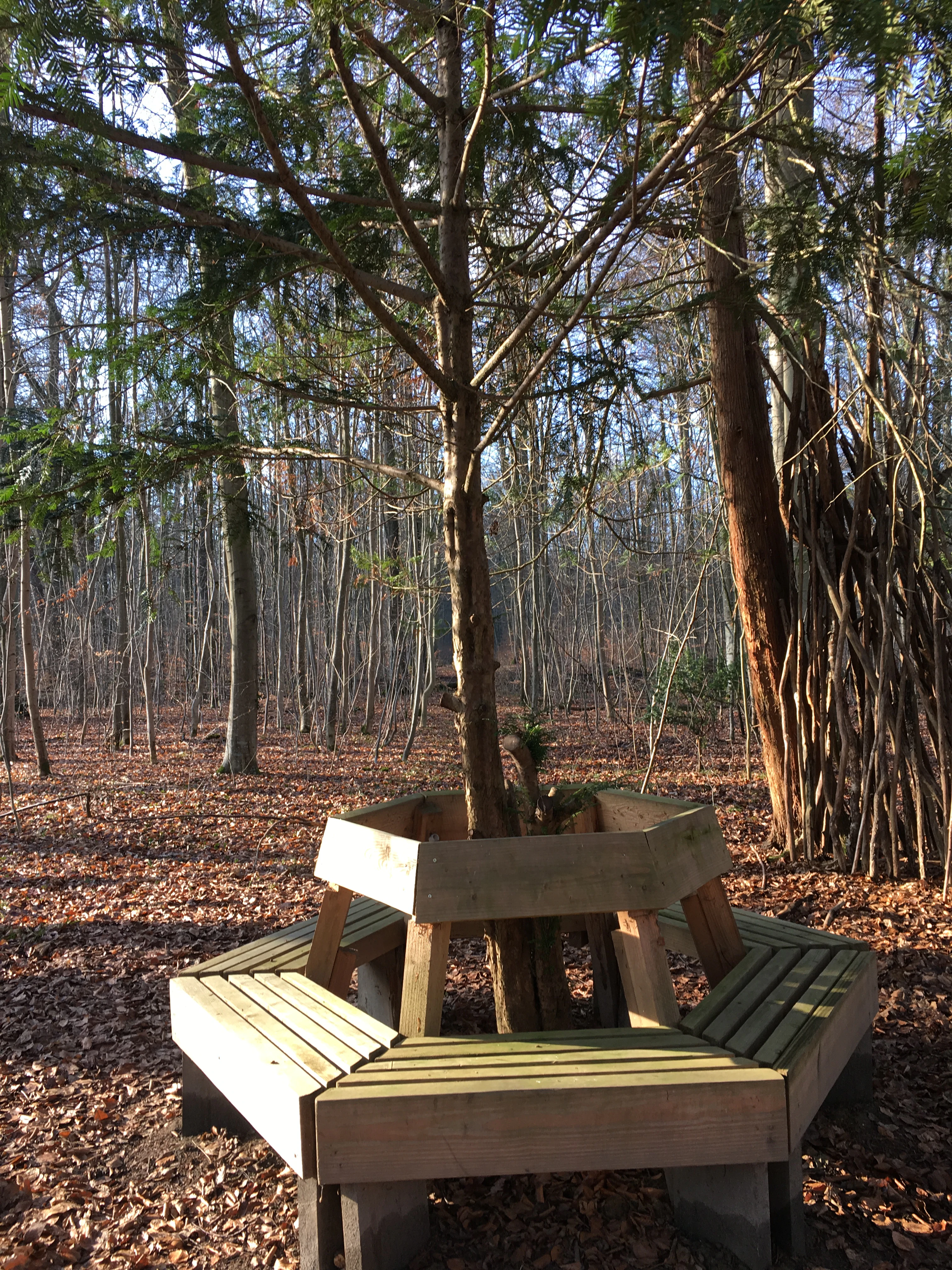
A hexagonal wooden bench surrounding the trunk of a coniferous tree in a deciduous forest, with fallen leaves covering the ground.
A wooden hexagonal bench built around a tree in the Kannenbruch nature reserve.

Kannenbruch history and protected-area timeline

The forest that now forms Kannenbruch is fundamentally a product of early 19th-century landscape and road planning. Its earliest phase dates to a period well before 1828, when only the southern third of the modern area was forested and the woodland extended further east toward the Krummesse estate. That pattern was permanently reshaped when a new macadam chaussée of the Lübeck–Hamburg land road was laid out in 1828, taking a straight course to bypass the steep descent into Krummesse and cutting the forest in two.

The construction of this road forced a wholesale re-parcelling of the surrounding land, and it was Lübeck forest inspector Johann Georg Witthauer who seized the opportunity to rationalise the municipal forest. He proposed concentrating all woods on the western side of the new road, leaving the eastern side to agriculture. Several former cropland plots, including Haukoppel, Dullrade, Spitzerienkoppel, and Nieland, were afforested as a result. The radial Schneisen star most likely took shape in the 1840s, dividing the usable forest into twenty-one working subunits, each of about 6,3516 hectares, with the rondel at its centre reserved for young-tree cultivation.

Kannenbruch's modern identity, however, was forged in the late 20th century. In 1995, the Lübeck city forest adopted a near-natural forestry concept, and Kannenbruch was withdrawn from active management and designated as a Naturwaldreservat under the official code 01-088. Since then the reserve has been allowed to develop without intervention, giving generations of visitors and researchers a chance to observe the slow ecological recovery of a culturally planned forest on marginal, waterlogged terrain.

Kannenbruch landscape and geographic character

Kannenbruch occupies a low, poorly draining position in the southwestern corner of the Lübeck city area, near the border with the former Duchy of Lauenburg. The terrain is essentially flat, with very limited slope, and the combination of heavy soils and minimal gradient keeps groundwater and stagnant surface water levels consistently high. This hydrology gives the reserve its characteristic swampy or bog-forest (Bruchwald) character and influences every other feature of the landscape.

The visible structure of the reserve is defined by its geometric forest plan. A central rondel forms the focal point of the site, and from it eleven broad clearance lanes radiate outward in a star pattern, slicing the woodland into regular wedge-shaped compartments. A separate area south of the main Große Allee contains four additional, slightly differently sized compartments, while a broad heath strip along the western edge opens onto what is essentially an extension of the Bliestorf moor heath. Beyond the forest itself lies the historic Kronsforder Hauptstraße, the modern L 92, the straight road that first triggered the entire reorganisation of the landscape in 1828.
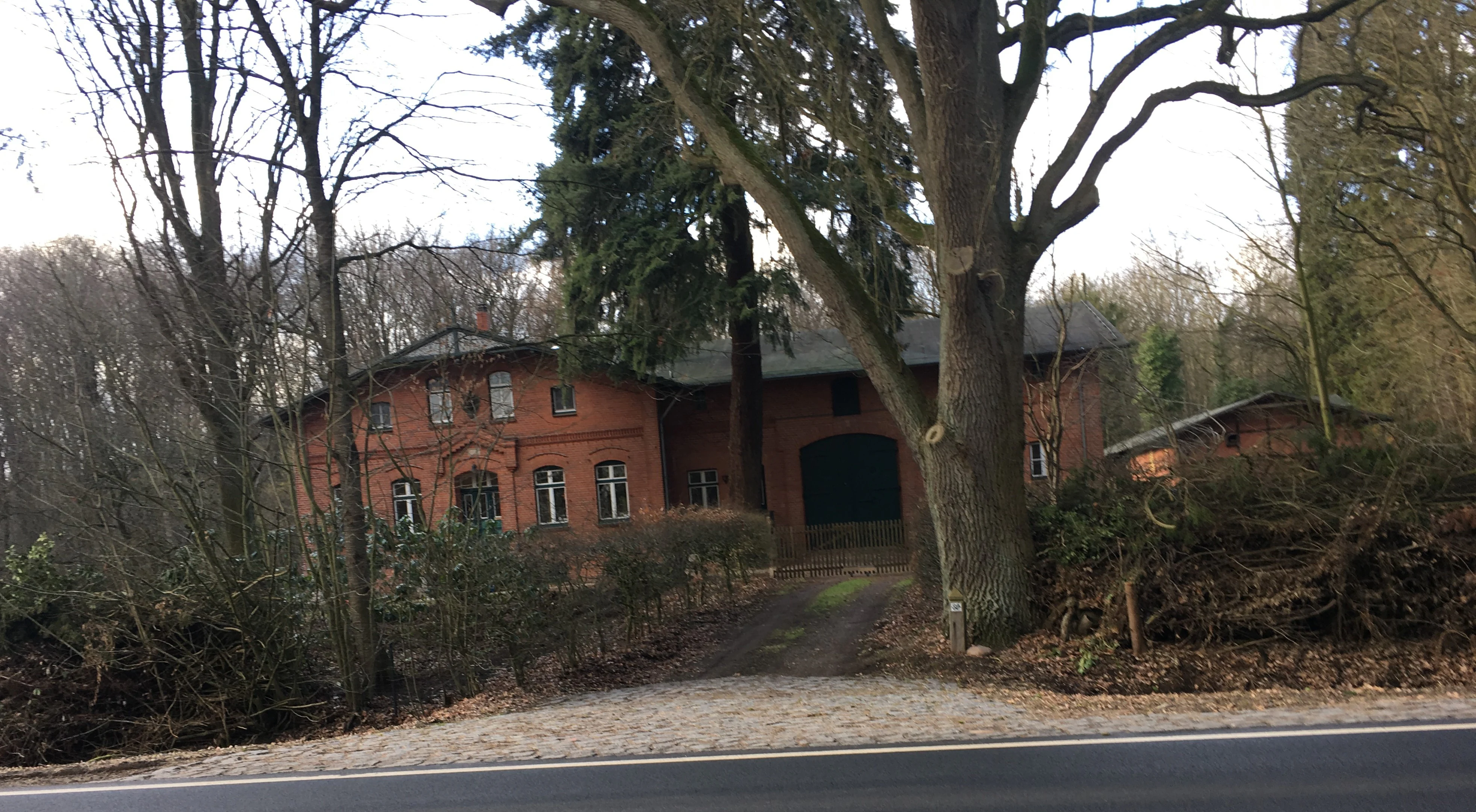
A red brick forestry building viewed from a roadside, framed by large deciduous trees and dense woodland.
The historic forestry office at Kannenbruch, a nature reserve in Schleswig-Holstein.

Kannenbruch ecosystems, habitats, and plant life

Ecologically, Kannenbruch is dominated by cold, waterlogged soils that support a distinctive bogwood-style forest community. The tree cover reflects the original 19th-century plantings, with beech, pine, and spruce as the dominant species, supplemented by a historical linden at the heart of the rondel. Around the central clearing, the original planholders introduced several exotic species, including American oaks, a plane tree, acacias, and Douglas firs, some of which still survive as individual mature trees.

The most striking ecological feature of the reserve is its unusually species-rich spring flora. Because the canopy has not yet closed when many of the woodland flowers emerge, a wide range of spring geophytes thrives here, including primroses, wood anemones, corydalis, and golden stars (Goldstern). In June, the forest floor supports wood lady's smock (Waldschaumkraut), a species that is otherwise uncommon in the Lübeck area, and visitors can also encounter the heath-spotted orchid (Geflecktes Knabenkraut) within the reserve. Since active forestry was halted in 1995, the forest has been left to regenerate more naturally, offering a small, controlled setting for observing how humandominated woodlands evolve when withdrawn from management.

Kannenbruch wildlife and species highlights

The available source material does not describe distinctive fauna populations, breeding bird communities, or specific mammal or insect species associated with Kannenbruch. The reserve's wildlife profile is best understood through its habitat rather than through any catalogued animal species, and without additional supporting information the wildlife cannot be meaningfully expanded here.

Kannenbruch conservation status and protection priorities

Kannenbruch's principal conservation role is its status as a registered Naturwaldreservat, designated 01-088 in the federal natural forest inventory following Lübeck's 1995 decision to shift the city forest to near-natural management. By suspending active forestry on the site, the city created a small but well-defined reference area where a culturally shaped, formerly coppice-managed forest on hydrologically marginal land can develop toward a more natural forest state.

The reserve's boggy soils and spring flora give it additional conservation value. The presence of woodland species that are otherwise rare in the Lübeck area, including Waldschaumkraut and the heath-spotted orchid, alongside a diverse assemblage of spring geophytes, makes the 25-hectare site disproportionately valuable for botanical and forest-ecological monitoring, and provides a useful contrast with more intensively used parts of the Lübeck Stadtwald.

Kannenbruch cultural meaning and human context

Kannenbruch is as much a cultural artefact as a natural area. Its shape was deliberately engineered by Lübeck forest inspector Johann Georg Witthauer in the first half of the 19th century, and the radial star of Schneisen reflects the aesthetic and planning ideals of the Biedermeier period, with echoes of Baroque hunting-star geometry that can also be seen in the Lustholz woodland near Israelsdorf. The forest also preserves traces of older land use, including the remains of historic Knickwälle (hedgerow banks) running through the woods.

On its northeastern edge, the 1878 brick forestry house, built along the Kronsforder Hauptstraße, stands as a tangible reminder of the active management era and has itself been placed under heritage protection. Together, the planned forest, its historic lanes, and the surviving forester's house form a compact cultural landscape that documents how northern German urban forests were shaped by early industrial-era infrastructure decisions, professional forestry, and aristocratic visual traditions.

Top sights and standout views in Kannenbruch

Kannenbruch's highlights are concentrated in three overlapping qualities: a rare and visually striking Biedermeier-era star of forestry lanes, an unusually rich spring flora triggered by waterlogged bog-forest soils, and the reserve's role as a small natural-forest reference area within the Lübeck municipal forest. The museum-quality 1878 forestry house at the edge of the reserve and the retained exotic 19th-century plantings around the rondel add further human-interest value.

The reserve is compact enough to be explored in a short visit, but layered enough to reward those interested in forest history, planning history, or simply the seasonal behaviour of woodland species on cold, wet soils.

Best time to visit Kannenbruch

Kannenbruch is most rewarding in late spring, when the canopy has not yet closed and the rich community of spring geophytes is in bloom along the lanes and around the rondel. Early summer brings Waldschaumkraut and the heath-spotted orchid, while autumn offers the classic atmosphere of a lowland mixed forest of beech, pine, and spruce. Because the reserve is damp and the forest floor can be wet, drier periods within these seasons are generally more comfortable for walking.


Monthly climate preview

Long-term representative point measurements for temperature and precipitation patterns

Kannenbruch Climate Normals and Measured Monthly Temperature Rhythms

Kannenbruch exhibits measured annual temperature variations spanning from sub-zero winter lows to warm summer maximums alongside consistent daily precipitation rates. Reviewing the comprehensive twelve-month record reveals detailed statistical baselines for long-term climatological research.
Annual mean9 °C
1 °C18 °C
Jan
Feb
Mar
Apr
May12°
Jun15°
Jul18°
Aug18°
Sep14°
Oct
Nov
Dec
Warmest month
July

17.8 °C

Coolest month
January

0.5 °C

Wettest month
July

2.4 mm/day

Driest month
April

1.3 mm/day

Park location guide

Geography guide, regional context, and park location map for Kannenbruch

Kannenbruch park geography, regions, and map view in Germany

Understand where Kannenbruch sits in Germany through a broader geographic reading of the surrounding landscape, nearby location context, and its mapped position within the national park landscape.

How Kannenbruch fits into Germany

Germany is a federal republic in Western and Central Europe with a population of over 83 million across sixteen constituent states. It is Europe's largest economy by nominal GDP and a major global exporter and importer. The capital is Berlin, and the country borders Denmark, Poland, Czech Republic, Austria, Switzerland, France, Luxembourg, Belgium, and the Netherlands.

Wider geography shaping Kannenbruch in Germany

Germany is located in Western and Central Europe, spanning 357,022 km². It borders Denmark to the north, Poland and the Czech Republic to the east, Austria and Switzerland to the south, and France, Luxembourg, Belgium, and the Netherlands to the west. The country has coastlines on the Baltic Sea and North Sea to the north, with the Alps located in the southern region.

Map view of Kannenbruch

Use this park location map to pinpoint Kannenbruch in Germany, understand its exact geographic position, and read its mapped placement within the surrounding landscape more clearly.

Pigeon | © OpenStreetMap contributors

Location context for Kannenbruch

Schleswig-Holstein

Explore detailed imagery of radial forest lanes, waterlogged bog soils, and seasonal habitats across Kannenbruch

Kannenbruch Photos and Landscape Views: Visualising Biedermeier Forestry Design

Visual records capture the striking geometry of eleven clearance lanes radiating from a central rondel alongside waterlogged bog-forest terrain. Studying these protected-area photographs reveals how historical planning shapes modern natural woodland regeneration and spring flora habitats.

A hexagonal wooden bench surrounding the trunk of a coniferous tree in a deciduous forest, with fallen leaves covering the ground.

A view looking into a deciduous forest with bare trees and leaf covered ground, showing long shadows and a wooden fence post in the immediate foreground.

A red brick forestry building viewed from a roadside, framed by large deciduous trees and dense woodland.

Park atlas

Compare regional forest reserves and connected protected landscapes

Explore Parks Near Kannenbruch and Surrounding Protected Natural Areas

Browse other protected areas and regional forest reserves located near Kannenbruch to understand the wider geography. Comparing adjacent woodland sites provides valuable context on local hydrology, terrain types, and regional conservation patterns.
A horizontal watercolor painting showing a calm lake with a dead tree trunk protruding from the water, backed by a lush green shoreline and distant rolling hills.
Protected landscapeSchleswig-Holstein
About 20 km away#1 closest

Southeast

Naturpark Lauenburgische Seen: A Detailed Look at Protected Landscapes in Northern Germany

Glacial moraine terrain and lake-dense regional geography

Naturpark Lauenburgische Seen encompasses a vast glacial moraine landscape in southeastern Schleswig-Holstein, featuring over 40 distinct lakes and expansive forest cover. This protected area serves as a vital ecological corridor that links directly to the Schaalsee Biosphere Reserve, highlighting the unique intersection of medieval trade routes and ancient water-carved geology.

Area
470 km²
Established
1961
Relief
Upland
Climate
Temperate
Watercolor painting of a wide landscape with green fields, rolling hills, and trees with pink and green foliage.
Protected areaSchleswig-Holstein
About 25 km away#2 closest

West

Leezener Au Protected Area: Glacial Tunnel Valley Geography and Habitat Conservation in Schleswig-Holstein

A mapped overview of glacial river corridors and riparian restoration

Discover the geographic essence of the Leezener Au, a protected river corridor shaped by Ice Age glacial activity in Schleswig-Holstein. This area preserves a mosaic of lowland peat, wet meadows, and forested slopes that serve as a crucial habitat link in the regional Trave river basin.

Established
2005
Relief
Lowland
Climate
Temperate
Scope
Terrestrial
Natural monumentSchleswig-Holstein
About 26 km away#3 closest

Northwest

Kalkberghöhle Natural Monument: Geological Profile and Protected Karst Landscape in Schleswig-Holstein

Mapping a unique gypsum cave and biological refuge

Located in Bad Segeberg, Kalkberghöhle represents a significant karst formation emerging from the young moraine landscape of northern Germany. The site showcases a rare phreatic gypsum cavern morphology and serves as one of the most vital subterranean bat hibernation habitats in Europe. This protected natural monument offers a distinct look into the interaction between salt tectonics and glacial surface geology.

Established
1913
Visitors
42.2K annual
Relief
Upland
Climate
Temperate
Nature reserveSchleswig-Holstein
About 32 km away#4 closest

Northwest

Tarbeker Moor Nature Reserve and Glacial Peatland Basin Geography

A restored wetland landscape in Schleswig-Holstein, Germany

Tarbeker Moor functions as a crucial nature reserve that showcases the successful rewetting of a former industrial peatland. Located in a shallow glacial meltwater channel north of Bad Segeberg, the park offers a distinct study in landscape recovery, featuring a dense mosaic of open water, floating vegetation, and diverse amphibian habitats.

Area
1.31 km²
Established
2004
Protected landscapeSchleswig-Holstein
About 39 km away#5 closest

North

Naturpark Holsteinische Schweiz: Geographic Atlas of a Northern German Protected Landscape

Lake-dense glacial regions and forest habitats in Schleswig-Holstein.

Spanning 75,000 hectares across the districts of Ostholstein, Plön, and Segeberg, Naturpark Holsteinische Schweiz offers a rich look at a classic post-glacial landscape. This structured overview details the park's intricate network of lakes, winding streams like the Schwentine, and restored peatlands that support essential waterbird habitats. Gain a deeper understanding of the park's topography, from the Bungsberg ridges to the expansive lowland depressions that define this region.

Area
753.28 km²
Established
1986
Relief
Upland
Climate
Temperate
Watercolor painting showing a wide, panoramic view of a marshy landscape with green fields, winding water channels, and faint pink clouds in the sky.
Nature reservePinneberg
About 50 km away#6 closest

West

Himmelmoor Nature Reserve and Mapped Peatland Landscape in Pinneberg, Germany

Detailed geography of a restored raised bog

Trace the extensive bog terrain of Himmelmoor in Pinneberg, Germany. This former raised bog is now a focal point for large-scale wetland rewetting. Explore the site's flat, waterlogged geography, industrial heritage, and its protected status as a crucial natural mosaic within the broader regional landscape.

Established
2022
Relief
Lowland
Climate
Temperate
Access
Easy access
Nature reserveHamburg
About 51 km away#7 closest

Southwest

Zollenspieker Nature Reserve: Geographic Overview and Protected Riverine Landscapes

Tidal Elbe floodplain and inland brack wetland ecology

Located in the Hamburg borough of Bergedorf, Zollenspieker protects a significant stretch of the tidal Elbe. This nature reserve contains approximately 80 hectares of diverse terrain, from freshwater mudflats exposed at low tide to sheltered oak-dominated forests and old brack wetlands known as Carlsbrack and Riepenburger Brack.

Area
0.8 km²
Established
1988
IUCN
IV
Relief
Lowland
A watercolor painting showing a panoramic view of a calm river with a small, vegetated island in the center and pink wildflowers in the foreground.
Nature reserveHamburg
About 53 km away#8 closest

Southwest

Schweenssand Nature Reserve: Protected Elbe Floodplain Geography in Hamburg Germany

Tidal freshwater wetlands, reedbeds, and riverine forest mosaics

Spanning 35 hectares along the Süderelbe, Schweenssand acts as a vital protected area within the Hamburg city boundary. Its geography consists of freshwater tidal flats, mudflats, and ancient-looking floodplain forests that are continuously shaped by the Elbe river tide. This site offers a clear view into the ecological complexity of urban-fringe river landscapes and European Natura 2000 protected zones.

Area
0.4 km²
Established
1993
IUCN
IV
Relief
Lowland

Common questions about visiting, size, designation, and location context for Kannenbruch

Kannenbruch FAQs for park facts, access, geography, and protected area context

Find quick answers about Kannenbruch, including protected-area facts, park geography, trail and visitor context, and how the park fits into its surrounding country and regional landscape.
MoriAtlas Explorer

Continue Your Protected Areas Search Across the Global Atlas

Deepen your exploration by continuing the structured search for national parks and protected areas worldwide. Utilize the comprehensive filtering capabilities to compare different conservation landscapes and refine your understanding of global park geography. Discover more about the distribution and characteristics of protected natural areas.

Global natural geography