

Mori Atlas logo
State or regional parkKettle River Recreation Area

Mapping the distinctive ponderosa pine and old growth cottonwood stands of southern British Columbia

Kettle River Recreation Area: A Study of Dry Belt Ecology and River Corridor Geography in British Columbia

Kettle River Recreation Area serves as a vital protected landscape within the southern interior of British Columbia, defined by the sharp S-bend of the river and a unique dry climate zone. This geographic entity preserves rare ecological communities, including old growth cottonwood stands and open ponderosa pine-bunchgrass terrain, which stand in contrast to the typical coniferous forests of the region. The park acts as a significant corridor where riparian habitats meet arid slopes, anchored by the heritage of the Kettle Valley Railway.

river corridordry interiorponderosa pinecottonwoodold-growth treesbunchgrass
A flat-style digital illustration showing a river flowing through a forested valley with mountain ridges under a soft light.

Kettle River Recreation Area

State or regional park

Park overview

Structured park overview, official facts, and landscape profile for Kettle River Recreation Area

Kettle River Recreation Area park facts, protected area profile, and essential visitor context

Review the core facts for Kettle River Recreation Area, including designation, size, terrain, visitor scale, habitats, and operating context in one park-focused overview.

About Kettle River Recreation Area

Kettle River Recreation Area is a compact protected landscape in the Kootenay Boundary region of southern British Columbia, managed by BC Parks through the provincial Recreation Area designation. The park occupies a dramatic bend of the Kettle River, where the waterway curves sharply back on itself and creates a natural setting for riverside recreation. Its location in one of the province's driest and warmest climatic zones gives it a landscape character that differs markedly from most other protected areas in British Columbia.

The recreation area functions as a hub for summer outdoor activity. Visitors can access a public beach, use a vehicle-accessible campground, and explore a stretch of the Great Trail of Canada that traces the old Kettle Valley Railway corridor. The historic railway bridge has been converted for pedestrian use and provides a notable vantage over the river. Hiking and inner tubing down the river are among the most popular activities, supported by basic facilities such as pit toilets, picnic tables, fire pits, and running water.

Beyond its recreational appeal, the park plays a role in conserving interior dry-belt vegetation. The river supports old-growth black cottonwood, while the surrounding slopes carry open stands of ponderosa pine mixed with bunchgrass. These habitats are not widespread in British Columbia and give the recreation area a significance that goes beyond its modest size. The combination of small footprint, recreational intensity, and ecological character makes Kettle River Recreation Area a distinctive feature of the provincial park system.

Quick facts and research context for Kettle River Recreation Area

Kettle River Recreation Area is a 179 hectare provincial recreation area in the Kootenay Boundary Regional District of British Columbia. Established in 1972 and managed by BC Parks, it sits within a sharp S-bend of the Kettle River near Rock Creek. The site functions both as a destination for riverside recreation and as a small protected refuge for old-growth cottonwood and dry ponderosa pine vegetation characteristic of the region's dry interior climate.

Protection and recognition

Examine the documented terrestrial protection framework and management boundaries for Kettle River Recreation Area.

Kettle River Recreation Area Protection Status and Regional Conservation Scope

Territorial oversight details for Kettle River Recreation Area outline the documented protection status and management scope within regional conservation frameworks. Factual records compile designated boundaries and administrative context to support structured geographical research.

Protection details

Protection scope
Terrestrial
Transboundary protection
No
Park context

Deeper park guide and search-rich context for Kettle River Recreation Area

Kettle River Recreation Area history, landscape, wildlife, and travel context

Explore Kettle River Recreation Area through its history, landscape character, ecosystems, wildlife, conservation priorities, cultural context, and seasonal travel timing in a structured park guide built for atlas discovery and search intent.

Why Kettle River Recreation Area stands out

Kettle River Recreation Area is best known for protecting old-growth cottonwood trees and dry ponderosa pine-bunchgrass plant communities. This vegetation combination is ecologically distinctive because it reflects the warm, dry character of British Columbia's southern interior rather than the wetter coniferous forests that dominate most of the province. The park is also notable for the historic Kettle Valley Railway right-of-way, which now forms part of the Great Trail of Canada. A repurposed railway bridge over the river adds cultural and visual interest, making the park's identity a blend of natural and industrial heritage.
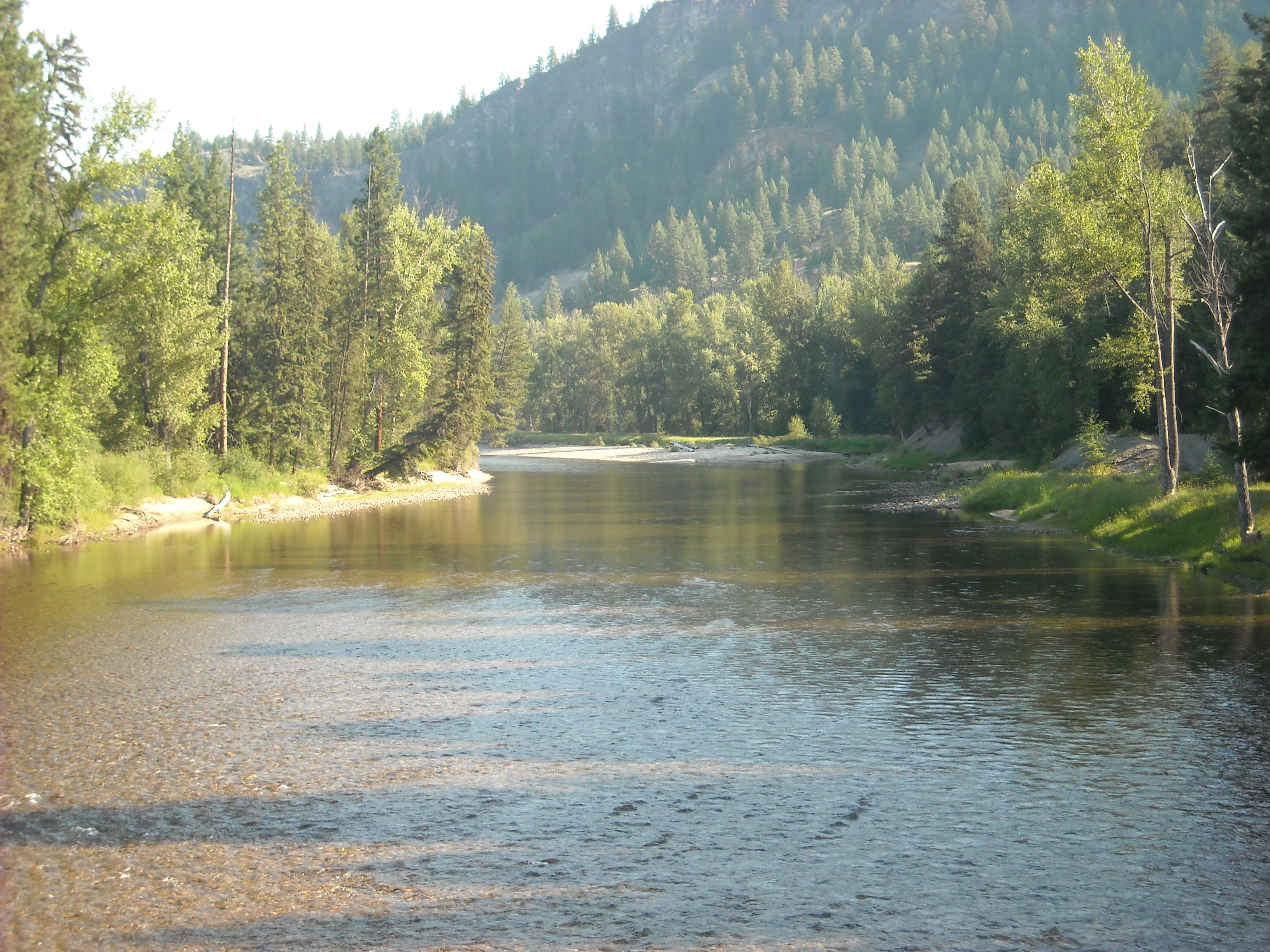
A peaceful river flows through a valley surrounded by a dense forest of evergreen and deciduous trees under clear daylight.
The Kettle River flowing through the Kettle River Recreation Area in British Columbia.

Kettle River Recreation Area history and protected-area timeline

The history of the Kettle River Recreation Area is closely tied to the broader story of the Kettle Valley Railway and the late nineteenth-century mining boom in southern British Columbia. In 1887, discoveries of gold and silver in the region drew thousands of American miners, prompting the provincial and federal governments to support the construction of a railway that would better connect the region to the rest of the province.

The challenging topography of the river valleys made construction slow, and the railway took nearly twenty years to complete. By the time the line opened in 1915, the mineral rush had largely subsided. The railway then operated through the Kettle River valley until 1973, shaping settlement and travel patterns in the region across nearly six decades of service.

After the tracks between Midway and Penticton were removed in 1979 and 1980, the abandoned right-of-way eventually became part of the Great Trail of Canada. The recreation area itself was established on 6 July 1972, while the railway was still operating. In the decades since, the old rail corridor has been transformed from an industrial transport route into a recreational trail that anchors the park's visitor experience.

Kettle River Recreation Area landscape and geographic character

The landscape of Kettle River Recreation Area is shaped by the sharp S-bend of the Kettle River, which produces steep slopes, a curving river corridor, and an unusual sense of enclosure within a relatively small area. The river's bend creates flat riverside margins suitable for a beach and camping, while the surrounding terrain rises into dry, open slopes typical of the southern interior of British Columbia.

The terrain sits within the dry climatic zone that extends through the boundary region near Rock Creek, Midway, and Osoyoos. Rather than the dense coniferous rainforests that dominate much of the province, the slopes here support open stands of ponderosa pine interspersed with bunchgrass, giving the area a parkland-like appearance during the warmer months. The river itself provides a contrasting green ribbon of cottonwoods and riparian growth, visible from the historic railway bridge that spans the waterway.

The dry-belt setting is central to the park's visual identity. The combination of warm, exposed slopes, a winding river, and sparse coniferous cover produces a landscape that feels distinctly different from other provincial parks in British Columbia. It is a place where canyon curves, dry pine forest, and cottonwood stands converge along a single stretch of the Kettle River.

Kettle River Recreation Area ecosystems, habitats, and plant life

The ecological character of Kettle River Recreation Area is defined by its dry-belt vegetation, which is unusual within the broader provincial context. The river corridor supports old-growth stands of black cottonwood, a species that thrives in moist riparian zones and can reach impressive sizes where it is undisturbed. These mature cottonwoods contribute to the structural complexity of the riverside habitat and provide nesting cavities and perches for cavity-nesting birds and other wildlife that depend on older trees.

Away from the river, the slopes carry open ponderosa pine stands mixed with bunchgrass. This ponderosa pine-bunchgrass plant community is characteristic of dry, fire-adapted interior landscapes and is much more commonly associated with regions to the south of British Columbia. Its presence within the recreation area gives the park a conservation role in preserving habitat types that are not widespread in the province.

The transition between riparian cottonwood and dry upland pine-bunchgrass creates a compressed mosaic of habitat types within the 179 hectare site. This juxtaposition of moist and dry environments supports a more diverse set of plant communities than the area's modest size might suggest, and it forms the basis of the park's ecological importance.

Kettle River Recreation Area wildlife and species highlights

Wildlife use of Kettle River Recreation Area reflects the mix of riparian and dry upland habitats within the park. The mature cottonwoods along the river provide habitat for cavity-nesting birds, small mammals, and also species that benefit from large, old trees in interior valleys. The open ponderosa pine stands and adjacent bunchgrass slopes, in turn, are suited to wildlife more typical of dry, open interior landscapes.

The river itself adds an aquatic dimension, supporting freshwater life associated with the Kettle River system. While the recreation area is compact and primarily set up for recreation rather than wildlife observation, the structural diversity of its habitats gives it a broader ecological footprint than its small area might at first suggest. The old-growth cottonwoods and dry pine slopes together represent habitat for species that depend on these increasingly uncommon vegetation types within British Columbia.

The combination of riparian and dry-belt elements makes the park a useful site for viewing the wildlife communities of British Columbia's southern interior, even though it is not primarily managed for that purpose.

Kettle River Recreation Area conservation status and protection priorities

From a conservation perspective, Kettle River Recreation Area is significant for protecting vegetation patterns that are uncommon in British Columbia. The old-growth cottonwood stands along the river and the dry ponderosa pine-bunchgrass communities on the surrounding slopes represent habitats more typical of drier regions further south. Preserving these communities within a protected area helps maintain ecological diversity in the provincial system.

The recreation area is also part of the broader effort to repurpose abandoned industrial corridors for ecological and recreational benefit. The transformation of the former Kettle Valley Railway right-of-way into a section of the Great Trail of Canada illustrates how transportation corridors can be converted into long-term conservation and recreation assets. The protected status of the river corridor helps limit development pressure on sensitive riparian and dry-slope habitats.

Although the site is small, its dual role as a recreational destination and a refuge for uncommon interior dry-belt vegetation gives it real conservation relevance within the BC Parks network.

Kettle River Recreation Area cultural meaning and human context

The cultural dimension of Kettle River Recreation Area is tied largely to the legacy of the Kettle Valley Railway and the mining era that shaped southern British Columbia in the late nineteenth and early twentieth centuries. The railway's construction brought workers and communities into the region, and even after the original economic motivations faded, the rail line remained an important feature of the landscape for decades.

Today, this industrial heritage is reinterpreted through the Great Trail of Canada and the repurposed railway bridge. The abandoned rail corridor has become a connective cultural thread that links outdoor recreation, regional identity, and historical memory. The park therefore sits at the intersection of natural landscape and human history, reflecting the role of rail transportation in opening up the province's southern interior.

Top sights and standout views in Kettle River Recreation Area

Kettle River Recreation Area offers a distinctive blend of dry-belt ecology, riverside scenery, and converted railway heritage within a compact footprint. The sharp S-bend of the Kettle River creates an enclosed, curving landscape that enhances the sense of place, while the old-growth cottonwoods and ponderosa pine-bunchgrass communities give the park an ecological identity that is unusual within British Columbia.

The historic Kettle Valley Railway corridor, now part of the Great Trail of Canada, and the repurposed pedestrian bridge add cultural depth to the experience. Combined with a public beach, campground, and access for inner tubing on the river, the recreation area delivers a layered experience where natural features and human history meet along a single stretch of the Kettle River.

Best time to visit Kettle River Recreation Area

Kettle River Recreation Area is best experienced during the warmer months of late spring, summer, and early autumn, when the dry-belt landscapes are at their most inviting and the river supports swimming, inner tubing, and riverside hiking. Summer brings warm temperatures, exposure of the open ponderosa pine slopes, and active use of the beach and campground.

In the cooler shoulder seasons, the park takes on a quieter atmosphere, with reduced crowding and cooler conditions for walking the trail corridor and exploring the historic bridge. The dry climate of the region means that visits are generally least comfortable during the colder months, when overnight temperatures drop sharply in the open valley landscape and river-based recreation becomes less practical.
Monthly climate preview

Long-term representative point measurements tracking monthly temperature and precipitation variation.

Kettle River Recreation Area Climate Normals, Annual Temperature and Precipitation Rhythm

Kettle River Recreation Area experiences a measured annual temperature and precipitation rhythm across its representative elevation, ranging from severe winter minimums to warm summer maximums. Reviewing the complete twelve-month profile provides deeper context for long-term climate normals and regional weather patterns.
Annual mean4 °C
-8 °C17 °C
Jan-8°
Feb-7°
Mar-3°
Apr
May
Jun13°
Jul17°
Aug17°
Sep12°
Oct
Nov-3°
Dec-8°
Warmest month
July

17.2 °C

Coolest month
December

-8.5 °C

Wettest month
November

2.3 mm/day

Driest month
August

0.7 mm/day

Park location guide

Geography guide, regional context, and park location map for Kettle River Recreation Area

Kettle River Recreation Area park geography, regions, and map view in Canada

Understand where Kettle River Recreation Area sits in Canada through a broader geographic reading of the surrounding landscape, nearby location context, and its mapped position within the national park landscape.

How Kettle River Recreation Area fits into Canada

Canada is a federal parliamentary constitutional monarchy spanning North America from the Atlantic to the Pacific and Arctic Oceans. With a population of over 41 million, it is officially bilingual in English and French at the federal level. The country gained independence from the United Kingdom through a gradual process culminating in 1982.

Wider geography shaping Kettle River Recreation Area in Canada

Canada occupies the northern portion of North America, sharing its longest international border with the United States. The country extends from the Atlantic Ocean to the Pacific Ocean and northward into the Arctic Ocean, giving it the longest coastline of any nation.

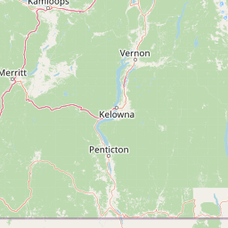
Map view of Kettle River Recreation Area

Use this park location map to pinpoint Kettle River Recreation Area in Canada, understand its exact geographic position, and read its mapped placement within the surrounding landscape more clearly.

Pigeon | © OpenStreetMap contributors

Location context for Kettle River Recreation Area

British Columbia

Explore detailed park imagery highlighting old-growth cottonwoods, ponderosa pine stands, and winding river corridors.

Kettle River Recreation Area Photos and Scenery: Visualizing the Interior Dry-Belt Landscape

Visual documentation provides a clear look at the dry southern interior terrain, featuring exposed slopes and riparian cottonwood galleries along the winding waterway. Examining these protected habitats reveals the distinct ecological character of the river corridor and surrounding valley environments.

A peaceful river flows through a valley surrounded by a dense forest of evergreen and deciduous trees under clear daylight.

Park atlas

Compare adjacent southern interior landscapes and connected regional reserves

Explore Parks Near Kettle River Recreation Area and Surrounding Protected Lands

Browse protected areas and river valleys situated near Kettle River Recreation Area to evaluate regional dry-belt ecosystems. Comparing adjacent terrain reveals broader conservation patterns across the southern interior of British Columbia.
State or regional parkBritish Columbia
About 29 km away#1 closest

East

Jewel Lake Provincial Park: Geography and Protected Landscapes in British Columbia

A ridge-flanked valley lake with historic mining heritage

Jewel Lake Provincial Park preserves a narrow, forty-nine hectare freshwater ecosystem in the Boundary region of British Columbia. The area provides a detailed look at ridge-flanked mountain terrain and the historical mining landscape that defines this section of the West Kootenay-Boundary corridor.

Area
0.49 km²
Established
1981
IUCN
II
Climate
Temperate
A pale, minimalist watercolor painting showing a soft green treeline along a riverbank with light mountain silhouettes in the distance.
State or regional parkBritish Columbia
About 43 km away#2 closest

West

Inkaneep Provincial Park: Mapped Geography and Protected Riparian Landscapes in British Columbia

Conserving riverine habitats and arid valley biodiversity in the Okanagan

Inkaneep Provincial Park occupies a distinct corridor along the Okanagan River, safeguarding vital riparian vegetation and cottonwood forests in one of Canada's driest regions. This protected area supports important ecological functions, ranging from salmon habitat restoration to providing refuge for rare bird species, representing a meaningful component of the south Okanagan geographic network.

Area
0.205 km²
Established
1956
IUCN
II
Relief
Lowland
A watercolor painting of a mountain landscape with soft-colored rolling hills, a green forest line, and foreground vegetation on a white background.
Protected landscapeWashington
About 77 km away#3 closest

Southwest

Okanogan, Wenatchee National Forest: A Comprehensive Look at Washington's Protected Mountain Landscapes

Mapping ecological gradients and wilderness boundaries across the eastern Cascade Range

Spanning from the moist coniferous forests of the western Cascades to the arid plateaus of the Okanogan, this massive national forest protects an unmatched diversity of terrain. Explore the intricate geography of river-carved valleys, glacial cirques, and remote wilderness areas that characterize this critical environmental corridor in the Pacific Northwest.

Area
6,066.33 km²
Established
1911
Visitors
397K annual
Relief
Mountain
State or regional parkBritish Columbia
About 86 km away#4 closest

East

King George VI Provincial Park: Protected Riparian Woodland in Southeastern British Columbia

Ecological atlas of old growth cottonwood habitats

King George VI Provincial Park functions as a significant conservation enclave in southeastern British Columbia, known for its dense stands of old growth black cottonwood. These mature trees create a unique closed canopy environment that serves as critical nesting ground for specialized bird species. This park represents a focused, passive protected area that preserves rare riparian forest structure against a backdrop of regional highway corridors and mixed use terrain.

Area
1.619 km²
Established
1937
IUCN
III
Relief
Lowland
Protected landscapeBritish Columbia
About 98 km away#5 closest

North

Graystokes Provincial Park: Geographic Overview of British Columbia Protected Wilderness

Exploring the Okanagan Highland plateau and alpine wetland systems

Graystokes Provincial Park functions as a key protected landscape in the British Columbia interior. This backcountry expanse is defined by its rolling plateau terrain, encompassing alpine wetlands, meadows, and riparian habitats set against a backdrop of Engelmann spruce and subalpine fir forests.

Area
119.58 km²
Established
2001
Relief
Highland
Climate
Alpine
A horizontal watercolor painting depicting a soft-focus mountain landscape with rolling green meadows, patches of coniferous forest, and distant pale mountains under a white sky.
State or regional parkBritish Columbia
About 118 km away#6 closest

West

E. C. Manning Provincial Park: A Comprehensive Geographic Atlas and Protected Area Overview

Mountainous terrain and ecological transitions in southern British Columbia

Spanning the cross section of the Canadian Cascades, E. C. Manning Provincial Park preserves a high-elevation landscape of wildflowers, glacial valleys, and mountain ridges. The protected area links temperate coastal rainforests with the arid interior, providing a study in regional hydrology and subalpine ecology defined by the Hozameen Range and the northern reaches of the Pacific Crest Trail.

Area
836.71 km²
Established
1941
IUCN
II
Visitors
1.1M annual
Wildlife reserveWashington
About 119 km away#7 closest

Southwest

Lake Chelan-Sawtooth Wilderness: Geographic Atlas and Protected Landscape Overview

North Cascades Wilderness in Washington State

Located in the north-central Cascade Range of Washington, this protected wilderness area contains 63 glacial lakes and extensive alpine terrain. The region offers a complex landscape of cirques, subalpine meadows, and forested valleys that connect directly to the larger North Cascades protected network. Use this atlas to examine its mountainous geography and defined conservation boundaries.

Area
619.4 km²
Established
1984
IUCN
Ib
Relief
Mountain
State or regional parkBritish Columbia
About 121 km away#8 closest

North

Kalamalka Lake Provincial Park and Protected Area: Mapped Geography and Regional Context

A conservation landscape of the North Okanagan valley

Kalamalka Lake Provincial Park and Protected Area preserves 978 hectares of essential grassland and lakeshore habitats in British Columbia. The area features a complex mosaic of open meadows and mixed forest stands, offering a detailed perspective on the ecological transitions found within the Okanagan Valley. Its geography is defined by the shimmering turquoise waters of Kalamalka Lake, reflecting the unique interplay between seasonal mineral shifts and the surrounding arid terrain.

Area
9.78 km²
Established
1975
IUCN
II
Relief
Upland

Common questions about visiting, size, designation, and location context for Kettle River Recreation Area

Kettle River Recreation Area FAQs for park facts, access, geography, and protected area context

Find quick answers about Kettle River Recreation Area, including protected-area facts, park geography, trail and visitor context, and how the park fits into its surrounding country and regional landscape.
MoriAtlas Explorer

Continue Your Protected Areas Search Across the Global Atlas

Deepen your exploration by continuing the structured search for national parks and protected areas worldwide. Utilize the comprehensive filtering capabilities to compare different conservation landscapes and refine your understanding of global park geography. Discover more about the distribution and characteristics of protected natural areas.

Global natural geography


