Mori Atlas logo
National parkKhangai Nuruu National Park

Discover the mapped geography and diverse ecosystems of this expansive national park in central Mongolia.

Khangai Nuruu National Park: A Protected Landscape Atlas of Mongolia's Khangai Mountains

Khangai Nuruu National Park represents a significant protected landscape within Mongolia's central region, primarily situated across the Khangai Mountains. This national park safeguards a rich tapestry of ecosystems, from alpine meadows and taiga forests to productive steppe and riparian zones, offering a comprehensive view of regional geography. Its extensive mapped boundaries encompass varied terrain, providing a crucial atlas-level understanding of its protected status and ecological significance within Mongolia's vast natural heritage.

National ParkMongoliaKhangai MountainsAlpine MeadowTaiga ForestSteppe

Khangai Nuruu National Park

National park

Park overview

Structured park overview, official facts, and landscape profile for Khangai Nuruu National Park

Khangai Nuruu National Park park facts, protected area profile, and essential visitor context

Review the core facts for Khangai Nuruu National Park, including designation, size, terrain, visitor scale, habitats, and operating context in one park-focused overview.

About Khangai Nuruu National Park

Khangai Nuruu National Park represents one of Mongolia's significant protected areas, established in 1996 to preserve the unique alpine and steppe ecosystems of the Khangai Mountains region. The park stretches over 200 kilometres from the western foothills of the Khangai range to Kharkhorin on the eastern slope, following the course of the Orkhon River through its eastern sector. This extensive east-west orientation captures remarkable ecological variation, with the landscape transitioning from western mountain terrain through the river valleys to the eastern steppe environments. The area holds particular significance within Mongolia's protected area network not only for its biological diversity but also for its proximity to historically significant sites, including the ancient capital of Kharkhorin in the Orkhon River valley. The park's elevation range of 1,700 to 2,700 metres creates distinct ecological zones, with the highest elevations featuring rounded mountain summits and exposed rock formations characteristic of the Khangai range.

Quick facts and research context for Khangai Nuruu National Park

Khangai Nuruu National Park is located in central Mongolia within the Khangai Mountains region. The protected area spans roughly 888,500 hectares and was established in 1996. Elevations within the park range from 1,700 to 2,700 metres, with rounded mountain summits and bare rock exposures at upper elevations. The eastern portion of the park follows the Orkhon River valley, while the Tuin River flows through the western sector. The park contains the Khuisiin Naiman Nuur (Eight Lakes) Nature Reserve in its south-central area.

Protection and recognition

Tracking official terrestrial protection status and national conservation frameworks in Mongolia.

Khangai Nuruu National Park Protection Status and Conservation Designations

Researchers can verify the documented terrestrial protection status and official designation details for Khangai Nuruu National Park. Consolidating verified conservation parameters helps geographers analyze the formal legal frameworks governing Mongolia's critical mountain ecosystems.

Protection details

Protection scope
Terrestrial
Transboundary protection
No
Park context

Deeper park guide and search-rich context for Khangai Nuruu National Park

Khangai Nuruu National Park history, landscape, wildlife, and travel context

Explore Khangai Nuruu National Park through its history, landscape character, ecosystems, wildlife, conservation priorities, cultural context, and seasonal travel timing in a structured park guide built for atlas discovery and search intent.

Why Khangai Nuruu National Park stands out

Khangai Nuruu National Park is best known for its exceptional ecological diversity, encompassing multiple habitat types including steppe, riparian forests, larch taiga, and alpine meadows within a single protected area. The park protects critical habitat for endangered raptors including Pallas's fish eagle and the Saker's Falcon, earning recognition as an Important Bird Area from BirdLife International. The transition between two distinct ecoregions within the park, from the Khangai Mountains alpine meadow in the west to the Selenge-Orkhon forest steppe along the Orkhon River in the east, creates a unique mosaic of ecosystems that supports notable biodiversity.

Khangai Nuruu National Park history and protected-area timeline

Khangai Nuruu National Park was established in 1996 as part of Mongolia's expanding national park system during the country's transition period following the end of the socialist era. The creation of the park reflected Mongolia's commitment to conserving its unique mountain and steppe ecosystems, particularly in the ecologically diverse Khangai Mountains region. The Ministry of Environment and Green Development of Mongolia serves as the governing body responsible for park management and conservation efforts. Since establishment, the park has been recognized for its biodiversity value, particularly through its designation as an Important Bird Area by BirdLife International, highlighting the global significance of the raptor populations it protects.

Khangai Nuruu National Park landscape and geographic character

The landscape of Khangai Nuruu National Park is defined by the rolling, rounded terrain characteristic of the Khangai Mountains, with bare rock exposed at the highest elevations while lower slopes support productive vegetation. The park's western sector features the Tuin River flowing southward through mountainous terrain, while the eastern half follows the upper Orkhon River valley, a watercourse of significant historical and ecological importance in Mongolia. The valley floors are relatively flat, supporting steppe vegetation communities, while the surrounding slopes transition through forested zones to alpine meadows at the highest elevations. Within the south-central portion of the park lies the Khuisiin Naiman Nuur, or Eight Lakes, Nature Reserve, adding further ecological and landscape diversity to the protected area.

Khangai Nuruu National Park ecosystems, habitats, and plant life

The nature of Khangai Nuruu National Park is distinguished by its remarkable habitat diversity, encompassing four distinct ecosystem types within a single protected area. The relatively flat valley floors support steppe vegetation communities, while rivers and streams are bordered by riparian forests that provide critical habitat corridors. The higher slopes feature extensive larch taiga forests, along with pine and mixed forest communities, creating a forested zone that transitions to alpine meadows at the highest elevations around 2,700 metres. This vertical zonation, combined with the park's position spanning two major ecoregions, creates exceptional ecological complexity. The western portion of the park falls within the Khangai Mountains alpine meadow ecoregion, while the eastern sector along the Orkhon River is part of the Selenge-Orkhon forest steppe ecoregion, each supporting distinct assemblages of plant and animal species.

Khangai Nuruu National Park wildlife and species highlights

Khangai Nuruu National Park supports significant wildlife populations, with particular importance attached to its endangered raptor species. The park provides critical habitat for Pallas's fish eagle, a species listed as endangered, which inhabits the riparian zones and wetland areas along the Orkhon River and other watercourses within the park. The Saker's Falcon, another endangered raptor species, is found throughout the steppe and forest-steppe habitats of the protected area. The combination of steppe, forest, and riparian habitats supports a diverse bird community, leading to the park's designation as an Important Bird Area by BirdLife International. The riparian forests along the rivers provide important nesting and foraging habitat for these apex predators, while the surrounding steppe and meadows support additional wildlife assemblages.

Khangai Nuruu National Park conservation status and protection priorities

Khangai Nuruu National Park holds IUCN Category II protection status, recognizing its significance as a national park that protects natural ecosystems of outstanding value. The park's conservation importance is amplified by its role in protecting habitat for globally endangered species, including Pallas's fish eagle and the Saker's Falcon, both of which face significant population pressures across their ranges. The designation as an Important Bird Area by BirdLife International acknowledges the park's critical role in global bird conservation, particularly for raptor species. The park's management under Mongolia's Ministry of Environment and Green Development aims to balance conservation of these significant ecosystems while maintaining the ecological processes that support the region's biodiversity.

Khangai Nuruu National Park cultural meaning and human context

The Khangai Nuruu National Park region holds deep historical significance within Mongolian cultural heritage. The eastern portion of the park follows the Orkhon River valley, an area of tremendous historical importance that was home to the Mongol Empire's capital at Kharkhorin. The Orkhon River valley is considered one of the cradles of Mongolian civilization, with archaeological evidence of human habitation spanning millennia. The park's landscape has been shaped by the traditional pastoralist cultures that have moved through these mountains and valleys for generations, creating the cultural and ecological context that defines this region of central Mongolia.

Top sights and standout views in Khangai Nuruu National Park

Khangai Nuruu National Park offers visitors the opportunity to experience one of Mongolia's most ecologically diverse protected areas, with its unique combination of alpine meadows, larch taiga forests, riparian woodlands, and steppe environments. The park's position spanning the transition between the Khangai Mountains alpine meadow and Selenge-Orkhon forest steppe ecoregions creates remarkable ecological diversity within a single protected landscape. The presence of endangered raptors including Pallas's fish eagle and the Saker's Falcon provides exceptional wildlife observation opportunities, particularly along the Orkhon River corridor. The Eight Lakes area in the south-central sector adds further attraction to this mountain wilderness.

Best time to visit Khangai Nuruu National Park

The best time to visit Khangai Nuruu National Park is during the summer months of June through August, when temperatures are mild and the alpine meadows are in bloom. This period offers the most accessible conditions for exploration of the park's diverse habitats, with the steppe and forest areas at their most productive. The cold semi-arid climate means that winter conditions are severe, with significant snowfall and cold temperatures limiting access. Summer visits allow for observation of the park's wildlife in active periods, though visitors should be prepared for the variable mountain weather conditions that characterize this region of central Mongolia.
Monthly climate preview

Analyzing the extreme annual temperature shifts and monthly precipitation trends at high elevation

Long-Term Climate Normals and Weather by Month for Khangai Nuruu National Park

Long-term records at the 2440-meter representative elevation point show extreme temperature shifts from average lows below minus 30 degrees Celsius in Month 1 to mild averages near 13 degrees in Month 7. Accessing the complete climate dataset reveals monthly precipitation trends and historical weather-by-month cycles across the park terrain.
Annual mean-4 °C
-21 °C13 °C
Jan-21°
Feb-17°
Mar-11°
Apr-2°
May
Jun10°
Jul13°
Aug10°
Sep
Oct-3°
Nov-12°
Dec-18°
Warmest month
July

12.6 °C

Coolest month
January

-20.7 °C

Wettest month
July

2.6 mm/day

Driest month
January

0.1 mm/day

Park location guide

Geography guide, regional context, and park location map for Khangai Nuruu National Park

Khangai Nuruu National Park park geography, regions, and map view in Mongolia

Understand where Khangai Nuruu National Park sits in Mongolia through a broader geographic reading of the surrounding landscape, nearby location context, and its mapped position within the national park landscape.

How Khangai Nuruu National Park fits into Mongolia

Mongolia is a landlocked sovereign state in East Asia, known for its vast steppe landscapes, nomadic culture, and historical significance as the heartland of the Mongol Empire founded by Genghis Khan in 1206. The country has a population of approximately 3.5 million people and is the world's most sparsely populated sovereign state. Ulaanbaatar is the capital and largest city, home to roughly half the population.

Wider geography shaping Khangai Nuruu National Park in Mongolia

Mongolia is located in East Asia, landlocked between Russia to the north and China to the south. The country occupies the Mongolian Plateau and features diverse terrain including grassy steppe, mountains in the north and west, and the Gobi Desert in the south. It covers 1,564,116 km2, making it the second largest landlocked country in the world.

Map view of Khangai Nuruu National Park

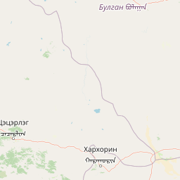
Use this park location map to pinpoint Khangai Nuruu National Park in Mongolia, understand its exact geographic position, and read its mapped placement within the surrounding landscape more clearly.

Pigeon | © OpenStreetMap contributors
Park atlas

Trace the surrounding protected landscapes and national parks in Mongolia's central Khangai Mountains, offering geographic context beyond Khangai Nuruu.

Discover Other Protected Areas Near Khangai Nuruu National Park, Mongolia's Central Khangai Mountains

Explore a curated list of national parks and other protected areas found near Khangai Nuruu National Park in central Mongolia. These geographic records help users compare diverse landscapes, from alpine meadows to steppe ecosystems, and understand the broader conservation efforts in the Khangai Mountains region.
Protected areaArkhangai Province
About 121 km away#1 closest

Northeast

Ögii Lake Protected Area: A Comprehensive Geographic Overview of the Mongolian Steppe

Freshwater basin and wetland geography in Arkhangai Province

Ögii Lake represents a pivotal protected landscape in central Mongolia, defined by its 25 square kilometer surface area and gentle, shallow underwater topography. This site functions as an ecological nexus for migratory waterbirds and is essential for understanding the transition between open grassland and the mountainous terrain of the Khangai region.

Area
25.7 km²
Established
2006
Relief
Lowland
Access
Access unknown
National parkMongolia
About 164 km away#2 closest

Northwest

Khorgo-Terkhiin Tsagaan Nuur National Park: A Volcanic Landscape and Wetland Atlas

Mapping volcanic terrain and migratory bird habitats in the Khangai Mountains.

This protected area features the dramatic remnants of the Taryatu-Chulutu volcanic field, centered on the extinct Khorgo volcano and the deep waters of Terkhiin Tsagaan Lake. The park provides an essential refuge for avian populations in its western marshlands, contrasting with the surrounding forest steppe. Explore the unique topography and ecological boundaries of this significant Mongolian conservation landscape.

Area
8 km²
Established
1965
IUCN
II
Relief
Mountain
National parkArkhangai Province
About 166 km away#3 closest

Northwest

Khorgo-Terkhiin Tsagaan Nuur National Park: Volcanic Terrain and Lake Geography

A protected highland landscape in Arkhangai Province

Explore the distinct physical geography of Khorgo-Terkhiin Tsagaan Nuur National Park, where the extinct Khorgo volcano borders a vast freshwater lake. This protected area offers a look at the mosaic of birch forest and alpine slopes within the Khangai range. The mapping of this central Mongolian site reveals how volcanic activity and mountain hydrology converge to shape its unique natural horizon.

Relief
Mountain
Climate
Alpine
Scope
Terrestrial
Water
Water-dominated
National parkMongolia
About 172 km away#4 closest

East

Khogno Khan National Park: A National Park with Distinct Mongolian Landscape Identity

Explore its mapped terrain and regional geographic context.

Khogno Khan National Park is a designated national park offering a specific focus for protected landscape discovery. Users can explore its geographic placement within Mongolia and understand its role as a mapped natural area. The park's identity as a protected territory provides critical context for those interested in the atlas of East Asian landscapes and regional geography, highlighting a distinct area for geographic study.

Area
841 km²
Established
2003
IUCN
II
Relief
Mountain
Wildlife reserveÖvörkhangai Province
About 227 km away#5 closest

South

Taatsiin Tsagaan Lake Wildlife Reserve: Mapped Landscapes and Wetland Conservation in Övörkhangai Province

A critical saline wetland node within the Gobi Desert ecosystem.

Taatsiin Tsagaan Lake represents a substantial inland saline water body, defined by its role as an Important Bird Area and key wetland habitat. As part of the Valley of the Lakes, this wildlife reserve demonstrates the ecological significance of arid-land basins. Explore its geographic boundaries and position within the broader Gobi Desert landscape to understand its value in regional avian conservation.

Area
252 km²
Established
1998
Relief
Lowland
Climate
Arid
Protected areaBayankhongor Province
About 237 km away#6 closest

Southwest

Valley of the Lakes: Protected Intermontane Basin and Wetland Geography in Mongolia

A vast depression defined by saline lake chains and arid steppe ecosystems.

Stretching between the Khangai and Gobi-Altai mountain systems, the Valley of the Lakes features a complex mosaic of solonchak soils, takir flats, and barchan sand dunes. This protected area is recognized for its internationally significant wetland habitats and its role as a key geographic link in the Central Asian migratory flyway.

Area
456 km²
Established
1998
Relief
Upland
Scope
Terrestrial
National parkMongolia
About 259 km away#7 closest

South

Ikh Bogd Uul National Park: Explore Mongolia's Protected Landscape and Geography

Discover mapped terrain and protected area context.

Ikh Bogd Uul National Park offers a unique window into Mongolia's protected landscapes. This page delves into the park's specific geographic setting, its mapped boundaries, and its character as a national park. Users can explore the foundational data for understanding its natural terrain and its role within the country's conservation atlas, providing a concrete basis for geographic discovery and appreciating the scope of protected areas in the region.

Area
2,629 km²
Established
2008
IUCN
II
Relief
Mountain
National parkZavkhan Province
About 306 km away#8 closest

West

Tarvagatai Nuruu National Park: Zavkhan Province Protected Landscape Atlas

Unique steppe-to-forest transition and mountainous terrain.

Tarvagatai Nuruu National Park represents a critical protected area within Mongolia's Zavkhan Province, noted for its expansive mountainous terrain and significant ecological diversity. The park's landscape is defined by the Tarvagatai Range, featuring flat-topped ridges, glacial valleys, and dramatic elevation changes. It masterfully showcases the transition from semi-arid steppe to dense coniferous forests, highlighting a visually striking ecological boundary anchored by the prominence of Mount Otgontenger, the highest peak in the Khangai Mountains.

Area
5,467 km²
Established
2000
IUCN
II
Relief
Mountain

Common questions about visiting, size, designation, and location context for Khangai Nuruu National Park

Khangai Nuruu National Park FAQs for park facts, access, geography, and protected area context

Find quick answers about Khangai Nuruu National Park, including protected-area facts, park geography, trail and visitor context, and how the park fits into its surrounding country and regional landscape.
MoriAtlas Explorer

Continue Your Protected Areas Search Across the Global Atlas

Deepen your exploration by continuing the structured search for national parks and protected areas worldwide. Utilize the comprehensive filtering capabilities to compare different conservation landscapes and refine your understanding of global park geography. Discover more about the distribution and characteristics of protected natural areas.

Global natural geography