

Mori Atlas logo
National parkKhuean Srinagarindra National Park

Discover the mapped boundaries and natural terrain of this national park in Thailand's Kanchanaburi Province.

Khuean Srinagarindra National Park: Protected Landscape and Geographic Context in Kanchanaburi

Khuean Srinagarindra National Park represents a significant protected landscape within Thailand's Kanchanaburi Province. As a designated national park, it offers a focused area for geographic discovery and understanding of natural terrain. This entry provides essential context for exploring its protected boundaries and regional landscape, serving as a key point for atlas-driven exploration of protected areas in Southeast Asia.

National ParkThailandWestern Forest ComplexReservoirKanchanaburiWaterfall

Khuean Srinagarindra National Park

National park

Park overview

Structured park overview, official facts, and landscape profile for Khuean Srinagarindra National Park

Khuean Srinagarindra National Park park facts, protected area profile, and essential visitor context
Review the core facts for Khuean Srinagarindra National Park, including designation, size, terrain, visitor scale, habitats, and operating context in one park-focused overview.

About Khuean Srinagarindra National Park

Khuean Srinagarindra National Park occupies a significant position within Thailand's western forest landscape, forming part of the extensive Western Forest Complex that spans the border regions with Myanmar. The park's defining geographic feature is the Srinagarind Reservoir, created when the Srinagarind Dam was completed in 1980, which subsequently became the central element around which the national park was organized in 1981. This reservoir and its network of inflowing streams create a diverse aquatic and riparian environment contrasting with the surrounding forested slopes. The park's location in the rain shadow of the western mountains produces a distinctive climate regime with lower rainfall than surrounding areas, supporting forest ecosystems adapted to these conditions. The protection of this large contiguous forest area serves important ecological functions including watershed protection, wildlife corridor connectivity, and preservation of Thailand's western forest biodiversity. The park's boundary encompasses multiple districts and interfaces with eight neighboring protected areas, reflecting its regional significance in conservation planning.

Quick facts and research context for Khuean Srinagarindra National Park

Located about 105 kilometers northwest of Kanchanaburi town, the park encompasses portions of Sai Yok, Si Sawat, and Thong Pha Phum districts. The park's terrain is characterized by mountainous forest landscape centered on the Srinagarind Reservoir, with several tributaries including Huai Mae Khamin, Huai Kha Khaeng, Huai Mae Wong, Huai Kriankrai, and Huai Mae Phlu feeding into the reservoir. The park sits within the rain shadow of surrounding hills, resulting in lower average rainfall than other parts of Thailand and temperature extremes ranging from 8°C in December to 44°C in April. The protected area is bounded by multiple other protected areas including Erawan National Park, Sai Yok National Park, Thong Pha Phum National Park, and Thung Yai Naresuan Wildlife Sanctuary.

Park context

Deeper park guide and search-rich context for Khuean Srinagarindra National Park

Khuean Srinagarindra National Park history, landscape, wildlife, and travel context
Explore Khuean Srinagarindra National Park through its history, landscape character, ecosystems, wildlife, conservation priorities, cultural context, and seasonal travel timing in a structured park guide built for atlas discovery and search intent.

Why Khuean Srinagarindra National Park stands out

The park is best known for its dramatic reservoir-based landscape centered on the Srinagarind Reservoir, a large impoundment of the Khwae Yai River that creates extensive wetland and aquatic habitats within the protected area. The Huai Mae Khamin Waterfall, a seven-tiered cascade flowing from the eastern mountains toward the Khwae Yai River, represents the park's most visited attraction. The park also contains significant cave systems including Tham Sawan with prehistoric cave paintings and Tham Phra Prang, which houses a Buddha image and served as a hiding place for Thai soldiers during the 18th-century Burmese-Siamese wars. The combination of reservoir recreation, forest-covered mountains, and cultural-historical cave sites distinguishes this park within Thailand's protected area system.

Khuean Srinagarindra National Park history and protected-area timeline

The establishment of Khuean Srinagarindra National Park in 1981 marked the formal protection of a region with deeper historical significance. The park's cave systems, particularly Tham Phra Prang, served as strategic hiding locations for Thai soldiers during the Burmese-Siamese wars of the 18th century, when military forces sought refuge in the region's natural formations. The modern history of the area is closely tied to the construction of the Srinagarind Dam on the Khwae Yai River, completed in 1980, which created the reservoir that now defines the park's central geography. Following dam completion, the Thai government designated the surrounding watershed and forest areas as a national park in December 1981, making it the 39th such protected area in Thailand's national park system. This designation formalized protection for a landscape that had long served as a historical refuge and ecological repository.

Khuean Srinagarindra National Park landscape and geographic character

The physical landscape of Khuean Srinagarindra National Park is characterized by mountainous terrain supporting tropical forest ecosystems, with the Srinagarind Reservoir as the dominant aquatic feature. The park's elevation reaches approximately 1,100 meters at its highest points, with the terrain descending toward the reservoir basin. Multiple streams and tributaries flow into the reservoir, including Huai Mae Khamin, Huai Kha Khaeng, Huai Mae Wong, Huai Kriankrai, and Huai Mae Phlu. The surrounding hills create a rain shadow effect that distinguishes the local climate from surrounding regions, resulting in lower precipitation despite the tropical latitude. The landscape supports three primary forest types: mixed deciduous forest, dry dipterocarp forest, and dry evergreen forest, each dominating different elevational zones and aspects within the park.

Khuean Srinagarindra National Park ecosystems, habitats, and plant life

The ecological character of Khuean Srinagarindra National Park is defined by the intersection of terrestrial forest ecosystems with the extensive reservoir and riparian environments. The park supports three distinct forest types that reflect the rain shadow conditions: mixed deciduous forest, dry dipterocarp forest, and dry evergreen forest. These forest formations host diverse plant communities adapted to seasonal variation and the relatively drier conditions compared to eastern Thailand. The reservoir and its tributaries create aquatic and wetland habitats that supplement the terrestrial forest environments, supporting species dependent on water sources throughout the year. The park forms part of the Western Forest Complex, a network of protected areas that maintains ecological connectivity across the Thai-Burmese border region, allowing for wildlife movement and genetic exchange across a broader landscape than any single protected area could provide.

Khuean Srinagarindra National Park wildlife and species highlights

Khuean Srinagarindra National Park supports substantial wildlife populations across multiple taxonomic groups. Mammal species documented in the park include Asian elephant, Bengal tiger, gaur, sambar deer, Asian wild dog, and various primates including Phayre's leaf monkey and white-handed gibbon. The park records 142 bird species across 52 families, representing both passerine and non-passerine species including the greater racket-tailed drongo, orange-breasted trogon, and wreathed hornbill. Reptile diversity includes species such as the reticulated python, water monitor, and various pit vipers. Amphibian and fish species are documented in the park's freshwater systems, with the reservoir and tributaries supporting fish communities including the giant snakehead fish and greater brook carp. The combination of forest habitats, riparian corridors, and reservoir environments creates diverse ecological niches supporting this biodiversity.

Khuean Srinagarindra National Park conservation status and protection priorities

Khuean Srinagarindra National Park plays an important role in Thailand's protected area network as a component of the Western Forest Complex, a coordinated system of national parks, wildlife sanctuaries, and other protected areas spanning the country's western regions. The park's large contiguous forest area provides watershed protection for the Srinagarind Reservoir and downstream water users, while maintaining wildlife corridors connecting to neighboring protected areas including Thung Yai Naresuan Wildlife Sanctuary and several other national parks. The designation of this area as a national park in 1981 recognized its ecological significance within Thailand's western forest biome, which supports species of conservation concern including large mammals such as elephants and tigers. The park's management under the Department of National Parks, Wildlife and Plant Conservation integrates protection of both terrestrial and aquatic ecosystems within a single protected area framework.

Khuean Srinagarindra National Park cultural meaning and human context

The region now within Khuean Srinagarindra National Park carries historical significance dating to the Burmese-Siamese wars of the 18th century. The park's cave systems, particularly Tham Phra Prang, served as hiding places for Thai soldiers during periods of conflict with neighboring Burma. These caves retain cultural relevance, with Tham Phra Prang continuing to house a Buddha image, combining natural formations with religious significance. The landscape has supported human communities over extended periods, with the establishment of the Srinagarind Dam in 1980 fundamentally altering the hydrology of the region by creating the reservoir that now forms the park's central feature. This relatively recent hydrological transformation coexists with older patterns of human interaction with the forest and cave environments.

Top sights and standout views in Khuean Srinagarindra National Park

The park's primary attraction is Huai Mae Khamin Waterfall, a seven-tiered cascade descending from the eastern mountain source to join the Khwae Yai River. The cave systems represent another significant highlight, with Tham Sawan containing prehistoric cave paintings within its 150-meter length, Tham Neramit featuring impressive stalactite and stalagmite formations, and Tham Phra Prang combining geological formations with a Buddha image. The Srinagarind Reservoir itself offers recreational opportunities on Thailand's larger artificial lakes, with the surrounding forested mountains providing scenic backdrops and hiking potential. The diversity of forest types within a single protected area, combined with the reservoir's aquatic environments, creates ecological variety that supports the park's wildlife populations.

Best time to visit Khuean Srinagarindra National Park

The park can be visited throughout the year, though the cool season from November to February offers the most comfortable temperatures for outdoor activities, with minimum temperatures around 8°C. The hot season from March to April brings peak temperatures reaching 44°C, which may limit daytime outdoor activities. The rainy season from mid-April to mid-October brings higher precipitation but also greener landscapes and potentially reduced visitor numbers. The rain shadow effect means the park receives less annual rainfall than other parts of Thailand, approximately 1,600mm annually, making it relatively less affected by monsoonal conditions than some neighboring protected areas. Visitors seeking waterfall viewing may find the post-rainy season period offers the most reliable water flow at Huai Mae Khamin.

Park location guide

Geography guide, regional context, and park location map for Khuean Srinagarindra National Park

Khuean Srinagarindra National Park park geography, regions, and map view in Thailand
Understand where Khuean Srinagarindra National Park sits in Thailand through a broader geographic reading of the surrounding landscape, nearby location context, and its mapped position within the national park landscape.

How Khuean Srinagarindra National Park fits into Thailand

Thailand is a Southeast Asian nation formerly called Siam, located in mainland Southeast Asia. It operates as a unitary parliamentary constitutional monarchy under King Vajiralongkorn. The country borders Myanmar, Laos, Cambodia, and Malaysia, with maritime boundaries involving Vietnam, Indonesia, and India. Thailand has a population of nearly 66 million and covers approximately 513,120 km². Historically, the Sukhothai Kingdom marks the beginning of Thai history, followed by the powerful Ayutthaya Kingdom.

Wider geography shaping Khuean Srinagarindra National Park in Thailand

Thailand occupies mainland Southeast Asia with borders to Myanmar (west/northwest), Laos (east/northeast), Cambodia (southeast), and Malaysia (south). The country has coastline along the Gulf of Thailand to the southeast and the Andaman Sea to the southwest. The territory covers approximately 513,120 km².

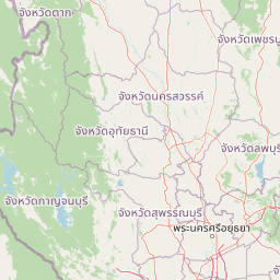
Map view of Khuean Srinagarindra National Park

Use this park location map to pinpoint Khuean Srinagarindra National Park in Thailand, understand its exact geographic position, and read its mapped placement within the surrounding landscape more clearly.

Pigeon | © OpenStreetMap contributors

Location context for Khuean Srinagarindra National Park

Kanchanaburi Province
Park atlas

Explore the regional context of protected areas, tracing their geographical spread across Thailand's Western Forest Complex.

Discover Other National Parks and Protected Areas Surrounding Khuean Srinagarindra National Park
Browse national parks and protected areas geographically connected to Khuean Srinagarindra National Park, including other sites within the expansive Western Forest Complex in western Thailand. This comparison reveals the broader regional spread of conservation landscapes, offering deeper insights into diverse ecosystems and varied protected area management.
National parkKanchanaburi Province

Chaloem Rattanakosin National Park: National Park Status and Geographic Exploration

Mapped protected area in Kanchanaburi Province, Thailand.

Chaloem Rattanakosin National Park represents a crucial protected landscape within Kanchanaburi Province, identified as a national park. This entry offers a foundation for understanding its geographic boundaries and regional context, providing essential detail for atlas-based exploration of Thailand's natural protected areas and their mapped distribution across the landscape.

Area
59 km²
Established
1980
IUCN
II
Visitors
31.5K annual
National parkKanchanaburi Province

Lam Khlong Ngu National Park: A Protected National Park in Kanchanaburi Province

Explore mapped boundaries and regional geography.

Lam Khlong Ngu National Park offers a distinct protected landscape within Kanchanaburi Province. As a national park, it contributes to the understanding of Thailand's diverse geography and conservation areas. Users can explore its mapped features and discover its place within the broader regional context of protected lands.

Area
673 km²
Established
2009
Relief
Mountain
Climate
Tropical
National parkSuphan Buri Province

Phu Toei National Park: National Park Atlas and Mapped Landscape Exploration in Suphan Buri Province

Discover the protected area's geographic context and natural terrain.

Phu Toei National Park is a designated national park offering a unique perspective on protected landscapes within Suphan Buri Province, Thailand. This park serves as a crucial entity for atlas-based geographic discovery, highlighting its specific mapped boundaries and the surrounding natural terrain. Users can explore the park's inherent geographic character and its role within Thailand's network of conservation areas.

Area
317 km²
Established
1998
IUCN
II
Visitors
8.8K annual
Watercolor illustration of a serene landscape featuring a body of water, distant hills, and green vegetation
National parkKanchanaburi Province

Sai Yok National Park: Protected Landscape Boundaries and Regional Geographic Context

Explore the mapped terrain and park geography within Kanchanaburi.

Sai Yok National Park serves as a vital protected area within Kanchanaburi Province, offering a clear focus for geographic exploration and atlas-based understanding. This entry details the park's specific mapped boundaries and its role within the broader regional landscape context, providing essential data for comprehending its natural geography and conservation significance.

Area
500 km²
Established
1980
IUCN
II
Visitors
67.7K annual
National parkKanchanaburi Province

Khao Laem National Park: Kanchanaburi Province Protected Landscape Atlas

Discover mapped terrain and regional geographic context.

Investigate Khao Laem National Park as a distinct protected landscape situated in Thailand's Kanchanaburi Province. This entry provides detailed geographic insights, focusing on mapped boundaries and the park's position within the region's natural atlas. It's designed for users seeking specific protected-area data and landscape context rather than general visitor information.

Area
1,497 km²
Established
1991
IUCN
II
Visitors
48.6K annual
National parkKanchanaburi Province

Thong Pha Phum National Park: A Protected Landscape in Kanchanaburi Province, Thailand

National park mapped geography and regional context.

Thong Pha Phum National Park is a significant national park in Thailand, situated within Kanchanaburi Province. This page details its protected area status and provides essential geographic context, enabling users to explore its mapped boundaries and understand its role within the regional landscape. Focus on discovery of its natural terrain and atlas-relevant characteristics.

Area
1,236 km²
Established
2009
IUCN
II
Visitors
123.3K annual
National parkNakhon Sawan Province

Mae Wong National Park: National Park Protected Area and Geographic Setting

Mapped boundaries and regional landscape of Mae Wong.

Investigate Mae Wong National Park, a designated national park offering insights into its protected landscape identity. This entry provides structured geographic data, focusing on the park's mapped boundaries and its position within the broader regional context of Nakhon Sawan Province. Examine its role as a significant protected area for atlas-based discovery and geographic understanding.

Area
894 km²
Established
1987
IUCN
II
Visitors
51.8K annual
National parkKamphaeng Phet Province

Khlong Lan National Park: National Park Protected Landscape and Geography

Explore mapped boundaries and regional context in Kamphaeng Phet Province.

Delve into the specifics of Khlong Lan National Park, a protected area designated as a national park in Thailand's Kamphaeng Phet Province. This page offers a structured view of its geographic scope, emphasizing mapped park boundaries and the surrounding natural terrain. Understand its role as a significant protected landscape within the regional geography.

Area
300 km²
Established
1985
IUCN
II
Visitors
206.4K annual

Common questions about visiting, size, designation, and location context for Khuean Srinagarindra National Park

Khuean Srinagarindra National Park FAQs for park facts, access, geography, and protected area context
Find quick answers about Khuean Srinagarindra National Park, including protected-area facts, park geography, trail and visitor context, and how the park fits into its surrounding country and regional landscape.
MoriAtlas Explorer

Continue Your Protected Areas Search Across the Global Atlas

Deepen your exploration by continuing the structured search for national parks and protected areas worldwide. Utilize the comprehensive filtering capabilities to compare different conservation landscapes and refine your understanding of global park geography. Discover more about the distribution and characteristics of protected natural areas.

Global natural geography