
Mori Atlas logo
Nature reserveKies- und Sandgrube von Dudenhofen

Examining the post-extraction terrain and mapped amphibian breeding habitats of this regional nature preserve

Kies- und Sandgrube von Dudenhofen: A Protected Wetland Landscape and Nature Reserve in Hessen

(Naturschutzgebiet Kies- und Sandgrube von Dudenhofen)

Kies- und Sandgrube von Dudenhofen represents a vital seventeen-hectare nature reserve situated within the forested geography of the Landkreis Offenbach district. This protected site features a complex network of shallow open-water basins formed by historical sand and gravel extraction, now serving as a critical refuge for specialized wetland plants and amphibian populations. The site provides a unique study in post-industrial landscape transformation, where deliberate conservation efforts maintain the hydrologic integrity of flooded pits against the backdrop of surrounding woodlands.

nature reservewetlandpost-extraction landscapegravel pitamphibian habitatmoor frog
Stylized vector art of a landscape featuring a waterfall flowing into a river between rocky cliffs, with coniferous trees, wildflowers in the foreground, and a mountain in the background under a pale sun.

Kies- und Sandgrube von Dudenhofen

Nature reserve

Park overview

Structured park overview, official facts, and landscape profile for Kies- und Sandgrube von Dudenhofen

Kies- und Sandgrube von Dudenhofen park facts, protected area profile, and essential visitor context

Review the core facts for Kies- und Sandgrube von Dudenhofen, including designation, size, terrain, visitor scale, habitats, and operating context in one park-focused overview.

About Kies- und Sandgrube von Dudenhofen

Kies- und Sandgrube von Dudenhofen is a protected area in the German state of Hesse, located within the municipal territory of Rodgau in the district of Landkreis Offenbach. Situated southeast of the Dudenhofen settlement and surrounded by forest, the reserve represents a relatively uncommon protected-area type in inland Hesse: a former extraction site that has been allowed to develop into a biologically valuable mosaic of open water, wet meadow, and woodland.

Its origins are closely tied to the region's building-materials industry. The pits were originally created through sand and gravel mining, and the subsequent flooding of these worked-out areas produced a network of shallow pools with fluctuating water levels. That unintentional hydrology, combined with the surrounding woodland buffer, created conditions that proved unusually attractive to amphibians and to a set of moisture-dependent plant species that are otherwise rare in the densely settled Rhine-Main lowlands.

The reserve was formally designated in 1995 and is currently managed as a Habitat/Species Management Area under IUCN Category IV, with day-to-day oversight provided by the lower nature conservation authority of Landkreis Offenbach. Despite its modest size of around 17 hectares, it sits within a broader network of nature reserves across Landkreis Offenbach and plays a disproportionate role in conserving certain species in the southern Rhine-Main region.

Access is deliberately limited in order to minimize disturbance to sensitive breeding populations. Visitors reach the site along a few maintained forest tracks, and an observation point allows quiet viewing of the open-water zones without entering the core breeding areas.

Quick facts and research context for Kies- und Sandgrube von Dudenhofen

Kies- und Sandgrube von Dudenhofen is a nature reserve (Naturschutzgebiet) in Hesse, Germany, located in the Landkreis Offenbach within the municipal area of Rodgau. It lies southeast of the Dudenhofen district, close to the Rodgau Kalksandsteinwerk, and is reached via cleared paths through surrounding forest.

The site was designated in 1995 and carries the official NSG identifier 1438024, with the World Database on Protected Areas reference 164067. It covers about 17.32 hectares of forest and meadow at an elevation of roughly 125 to 132 meters above sea level and is managed by the local nature conservation authority of Landkreis Offenbach.

Protection and recognition

Documented conservation records, management scope, and protected area context

Kies- und Sandgrube von Dudenhofen Protection Status and Recognition Data

Examine the official protection status, designation history, and administrative scope associated with Kies- und Sandgrube von Dudenhofen. Review structured data parameters, database identifiers, and verified recognition metrics for this protected landscape.

Protection details

WDPA ID
164067
Park context

Deeper park guide and search-rich context for Kies- und Sandgrube von Dudenhofen

Kies- und Sandgrube von Dudenhofen history, landscape, wildlife, and travel context

Explore Kies- und Sandgrube von Dudenhofen through its history, landscape character, ecosystems, wildlife, conservation priorities, cultural context, and seasonal travel timing in a structured park guide built for atlas discovery and search intent.

Why Kies- und Sandgrube von Dudenhofen stands out

The reserve is best known for its shallow-water amphibian breeding habitats, which originated from former sand and gravel quarrying. It is one of the most important sites in the region for the moor frog (Rana arvalis) and the spring frog (Rana dalmatina), both of which depend on the early-season flooded pits. Beyond its amphibian significance, the site is also appreciated for its small but distinctive flora, including pillwort (Pilularia globulifera), round-leaved sundew (Drosera rotundifolia), and marsh clubmoss (Lycopodiella inundata), along with a notable diversity of ground lichens. The combination of disturbed-quarry hydrology and surviving wetland vegetation makes it a characteristic example of a post-industrial habitat-type reserve.
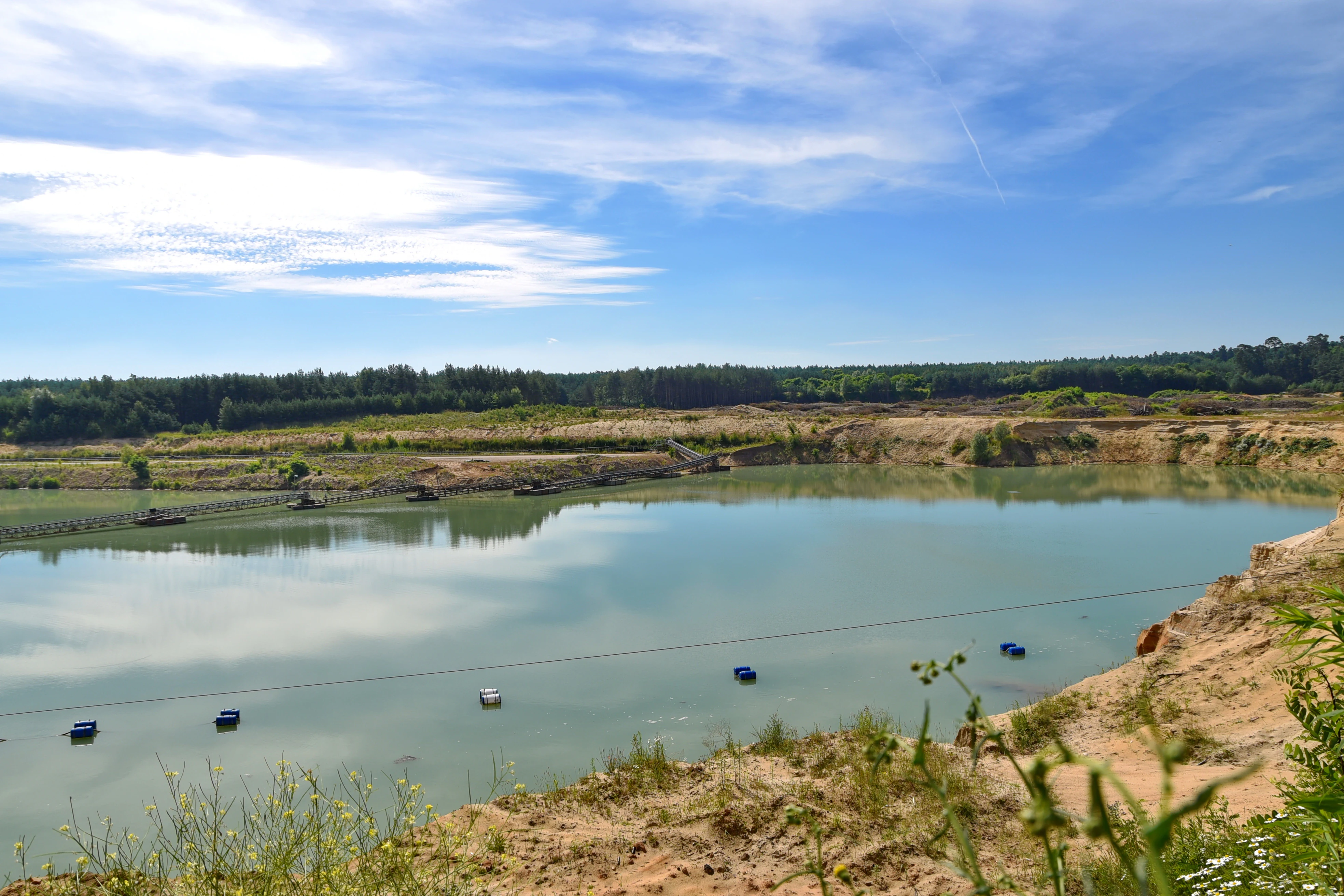
A wide view of a turquoise pond within an old gravel and sand pit, surrounded by sandy slopes and a forest line under a blue sky.
A view of the former gravel and sand pit now serving as a nature reserve in Dudenhofen.

Kies- und Sandgrube von Dudenhofen history and protected-area timeline

The landscape that became Kies- und Sandgrube von Dudenhofen was originally shaped by sand and gravel extraction associated with the regional building-materials industry, including activity connected to the nearby Rodgauer Kalksandsteinwerk. As the pits were worked out and dewatering ceased, the depressions began to fill with water and gradually developed into a complex of shallow pond-like habitats embedded within the surrounding woodland.

Recognition of the ecological value of this transformation led to the formal designation of the site as a nature reserve (Naturschutzgebiet) in 1995, under the identifier 1438024. Since then it has been managed by the lower nature conservation authority of Landkreis Offenbach as a Habitat/Species Management Area within the IUCN framework. Management efforts have centered on maintaining the open-water character of the pits and the surrounding successional vegetation, even though the variable water depths of the breeding pools have posed an ongoing challenge for both amphibians and rare wetland plants.

Kies- und Sandgrube von Dudenhofen landscape and geographic character

The reserve occupies a gently undulating section of the Rhine-Main lowlands at roughly 125 to 132 meters above sea level, set within a larger forested landscape southeast of Dudenhofen. Rather than dramatic relief, its physical character is defined by a series of depressions and shallow basins that trace the geometry of the old sand and gravel workings.

These basins form the central open-water axis of the site, flanked by a patchwork of wet meadows, successional scrub, and forest that blends into the broader Rodgau woodland around it. Mineral substrates exposed by past extraction give the area a distinctive feel, with sandy and gravelly margins, transitions into waterlogged ground, and areas of damp open soil that have become habitats in their own right. The result is a small but visually varied post-extraction landscape that contrasts with the denser forest that surrounds it.

Kies- und Sandgrube von Dudenhofen ecosystems, habitats, and plant life

Ecologically, the reserve is dominated by the interplay between the shallow former-quarry waters and the adjacent wet meadows and woodland. The hydrology of the site is unusually dynamic: water levels fluctuate sharply across seasons, producing a shifting mosaic of fully flooded depressions, saturated margins, and temporarily dry basins.

This variable wetland environment supports plant communities adapted to unstable conditions. Among the most notable species are pillwort (Pilularia globulifera), a small aquatic fern of conservation concern; round-leaved sundew (Drosera rotundifolia), a carnivorous plant of open, nutrient-poor wet ground; and marsh clubmoss (Lycopodiella inundata), which occurs on damp exposed substrates. Ground lichens also form an important part of the site's biological character, contributing to the diversity of open-soil habitats that the quarrying process inadvertently created.

Surrounding woodland and meadow vegetation further buffers the open-water areas, providing shade, shelter, and terrestrial habitat structure that supports amphibians during non-breeding phases and contributes to the overall habitat heterogeneity of the reserve.

Kies- und Sandgrube von Dudenhofen wildlife and species highlights

The reserve's wildlife profile is shaped most strongly by its amphibian communities, for which the site is best known. It supports important populations of the moor frog (Rana arvalis) and the spring frog (Rana dalmatina), both of which depend on the early-season flooded pits as breeding habitat.

The fluctuating water depths of these breeding pools are, however, a double-edged feature: while they create dynamic habitats, they also expose amphibian populations to significant risk in years when water levels drop too quickly or fail to rise sufficiently during the breeding season. This has been identified as one of the central conservation pressures affecting the reserve.

Beyond amphibians, the open-water areas attract a range of waterbirds. Species recorded include little grebe (Zwergtaucher), little ringed plover (Flussregenpfeifer), great egret (Silberreiher), grey heron (Graureiher), and Canada goose (Kanadagans). The combination of open water, wet margins, and surrounding woodland makes the reserve a usable stopover and foraging area for both breeding and visiting birdlife in the region.

Kies- und Sandgrube von Dudenhofen conservation status and protection priorities

From a conservation perspective, Kies- und Sandgrube von Dudenhofen illustrates the value of post-industrial landscapes when managed for biodiversity. Although small, the reserve protects a habitat complex, open shallow water combined with wet meadow and forest edge, that has become scarce in the densely populated Rhine-Main region.

The site's principal conservation objective is the preservation and expansion of extensive shallow-water habitat. Maintaining and restoring these open water areas is critical for sustaining the moor frog population and the broader species diversity that depends on them, including rare plants such as pillwort, round-leaved sundew, and marsh clubmoss, along with a notable community of ground lichens.

Under IUCN Category IV, the area is treated as a Habitat/Species Management Area, an approach that recognizes the need for active intervention to maintain the open-water character against natural succession. The key ongoing challenge is hydrological: extreme fluctuations in water depth continue to threaten amphibian breeding success and the long-term viability of the site's most sensitive plant species, making careful water-level management a central part of the reserve's conservation strategy.

Top sights and standout views in Kies- und Sandgrube von Dudenhofen

A compact 17-hectare post-extraction reserve protecting a network of shallow former quarry ponds surrounded by forest and meadow.

Important breeding habitat for moor frog and spring frog, with documented populations of rare wetland plants including pillwort, round-leaved sundew, and marsh clubmoss.

A designated observation point offers low-disturbance viewing of the open-water areas and their waterbird visitors, including little grebe, little ringed plover, great egret, grey heron, and Canada goose.

Best time to visit Kies- und Sandgrube von Dudenhofen

Visit timing at Kies- und Sandgrube von Dudenhofen is largely shaped by the breeding cycles of its amphibians and the seasonal behavior of its birds. Spring is generally the most ecologically active period, when moor frogs and spring frogs use the shallow flooded pits for breeding and waterbird activity around the open water is at its peak. This is also when the dynamic water levels that define the reserve are most visible.

Summer tends to bring a shift in character as water levels drop and exposed muddy margins become more pronounced, which can be a useful period for observing waders and waterbirds foraging along the edges. Late summer and autumn are quieter biologically but can still offer interest in the form of ground lichens, fruit-bearing wetland vegetation, and reduced disturbance overall. Winter visits are possible but expose less of the reserve's defining wetland character.

Monthly climate preview

Long-term temperature ranges and monthly precipitation patterns across representative coordinates

Climate Normals and Annual Weather Rhythms for Kies- und Sandgrube von Dudenhofen

Kies- und Sandgrube von Dudenhofen records measured monthly temperature swings from subfreezing winter minimums to warm summer maximums alongside steady daily precipitation averages. Reviewing the complete twelve-month climatology dataset reveals broader seasonal trends and detailed baseline metrics for the protected landscape.
Annual mean10 °C
0 °C21 °C
Jan
Feb
Mar
Apr10°
May14°
Jun18°
Jul21°
Aug20°
Sep15°
Oct10°
Nov
Dec
Warmest month
July

20.6 °C

Coolest month
January

0.2 °C

Wettest month
July

2.2 mm/day

Driest month
April

1.4 mm/day

Park location guide

Geography guide, regional context, and park location map for Kies- und Sandgrube von Dudenhofen

Kies- und Sandgrube von Dudenhofen park geography, regions, and map view in Germany

Understand where Kies- und Sandgrube von Dudenhofen sits in Germany through a broader geographic reading of the surrounding landscape, nearby location context, and its mapped position within the national park landscape.

How Kies- und Sandgrube von Dudenhofen fits into Germany

Germany is a federal republic in Western and Central Europe with a population of over 83 million across sixteen constituent states. It is Europe's largest economy by nominal GDP and a major global exporter and importer. The capital is Berlin, and the country borders Denmark, Poland, Czech Republic, Austria, Switzerland, France, Luxembourg, Belgium, and the Netherlands.

Wider geography shaping Kies- und Sandgrube von Dudenhofen in Germany

Germany is located in Western and Central Europe, spanning 357,022 km². It borders Denmark to the north, Poland and the Czech Republic to the east, Austria and Switzerland to the south, and France, Luxembourg, Belgium, and the Netherlands to the west. The country has coastlines on the Baltic Sea and North Sea to the north, with the Alps located in the southern region.

Map view of Kies- und Sandgrube von Dudenhofen

Use this park location map to pinpoint Kies- und Sandgrube von Dudenhofen in Germany, understand its exact geographic position, and read its mapped placement within the surrounding landscape more clearly.

Pigeon | © OpenStreetMap contributors

Location context for Kies- und Sandgrube von Dudenhofen

Hessen

Visualizing the post-extraction wetland habitats, shallow waters, and forest margins of the reserve

Kies- und Sandgrube von Dudenhofen Photos and Protected Landscape Scenery

Visual documentation reveals the distinctive post-extraction terrain, shallow open-water basins, and surviving wetland vegetation of Kies- und Sandgrube von Dudenhofen. Examining field photography helps researchers and visitors analyze the precise habitat structure, sandy substrates, and ecological transitions defining this protected nature reserve.

A wide view of a turquoise pond within an old gravel and sand pit, surrounded by sandy slopes and a forest line under a blue sky.

Park atlas

Discover connected regional nature reserves and wetland habitats

Explore Protected Areas and Parks Near Kies- und Sandgrube von Dudenhofen

Browsing other protected areas near Kies- und Sandgrube von Dudenhofen reveals wider regional wetland networks and post-industrial landscapes. Comparing adjacent nature reserves expands geographic understanding of the surrounding Frankfurt Rhine-Main terrain.
Nature reserveLandkreis Offenbach
About 2 km away#1 closest

West

Niederrodener Lache: A Protected Nature Reserve in Landkreis Offenbach, Germany

Brook-side habitat mosaic and regional landscape geography

Niederrodener Lache encompasses 124 hectares of protected woodland and grassland in the Landkreis Offenbach district. Centered on the Lache brook, the reserve hosts a dense interweaving of alder-fringed streams and varied meadow types. Its landscape profile provides a vital refuge for threatened vegetation and wetland biotopes within the suburbanizing Rhine-Main metropolitan area.

Area
1.246 km²
Established
1986
IUCN
IV
Watercolor painting of a soft landscape showing a light orange foreground, a band of green trees and bushes in the midground, and faint rolling hills against a pale yellow sky in the background.
Nature reserveLandkreis Darmstadt-Dieburg
About 2 km away#2 closest

South

Brackenbruch bei Hergershausen: Nature Reserve and Floodplain Ecosystem in Darmstadt-Dieburg

Protected wetland landscapes and Lache stream geography

Located in the Darmstadt-Dieburg district, Brackenbruch bei Hergershausen preserves a characteristic lowland floodplain mosaic. The terrain includes wet meadows, reed beds, and developing oak-hornbeam forests that reflect the natural vegetation of the southern Hessian river valleys. This site maintains essential wetland habitats for regional biodiversity within its protected boundaries.

Area
0.523 km²
Established
1999
Nature reserveHessen
About 4 km away#3 closest

Northeast

Mooskiefernwald von Dudenhofen: Mapped Nature Reserve and Protected Pine Woodland in Hessen

Regional landscape context and protected area boundaries

Study the geographic composition of Mooskiefernwald von Dudenhofen, a specialized nature reserve in Hessen. This 36-hectare site features a rare moss-pine woodland environment and sandy soil habitats, offering a distinct contrast to the industrial and suburban landscape of the Rodgau area.

Area
0.361 km²
Established
1999
IUCN
IV
A watercolor painting of a flat, marshy landscape with soft green trees, grassy plains, and subtle pink tones against a white background.
Nature reserveHessen
About 4.3 km away#4 closest

Northwest

Rodauwiesen bei Rollwald Nature Reserve: Protected Lowland Landscapes in Hessen

Mapping floodplain meadows and reed habitats in the Rodau valley

The Rodauwiesen bei Rollwald nature reserve protects a distinct 32-hectare stretch of lowland floodplain along the Rodau stream in Hessen. This site serves as a vital green refuge, featuring expansive open grassland and significant common reed stands that mirror the historic character of the Untermainebene. Use this geographic reference to study the area's protected boundaries, hydrological terrain, and surviving wet meadow ecosystems within a rapidly developing urban corridor.

Area
0.327 km²
Established
1999
IUCN
IV
Relief
Lowland
A soft watercolor illustration depicting a meadow landscape with a winding stream, distant hills, and foreground wildflowers.
Nature reserveHessen
About 4.5 km away#5 closest

South

Die kleine Qualle von Hergershausen Nature Reserve and Protected Floodplain Landscapes

A preserved wetland fragment in the Hessen region

Die kleine Qualle von Hergershausen stands as a key protected area within the Gersprenz floodplain. This site offers a unique look at remnant wet meadow terrain, serving as an essential breeding and stopover ground for waterbirds in the Darmstadt-Dieburg district. Its geography provides a clear contrast to the surrounding agricultural fields, highlighting the impact of long-term conservation and habitat restoration efforts.

Area
0.27 km²
Established
1984
IUCN
IV
Nature reserveLandkreis Offenbach
About 4.5 km away#6 closest

Northeast

Rotsohl und Thomassee von Dudenhofen Nature Reserve in Landkreis Offenbach, Germany

Protected pine forest, wetland habitat, and pond mosaic

Spanning 52 hectares in the Rhine-Main lowlands, this nature reserve is defined by its compact interplay of dry pine forest and diverse wet open habitats. Known for the Postteiche and Weißensee ponds, it serves as a significant site for both breeding and migratory bird populations in a densely settled metropolitan region.

Area
0.519 km²
Established
1999
IUCN
IV
A horizontal watercolor painting depicting a soft-focus landscape with green fields, patches of wildflowers, and distant low hills.
Nature reserveHessen
About 4.7 km away#7 closest

South

Auf dem Sand zwischen Hergershausen und Altheim Protected Nature Reserve in Hessen

Inland dune and floodplain landscape mapping

Explore the geography of Auf dem Sand zwischen Hergershausen und Altheim, a nature reserve in Hessen. The area serves as a critical habitat mosaic, featuring sandy inland dunes, expansive wet grasslands, and renaturalized floodplain terrain within the Gersprenz valley.

Area
0.233 km²
Established
1998
IUCN
IV
A soft watercolor illustration depicting a calm wetland scene with distant rolling hills, foreground reeds, and overhanging tree branches.
Nature reserveHesse
About 6 km away#8 closest

Southwest

Rallenteich von Eppertshausen Nature Reserve: Protected Landscape and Regional Geography

Wetland and forest mosaic in the Hesse region

Examine the geographic footprint of Rallenteich von Eppertshausen, a significant nature reserve in Hesse, Germany. This 12-hectare protected area showcases a dense mosaic of pond, reedbed, and acidic oak forest that evolved from historical clay mining. Understanding the park's topography and internal landscape zones offers insight into the evolution of post-industrial protected lands.

Area
0.12 km²
Established
1976
IUCN
IV
Relief
Lowland

Common questions about visiting, size, designation, and location context for Kies- und Sandgrube von Dudenhofen

Kies- und Sandgrube von Dudenhofen FAQs for park facts, access, geography, and protected area context

Find quick answers about Kies- und Sandgrube von Dudenhofen, including protected-area facts, park geography, trail and visitor context, and how the park fits into its surrounding country and regional landscape.
MoriAtlas Explorer

Continue Your Protected Areas Search Across the Global Atlas

Deepen your exploration by continuing the structured search for national parks and protected areas worldwide. Utilize the comprehensive filtering capabilities to compare different conservation landscapes and refine your understanding of global park geography. Discover more about the distribution and characteristics of protected natural areas.

Global natural geography