


Mori Atlas logo
National parkKinabalu Park

Mapping the dramatic mountain terrain, climatic zones, and vertical geography of this Borneo landmark.

Kinabalu Park: A Definitive Geographic and Protected Landscape Atlas of Sabah, Malaysia

(Taman Kinabalu)

Kinabalu Park serves as a central protected landmark in Sabah, Malaysian Borneo, encompassing a dramatic vertical gradient that shifts from dense lowland rainforest to high-altitude alpine scrub. This atlas entry provides an overview of the park boundaries and geographic features, including the striking ridges and deep ravines surrounding Mount Kinabalu. Users can examine how the park acts as a center of biological diversity, hosting unique botanical zones across its rugged elevation range within the broader topography of the Crocker Range.

mountain parkWorld Heritage SiteUNESCOtropical mountainBorneoSabah
An illustration of the jagged, rocky peaks of Mount Kinabalu rising above dense green forest, with a small waterfall visible on the mountain slope and a cluster of pink flowers in the foreground.

Kinabalu Park

National park

Park overview

Structured park overview, official facts, and landscape profile for Kinabalu Park

Kinabalu Park park facts, protected area profile, and essential visitor context

Review the core facts for Kinabalu Park, including designation, size, terrain, visitor scale, habitats, and operating context in one park-focused overview.

About Kinabalu Park

Kinabalu Park is one of the most important protected natural areas in Malaysia and a cornerstone of conservation in Southeast Asia. Covering an area around Mount Kinabalu in Sabah, the park protects an extraordinary cross-section of Borneo's natural heritage, from lowland tropical forests to high mountain summit vegetation. Its status as both a national park and a UNESCO World Heritage Site reflects how uniquely rich and ecologically significant this landscape is considered to be on a global scale.

At the heart of the park is Mount Kinabalu, one of the youngest non-volcanic mountains in the world, formed within roughly the last 10 to 35 million years and still slowly rising. The mountain's dramatic vertical profile brings together very different vegetation types, including dense lowland forest, montane cloud forest, coniferous forests, alpine meadows, and stunted summit scrub. This elevational compression, combined with the park's position on the edge of the Crocker Range on Borneo's west coast, creates a biological meeting point where species from the Himalayas, China, Australia, and tropical Asia overlap in one location.

UNESCO has recognized Kinabalu Park as a Centre of Plant Diversity for Southeast Asia, noting that it holds representatives from at least half of all of Borneo's plant species. It is also home to a striking number of endemic species, including those unique to Mount Kinabalu itself. Beyond botany, the park is home to diverse bird, mammal, insect, amphibian, and reptile communities, reinforcing its standing as one of the most important biological sites in the world.

The park is administered by Sabah Parks and is closely connected to outdoor experience in Sabah. Mountain climbing routes such as the Timpohon Trail and the Mesilau Trail lead visitors through the park's varied habitats and toward the summit region, including Low's Peak, named after Hugh Low, the British colonial naturalist who is recorded as the first person to reach the summit. The park headquarters itself, set at a relatively high elevation above sea level in the southern part of the park, is a well-known base for exploration, research, and acclimatization before higher climbs into the mountain's varied climate zones.

Quick facts and research context for Kinabalu Park

Kinabalu Park is located on the west coast of Sabah, Malaysian Borneo, within the Crocker Range and largely within the district of Ranau. The park's headquarters sits at roughly 1,500 meters above sea level, about 88 kilometers from Kota Kinabalu.

Established in 1964, it is one of Malaysia's first national parks and is administered by Sabah Parks. It was inscribed as a UNESCO World Heritage Site in 2000 for both natural criteria ix and x, recognizing its ecological significance and biodiversity. The park contains representatives of at least half of Borneo's plant species, drawing flora from the Himalayas, China, Australia, Malaysia, and pan-tropical sources, which gives the area an unusually wide biogeographic character.

Protection and recognition

Documented terrestrial protection scope, designation history, and UNESCO heritage context.

Kinabalu Park Protection Status and International Recognition Records

Kinabalu Park maintains a documented terrestrial protection status established in the year 2000 alongside official UNESCO World Heritage recognition. Structured records assemble historical designation details and international conservation frameworks associated with this protected landscape.

International recognition

Protection details

Protection scope
Terrestrial
Designated year
2000
Transboundary protection
No
Park context

Deeper park guide and search-rich context for Kinabalu Park

Kinabalu Park history, landscape, wildlife, and travel context

Explore Kinabalu Park through its history, landscape character, ecosystems, wildlife, conservation priorities, cultural context, and seasonal travel timing in a structured park guide built for atlas discovery and search intent.

Why Kinabalu Park stands out

Kinabalu Park is best known as the protected setting of Mount Kinabalu, the highest mountain in Malaysia and one of the most prominent peaks in Southeast Asia, and as a globally important center of plant diversity. What really sets the park apart is the concentration of botanical richness across its dramatic elevational range. From lowland dipterocarp forest up through montane oak, rhododendron, and coniferous forests, and on to alpine meadows and stunted summit vegetation, the park compresses multiple climate zones into a relatively small area. It is especially famous for its spectacular flora, including orchids, rhododendrons, and carnivorous pitcher plants such as Nepenthes rajah, which thrives in the high-elevation habitats of the mountain.
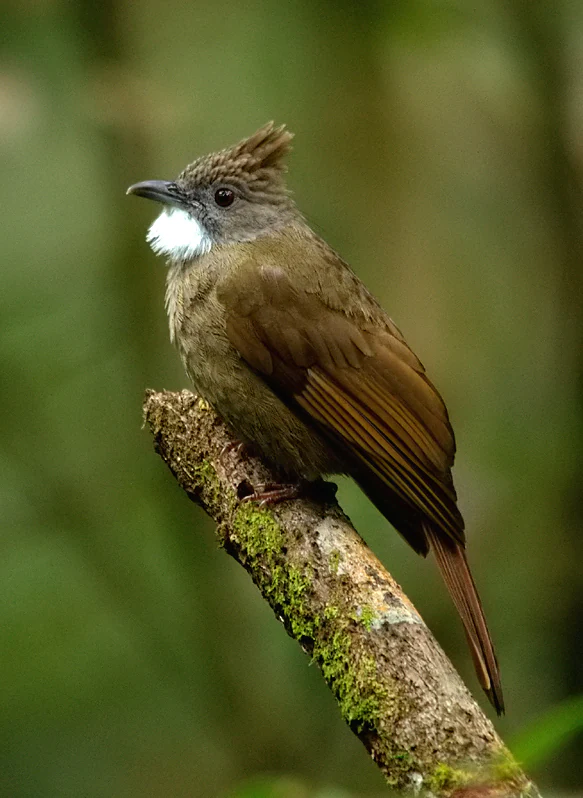
A brown Ochraceous Bulbul bird with a distinctive white throat and small crest perched on a moss-covered branch against a blurred green forest background.
An Ochraceous Bulbul perched on a mossy branch in Kinabalu Park.

Kinabalu Park history and protected-area timeline

The history of Kinabalu Park is closely tied to Mount Kinabalu and the European explorers and scientists who brought international attention to the region. In 1851, British colonial administrator and naturalist Hugh Low led an expedition from Tuaran into the area and became the first recorded person to reach the peak of Mount Kinabalu. In recognition of that achievement, the mountain's highest point was later named Low's Peak.

The idea of formal protection for the area took shape in the twentieth century through scientific interest in the mountain. Botanist E. J. H. Corner led expeditions to the region in 1961 and 1964 on behalf of the Royal Society, and these explorations were influential in promoting the idea of preserving the area. In 1964, the region was gazetted as one of the first national parks of Malaysia, establishing what would become Kinabalu Park.

In December 2000, Kinabalu Park was inscribed as a UNESCO World Heritage Site, becoming the first site in Malaysia to receive this recognition. The park later became part of the expanding Kinabalu UNESCO Global Geopark, recognized by UNESCO in 2023 as part of Malaysia's broader set of natural heritage designations, alongside roles such as World Heritage Site, Man and the Biosphere, and UNESCO Global Geopark. Together these designations have helped shape the conservation, research, and public profile of the park over time.

Kinabalu Park landscape and geographic character

The landscape of Kinabalu Park is dominated by Mount Kinabalu and the surrounding ridges and valleys of the Crocker Range. The mountain itself is one of the most striking features of Borneo, rising from lower forested terrain into a high, rocky summit landscape with steep cliffs, deep ravines, and broad plateau-like areas near the top. Its dramatic relief gives the park its distinctive vertical feel.

A particularly notable feature of the park is Low's Gully, a deep ravine running along the side of the mountain that drops roughly 1.6 kilometers and extends around 10 kilometers near the peak. Such steep terrain shapes both the visual character of the park and the ecological transitions within it. The park headquarters is set in a high-elevation valley area, giving visitors an immediate sense of being inside a mountain environment rather than in a typical lowland park setting.

As elevation rises, the landscape shifts visibly from dense tropical vegetation to mossy cloud forest, exposed rocky slopes, and eventually to the alpine and sub-alpine scrub of the summit area. The combination of rugged mountain terrain, forested valleys, and climatic layering gives the park an unusually varied topography for a relatively compact region, and underlies its status as a key natural feature of Sabah and Borneo.
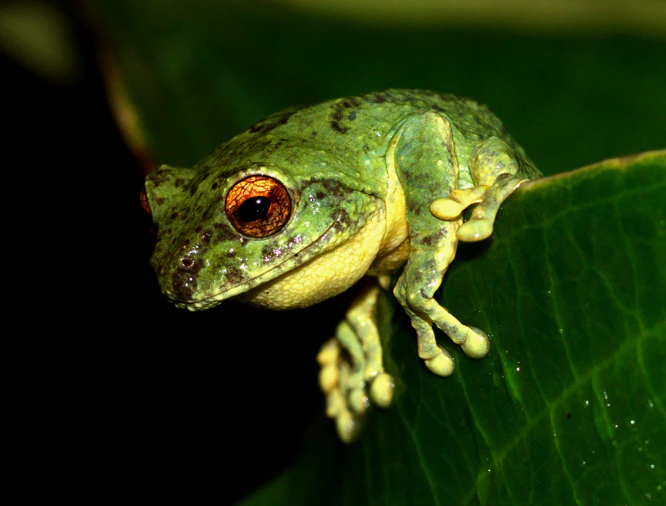
A small green tree frog with large orange eyes perched on the edge of a broad dark green leaf against a black background.
A Philautus bunitus frog resting on a leaf in Kinabalu Park.

Kinabalu Park ecosystems, habitats, and plant life

Kinabalu Park is ecologically significant because it compresses multiple ecological zones into a relatively small area. Its vegetation reflects the strong climatic and elevational changes of Mount Kinabalu, ranging from rich lowland dipterocarp forest at its base through montane oak forest, rhododendron forest, and coniferous forest, and onward into the alpine meadows and stunted bushes that survive on the summit plateau.

The park has been formally identified as a Centre of Plant Diversity for Southeast Asia and is noted for containing representatives of at least half of all of Borneo's plant species. What makes its botanical character particularly unusual is the mixture of floras from very different geographic origins: Himalayan, Chinese, Australian, Malaysian, and pan-tropical elements all occur here. This makes the park a major site for studying plant evolution, endemism, and biogeography.

Orchids, rhododendrons, and carnivorous pitcher plants contribute strongly to the park's botanical identity. Mount Kinabalu is especially famous for Nepenthes rajah and related pitcher plant species, which thrive in the nutrient-poor highland soils and form one of the park's most distinctive ecological characters. Beyond plants, the park's varied habitats support diverse insect, amphibian, and reptile populations, and many of its high-elevation species are found nowhere else on earth.
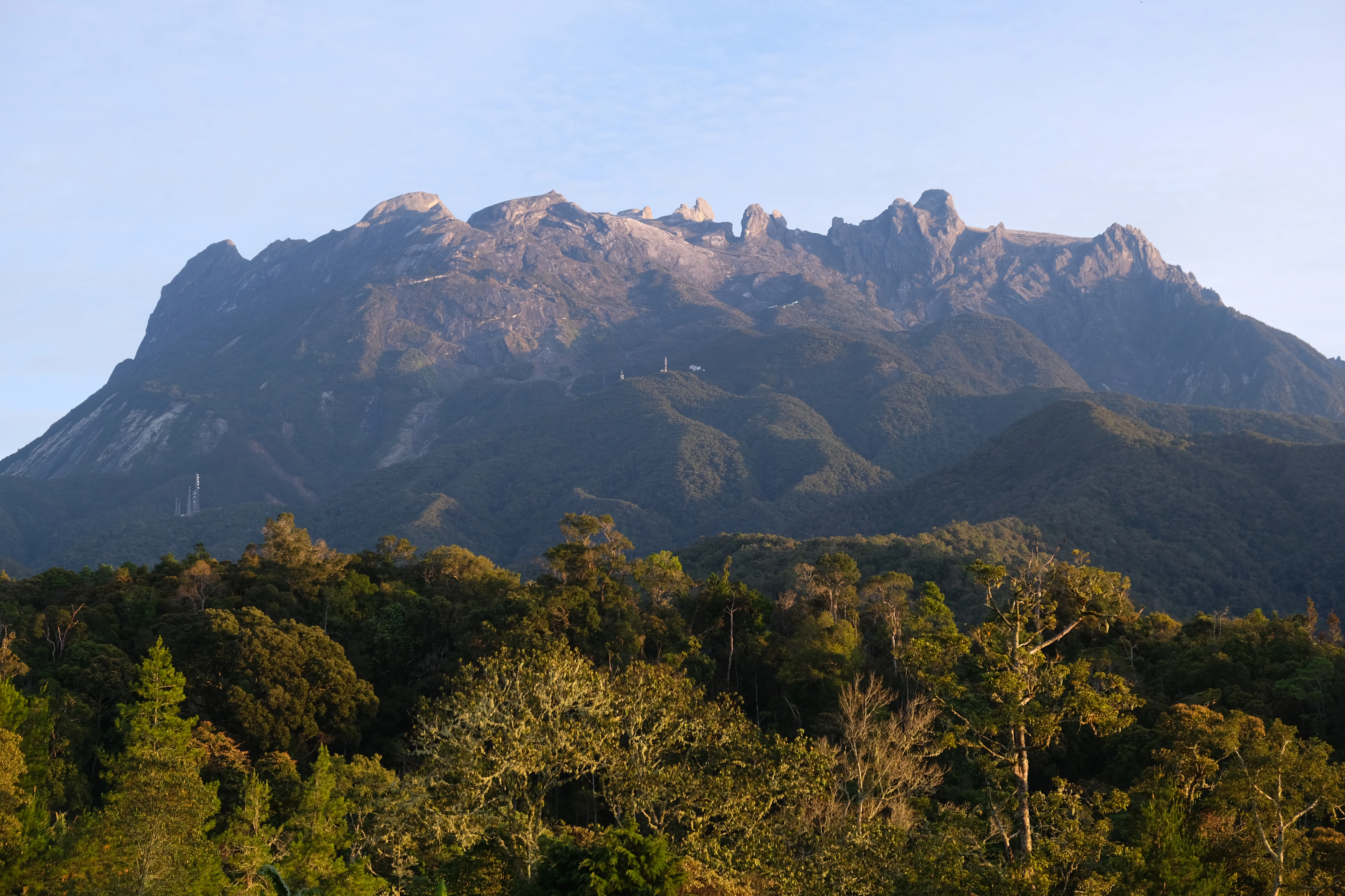
A wide shot of the rugged, rocky peaks of Mount Kinabalu rising above a dense, sunlit tropical forest canopy.
Mount Kinabalu seen from the surrounding foothills.

Kinabalu Park wildlife and species highlights

Kinabalu Park supports an exceptionally diverse animal community, reflecting both its wide elevational range and its position at a biogeographic crossroads between mainland Asia, Sundaic Southeast Asia, and Australasia. The park is home to hundreds of bird and mammal species, along with a rich variety of insects, amphibians, and reptiles, several of which are endemic to Mount Kinabalu.

Among the park's most distinctive animals are endemic invertebrates such as the Kinabalu giant red leech and the Kinabalu giant earthworm, which are closely associated with the wet montane habitats of the mountain. The bird community includes a wide range of forest and highland species, and many of the park's species show patterns of endemism linked to the mountain's isolation and elevation.

Larger mammals, smaller forest mammals, amphibians, and reptiles occur throughout the park's different habitat zones, with species composition shifting as elevation changes. The combination of lowland forest specialists, montane cloud forest species, and high-elevation forms gives the park a layered wildlife character that mirrors its varied vegetation, and contributes to its profile as one of the most ecologically significant protected areas in the region.
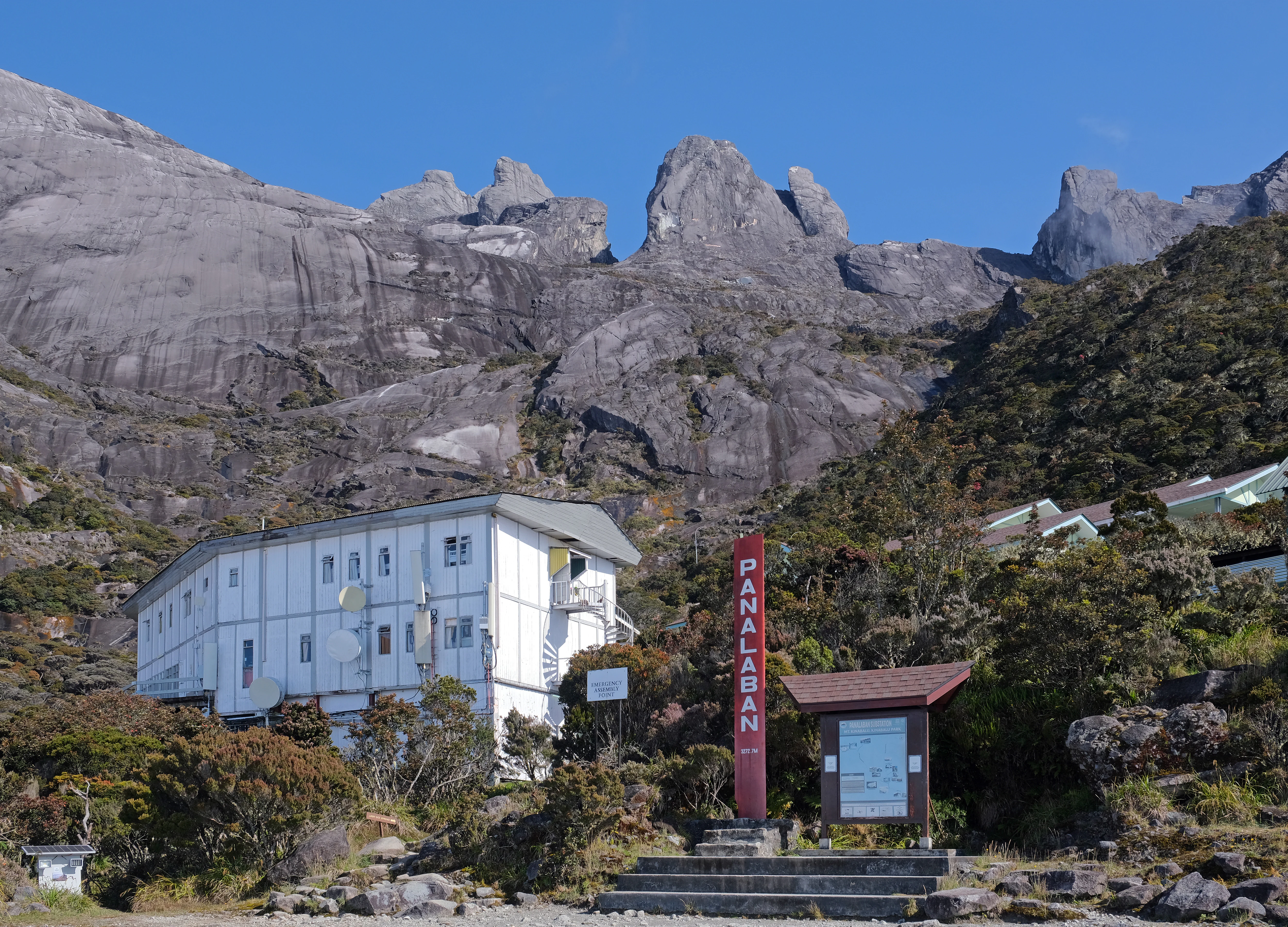
A white multi-story building sits at the base of steep rocky mountain peaks with a red sign labeled PANALABAN nearby.
The Laban Rata Resthouse situated on the slopes of Mount Kinabalu.

Kinabalu Park conservation status and protection priorities

Kinabalu Park's conservation significance is recognized at the international level. As one of the first national parks gazetted in Malaysia and the country's first UNESCO World Heritage Site, it sits at the center of national and global conservation efforts in Sabah. Its designation under World Heritage criteria ix and x reflects both its outstanding ecological processes and its exceptional biodiversity.

Beyond the national park itself, the surrounding landscape is part of the broader Kinabalu UNESCO Global Geopark, which links the park's biodiversity conservation with the protection of its geological features and cultural sites. This integrated recognition reinforces the importance of treating the park and its surroundings as a connected system rather than an isolated reserve.

The park also serves as a critical reservoir of endemism. Many of its plant and animal species are restricted to Mount Kinabalu's highland habitats, meaning their long-term survival depends on continued protection of the park's elevational gradients. By safeguarding one of the most botanically rich mountain environments in Southeast Asia, Kinabalu Park plays an important role in preserving genetic diversity and supporting scientific research into tropical mountain ecosystems.

Kinabalu Park cultural meaning and human context

Kinabalu Park has long been intertwined with the human history of Sabah. The mountain that gives the park its name is a prominent landmark of Borneo and has shaped local identity, traditional livelihoods, and regional imagination. Long before formal protection, the area was already connected to indigenous and rural communities living around its lower slopes and foothills.

European exploration in the nineteenth century brought international attention to Mount Kinabalu, particularly through Hugh Low's 1851 expedition, which was an early milestone in the park's recorded history. Later scientific expeditions, such as those led by E. J. H. Corner in the early 1960s, helped build the case for protecting the area as a national park.

In the modern era, the park plays an important cultural role as a symbol of Sabah's natural heritage. It is a focal point for environmental education, outdoor experience, and regional pride, and the broader Kinabalu UNESCO Global Geopark initiative links its natural values to local communities, including communities in the Kota Belud, Kota Marudu, and Ranau areas, framing the park as a shared regional asset rather than just a protected enclave.

A close-up view of an orb web spider viewed from beneath, showing its yellow and black patterned abdomen, centered on a delicate spider web against a dark, out-of-focus forest background.
An orb web spider seen in its web at Kinabalu Park.

Top sights and standout views in Kinabalu Park

Standout features of Kinabalu Park include Mount Kinabalu itself, the highest peak in Malaysia and the visual and ecological anchor of the park, and the dramatic ravine of Low's Gully along the mountain's flank.

The park's botanical richness, recognized by UNESCO as a Centre of Plant Diversity for Southeast Asia, is another defining highlight, especially its orchids, rhododendrons, and famous pitcher plant populations on the upper mountain. Combined with its status as Malaysia's first World Heritage Site and its place within the Kinabalu UNESCO Global Geopark, these features give the park a remarkably layered natural and cultural identity.
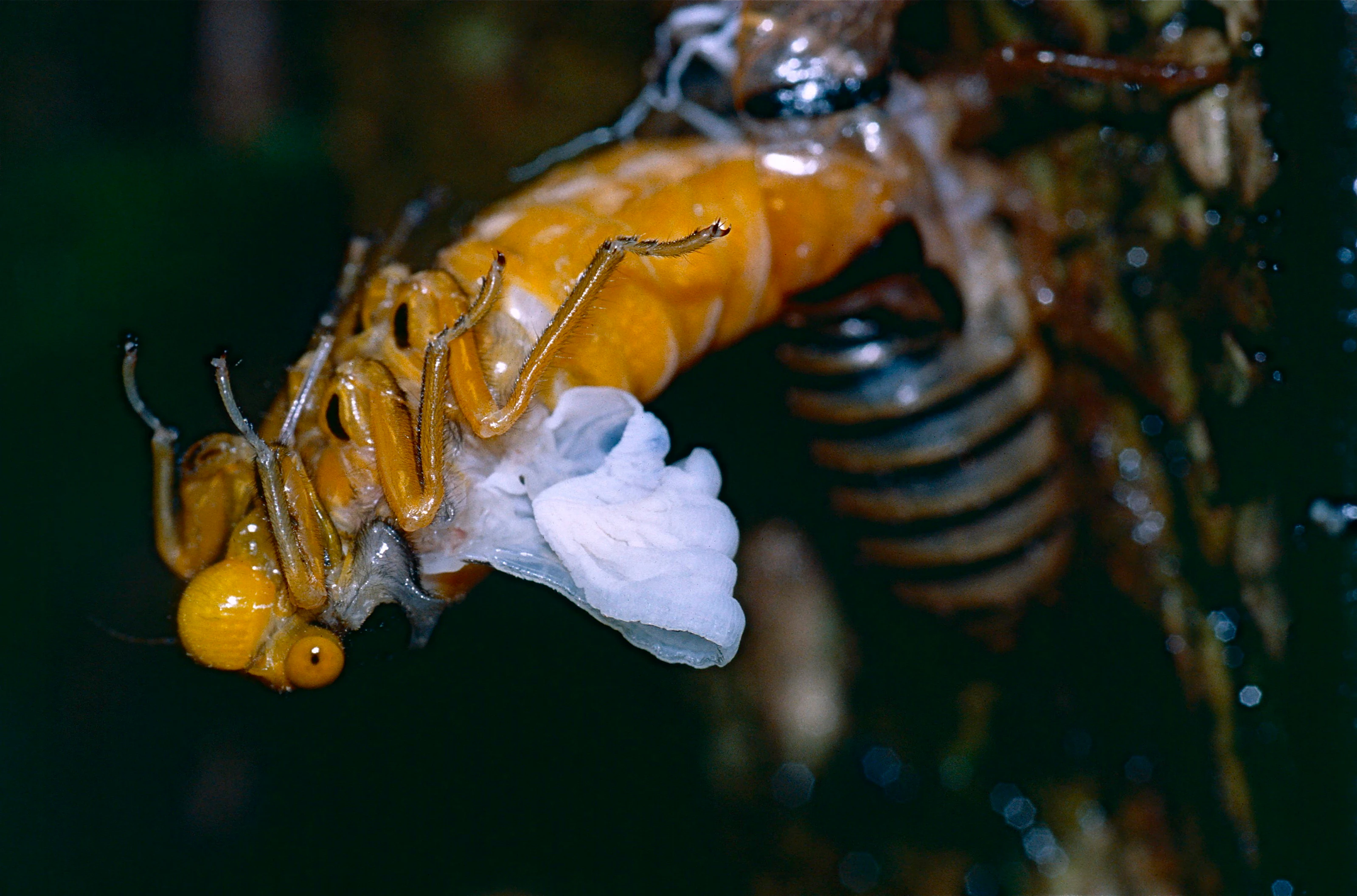
A bright yellow, newly emerged cicada pulling itself out of its empty brown nymph shell attached to a tree bark.
A cicada emerging from its nymph exoskeleton at night.

Best time to visit Kinabalu Park

Kinabalu Park can be visited across much of the year, but conditions on Mount Kinabalu and the surrounding trails vary with the regional climate. The driest period generally offers clearer views from the summit and more comfortable climbing conditions, while the wetter months bring heavier rainfall, mistier mountain conditions, and lusher, greener vegetation throughout the park's forests.

Because the park spans a wide range of elevations, conditions can differ significantly between the lower forest zones and the higher mountain areas at any given time. Most visitors plan climbs to the summit during the drier months when trails are safer and mountain views are more rewarding, while visits focused on the lower park, botanical garden areas, and forest trails can be rewarding throughout much of the year. The cooler temperatures at the high-elevation headquarters and along the climbing routes also offer a distinctive experience compared to typical lowland Sabah weather.
Monthly climate preview

Long-term monthly temperature averages and precipitation patterns for Sabah

Kinabalu Park Climate Normals, Annual Temperature and Precipitation Rhythm

Representative coordinate records show measured monthly temperature variations alongside shifting precipitation rates across the year at Kinabalu Park. Examining the comprehensive twelve-month climate profile reveals detailed thermal ranges and multi-month precipitation cycles.
Annual mean24 °C
23 °C24 °C
Jan23°
Feb23°
Mar23°
Apr24°
May24°
Jun24°
Jul24°
Aug24°
Sep24°
Oct24°
Nov24°
Dec23°
Warmest month
May

24.4 °C

Coolest month
January

22.8 °C

Wettest month
October

11.4 mm/day

Driest month
April

4.8 mm/day

Park location guide

Geography guide, regional context, and park location map for Kinabalu Park

Kinabalu Park park geography, regions, and map view in Malaysia

Understand where Kinabalu Park sits in Malaysia through a broader geographic reading of the surrounding landscape, nearby location context, and its mapped position within the national park landscape.

How Kinabalu Park fits into Malaysia

Malaysia is a federal constitutional monarchy located in Southeast Asia. The country consists of 13 states and three federal territories, divided by the South China Sea into Peninsular Malaysia on the Indochinese Peninsula and East Malaysia on the island of Borneo. With a population of over 34 million, it achieved independence from Britain in 1957 and became a modern federation in 1963. The country is recognized for its multicultural population, tropical climate, and significant economic role in the region.

Wider geography shaping Kinabalu Park in Malaysia

Malaysia occupies a strategic position in Southeast Asia, split by the South China Sea into two distinct regions. Peninsular Malaysia lies on the Indochinese Peninsula, sharing a land border with Thailand to the north and maritime borders with Singapore, Vietnam, and Indonesia. East Malaysia occupies the northern portion of Borneo, sharing land borders with Brunei and Indonesia, and maritime borders with the Philippines and Vietnam. The country's terrain includes coastal plains, mountain ranges such as the Titiwangsa in the peninsula, and extensive tropical rainforests.

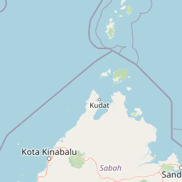
Map view of Kinabalu Park

Use this park location map to pinpoint Kinabalu Park in Malaysia, understand its exact geographic position, and read its mapped placement within the surrounding landscape more clearly.

Pigeon | © OpenStreetMap contributors

Location context for Kinabalu Park

Sabah

Explore photographic records of high mountain terrain, cloud forests, and alpine habitats.

Kinabalu Park Photos and Landscape Scenery: Visualizing the Protected Mountain Environment

Visual documentation captures the dramatic elevation changes, deep ravines, and diverse botanical zones spanning the protected landscape. Examining these field photographs reveals the distinctive geological character and ecological transitions of the Malaysian Borneo reserve.

A brown Ochraceous Bulbul bird with a distinctive white throat and small crest perched on a moss-covered branch against a blurred green forest background.

Close-up profile view of a green Kinabalu crested dragon showing its spiky crest and textured scales while perched on a mossy surface.

A small green tree frog with large orange eyes perched on the edge of a broad dark green leaf against a black background.

A wide shot of the rugged, rocky peaks of Mount Kinabalu rising above a dense, sunlit tropical forest canopy.

A white multi-story building sits at the base of steep rocky mountain peaks with a red sign labeled PANALABAN nearby.

A flowering red bush stands on the granite rock surface near the summit of Mount Kinabalu, with two hikers walking in the distance and a sea of clouds visible below.

A close-up view of an orb web spider viewed from beneath, showing its yellow and black patterned abdomen, centered on a delicate spider web against a dark, out-of-focus forest background.

A bright yellow, newly emerged cicada pulling itself out of its empty brown nymph shell attached to a tree bark.

A brown squirrel perched on a tree branch in a forest setting, eating a small object held in its paws.

A view of the Kinabalu Park headquarters building, characterized by its traditional-style red roof, with several parked vehicles in the foreground and tall green trees in the background.

Park atlas

Compare regional mountain terrain and connected protected landscapes in Borneo

Explore Other Parks Near Kinabalu Park and Protected Areas Across Sabah

Browse nearby national parks and protected areas in the surrounding region to compare regional mountain topography and forest habitats. Extending the search beyond Kinabalu Park reveals wider ecological patterns across Malaysian Borneo.
National parkMalaysia
Mapped park locations coincide#1 closest

Kinabalu National Park: Mapped Boundaries and Protected Landscape Atlas

Exploring Malaysia's Natural Terrain and Park Geography

Delve into the specific protected area identity of Kinabalu National Park, situated within Malaysia. This resource details its geographic scope and mapped terrain, providing a foundation for understanding its role as a national park. Examine the park's protected landscape context, offering valuable insights for anyone exploring regional geography and conservation areas through an atlas lens.

Area
754 km²
Established
1964
IUCN
II
Visitors
611.6K annual
Nature reserveSabah
About 65 km away#2 closest

West

Kota Kinabalu Wetland Centre: Protected Mangrove Landscapes in Sabah, Malaysia

An urban nature reserve and critical coastal wetland site

The Kota Kinabalu Wetland Centre stands as a preserved coastal mangrove fragment within the urban sprawl of Sabah's capital. This nature reserve provides a vital link between land and sea, offering a 1.5-kilometre boardwalk that allows for the observation of migratory bird populations and tidal mudflat ecosystems. As a designated Ramsar wetland, the site demonstrates the importance of small-scale conservation within fast-growing regional capital cities.

Area
0.24 km²
Established
1986
Relief
Lowland
Climate
Tropical
National parkSabah
About 75 km away#3 closest

West

Tunku Abdul Rahman National Park: Sabah National Park Protected Landscape & Geography

Explore mapped boundaries and regional context.

Tunku Abdul Rahman National Park, designated as a national park, offers a specific focus on protected landscape exploration within Sabah. This entity details its geographic footprint and its significance as a mapped natural area. Understanding its role within the regional geography allows for a more complete exploration of Malaysia's protected lands through an atlas perspective.

Area
49 km²
Established
1974
IUCN
II
Relief
Mixed relief
National parkMalaysia
About 91 km away#4 closest

Southwest

Crocker Range National Park: A Protected Landscape within Malaysia's Borneo Region

Mapped boundaries and regional geography context for exploration.

Crocker Range National Park represents a significant protected area within Malaysia, contributing distinct geographic features and landscape context to the Borneo region. This detailed view supports atlas exploration by outlining the park's mapped boundaries and its role within the nation's protected lands. Understand the park's specific location and geographic identity, enriching your comprehension of Malaysian natural landscapes and conservation areas.

Area
1,399 km²
Established
1984
IUCN
II
Relief
Mountain
National parkMalaysia
About 121 km away#5 closest

Southwest

Pulau Tiga National Park: A Protected Landscape within Malaysia's Geographic Context

Discover its mapped boundaries and regional natural terrain.

Pulau Tiga National Park stands as a distinct protected area, offering valuable insights into Malaysia's varied geography. This detail page is designed for structured discovery, highlighting the park's specific mapped boundaries and its contribution to the regional landscape context. Users exploring this national park will find a focused entry into understanding its protected status and its place within the atlas of Southeast Asian natural wonders.

National parkSabah
About 121 km away#6 closest

Southwest

Tiga Island National Park: Geological Mapping and Protected Coastal Landscapes in Sabah

A marine protected area shaped by mud volcano activity

This park encompasses three distinct islands created by mud volcanic eruptions in the South China Sea. Featuring a unique combination of soft, water-saturated terrain, white sandbars, and rocky outcrops, the area offers a compelling look at dynamic coastal geography. The marine environment supports extensive coral reefs and shoals, making the protected zone a key example of geological and marine diversity within the Sabah region.

Area
158 km²
Established
1978
IUCN
II
Relief
Lowland
Marine protected areaSabah
About 134 km away#7 closest

Northeast

Tun Mustapha Marine Park: Mapping the Protected Marine Landscapes of Northern Sabah, Malaysia

An expansive marine protected area across fifty islands

Tun Mustapha Marine Park represents a major conservation landmark off the northern coast of Borneo. This profile details the park's geographic layout, its primary island groups including Banggi and Balambangan, and its position as a critical corridor for marine megafauna and coral reef biodiversity within the Sulu-Sulawesi ecoregion.

Area
8,988 km²
Established
2016
IUCN
II
Relief
Lowland
Nature reserveSabah
About 149 km away#8 closest

South

Maliau Basin Nature Reserve: Geographic Overview and Protected Landscape Mapping

Sandstone escarpments and river drainage in Sabah, Malaysia

Explore the structural geography of Maliau Basin, a prominent nature reserve in Sabah. This protected area is defined by its massive sandstone depression, multi-tiered waterfalls, and expansive primary forest coverage. Examine the watershed dynamics of the Maliau River and the mountainous terrain that isolates this significant wilderness from surrounding lowland regions.

Area
588 km²
Established
1981
IUCN
Ia
Water
Major water bodies

Common questions about visiting, size, designation, and location context for Kinabalu Park

Kinabalu Park FAQs for park facts, access, geography, and protected area context

Find quick answers about Kinabalu Park, including protected-area facts, park geography, trail and visitor context, and how the park fits into its surrounding country and regional landscape.
MoriAtlas Explorer

Continue Your Protected Areas Search Across the Global Atlas

Deepen your exploration by continuing the structured search for national parks and protected areas worldwide. Utilize the comprehensive filtering capabilities to compare different conservation landscapes and refine your understanding of global park geography. Discover more about the distribution and characteristics of protected natural areas.

Global natural geography