Mountain saddles
Emerald Pass
3,465 m

A comprehensive map-based analysis of landscape features and regional topography
This geographic profile details the physical characteristics of Kings Canyon National Park, spanning 1869.25 square kilometers across Tulare and Fresno counties in California. Examine the mountain relief, including peaks such as Mount Brewer and Tehipite Dome, alongside a vast array of habitats ranging from alpine meadows to Mediterranean forest zones.
Related tags
Deep glacial canyons and ancient giant sequoias in California's Sierra Nevada
Kings Canyon National Park is a sprawling wilderness preserve in the southern Sierra Nevada of California, spanning over 461,000 acres across Fresno and Tulare Counties. The park is centered on Kings Canyon, a dramatic glacier-carved valley that plunges more than a mile deep, featuring towering granite cliffs, cascading waterfalls, and pristine mountain meadows. Originally established in 1890 as General Grant National Park to protect a small grove of giant sequoia trees, the park was significantly expanded and renamed in 1940 to encompass the rugged backcountry and the stunning eastern canyon country. Kings Canyon shares a northern boundary with Sequoia National Park, and the two parks are jointly managed by the National Park Service as one unified unit. The park encompasses some of the steepest vertical relief in North America, with peaks exceeding 14,000 feet rising from valley floors at just 4,500 feet, creating a landscape of extraordinary topographic diversity.
Administrative boundaries in California, Fresno, and Tulare Counties
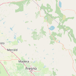
Analyzed territory size, coordinate limits, and mapped park geometry
Explore recorded vertical relief ranges and prominent peaks within the park boundary.
Mountain saddles
3,465 m
Mountain saddles
3,182 m
Peaks
3,838 m
Lakes
Streams
Lakes
Interpreting mountain relief, forest cover, and Mediterranean climate zones
Valleys · Glacier · Mountains · Grassland · Rivers · Forest · Woodland · Cliffs · Lakes · Waterfalls · Cave
Shrubland · Montane forest · Temperate coniferous forest · Alpine meadow · Tundra habitat · Lacustrine habitat · Wetland · Riverine habitat · Glacial habitat · Karst habitat
Explore the Sierra Nevada's Glacial Valleys, Giant Sequoias, and Mountain Protected Landscapes for Comparative Park Discovery

North

High altitude wilderness and volcanic terrain in Eastern California
Spanning from the arid Owens Valley floor to the 14,000 foot crest of the Sierra Nevada, Inyo National Forest remains a cornerstone of the American West. This protected landscape contains the Ancient Bristlecone Pine Forest, Mount Whitney, and the Mono Inyo volcanic chain, providing a dense geographic record of glacial, tectonic, and ecological diversity across a vast managed corridor.
South
High-country geography and wilderness boundaries
Jennie Lakes Wilderness offers a distinct look at high Sierra Nevada topography, featuring granite ridges, alpine lakes, and deep canyons. This Tulare County reserve acts as a critical transition zone between adjacent national parks, preserving a diverse mix of subalpine forests and rugged mountain peaks within its 10,500 acre boundary.

Northwest
California wilderness area with glacial basins and granite peaks
John Muir Wilderness represents one of the largest protected high-elevation areas in the contiguous United States. Spanning the Sierra Nevada crest, its granite terrain is sculpted by Pleistocene glaciation into sharp arêtes, deep canyons, and hundreds of alpine lakes. This wilderness serves as a vital geographic anchor for mountain ecosystems, offering an extensive look at the high-country landscape of eastern California.

South
A vast protected landscape spanning 1.1 million acres in California
Spanning Tulare, Kern, and Fresno counties, Sequoia National Forest preserves iconic giant sequoia groves across multiple river watersheds. The terrain features vertical relief exceeding 11,000 feet, showcasing a range of ecosystems from chaparral slopes and coniferous forests to glacial cirques and granite spires located within the southern Sierra Nevada range.
South
Explore mapped boundaries and the terrain of this California protected area.
Gain a structured understanding of Sequoia National Park as a protected landscape, focusing on its mapped geographic boundaries and its context within California. This entry provides foundational data for exploring the park's natural terrain and its role in a broader atlas of conservation lands, ideal for users seeking detailed geographic information.

Northwest
Geography of alpine lakes, conifer forests, and mountain basins
Spanning from 900 to nearly 14,000 feet in elevation, Sierra National Forest protects a massive vertical range of California terrain. Discover its iconic wilderness areas and reservoir-studded landscape, providing a deep look at the geographic connectivity between major national parks in the central Sierra Nevada.
East
View the geographic boundaries and desert terrain.
Access a detailed atlas perspective of Death Valley National Park, a protected national park situated in California. Understand the park's distinct mapped boundaries and its role within the regional geography. This resource highlights the unique desert landscape, offering focused insights into its protected-area identity and natural terrain for geographic discovery.
Northwest
A federally protected wilderness area in Fresno County, California.
Kaiser Wilderness offers a dense collection of signature Sierra Nevada landforms, including granite cliffs, subalpine forests, and high-altitude lakes. This wildlife reserve preserves a rugged, glacier-scoured interior that provides a distinct contrast to the surrounding regional landscape of the Sierra National Forest, making it a critical entity for understanding mid-elevation mountain ecology.
Deepen your understanding of Kings Canyon National Park by examining its precise mapped boundaries and its significant position within the California region. Further atlas exploration will reveal the park's protected landscape characteristics and its contribution to the broader geographic context of the area. This focused discovery is essential for anyone mapping protected lands and understanding the natural atlas.