Mori Atlas logo
Wildlife reserveKisatchie Hills Wilderness

Mapping the backcountry features and upland forest geography of this protected wilderness area.

Kisatchie Hills Wilderness: An Atlas of Rugged Pine-Clad Terrain and Protected Louisiana Landscapes

Kisatchie Hills Wilderness represents a significant shift in the typical Louisiana landscape; it preserves a pocket of rolling, pine-covered hills that contrast sharply with the state's characteristic lowlands and marshes. This protected area offers a distinct geographic profile defined by sandy-bottomed streams, including Bayou Cypre, and an extensive network of trails through upland forest environments. Through this atlas entry, observe the preserved boundaries and terrain features that define this quiet, roadless backcountry destination within the larger national forest system.

wilderness areaupland forestpine foresthiking trailsbackpackingequestrian trails

Kisatchie Hills Wilderness

Wildlife reserve

Park overview

Structured park overview, official facts, and landscape profile for Kisatchie Hills Wilderness

Kisatchie Hills Wilderness park facts, protected area profile, and essential visitor context

Review the core facts for Kisatchie Hills Wilderness, including designation, size, terrain, visitor scale, habitats, and operating context in one park-focused overview.

About Kisatchie Hills Wilderness

Kisatchie Hills Wilderness is a federally designated wilderness tucked within Kisatchie National Forest in central Louisiana. Despite the state's reputation for low, flat terrain, the area preserves a section of more varied topography, with forested hills and ravines that give the region a wilder feel than almost anywhere else nearby. The wilderness covers roughly 8,700 acres and is administered by the U.S. Forest Service under the protections of the National Wilderness Preservation System.

The defining character of the area is the combination of pine-covered uplands and the streams that drain them into the larger Kisatchie landscape. Bayou Cypre, a sand-bottomed stream whose name reflects an older local pronunciation, runs through the wilderness and is fed by numerous smaller tributaries. This network of clear, sandy streams cuts across the hills and creates the small valleys and seeps that shape hiking conditions, moisture patterns, and habitat variety in the area.

Access to the wilderness is deliberately limited. There are no motorized vehicles permitted, and no developed facilities beyond the trail system, which keeps the landscape feeling remote even though it lies within a national forest that is otherwise used for timber, recreation, and other multiple-use management. The Backbone Trail, the primary route, runs about 7 miles through the heart of the wilderness, with two shorter spur trails branching off it. Hikers and equestrians who complete the full loop or out-and-back must wade across Bayou Cypre, an experience that has become part of the area's identity.

Because Louisiana contains relatively little designated wilderness, Kisatchie Hills Wilderness plays an outsized role in offering backcountry solitude within the state. Visitors come for day hikes along the Backbone Trail, overnight backpacking trips in the more remote sections, and the experience of walking through forest on rolling terrain that is otherwise hard to find this far south in the United States.

Quick facts and research context for Kisatchie Hills Wilderness

Kisatchie Hills Wilderness is a federally designated wilderness area of approximately 8,700 acres inside Kisatchie National Forest in central Louisiana. Established in 1980 and managed by the U.S. Forest Service, it is classified under IUCN category Ib, recognizing it as a protected area managed mainly for wilderness character. The area is closed to motor vehicles and remains undeveloped apart from its trail system, allowing its forest, hills, and streams to dominate the visitor experience.

Protection and recognition

Terrestrial protected area records and establishment chronology for 1980

Kisatchie Hills Wilderness Protection Status and Designation History

Established as a terrestrial protected area in 1980, Kisatchie Hills Wilderness maintains documented conservation boundaries and official management records. Core designation history and recognition details provide structured insight into the protected landscape without external program claims.

Protection details

Protection scope
Terrestrial
Designated year
1980
Transboundary protection
No
Park context

Deeper park guide and search-rich context for Kisatchie Hills Wilderness

Kisatchie Hills Wilderness history, landscape, wildlife, and travel context

Explore Kisatchie Hills Wilderness through its history, landscape character, ecosystems, wildlife, conservation priorities, cultural context, and seasonal travel timing in a structured park guide built for atlas discovery and search intent.

Why Kisatchie Hills Wilderness stands out

Kisatchie Hills Wilderness is best known for being a pocket of unusually rugged terrain within Louisiana, a state most often associated with flat lowlands, marshes, and river systems. The area stands out for its rolling, forested hills and its preserved backcountry character in a region where true wilderness is scarce. It is also recognized for the Backbone Trail, a roughly 7-mile foot and horse route that traces the central spine of the wilderness and connects with shorter spur trails along the way. The presence of Bayou Cypre, a clear, sand-bottomed stream crossed within the trail route, gives the area a distinctive hydrological feature that visitors remember as part of the wilderness experience.

Kisatchie Hills Wilderness history and protected-area timeline

Kisatchie Hills Wilderness was formally established in 1980 as part of the National Wilderness Preservation System, giving it long-term federal protection as a designated wilderness area. Its inclusion within Kisatchie National Forest placed it under the management of the U.S. Forest Service, which has overseen the area through the broader multiple-use framework of the surrounding forest while applying the stricter protections reserved for wilderness.

The wilderness designation marked a recognition that this pocket of Louisiana contained terrain and ecological value worth preserving in a more restrictive manner than the rest of the national forest. Since that time, the area has remained undeveloped apart from its trail system, and motor vehicle use has been excluded, allowing the forest, hills, and streams to retain a backcountry character that increasingly distinguishes it from more heavily managed landscapes elsewhere in the state.

Kisatchie Hills Wilderness landscape and geographic character

The landscape of Kisatchie Hills Wilderness is shaped by a stretch of unusually hilly, forested terrain that contrasts with the broader geography of Louisiana. Rather than the low, marshy coastal plain that dominates much of the state, the wilderness features elevated ground covered in pine and mixed hardwood forest, with ravines and hollows cut by the streams that drain into Bayou Cypre.

The result is a small but distinct region of rolling hills, sandy soils, and clear-flowing streams. The sandy character of Bayou Cypre's bottom is part of what gives the area its backcountry feel, and the network of tributary streams helps create the moist conditions and varied microhabitats found along the trail system.

Kisatchie Hills Wilderness ecosystems, habitats, and plant life

Ecologically, Kisatchie Hills Wilderness represents a relatively uncommon upland forest environment in central Louisiana. Its combination of pine-dominated slopes, hardwood draws, and clear, sand-bottomed streams supports a mix of plant communities that differ from the bottomland hardwoods, cypress swamps, and open marsh typical of the wider region.

The streams that feed Bayou Cypre sustain moist conditions along their banks, while the drier hilltops and ridges carry more drought-tolerant vegetation. This gradient across a small area gives the wilderness a varied habitat structure that supports both forest wildlife and the aquatic life of the streams.

Kisatchie Hills Wilderness wildlife and species highlights

The combination of forested hills and clear streams gives Kisatchie Hills Wilderness habitat for a typical community of Louisiana forest wildlife, with species associated with upland pine and hardwood cover as well as animals drawn to the stream corridors. The undeveloped character of the area, free from vehicle traffic and most forms of heavy infrastructure, makes it a relatively quiet refuge for wildlife behavior within an otherwise managed forest landscape.

The presence of clear, sand-bottomed streams like Bayou Cypre adds a freshwater element to the habitat mix, supporting aquatic and semi-aquatic species along with the broader forest fauna found throughout Kisatchie National Forest.

Kisatchie Hills Wilderness conservation status and protection priorities

Kisatchie Hills Wilderness is significant from a conservation standpoint because it protects a stretch of upland, forested terrain that is rare within Louisiana. Its designation in 1980 under the National Wilderness Preservation System placed it in the most restrictive category of federal land protection, limiting development, motor vehicle use, and most forms of active resource extraction.

Within the larger context of Kisatchie National Forest, where timber management and other uses occur across most of the landscape, the wilderness functions as a preserved core. This role is especially meaningful in a state where formally designated wilderness areas are few, and where most of the land is privately owned or managed for multiple uses.

Top sights and standout views in Kisatchie Hills Wilderness

Kisatchie Hills Wilderness stands out for offering one of the few backcountry hiking experiences in Louisiana, in a state better known for bayous, wetlands, and open lowlands. Its rugged little ridge system, traversed by the Backbone Trail, gives visitors an unusual sense of elevation and forest enclosure.

The wilderness is also notable for the way it integrates trail travel with stream crossings, particularly the wade across Bayou Cypre, which adds a hands-on element to the route. Combined with its protected status inside Kisatchie National Forest, the area offers a concentrated experience of Louisiana's less familiar upland nature.

Best time to visit Kisatchie Hills Wilderness

The most comfortable conditions for hiking and backpacking in Kisatchie Hills Wilderness generally fall during the cooler and drier portions of the year, when the trails are firmer and the heat and humidity of the Louisiana climate are reduced. Spring and fall bring milder temperatures and active forest conditions, while summer visits are possible but typically more demanding due to heat, humidity, and heavier insect presence along the streams. Because the area depends on stream wades and lower-lying sections of trail, visitors should be prepared for wet footing at any time of year.

Monthly climate preview

Long-term temperature ranges and daily precipitation patterns across the year

Kisatchie Hills Wilderness Climate Normals and Monthly Weather Statistics

Historical measurements from a representative coordinate outline the measured annual temperature progression and monthly precipitation rates for Kisatchie Hills Wilderness. Analyzing the complete twelve-month climatology profile provides deeper context on long-term regional weather variations.
Annual mean19 °C
8 °C29 °C
Jan
Feb11°
Mar15°
Apr19°
May23°
Jun27°
Jul28°
Aug29°
Sep25°
Oct20°
Nov13°
Dec
Warmest month
August

28.6 °C

Coolest month
January

8.3 °C

Wettest month
December

4.5 mm/day

Driest month
August

3.3 mm/day

Park location guide

Geography guide, regional context, and park location map for Kisatchie Hills Wilderness

Kisatchie Hills Wilderness park geography, regions, and map view in United States of America

Understand where Kisatchie Hills Wilderness sits in United States of America through a broader geographic reading of the surrounding landscape, nearby location context, and its mapped position within the national park landscape.

How Kisatchie Hills Wilderness fits into United States of America

The United States of America is a federal presidential republic and one of the world's largest countries by area and population. It consists of 50 states across a vast territory spanning multiple time zones, with its capital in Washington, D.C. and largest city in New York City. The nation has a diverse economy, influential political system, and significant cultural and military presence globally.

Wider geography shaping Kisatchie Hills Wilderness in United States of America

The United States occupies a vast territory in North America, bordered by Canada to the north and Mexico to the south. The 48 contiguous states stretch from the Atlantic to the Pacific Ocean, while Alaska occupies the northwestern region and Hawaii is an archipelago in the Pacific. The country encompasses diverse terrain including the Rocky Mountains, Appalachian Mountains, Great Plains, and extensive river systems.

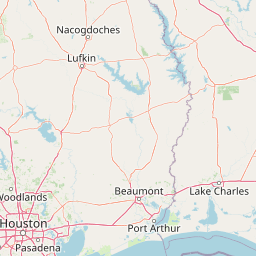
Map view of Kisatchie Hills Wilderness

Use this park location map to pinpoint Kisatchie Hills Wilderness in United States of America, understand its exact geographic position, and read its mapped placement within the surrounding landscape more clearly.

Pigeon | © OpenStreetMap contributors

Location context for Kisatchie Hills Wilderness

Louisiana
Park atlas

Compare regional forest reserves, upland wilderness, and nearby protected natural areas

Parks Near Kisatchie Hills Wilderness and Surrounding Protected Landscapes

Browse other parks near Kisatchie Hills Wilderness to compare rugged upland pine terrain and remote forest reserves across the surrounding regional geography. Examining adjacent protected areas provides broader context for understanding rare southern wilderness tracts and diverse woodland habitats.
National parkLouisiana
About 15 km away#1 closest

West

Kisatchie National Forest: Geographic Overview and Protected Landscapes in Louisiana

Mapping the state's largest expanse of protected forest and pine ecosystems.

Spanning over 600,000 acres, Kisatchie National Forest stands as the primary protected natural landscape within Louisiana. Its terrain ranges from ancient upland pine formations and sandstone ridges to complex hardwood bottoms and cypress-tupelo swamps. This area serves as a vital anchor for regional biodiversity, protecting rare hillside seepage bogs and calcareous prairies that have largely vanished from the surrounding southern landscape.

Area
2,440 km²
Established
1930
Relief
Upland
Climate
Subtropical
Protected landscapeMississippi
154 km away#2 closest

East

Homochitto National Forest: Mapping the Protected Landscapes of Southwestern Mississippi

Regional forest geography and landscape documentation.

Investigate the unique landscape of Homochitto National Forest, an extensive protected area in Mississippi defined by its loess-country topography and managed pine forests. This entry provides essential mapping context and geographic data for those examining the role of this forest within the broader Southeastern United States ecological network and its CCC-rooted heritage.

Area
776.34 km²
Established
1936
Relief
Upland
Scope
Terrestrial
A pale, minimalist watercolor painting showing a soft green treeline and forest edge against a white background.
Protected landscapeTexas
222 km away#3 closest

Southwest

Sam Houston National Forest: Mapping the Piney Woods Protected Landscape

Regional Geography of East Texas Protected Lands

Sam Houston National Forest is a 163,000-acre protected area in East Texas characterized by loblolly and shortleaf pine ridges. The geography features an intricate network of creeks, hardwood bottomlands, and designated wilderness areas like Little Lake Creek. Framed by Lake Conroe and Lake Livingston, the forest offers a complex look at Gulf Coastal Plains topography and long-standing Piney Woods ecological restoration efforts.

Area
659.82 km²
Established
1936
Relief
Lowland
Climate
Subtropical
Watercolor painting of a forested landscape with soft rolling mountains in the background and vegetation in the foreground.
Protected landscapeArkansas
280 km away#4 closest

North

Ouachita National Forest: Protected Landscape and Mountain Geography in Arkansas

Exploring the ancient ridges and river corridors of the Ouachita Mountains

Ouachita National Forest protects a unique geological system of east-west folded ridges and sandstone bluffs in the interior United States. This expansive region provides vital habitats for diverse hardwood communities and hosts extensive wilderness areas, offering a deep look into the natural history and terrain of the Ouachita Mountain range within Arkansas.

Area
7,221.44 km²
Established
1907
IUCN
VI
Relief
Mountain
National parkGarland County
329 km away#5 closest

North

Hot Springs National Park: National Park Protected Area and Geographic Context

Mapped boundaries and regional landscape of this US National Park.

Gain a structured understanding of Hot Springs National Park, focusing on its identity as a protected national park. Examine its mapped geography and regional landscape context within Garland County, providing essential details for atlas-based exploration. This entry details the park's protected area and its position in the broader geographic framework.

Area
22.5 km²
Established
1832
IUCN
II
Visitors
2.6M annual
Protected areaTexas
349 km away#6 closest

Northwest

Caddo National Grassland: Geographic Overview of a Texas Protected Area

Restored prairie and oak savanna in Fannin County

Located in northeastern Texas, Caddo National Grassland encompasses roughly 17,873 acres across two distinct units. The park illustrates a successful shift from eroded agricultural land to a protected mosaic of native grasses, hardwood stands, and aquatic corridors anchored by Lake Davy Crockett, providing a clear window into the recovery of the southern Great Plains.

Area
72.33 km²
Established
1930
Relief
Lowland
Climate
Temperate
A horizontal watercolor painting showing rolling green hills and a small stream in the foreground with faint mountain ridges in the distance.
Wildlife reserveArkansas
365 km away#7 closest

North

Flatside Wilderness: Rugged Sandstone Ridges in the Ouachita Mountains

Arkansas wildlife reserve featuring mountain summits and mapped backcountry

Flatside Wilderness offers a deep look at the high-relief geography of the Ouachita Mountains. Featuring prominent sandstone summits and an 8.9-mile segment of the Ouachita National Recreation Trail, this protected landscape provides essential insight into the state's wilderness systems and regional forest ecosystems.

Area
38.47 km²
Established
1984
IUCN
Ib
Marine protected areaTexas
386 km away#8 closest

South

Flower Garden Banks National Marine Sanctuary: Offshore Coral Reefs and Salt Dome Geography

A critical marine protected area landscape in the Gulf of Mexico

Flower Garden Banks National Marine Sanctuary sits roughly 100 nautical miles offshore from the Texas coast, where unique salt dome geology creates elevated ridges that support the northernmost thriving coral reefs in the continental United States. This protected area map highlights the interconnected network of submerged banks and reefs, providing essential habitat for pelagic marine species and rare coral ecosystems in the northwestern Gulf of Mexico.

Area
410 km²
Established
1992
Scope
Marine
Water
Water-dominated

Common questions about visiting, size, designation, and location context for Kisatchie Hills Wilderness

Kisatchie Hills Wilderness FAQs for park facts, access, geography, and protected area context

Find quick answers about Kisatchie Hills Wilderness, including protected-area facts, park geography, trail and visitor context, and how the park fits into its surrounding country and regional landscape.
MoriAtlas Explorer

Continue Your Protected Areas Search Across the Global Atlas

Deepen your exploration by continuing the structured search for national parks and protected areas worldwide. Utilize the comprehensive filtering capabilities to compare different conservation landscapes and refine your understanding of global park geography. Discover more about the distribution and characteristics of protected natural areas.

Global natural geography