Mori Atlas logo
National parkKisatchie National Forest

Analyzing the diverse upland pine forests, river corridors, and rare hillside seepage bogs.

Kisatchie National Forest: Mapped Geography and Protected Landscapes in Central Louisiana

Kisatchie National Forest represents a primary protected area across central and northern Louisiana, encompassing over 600,000 acres of managed public land. This extensive forest preserves critical longleaf pine and flatwood ecosystems within the Cenozoic uplands, offering a unique look at the geological and natural heritage of the Gulf coastal plain. Beyond the expansive pine ridges, the landscape includes hardwood bottoms, clear bayou systems, and small calcareous prairie remnants that define this significant regional wilderness.

national forestlongleaf pineflatwoodspiney hillshardwood bottomsrare habitats

Kisatchie National Forest

National park

Park overview

Structured park overview, official facts, and landscape profile for Kisatchie National Forest

Kisatchie National Forest park facts, protected area profile, and essential visitor context

Review the core facts for Kisatchie National Forest, including designation, size, terrain, visitor scale, habitats, and operating context in one park-focused overview.

About Kisatchie National Forest

Kisatchie National Forest is the only federally designated National Forest in Louisiana, sitting within a region of long, gently rolling piney hills and hardwood bottoms that distinguish central and northern parishes from the coastal wetlands elsewhere in the state. The forest stretches across hundreds of thousands of acres of public land, structured into five ranger districts: Calcasieu, Caney, Catahoula, Kisatchie, and Winn. Much of this landscape is part of the Cenozoic uplands, among the older rock formations in Louisiana, giving it a terrain and soil profile very different from the alluvial delta country to the south.

What truly defines Kisatchie is its longleaf pine ecosystem. More than half of the forest's acreage consists of longleaf pine and associated flatwoods, a fire-dependent habitat that has been reduced to a small fraction of its original extent across the South. Within these woodlands are rare communities that lend the forest its ecological weight: hillside seepage bogs fed by ground water, calcareous prairies clinging to limestone-influenced soils, and hardwood sloughs along bayous and river corridors. Each of these habitats supports plant and animal assemblages that exist nowhere else in the state, including wild orchids and carnivorous plants such as the pale pitcher plant and the rose pogonia.

The forest also plays a major role in conserving biodiversity of the Gulf coastal plain. The Kisatchie Hills Wilderness, embedded within the forest, is a nationally designated wilderness area; the surrounding Red Dirt National Wildlife Management Preserve expands protection for sensitive species. Cypress-tupelo swamps such as Cunningham Brake anchor the wetland end of the habitat spectrum, while Saline Bayou, designated as part of the National Wild and Scenic Rivers system, lines its quiet waters with bald cypress and other hardwoods. The roadless areas of the forest have been established to shield amphibian and reptile populations from fragmentation and to protect native flora in their most intact settings.

Recreation is woven deeply into how the public encounters Kisatchie. More than one hundred miles of trails serve hikers, mountain bikers, and horseback riders, and over forty developed recreation sites provide camping, boating, swimming, picnicking, and wildlife viewing opportunities. Notable destinations include Kisatchie Bayou with its clear swimming holes and rare Louisiana waterfalls, the Longleaf Vista Recreation Area with sandstone bluffs, the Wild Azalea National Recreation Trail, and Sugar Cane National Recreation Trail. The forest also accommodates cultural and historical interpretation through the Kisatchie National Forest Heritage Program, which protects archaeological sites and surviving Civilian Conservation Corps structures from the 1930s and 1940s.

Quick facts and research context for Kisatchie National Forest

Kisatchie National Forest is the only National Forest in Louisiana and is administered by the United States Forest Service across five ranger districts headquartered in Pineville. Its roughly 604,000 acres are concentrated in seven parishes of central and northern Louisiana, and more than half of its land supports longleaf pine and flatwoods vegetation. The forest protects examples of the South Central Plains Ecoregion, includes the Kisatchie Hills Wilderness, and hosts rare habitats such as hillside seepage bogs and calcareous prairies. It was designated on June 10, 1930, during the administration of President Herbert Hoover, and its name traces back to the Kichai tribe of the Caddo Confederacy.

Protection and recognition

Documented protection history, management mandates, and recognized conservation frameworks

Kisatchie National Forest Protection Status and Terrestrial Conservation Scope

Kisatchie National Forest maintains a documented terrestrial protection scope detailing its official designation and administrative framework. Structured conservation records outline the governing parameters and management classifications established for the terrain.

Protection details

Protection scope
Terrestrial
Transboundary protection
No
Park context

Deeper park guide and search-rich context for Kisatchie National Forest

Kisatchie National Forest history, landscape, wildlife, and travel context

Explore Kisatchie National Forest through its history, landscape character, ecosystems, wildlife, conservation priorities, cultural context, and seasonal travel timing in a structured park guide built for atlas discovery and search intent.

Why Kisatchie National Forest stands out

Kisatchie National Forest is best known for its vast longleaf pine forests and flatwoods, an ecosystem that once covered much of the American South but has dramatically declined across the region. It is also recognized for protecting rare ecological features like hillside seepage bogs, calcareous prairies, cypress-tupelo swamps, and the Kisatchie Hills Wilderness. Wildlife significance further defines the forest, with the red-cockaded woodpecker, Louisiana pine snake, Louisiana black bear, and Louisiana pearlshell among the rare species that depend on its habitats.
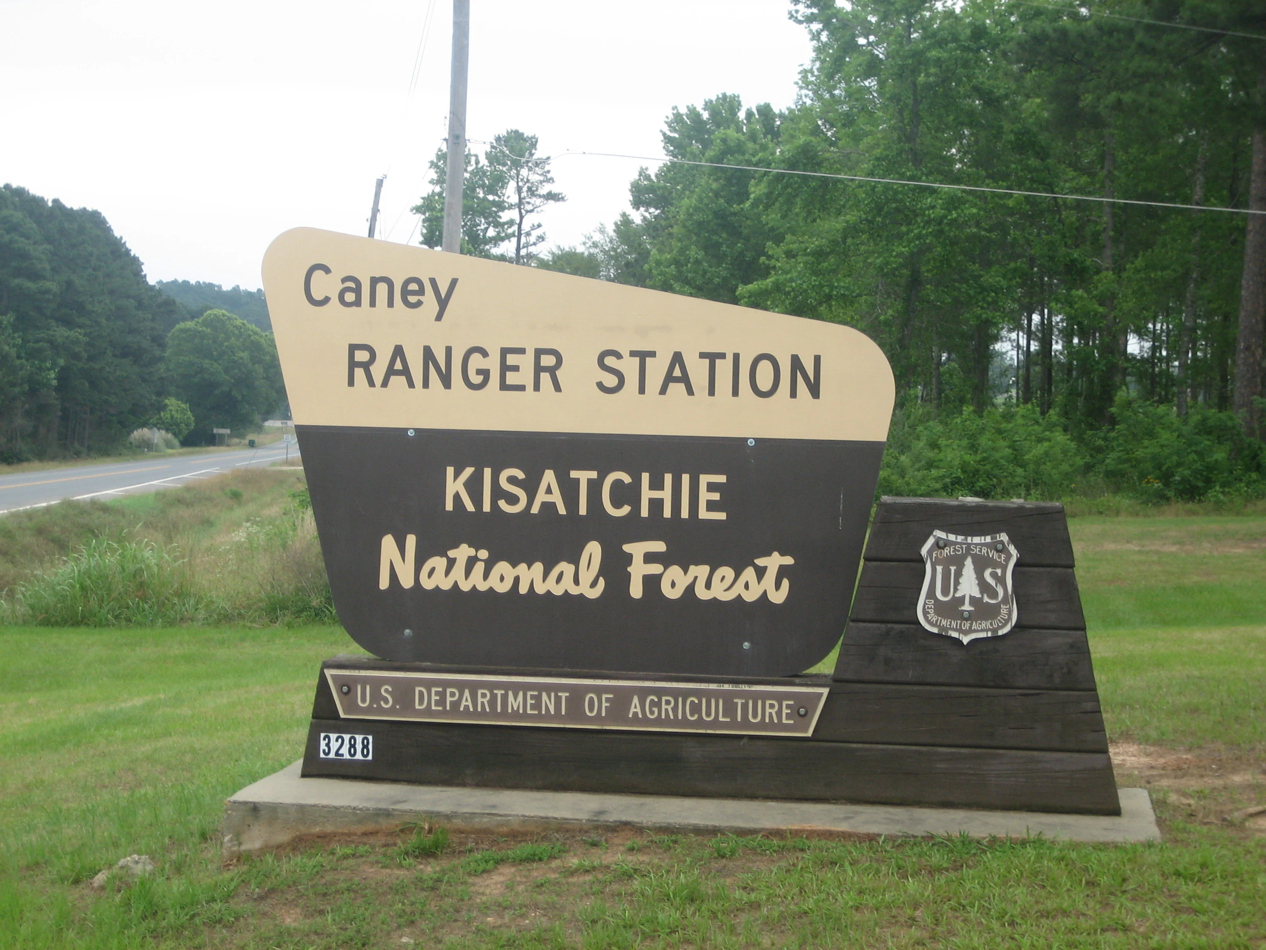
A brown and cream-colored entrance sign for the Caney Ranger Station in Kisatchie National Forest, featuring the U.S. Forest Service logo.
The entrance sign for the Caney Ranger Station in Kisatchie National Forest.

Kisatchie National Forest history and protected-area timeline

Kisatchie National Forest was formally designated on June 10, 1930, during the administration of U.S. President Herbert Hoover, becoming the only National Forest in Louisiana. Its name is taken from the Kichai tribe of the Caddo Confederacy, the Indigenous peoples who lived in the region long before European settlement.

The creation of the forest built on decades of unregulated harvesting that had dramatically transformed the longleaf pine landscape of central and northern Louisiana. Work by the Civilian Conservation Corps in the 1930s helped rehabilitate cleared lands and shaped much of the early infrastructure still in use today. The Stuart Seed Orchard was built during this era to support replanting of cut-over areas, and the resulting Stuart Lake Recreation Complex emerged as a byproduct of the orchard watering system. Other CCC-built sites, including the Gum Springs Recreation Area, remain in use as cultural and recreational landmarks within the forest.

The Caney Ranger District, in the northeastern part of the forest, has a distinct administrative history: it began under the Depression-era Resettlement Administration, which acquired marginal upland farmland, before being transferred to the Forest Service in 1959. The forest was also shaped by World War II-era U.S. Army installations and training operations, with the remains of Camp Claiborne and Camp Livingston still visible in today's landscape; Camp Livingston in particular played a central role in the famed Louisiana Maneuvers of 1940 and 1941 that prepared U.S. forces for the war.

In the late twentieth century, the Forest Service prepared a Final Environmental Impact Statement that highlighted the protection of roadless areas as essential to the forest's biodiversity. Recognition of the forest's broader significance continued into the twenty-first century when, in 2015, the United States Mint issued the Kisatchie National Forest quarter as part of the America the Beautiful Quarters series, featuring a wild turkey in flight over bluestem grass with longleaf pines.

Kisatchie National Forest landscape and geographic character

The terrain of Kisatchie National Forest is shaped by the Cenozoic uplands, some of the oldest exposed formations in Louisiana. Long, gently rolling hills of piney country alternate with broader hardwood bottoms, creating a varied topography that contrasts strongly with the flat coastal plains elsewhere in the state. Sandstone bluffs, ridgelines, and hilly corridors define the more elevated country, particularly around the Kisatchie Hills and along the Longleaf Vista Recreation Area.

Water shapes the forest as well. Kisatchie Bayou drains through a substantial portion of the national forest and is notable for its clear waters, swimming holes, and small waterfalls, including Kisatchie Falls, one of the few waterfalls in the state and home to its only Class II rapids. Saline Bayou winds through the Winn District, lined with bald cypress and hardwoods reflected in its slow-moving water, and approximately twenty-one miles of it are designated as part of the National Wild and Scenic Rivers system. Elsewhere, Fullerton Lake, Kincaid Lake, Valentine Lake, Caney Lakes, Corney Lake, and Stuart Lake punctuate the landscape with reservoirs and recreation complexes.

Wetlands are equally integral to the geography. Large cypress-tupelo gum swamps, including Cunningham Brake along Kisatchie Bayou, hold dark-water environments characteristic of the Gulf coastal plain. Scattered calcareous prairies cling to special soil conditions, while hillside seepage bogs emerge in pockets where groundwater emerges on slopes. The combined effect is a mosaic of upland pine ridges, hardwood flats, river corridors, swamps, and tiny high-value prairie remnants, all of which together define the geography of this forest.

Kisatchie National Forest ecosystems, habitats, and plant life

Kisatchie National Forest is dominated ecologically by the longleaf pine ecosystem, one of the most botanically diverse forest types in North America. More than half of its public land is longleaf pine and associated flatwoods, a community sustained historically by frequent low-intensity fire. Beyond the longleaf canopy, the forest harbors mixed pine-hardwood forests, shortleaf pine woodlands, cypress-tupelo swamps, and alluvial hardwood forests along bayou corridors. These create a gradient of plant communities from dry, sandy ridges to permanently saturated wetland flats.

Rare habitats elevate the conservation importance of the forest. Hillside seepage bogs, fed by groundwater seeping downslope, support unusual assemblages of plants adapted to constantly saturated, acidic, nutrient-poor conditions. Calcareous prairies, found on limestone-influenced soils, contain plant species more typical of grasslands to the west than of Louisiana as a whole. Several small prairie remnants survive within the forest, including the Kieffer Prairie, and historically referenced parcels such as Tancock Prairie and Bartram Prairie, mentioned in nineteenth-century survey records.

The forest also supports exceptional plant diversity in its understory. Carnivorous plants such as the pale pitcher plant have been documented, alongside wild orchids like the rose pogonia. These sensitive species respond strongly to changes in fire frequency, hydrology, and forest management. The combination of fire-maintained pine communities, seepage wetlands, and prairie fragments gives Kisatchie an unusually layered ecological character for a state otherwise known for coastal marsh and bottomland forest.

Kisatchie National Forest wildlife and species highlights

Kisatchie National Forest sustains a rich vertebrate fauna shaped by its longleaf pine and hardwood mosaic. Biologists working in the forest have documented 155 species of breeding or overwintering birds, 48 mammal species, 56 reptile species, and 30 amphibian species across its habitats. The forest's longleaf pine landscape is especially valuable for ground-nesting species, cavity-nesting birds, and a wide variety of reptiles and amphibians tied to fire-maintained open-canopy conditions.

Among the most prominent rare species is the red-cockaded woodpecker, one of the few birds endemic to the United States. The bird's specialized cavity-nesting requirements in mature longleaf pines made it vulnerable to historical deforestation, and many of its surviving colonies in Louisiana are concentrated in the Vernon Unit of the Calcasieu Ranger District, where their habitat boundaries are marked and actively managed. Other rare or sensitive species include the Louisiana pine snake, an indicator species of intact longleaf pine ecosystems, the Louisiana black bear, and the Louisiana pearlshell, a freshwater mussel found in the forest's stream systems.

Wild turkey populations were historically eliminated from large parts of their range but have recovered across the national forest, and they remain both ecologically significant and culturally resonant, recalling their traditional role as a food animal for Native American communities. Bats use the forest in notable numbers, with research in the Palustris Experimental Forest showing that bat occupancy is closely tied to the openness of the forest canopy under different management regimes. Amphibians and reptiles are particularly sensitive to road impacts, and protection of roadless areas is understood as a key strategy for maintaining their populations and the vernal pool habitats many depend on for breeding.

Kisatchie National Forest conservation status and protection priorities

Kisatchie National Forest plays a major role in conserving representative examples of the landscape of northern Louisiana, particularly within the South Central Plains Ecoregion. It serves as one of the largest intact natural landscapes in the state and provides core habitat for species that have lost most of their range elsewhere in the region. As a National Forest, it is a federal anchor for longleaf pine restoration, one of the most pressing ecosystem conservation efforts in the southeastern United States.

Protection of rare habitats is a central conservation focus. Hillside seepage bogs and calcareous prairies comprise a small fraction of the landscape but contain plant species that exist nowhere else in the state. The forest also anchors broader conservation networks: the Kisatchie Hills Wilderness is one of only three designated wilderness areas in Louisiana, the Red Dirt National Wildlife Management Preserve extends protection for sensitive wildlife habitat, and approximately twenty-one miles of Saline Bayou retain their National Wild and Scenic River designation. The roadless areas of Cunningham Brake and Saline Bayou were established specifically to protect native species from fragmentation.

The forest's conservation mission also extends across institutional boundaries. The Louisiana Statewide Red-cockaded Woodpecker Safe Harbor Program connects the Forest Service, the U.S. Fish and Wildlife Service, and the Louisiana Department of Wildlife and Fisheries with private landowners, expanding foraging habitat beyond federal boundaries. Forest research, including bat studies, seed orchard genetics, and experimental forestry at the Palustris Experimental Forest, contributes to broader regional understanding of how to manage fire-dependent forests for both wildlife and timber. Together, these efforts position Kisatchie as both a refuge and a working laboratory for longleaf pine ecosystem conservation.

Kisatchie National Forest cultural meaning and human context

The cultural identity of Kisatchie National Forest is rooted in Indigenous history and the broader heritage of central and northern Louisiana. The forest's name comes from the Kichai, a tribe of the Caddo Confederacy whose presence in the region long predates European settlement. This naming reflects the lasting influence of Native American peoples on the cultural landscape of Louisiana's interior, even as later settlement, agriculture, and timber industries reshaped the land.

The Civilian Conservation Corps left a substantial mark on the forest in the 1930s and 1940s. CCC crews built infrastructure including the Stuart Seed Orchard and the Gum Springs Recreation Area, structures that still anchor recreation in the forest today. The Kisatchie National Forest Heritage Program continues to steward these and other archaeological and historic sites, preserving the built heritage of New Deal era conservation alongside older Indigenous and early European traces of land use.

World War II also imprinted itself on the forest's cultural geography. The former Camp Claiborne, once the largest military installation in the United States and described in its time as the third-largest city in Louisiana, lies partly within the Evangeline Unit, with portions today leased for training. The remains of Camp Livingston, once the epicenter of the 1941 Louisiana Maneuvers that prepared U.S. forces for combat, lie almost entirely within the Catahoula Ranger District. These military legacies are part of the layered cultural context of a forest more commonly experienced for its recreational and natural values.

Top sights and standout views in Kisatchie National Forest

Kisatchie National Forest holds the rare distinction of being Louisiana's only National Forest, and its scale makes it one of the state's largest pieces of natural landscape. Its longleaf pine forests, including substantial flatwoods communities, represent one of the most important remaining strongholds of a declining southern ecosystem. Embedded within it are the Kisatchie Hills Wilderness, Red Dirt National Wildlife Management Preserve, and the National Wild and Scenic portion of Saline Bayou, giving the forest both ecological depth and protected-area recognition.

Equally striking is the diversity of rare habitats rarely associated with Louisiana: hillside seepage bogs, calcareous prairies, cypress-tupelo swamps like Cunningham Brake, and the unusually clear waters and small waterfalls of Kisatchie Bayou. These combine with more than a hundred miles of trail, over forty developed recreation sites, and a strong cultural heritage drawn from the Kichai people, the Civilian Conservation Corps, and World War II training history to give the forest a layered significance that goes well beyond its pine tree identity.

Best time to visit Kisatchie National Forest

Kisatchie National Forest's longleaf pine ecosystem is shaped by fire and seasonal climate, and the most rewarding times to visit tend to align with the milder months. Spring brings wildflowers, blooming orchids, and feeding activity across the understory, while also drawing migratory hummingbirds and seasonal butterflies to flowering sites such as the Catahoula Hummingbird and Butterfly Garden. Fall brings milder temperatures, active wildlife populations including wild turkey, and stable hiking conditions across the forest's trail network.

Summer in Louisiana is hot and humid, and visitors should expect challenging conditions for long hikes, though swimming in bayou waters and boating on forest lakes is most enjoyable in this season. Cooler winter months bring more moderate weather and can be a good time to observe overwintering birds and enjoy quieter trails. Wildlife viewing opportunities are present throughout the year, varying with the breeding, nesting, and migration cycles of the forest's rich bird life.
Monthly climate preview

Long-term temperature and precipitation averages across the representative coordinate

Kisatchie National Forest Climate Normals and Monthly Weather Records

Representative coordinates record measured monthly averages spanning minimums of minus five degrees Celsius to maximums exceeding thirty-nine degrees Celsius alongside steady precipitation. Reviewing twelve-month baseline normals clarifies annual meteorological rhythms and supports thorough climate analysis for Kisatchie National Forest.
Annual mean19 °C
8 °C29 °C
Jan
Feb11°
Mar15°
Apr19°
May23°
Jun27°
Jul28°
Aug29°
Sep25°
Oct20°
Nov13°
Dec
Warmest month
August

28.6 °C

Coolest month
January

8.3 °C

Wettest month
December

4.5 mm/day

Driest month
August

3.3 mm/day

Park location guide

Geography guide, regional context, and park location map for Kisatchie National Forest

Kisatchie National Forest park geography, regions, and map view in United States of America

Understand where Kisatchie National Forest sits in United States of America through a broader geographic reading of the surrounding landscape, nearby location context, and its mapped position within the national park landscape.

How Kisatchie National Forest fits into United States of America

The United States of America is a federal presidential republic and one of the world's largest countries by area and population. It consists of 50 states across a vast territory spanning multiple time zones, with its capital in Washington, D.C. and largest city in New York City. The nation has a diverse economy, influential political system, and significant cultural and military presence globally.

Wider geography shaping Kisatchie National Forest in United States of America

The United States occupies a vast territory in North America, bordered by Canada to the north and Mexico to the south. The 48 contiguous states stretch from the Atlantic to the Pacific Ocean, while Alaska occupies the northwestern region and Hawaii is an archipelago in the Pacific. The country encompasses diverse terrain including the Rocky Mountains, Appalachian Mountains, Great Plains, and extensive river systems.

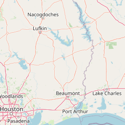
Map view of Kisatchie National Forest

Use this park location map to pinpoint Kisatchie National Forest in United States of America, understand its exact geographic position, and read its mapped placement within the surrounding landscape more clearly.

Pigeon | © OpenStreetMap contributors

Location context for Kisatchie National Forest

Louisiana

Visual reference of longleaf pine hills, bayous, and rare southern habitats

Kisatchie National Forest Photos and Protected Landscape Scenery

Visual records reveal the rolling pine ridges, sandstone bluffs, and dark-water cypress swamps defining Kisatchie National Forest. Examining authentic terrain photography helps researchers understand the rare protected habitats and varied topography shaping this southern conservation landscape.

A brown and cream-colored entrance sign for the Caney Ranger Station in Kisatchie National Forest, featuring the U.S. Forest Service logo.

A brown and white entrance sign for the Kisatchie Ranger Station in Kisatchie National Forest, set on a stone base with a US Forest Service shield logo.

Park atlas

Compare regional park geography, upland pine terrain, and connected southern habitats.

Exploring Parks Near Kisatchie National Forest and Surrounding Protected Landscapes

Visitors exploring Kisatchie National Forest can continue browsing other protected areas and nearby regional parks that share similar southern upland terrain. Comparing adjacent conservation landscapes reveals broader ecological patterns across the surrounding Gulf coastal plain.
Wildlife reserveLouisiana
About 15 km away#1 closest

East

Kisatchie Hills Wilderness: Exploring Louisiana's Rugged Backcountry Protected Landscapes

Upland forest geography and preserved ridge terrain in Louisiana.

Kisatchie Hills Wilderness serves as a rare example of elevated, rugged terrain in Louisiana, offering a protected backcountry environment far removed from coastal marshes. This area provides a specialized map of forest-clad hills, ravines, and clear stream crossings that define a unique regional geography for those tracing Louisiana's diverse natural features.

Area
35.21 km²
Established
1980
IUCN
Ib
Relief
Upland
Protected landscapeMississippi
About 176 km away#2 closest

East

Homochitto National Forest: Mapping the Protected Landscapes of Southwestern Mississippi

Regional forest geography and landscape documentation.

Investigate the unique landscape of Homochitto National Forest, an extensive protected area in Mississippi defined by its loess-country topography and managed pine forests. This entry provides essential mapping context and geographic data for those examining the role of this forest within the broader Southeastern United States ecological network and its CCC-rooted heritage.

Area
776.34 km²
Established
1936
Relief
Upland
Scope
Terrestrial
A pale, minimalist watercolor painting showing a soft green treeline and forest edge against a white background.
Protected landscapeTexas
About 208 km away#3 closest

Southwest

Sam Houston National Forest: Mapping the Piney Woods Protected Landscape

Regional Geography of East Texas Protected Lands

Sam Houston National Forest is a 163,000-acre protected area in East Texas characterized by loblolly and shortleaf pine ridges. The geography features an intricate network of creeks, hardwood bottomlands, and designated wilderness areas like Little Lake Creek. Framed by Lake Conroe and Lake Livingston, the forest offers a complex look at Gulf Coastal Plains topography and long-standing Piney Woods ecological restoration efforts.

Area
659.82 km²
Established
1936
Relief
Lowland
Climate
Subtropical
Watercolor painting of a forested landscape with soft rolling mountains in the background and vegetation in the foreground.
Protected landscapeArkansas
About 277 km away#4 closest

North

Ouachita National Forest: Protected Landscape and Mountain Geography in Arkansas

Exploring the ancient ridges and river corridors of the Ouachita Mountains

Ouachita National Forest protects a unique geological system of east-west folded ridges and sandstone bluffs in the interior United States. This expansive region provides vital habitats for diverse hardwood communities and hosts extensive wilderness areas, offering a deep look into the natural history and terrain of the Ouachita Mountain range within Arkansas.

Area
7,221.44 km²
Established
1907
IUCN
VI
Relief
Mountain
National parkGarland County
About 334 km away#5 closest

North

Hot Springs National Park: National Park Protected Area and Geographic Context

Mapped boundaries and regional landscape of this US National Park.

Gain a structured understanding of Hot Springs National Park, focusing on its identity as a protected national park. Examine its mapped geography and regional landscape context within Garland County, providing essential details for atlas-based exploration. This entry details the park's protected area and its position in the broader geographic framework.

Area
22.5 km²
Established
1832
IUCN
II
Visitors
2.6M annual
Protected areaTexas
About 339 km away#6 closest

Northwest

Caddo National Grassland: Geographic Overview of a Texas Protected Area

Restored prairie and oak savanna in Fannin County

Located in northeastern Texas, Caddo National Grassland encompasses roughly 17,873 acres across two distinct units. The park illustrates a successful shift from eroded agricultural land to a protected mosaic of native grasses, hardwood stands, and aquatic corridors anchored by Lake Davy Crockett, providing a clear window into the recovery of the southern Great Plains.

Area
72.33 km²
Established
1930
Relief
Lowland
Climate
Temperate
A horizontal watercolor painting showing rolling green hills and a small stream in the foreground with faint mountain ridges in the distance.
Wildlife reserveArkansas
About 371 km away#7 closest

North

Flatside Wilderness: Rugged Sandstone Ridges in the Ouachita Mountains

Arkansas wildlife reserve featuring mountain summits and mapped backcountry

Flatside Wilderness offers a deep look at the high-relief geography of the Ouachita Mountains. Featuring prominent sandstone summits and an 8.9-mile segment of the Ouachita National Recreation Trail, this protected landscape provides essential insight into the state's wilderness systems and regional forest ecosystems.

Area
38.47 km²
Established
1984
IUCN
Ib
Marine protected areaTexas
About 383 km away#8 closest

South

Flower Garden Banks National Marine Sanctuary: Offshore Coral Reefs and Salt Dome Geography

A critical marine protected area landscape in the Gulf of Mexico

Flower Garden Banks National Marine Sanctuary sits roughly 100 nautical miles offshore from the Texas coast, where unique salt dome geology creates elevated ridges that support the northernmost thriving coral reefs in the continental United States. This protected area map highlights the interconnected network of submerged banks and reefs, providing essential habitat for pelagic marine species and rare coral ecosystems in the northwestern Gulf of Mexico.

Area
410 km²
Established
1992
Scope
Marine
Water
Water-dominated

Common questions about visiting, size, designation, and location context for Kisatchie National Forest

Kisatchie National Forest FAQs for park facts, access, geography, and protected area context

Find quick answers about Kisatchie National Forest, including protected-area facts, park geography, trail and visitor context, and how the park fits into its surrounding country and regional landscape.
MoriAtlas Explorer

Continue Your Protected Areas Search Across the Global Atlas

Deepen your exploration by continuing the structured search for national parks and protected areas worldwide. Utilize the comprehensive filtering capabilities to compare different conservation landscapes and refine your understanding of global park geography. Discover more about the distribution and characteristics of protected natural areas.

Global natural geography