
Lakes
Park geography
A comprehensive analysis of upland terrain, lakes, river systems, and forest land cover
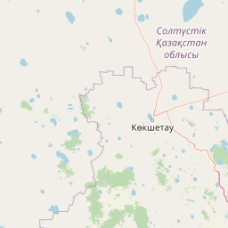
Geographic Profile and Mapped Boundaries of Kokshetau National Park in Aqmola Region
The geography of Kokshetau National Park spans 1821 square kilometers within the Aqmola and North Kazakhstan regions. This profile details the upland terrain, including diverse lake networks, riverine systems, and forest habitats contained within its 689 kilometer perimeter. Analyze the spatial extent and environmental characteristics defining this boreal landscape.

Kazakh upland forest-steppe preserve with lakes, granite peaks, and ancient archaeological sites
Kokshetau National Park
Kokshetau National Park is a protected area in northern Kazakhstan spanning the transition zone between the Siberian taiga forests to the north and the open steppes of the south. Established in 1996, the park covers approximately 182,000 hectares of the Kokshetau Hills, a cluster of low mountains, forested ridges, and lake-filled depressions that rise from the surrounding semi-arid plains. This unique setting creates an island of biodiversity in the heart of the Kazakh uplands, where boreal forest species coexist with steppe flora in a landscape of considerable scenic variety. The park is situated in Zerendi District of Aqmola Region and Aiyrtau District of North Kazakhstan Region, roughly 45 kilometers west of the city of Kokshetau itself. The protected area encompasses five main management sectors: the Zerenda branch around Lake Zerenda, the Shalkar branch with its granite upland terrain, the Aiyrtau branch featuring managed forest established in 1898, the Arykbalyk branch centered on a mountainous lake area, and the isolated Ormandy Bulak conservation zone. The park serves as a critical ecological corridor preserving the Kazakh upland ecoregion, one of the few remaining relatively intact grassland and forest ecosystems in northern Kazakhstan.
- Location
- Kazakhstan
- Park type
- National park
- Established
- 1996
- Area
- 1,821 km²
Location overview
Provincial placement within Aqmola and North Kazakhstan regions
Geographic Location of Kokshetau National Park in Kazakhstan
Kokshetau National Park lies in Kazakhstan, positioned within the Aqmola Region and North Kazakhstan Region. The entirely inland reserve contains no marine or coastal areas and is managed under domestic jurisdiction.
- Countries
- Kazakhstan
- Regions
- Aqmola Region, North Kazakhstan Region
- Primary location
- Aqmola Region
- Geographic setting
- Inland
Boundary and coordinates
Interactive protected-area geometry and calculated spatial metrics
Kokshetau National Park Boundary Map and Spatial Extent
Mapped park geometry establishes spatial context for the protected area across regional terrain. Accompanying boundary facts detail total surface area, coordinate limits, and geographic span without implying legal-survey precision.
- Boundary area
- 7,538.9 km²
- Boundary perimeter
- 689.2 km
- Northernmost point
- 53.8076° N
- Southernmost point
- 52.5431° N
- Easternmost point
- 69.3525° E
- Westernmost point
- 67.6117° E
- Geographic centre
- 53.0583° N, 68.3079° E
- North–south span
- 140.7 km
- East–west span
- 116.4 km
Terrain and natural features
Upland mountain terrain classifications and recorded hydrologic features
Kokshetau National Park Terrain and Named Natural Features
Kokshetau National Park features upland mountain terrain classifications enclosing multiple recorded lakes, rivers, streams, and peaks. Linked feature cards supply names, types, and spatial relationships for each mapped natural entity.
Selected named natural features
Lakes
Айдабыл көлі
Peaks
Жыланды
654 m
Lakes
Құсбек
Lakes
Жетікөл
Rivers
Қуаша
Environmental setting
Boreal uplands with major waters, forest, grassland, and wetland context
Kokshetau National Park's environmental setting and habitats
Kokshetau National Park combines boreal climate, upland relief, major water, forest cover, and year-round seasonality. Mountain, grassland, wetland, lake, river, and forest labels link to atlas themes without suggesting uniform terrain.
- Relief
- Upland
- Climate
- Boreal
- Water
- Major water bodies
- Forest cover
- Mostly forested
- Seasonality
- Year-round
Landscape features
Mountains · Hills · Valleys · Forest · Woodland · Grassland · Wetland · Lakes · Rivers · Waterfalls · Cave
Habitat types
Temperate broadleaf forest · Temperate coniferous forest · Boreal forest · Grassland · Wetland · Riverine habitat · Lacustrine habitat
Park atlas
Trace the forest-steppe transition zone and compare granite mountain landscapes with other protected areas near the Kazakh uplands.
Discover Nearby Protected Areas and National Parks Around Kokshetau National Park
Explore a curated list of national parks and protected areas geographically close to Kokshetau National Park, revealing Kazakhstan's diverse forest-steppe islands, ancient geological formations, and surrounding regional landscapes. This expanded atlas view provides essential geographic context and enables detailed comparison of conservation efforts across similar ecological zones and unique protected landscapes.

National parkAqmola Region
58 km away#1 closest
East

Burabay State National Nature Park: Mapped Granite Hills and Forested Terrain Atlas
Explore protected landscapes in Kazakhstan's Aqmola Region.
Burabay State National Nature Park presents a unique protected landscape within the Kokshetau Massif of Kazakhstan's Aqmola Region. This atlas-focused entry details the park's distinctive terrain, featuring ancient granite outcrops and rolling hills draped in pine and birch forests. Understand the mapped boundaries and geographic setting of this national park, renowned for its scenic lakes and significant geological formations, offering rich context for protected-area discovery.
- Area
- 1,299.35 km²
- Established
- 2000
- IUCN
- II
- Relief
- Mixed relief
Natural monumentNorth Kazakhstan Region
About 87 km away#2 closest
Northwest
Zhanazhol Pine Forest: Protected Natural Monument in North Kazakhstan Region
Mapped relict pine grove within the forest-steppe transition
Zhanazhol Pine Forest serves as a protected natural monument, preserving an isolated stand of mature Scots pine trees on sandy substrates. This site provides critical insights into the biogeography of the Ishim-Tobol interfluve, maintaining a distinct forest environment far from typical boreal ranges.
- Area
- 0.09 km²
- Relief
- Lowland
- Climate
- Temperate
- Access
- Access unknown
Protected areaKostanay Region
About 131 km away#3 closest
West
Koibagar-Tyntyugur Lakes: Protected Wetland Geography in Northern Kazakhstan
Steppe-wetland mosaic and Ramsar-recognized migratory habitat
Located in the Kostanay Region, the Koibagar-Tyntyugur Lakes represent a complex system of shallow, interconnected basins. These protected landscapes illustrate the dramatic hydrological cycles of the Saryarka edge, shifting from open water to reed-filled marshes. The region remains a benchmark for conservation, featuring essential waterbird habitats and rare fragments of pristine feather-grass steppe.
- Area
- 623.45 km²
- Established
- 2005
- Relief
- Lowland
- Scope
- Terrestrial
Wildlife reserveAkmola Region
About 139 km away#4 closest
South
Atbasar Wildlife Reserve: Protected Steppe Grasslands and Wildlife Habitat in the Akmola Region
Mapping conservation landscapes of northern Kazakhstan
Explore the geographic scope of Atbasar Wildlife Reserve, a significant sanctuary in northern Kazakhstan. This protected area preserves key steppe ecosystems and habitat for marmots and migratory birds within a unique terrain of rocky spurs and open feather grass plains.
- Area
- 751 km²
- Established
- 1976
- IUCN
- IV
- Relief
- Upland
National parkAkmola Region
About 312 km away#5 closest
Southeast
Buiratau State National Nature Park: Kazakhstan National Park within Akmola Region
Explore unique steppe-forest transition ecosystems and geography.
Buiratau State National Nature Park in Kazakhstan's Akmola Region protects a significant transitional zone between dry steppe and semi-arid forest. This national park showcases a diverse landscape of low ridges, plains, and salt lakes, contributing to its rich biodiversity. Discover the mapped boundaries and the unique ecological character of this protected area within the context of the Kazakh Uplands atlas and its regional geography.
- Area
- 890 km²
- Established
- 2011
- IUCN
- II
- Relief
- Upland
Nature reserveKostanay Region
About 379 km away#6 closest
Southwest
Altyn Dala Nature Reserve: Mapping Steppe Biodiversity and Migratory Corridors in Kazakhstan
A comprehensive look at the three-cluster protected landscape and regional geography
Spanning over 489,000 hectares, Altyn Dala Nature Reserve preserves diverse habitats ranging from the Sarykopa lake system to the vast Uly-Zhylyanshyk semi-desert steppe. This detail page tracks the reserve's unique cluster structure, geographic boundaries, and essential role in maintaining the historical integrity of northern Kazakhstan's grassland and river corridor ecosystems.
- Area
- 4,897.66 km²
- Established
- 2012
- IUCN
- VI
- Relief
- Lowland
Wildlife reserveKostanay Region
About 398 km away#7 closest
West
Mikhaylovsky Zakaznik: Geographic Overview of the Kostanay Region Wildlife Reserve
A protected forest steppe sanctuary in northern Kazakhstan.
Mikhaylovsky Zakaznik acts as an enduring zoological refuge within the Kostanay Region, protecting a rich tapestry of woodland and meadow steppe environments. This reserve supports native ungulates and game birds by maintaining a stable, low-profile landscape of birch and pine groves that function as critical corridors for biodiversity across the borderlands.
- Area
- 768 km²
- Established
- 1967
- Relief
- Upland
- Access
- Access unknown
Protected areaKostanay Region
About 418 km away#8 closest
West
Taldykol Protected Area: Geographic Atlas and Wetland Landscape Analysis
A vital Ramsar-listed freshwater steppe habitat in Kostanay Region
Taldykol acts as a critical freshwater sanctuary within the dry climate of northern Kazakhstan. This protected area, defined by its central island and willow-fringed margins, forms an essential part of the Kulykol-Taldykol lake system. The basin provides a necessary stopover and breeding site for waterbirds, demonstrating how local water features define the ecological character of the surrounding Kostanay Region steppe terrain.
- Area
- 10.5 km²
- Relief
- Lowland
- Scope
- Terrestrial
- Water
- Water-dominated
MoriAtlas Explorer
Continue Your Atlas Exploration of Kokshetau National Park's Geographic Identity
Deepen your understanding of Kokshetau National Park by exploring its specific mapped boundaries, unique geological features, and the regional geography it inhabits. MoriAtlas provides the structured data to analyze its protected landscape context, allowing for comparative study and a richer appreciation of its place within Kazakhstan's diverse natural heritage. Discover the intricate details that define this significant national park and its surrounding environment.
Browse next
Global natural geography
Explore related park routes
Explore MoriAtlas Global ParksBrowse All MoriAtlas ParksGlobal Park Map DiscoveryMoriAtlas: Browse All CountriesBrowse All MoriAtlas ContinentsNational Park Environment AtlasGrand Canyon National Park AtlasYellowstone National Park AtlasYosemite National Park Atlas and GeographySerengeti National Park AtlasGalápagos National Park Protected LandscapeBanff National Park Geography and AtlasKruger National Park Atlas EntryUluṟu-Kata Tjuṯa National Park AtlasExplore Uluru-Kata Tjuta National Park GeographyPlitvice Lakes National Park AtlasFiordland National Park Protected LandscapeGreat Smoky Mountains National Park AtlasAfghanistan National Parks and Protected AreasAlbania National Parks and Protected AreasAlgeria National Parks and Protected AreasAmerican Samoa National Parks and Protected AreasAndorra National Parks and Protected AreasAngola National Parks and Protected AreasAntarctica National Parks and Protected AreasAntigua and Barbuda Park List