

Mori Atlas logo
Nature reserveKota Kinabalu Wetland Centre

Examining the ecological boundaries and protected wetland landscapes of this urban sanctuary

Kota Kinabalu Wetland Centre: A Coastal Mangrove Nature Reserve in the Heart of Sabah

The Kota Kinabalu Wetland Centre serves as a critical 24-hectare remnant of coastal mangrove forest, representing the only significant natural shoreline habitat remaining within the capital of Sabah. This nature reserve functions as an essential ecological refuge where freshwater inflows meet marine tides, supporting a diverse array of resident species and migratory waterbirds. Through this atlas view, you can trace the boundaries of the forest, understand its role in coastal stabilisation, and explore the mapped terrain that separates this Ramsar-designated site from the surrounding urban footprint of Kota Kinabalu.

mangrove foresturban wetlandcoastal reservebird sanctuaryRamsar sitebirdwatching

Kota Kinabalu Wetland Centre

Nature reserve

Park overview

Structured park overview, official facts, and landscape profile for Kota Kinabalu Wetland Centre

Kota Kinabalu Wetland Centre park facts, protected area profile, and essential visitor context

Review the core facts for Kota Kinabalu Wetland Centre, including designation, size, terrain, visitor scale, habitats, and operating context in one park-focused overview.

About Kota Kinabalu Wetland Centre

Kota Kinabalu Wetland Centre is a small but ecologically significant mangrove reserve that anchors a broader effort to protect coastal wetlands in Sabah. The 24-hectare site represents the surviving remnant of a mangrove system that once fringed much of the greater Kota Kinabalu coastline. As the city expanded through the late twentieth century, most of these mangroves were lost to land reclamation, infrastructure, and development, leaving the Likas area as the principal refuge of this habitat type within the urban boundary.

What gives the centre its broader identity is the way it combines three overlapping roles. Ecologically, it shelters a mangrove community along the tidal interface where freshwater from inland waterways meets the Sulu Sea. For wildlife, it supports both resident tropical species and migratory birds that follow the East Asian and Australasian flyways. As a public resource, it offers boardwalk-based access that lets visitors and school groups step directly into a mangrove forest without leaving the limits of the city.

The reserve is also notable because it operates under multiple layers of recognition. Internationally, it has been listed as a Ramsar site since 2016, a status granted to wetlands of global importance. Regionally, the Sabah Wetlands Conservation Society supports its management, education, and outreach work. Within Sabah itself, the wetland's role as a marine breeding area falls partly under the oversight of the Fishery Department, reflecting how the mangroves sustain not only birds but also fisheries that local communities depend on.

For travellers interested in Borneo's biodiversity, the centre offers one of the most accessible ways to experience a mangrove ecosystem. The boardwalk leads through a forest where tides, roots, and bird calls shape the daily rhythm of the place, and where the proximity to urban life makes the mangrove feel both fragile and essential, a working edge between the city and the sea rather than a distant wilderness.

Quick facts and research context for Kota Kinabalu Wetland Centre

Kota Kinabalu Wetland Centre occupies 24 hectares of mangrove forest in the Likas district of Kota Kinabalu, Sabah, on the northwest coast of Malaysian Borneo. It was identified as a priority wetland in 1986 by the Sabah Wetlands Inventory Committee and has since operated as a bird sanctuary and mangrove reserve. The site also functions as a marine breeding ground protected under Sabah's Fishery Department. In 2016 it was formally designated as a Ramsar wetland, placing it within the international network of globally important wetland sites.

Protection and recognition

Documented terrestrial protection scope, designation year, and recognition sources

Kota Kinabalu Wetland Centre Protection Status and Designation Records

Kota Kinabalu Wetland Centre maintains a documented terrestrial protection status established in the year 2016. Official designation history and management scope details provide structured context for exploring protected area records.

Protection details

Protection scope
Terrestrial
Designated year
2016
Transboundary protection
No
Park context

Deeper park guide and search-rich context for Kota Kinabalu Wetland Centre

Kota Kinabalu Wetland Centre history, landscape, wildlife, and travel context

Explore Kota Kinabalu Wetland Centre through its history, landscape character, ecosystems, wildlife, conservation priorities, cultural context, and seasonal travel timing in a structured park guide built for atlas discovery and search intent.

Why Kota Kinabalu Wetland Centre stands out

The centre is best known for being the last major stand of mangrove forest within Kota Kinabalu's urban footprint, and for the diversity of resident and migratory waterbirds that depend on it. The site draws birdwatchers searching for species from across the Asian flyway, including egrets, herons, bitterns, kingfishers, and seasonal winter visitors from Siberia, China, and northern Asia. Its compact size, accessible location within the city, and Ramsar recognition combine to make it one of Sabah's most prominent urban wetlands.
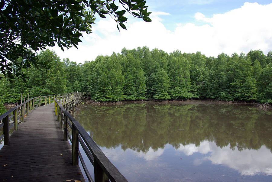
A wooden boardwalk extending over a calm, brown water surface with a dense mangrove forest in the background.
A wooden boardwalk winding through the mangrove forest at Kota Kinabalu Wetland Centre.

Kota Kinabalu Wetland Centre history and protected-area timeline

The history of Kota Kinabalu Wetland Centre is closely tied to efforts in Sabah to catalogue and protect the state's remaining coastal wetlands. In 1986, the Sabah Wetlands Inventory Committee evaluated twenty wetlands across Sabah and identified the Likas mangrove area as the most important to protect within the Kota Kinabalu region. This recognition transformed what had been known locally as Likas Swamp or Likas Mangrove into a formally acknowledged sanctuary, eventually renamed Kota Kinabalu City Bird Sanctuary and, in its current form, Kota Kinabalu Wetland Centre.

The site's transition from a local swamp to an internationally recognised wetland culminated in its inscription as a Ramsar site on 22 October 2016. This designation places the mangrove within the global framework for the conservation of wetlands and underscores its importance for migratory waterbirds and coastal ecosystem services.

Alongside its conservation history, the centre has gradually developed an educational and visitor role, supported by the Sabah Wetlands Conservation Society and other partners. Boardwalks, binocular rentals, and orientation services have been introduced over time, allowing it to function as a destination for casual visitors as well as a working reserve supporting research, monitoring, and public awareness of mangrove ecology in Sabah.

Kota Kinabalu Wetland Centre landscape and geographic character

The landscape of Kota Kinabalu Wetland Centre is defined by a coastal mangrove belt shaped by tides and freshwater inflow. The mangrove forest stands along a low-lying coastal strip where brackish water conditions support trees adapted to saline, waterlogged soils. The result is a forest that feels distinct from both inland rainforest and the open sea: dense, root-bound, quiet, and edged by mudflats.

A raised wooden boardwalk around 1.5 kilometres long cuts through the reserve, allowing visitors to move through the mangrove canopy without disturbing the substrate. The walkway is designed to lead deep into the area where land transitions to tidal reaches, giving a clear sense of how the mangrove occupies the narrow ecological seam between the city of Kota Kinabalu and the wider coastal waters. The atmosphere along the boardwalk includes the characteristic interplay of mangrove shadow, coastal breezes, and the sound of birds overhead, which has become part of the site's appeal.

Surrounding the mangrove are elements of the broader Likas coastal plain. Freshwater channels, reclaimed land, and urban development frame the reserve, making its remaining forest feel even more distinct. In essence, the landscape of the centre is a small but intact coastal wetland fragment, preserved against strong urban pressures and serving as a tangible reminder of what the natural shoreline of Kota Kinabalu once looked like.

Kota Kinabalu Wetland Centre ecosystems, habitats, and plant life

The nature of the reserve is rooted in mangrove ecology, one of the most productive and ecologically distinctive habitats found along tropical coastlines. The mangrove community here supports a vertical structure of salt-tolerant trees and shrubs adapted to tidal fluctuation, with specialised root systems that stabilise soft sediment and create sheltered microhabitats beneath the canopy.

Beyond the trees themselves, the mangrove habitat creates conditions that build the entire ecosystem around it. Fallen leaves and organic matter feed a rich detrital cycle that sustains invertebrates, crustaceans, and small fish. The intertidal mudflats and pools around the roots serve as nursery areas for marine species, while the canopy and sheltered channels provide cover for resident birds.

The reserve illustrates several of the core ecological functions of mangroves that are recognised globally. These forests help to trap sediment, reduce coastal erosion, filter runoff from inland, and protect adjacent freshwater supplies from excessive salt intrusion. The presence of these processes within an urban setting makes the nature of the centre unusually demonstrative: each function can be observed at close range, from the visible role of roots in stabilising the tidal soils to the brackish transition zones that mark where freshwater meets seawater.

Kota Kinabalu Wetland Centre wildlife and species highlights

Wildlife is a defining feature of Kota Kinabalu Wetland Centre, especially its birdlife. The mangrove is both a refuge for resident species and a seasonal destination for migratory birds travelling along the East Asian and Australasian flyways, making it a rich site for birdwatching within Sabah. Seasonal patterns play a major role in observation: the migratory bird season, broadly from September through April, brings many visitors from across Asia and beyond.

Common visitors include little egrets and striated herons that winter in Borneo, white-winged terns that range across the Greater Sunda Islands, marsh sandpipers arriving from Siberia and China, and black-crowned night herons that winter in parts of Sumatra and North Borneo. Cinnamon bitterns breed in tropical Asia while some northern populations move short distances, and common redshanks represent a broader group of widespread shorebirds that visit the mangrove fringes. The lesser adjutant and nankeen night heron are noted as rarer sightings, adding occasional excitement for birdwatchers.

The reserve also supports a set of year-round residents. Crested mynas, yellow-vented bulbuls, yellow-bellied prinias, magpie robins, Pacific swallows, spotted doves, collared kingfishers, purple herons, and green pigeons are among the species that maintain a continuous presence in the mangrove canopy and edges.

Beyond birds, the mangroves host a wide range of other wildlife. Monitor lizards forage across the tidal flats, fiddler crabs colonise the exposed mud, and mudskippers move between pools and air. The reserve also supports weaver ants, butterflies and other insects, jellyfish in tidal channels, water snakes, and mud lobsters in the substrate. Together these groups complete an ecosystem typical of Southeast Asian mangroves, with the birds providing the most visible layer and the invertebrates and reptiles forming the foundation of the food web.

Kota Kinabalu Wetland Centre conservation status and protection priorities

Conservation sits at the heart of the reserve's identity. The mangrove represents a surviving fragment of a coastal forest ecosystem that has been extensively lost to urban development across Kota Kinabalu, so the site's first conservation value is simply its continued existence. Its 24 hectares protect mangrove species, intertidal habitat, and the ecological functions that the broader mangrove corridor once provided along this part of Sabah's coast.

The centre also holds formal recognition at both regional and international levels. It was identified through the Sabah Wetlands Inventory of 1986 as the most important of twenty candidate wetlands in the state, and in 2016 it was designated a Ramsar wetland, officially joining the global network of wetlands recognised for their ecological, hydrological, and biodiversity value. The Ramsar listing is particularly significant for migratory waterbirds, because it connects the reserve to international efforts to protect flyway habitat from Siberia through East and Southeast Asia.

At a local level, the reserve serves as a marine breeding ground for fisheries supported and monitored by the Fishery Department of Sabah, underscoring how mangrove conservation is tied to broader coastal livelihoods. Educational activity, managed by the Sabah Wetlands Conservation Society, extends its conservation role beyond the reserve itself, raising awareness of how mangroves filter water, stabilise sediment, store nutrients, and buffer coastlines against erosion and salinity intrusion. In this way, the centre functions simultaneously as a refuge for wildlife, a safeguard for ecosystem services, and a teaching tool for the public.

Kota Kinabalu Wetland Centre cultural meaning and human context

The cultural context of the centre is closely tied to the identity of Kota Kinabalu itself as a coastal capital built on reclaimed and developed shoreline. Local communities have long understood the mangrove area as Likas Swamp or Likas Mangrove, names that reflect the area's history as a working coastal landscape rather than a remote wilderness. Its renaming and re-designation as a bird sanctuary, and later as the Kota Kinabalu Wetland Centre, marked a shift in how residents and authorities valued the same piece of coast.

For Sabah today, the reserve represents an effort to retain a tangible connection to the natural coastal heritage that development has largely replaced. The proximity of mangrove, sea, and city within walking distance of the central business district gives the site a distinct local character, blending urban life with coastal wildlife in a way uncommon for major Southeast Asian capitals. As such, the centre has become both an ecological refuge and a cultural landmark, embodying a regional interest in balancing growth with the preservation of distinctive coastal habitats.

Top sights and standout views in Kota Kinabalu Wetland Centre

Standout qualities of the Kota Kinabalu Wetland Centre include its status as the principal surviving mangrove habitat within the urban boundary of Kota Kinabalu, its designation as a Ramsar wetland since 2016, and its unusual accessibility within a major regional capital. The 1.5-kilometre wooden boardwalk leads visitors deep into the mangrove where freshwater and sea meet, creating an immersive experience of the coastal interface that is rare in urban Southeast Asia.

The reserve is also distinguished by its layered wildlife profile. Resident species such as collared kingfishers, purple herons, and crested mynas share the mangrove with seasonal visitors from Siberia, China, and wider tropical Asia, including egrets, herons, bitterns, and shorebirds. The combined presence of these species, together with monitor lizards, mudskippers, and fiddler crabs along the tidal flats, makes the centre one of the most rewarding birdwatching and nature spots in Sabah for visitors without time to venture into deeper rainforest or remote marine habitats.

Best time to visit Kota Kinabalu Wetland Centre

The centre has a tropical climate with relatively stable conditions through the year, but the character of a visit varies meaningfully with bird season. The migratory bird season, broadly from September through April, tends to be the most rewarding period for visitors interested in waterbirds and herons, because winter visitors from northern Asia join the resident birdlife in the mangrove at this time. Visits during these months offer the greatest diversity of species and align with the cooler, often drier period on Sabah's west coast.

Outside of bird season, the mangrove still provides a tranquil green experience within the city. Daylight periods offer the best visibility along the boardwalk and for photography, and early morning or late afternoon light tends to bring the highest bird activity. Because the site sits within an urban setting, it remains a calm but accessible destination whenever travel plans allow, with seasonality shaping what visitors see rather than whether they can visit at all.
Monthly climate preview

Long-term monthly temperature averages and precipitation records for Sabah

Kota Kinabalu Wetland Centre Climate Normals and Annual Weather Patterns

Historical climate data from 1991 to 2020 outlines measured temperature ranges and precipitation rates across twelve representative months at Kota Kinabalu Wetland Centre. Examining the complete monthly climate normals reveals detailed long-term environmental patterns for this protected Sabah location.
Annual mean25 °C
24 °C25 °C
Jan24°
Feb24°
Mar25°
Apr25°
May25°
Jun25°
Jul25°
Aug25°
Sep25°
Oct24°
Nov25°
Dec24°
Warmest month
May

25.4 °C

Coolest month
February

23.9 °C

Wettest month
October

11.9 mm/day

Driest month
March

3.4 mm/day

Park location guide

Geography guide, regional context, and park location map for Kota Kinabalu Wetland Centre

Kota Kinabalu Wetland Centre park geography, regions, and map view in Malaysia

Understand where Kota Kinabalu Wetland Centre sits in Malaysia through a broader geographic reading of the surrounding landscape, nearby location context, and its mapped position within the national park landscape.

How Kota Kinabalu Wetland Centre fits into Malaysia

Malaysia is a federal constitutional monarchy located in Southeast Asia. The country consists of 13 states and three federal territories, divided by the South China Sea into Peninsular Malaysia on the Indochinese Peninsula and East Malaysia on the island of Borneo. With a population of over 34 million, it achieved independence from Britain in 1957 and became a modern federation in 1963. The country is recognized for its multicultural population, tropical climate, and significant economic role in the region.

Wider geography shaping Kota Kinabalu Wetland Centre in Malaysia

Malaysia occupies a strategic position in Southeast Asia, split by the South China Sea into two distinct regions. Peninsular Malaysia lies on the Indochinese Peninsula, sharing a land border with Thailand to the north and maritime borders with Singapore, Vietnam, and Indonesia. East Malaysia occupies the northern portion of Borneo, sharing land borders with Brunei and Indonesia, and maritime borders with the Philippines and Vietnam. The country's terrain includes coastal plains, mountain ranges such as the Titiwangsa in the peninsula, and extensive tropical rainforests.

Map view of Kota Kinabalu Wetland Centre

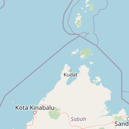
Use this park location map to pinpoint Kota Kinabalu Wetland Centre in Malaysia, understand its exact geographic position, and read its mapped placement within the surrounding landscape more clearly.

Pigeon | © OpenStreetMap contributors

Location context for Kota Kinabalu Wetland Centre

Sabah

Explore photographic records of tidal mudflats, boardwalks, and coastal habitats across Sabah.

Kota Kinabalu Wetland Centre Photos and Landscapes: Visualizing the Urban Mangrove Reserve

Visual documentation reveals the dense root structures, brackish water channels, and protected canopy formations defining this coastal sanctuary. Photographic records provide clear context on the native flora, avian wildlife habitats, and urban wetland geography preserved within the capital.

A wooden boardwalk extending over a calm, brown water surface with a dense mangrove forest in the background.

Park atlas

Compare coastal mangroves, regional wetlands, and connected protected landscapes

Explore Other Parks Near Kota Kinabalu Wetland Centre and Surrounding Regional Protected Areas

Continue browsing national parks and protected areas located near Kota Kinabalu Wetland Centre to compare coastal mangrove ecosystems with wider regional habitats. Broadening the geographic scope helps researchers and conservation enthusiasts examine related reserves across the surrounding landscape.
National parkSabah
About 9.8 km away#1 closest

West

Tunku Abdul Rahman National Park: Sabah National Park Protected Landscape & Geography

Explore mapped boundaries and regional context.

Tunku Abdul Rahman National Park, designated as a national park, offers a specific focus on protected landscape exploration within Sabah. This entity details its geographic footprint and its significance as a mapped natural area. Understanding its role within the regional geography allows for a more complete exploration of Malaysia's protected lands through an atlas perspective.

Area
49 km²
Established
1974
IUCN
II
Relief
Mixed relief
National parkMalaysia
About 50 km away#2 closest

South

Crocker Range National Park: A Protected Landscape within Malaysia's Borneo Region

Mapped boundaries and regional geography context for exploration.

Crocker Range National Park represents a significant protected area within Malaysia, contributing distinct geographic features and landscape context to the Borneo region. This detailed view supports atlas exploration by outlining the park's mapped boundaries and its role within the nation's protected lands. Understand the park's specific location and geographic identity, enriching your comprehension of Malaysian natural landscapes and conservation areas.

Area
1,399 km²
Established
1984
IUCN
II
Relief
Mountain
National parkMalaysia
About 57 km away#3 closest

Southwest

Pulau Tiga National Park: A Protected Landscape within Malaysia's Geographic Context

Discover its mapped boundaries and regional natural terrain.

Pulau Tiga National Park stands as a distinct protected area, offering valuable insights into Malaysia's varied geography. This detail page is designed for structured discovery, highlighting the park's specific mapped boundaries and its contribution to the regional landscape context. Users exploring this national park will find a focused entry into understanding its protected status and its place within the atlas of Southeast Asian natural wonders.

National parkSabah
About 57 km away#4 closest

Southwest

Tiga Island National Park: Geological Mapping and Protected Coastal Landscapes in Sabah

A marine protected area shaped by mud volcano activity

This park encompasses three distinct islands created by mud volcanic eruptions in the South China Sea. Featuring a unique combination of soft, water-saturated terrain, white sandbars, and rocky outcrops, the area offers a compelling look at dynamic coastal geography. The marine environment supports extensive coral reefs and shoals, making the protected zone a key example of geological and marine diversity within the Sabah region.

Area
158 km²
Established
1978
IUCN
II
Relief
Lowland
National parkMalaysia
About 65 km away#5 closest

East

Kinabalu National Park: Mapped Boundaries and Protected Landscape Atlas

Exploring Malaysia's Natural Terrain and Park Geography

Delve into the specific protected area identity of Kinabalu National Park, situated within Malaysia. This resource details its geographic scope and mapped terrain, providing a foundation for understanding its role as a national park. Examine the park's protected landscape context, offering valuable insights for anyone exploring regional geography and conservation areas through an atlas lens.

Area
754 km²
Established
1964
IUCN
II
Visitors
611.6K annual
A pale, minimalist watercolor painting depicting a gentle, rolling landscape with green and light red washes, suggesting hills and distant foliage against a soft, bright background.
National parkSabah
About 65 km away#6 closest

East

Kinabalu Park: Geographic Overview and Protected Landscape Mapping in Sabah, Malaysia

A study of vertical mountain terrain and biodiversity boundaries

Kinabalu Park stands as a defining natural entity in Sabah, Malaysia, characterized by its extreme elevation changes and concentration of rare botanical life. This atlas resource maps the park's physical geography, from its cloud-shrouded forests to its rocky summit plateaus, offering a detailed look at one of Southeast Asia's most significant protected mountain environments.

Area
754 km²
Established
1964
IUCN
II
Visitors
611.6K annual
Nature reserveSabah
About 156 km away#7 closest

Southeast

Maliau Basin Nature Reserve: Geographic Overview and Protected Landscape Mapping

Sandstone escarpments and river drainage in Sabah, Malaysia

Explore the structural geography of Maliau Basin, a prominent nature reserve in Sabah. This protected area is defined by its massive sandstone depression, multi-tiered waterfalls, and expansive primary forest coverage. Examine the watershed dynamics of the Maliau River and the mountainous terrain that isolates this significant wilderness from surrounding lowland regions.

Area
588 km²
Established
1981
IUCN
Ia
Water
Major water bodies
Nature reserveTemburong District
About 170 km away#8 closest

Southwest

Peradayan Forest Reserve Nature Reserve: Understanding its Protected Landscape and Geographic Setting

Explore mapped boundaries and the natural terrain of this Brunei reserve.

Peradayan Forest Reserve stands as a significant protected natural area within Brunei's Temburong District, an exclave characterized by vast tropical rainforests. This entry focuses on its identity as a nature reserve, providing key geographic context and details about its mapped boundaries. Understand its role within the regional landscape and how its protected status contributes to the conservation of Brunei's natural heritage, facilitating a deeper dive into atlas-style geographic exploration.

Area
26.5 km²
Relief
Upland
Climate
Tropical
Access
Moderate access

Common questions about visiting, size, designation, and location context for Kota Kinabalu Wetland Centre

Kota Kinabalu Wetland Centre FAQs for park facts, access, geography, and protected area context

Find quick answers about Kota Kinabalu Wetland Centre, including protected-area facts, park geography, trail and visitor context, and how the park fits into its surrounding country and regional landscape.
MoriAtlas Explorer

Continue Your Protected Areas Search Across the Global Atlas

Deepen your exploration by continuing the structured search for national parks and protected areas worldwide. Utilize the comprehensive filtering capabilities to compare different conservation landscapes and refine your understanding of global park geography. Discover more about the distribution and characteristics of protected natural areas.

Global natural geography
