
Mori Atlas logo
Nature reserveKottenforst-Waldville

Exploring the ecological boundaries, woodland terrain, and regional geography of this Natura 2000 protected forest complex.

Kottenforst-Waldville Nature Reserve: A Protected Forest Mosaic in the German Rhine Terrace Landscape

(EU-Vogelschutzgebiet „Kottenforst-Waldville")

Kottenforst-Waldville functions as a coherent, large-scale forest complex situated upon the expansive Rhine terrace south of Bonn. This protected area represents an essential ecological mosaic of oak-hornbeam forests, narrow stream-carved valleys, and seasonal woodland pools, providing vital habitat for specialized bird species such as the Middle Spotted Woodpecker and the Black Stork. Its geographic distribution spans five distinct sub-areas, showcasing the interplay between old-growth woodland stands, spring-fed mires, and the surrounding low-relief terrain of the Cologne Rhine lowlands.

Special Protection AreaNatura 2000EU Birds Directivedeciduous forestoak-hornbeam woodlandbeech forest
A flat-style digital illustration of a mountain valley featuring tall, rocky cliffs, a tiered waterfall, a river flowing through the center, and a foreground of pine trees.

Kottenforst-Waldville

Nature reserve

Park overview

Structured park overview, official facts, and landscape profile for Kottenforst-Waldville

Kottenforst-Waldville park facts, protected area profile, and essential visitor context

Review the core facts for Kottenforst-Waldville, including designation, size, terrain, visitor scale, habitats, and operating context in one park-focused overview.

About Kottenforst-Waldville

Kottenforst-Waldville is one of the larger forest-based bird protection areas in North Rhine-Westphalia. It lies in the southern part of the state, in and around the city of Bonn and the surrounding Rhein-Sieg-Kreis, and is administered by the Regierungspräsidium Köln as part of the Regierungsbezirk Köln. With five separated sub-areas adding up to roughly 36 square kilometers, the protection area represents a significant share of the remaining large, contiguous woodland of the Cologne Rhine lowlands.

The site occupies the nearly level main terrace of the Rhine, the broad Pleistocene surface that runs south of the river before the land rises toward the Eifel foothills. Despite the modest relief of the terrace itself, the forest interior is broken by steep narrow valleys, locally called "Siepen", carved by spring-fed brooks draining toward the Rhine. These valleys, together with small summer-dry woodland pools, near-natural alder-floodplain strips along the streams, and isolated spring mires, give the woodland an internal complexity that is unusual for such a flat regional setting.

The forest composition is dominated by deciduous trees, with oak-hornbeam woodland covering large continuous areas and accompanied by beech forest types of both the Hainsimsen and Waldmeister variants. Mature and near-natural old-growth stands are emphasized because of their importance for hole-nesting birds and for the structural complexity on which the site's overall biodiversity depends. The designation explicitly aims to preserve and develop old trees and deadwood within the woodland, and to keep the forest management close to natural processes.

Its position within the Naturpark Rheinland links Kottenforst-Waldville to a broader landscape of low mountain forests and Rhine-side cultural landscapes, while individual smaller nature reserves within it, such as the Katzenlochbachtal, layer additional protection on the most sensitive valley features.

Quick facts and research context for Kottenforst-Waldville

Kottenforst-Waldville is officially classified as an EU Special Protection Area (SPA, Vogelschutzgebiet) under the EU Birds Directive, with the German designation number DE-5308-401 and the WDPA identifier 555537641. The site was established in 2004 by regulation of the Regierungspräsidium Köln and lies within the Regierungsbezirk Köln administrative region.

Its five sub-areas collectively cover approximately 36 square kilometers and stretch across the near-flat main terrace of the Rhine, between Heimerzheim in the northwest, Bad Godesberg in the northeast, and the municipality of Wachtberg in the southeast. The bird protection area sits within the larger Naturpark Rheinland and is partially overlapping with the Naturschutzgebiet "Katzenlochbachtal".

Deciduous woodland dominates the land cover, with broadleaved forest making up about 63 percent of the area, coniferous plantation forest contributing about 25 percent, mixed woodland about 6 percent, and various small shares of inland water, dry grassland and mesic grassland rounding out the habitat composition. The site is attached to the larger forest landscapes continuing south along the Eifel foothills.

Protection and recognition

Documented conservation records and official protected-area designations

Kottenforst-Waldville Protection Status and International Recognition Data

Kottenforst-Waldville protection status details bring together documented designation history and administrative records for the protected area. Official database entries establish baseline conservation frameworks and international recognition tracking without assuming management outcomes.

Protection details

WDPA ID
555537641
Park context

Deeper park guide and search-rich context for Kottenforst-Waldville

Kottenforst-Waldville history, landscape, wildlife, and travel context

Explore Kottenforst-Waldville through its history, landscape character, ecosystems, wildlife, conservation priorities, cultural context, and seasonal travel timing in a structured park guide built for atlas discovery and search intent.

Why Kottenforst-Waldville stands out

Kottenforst-Waldville is particularly known for its exceptionally large and nationally significant population of the Middle Spotted Woodpecker, a species strongly tied to mature oak-rich deciduous forest. It also stands out as one of the largest coherent forest complexes remaining in this part of the Cologne Rhine natural region. The protection area is further distinguished by its unusual concentration of small summer-dry woodland pools, called "Maare" in the local vernacular, together with near-natural spring brooks, steep narrow valleys and alder floodplain woodland. These elements create a varied forest mosaic within an otherwise low-relief Rhine terrace landscape. Woodpeckers are central to the area's identity: in addition to the Middle Spotted Woodpecker, the Grey-headed Woodpecker, Black Woodpecker, and Black Stork all have specific conservation objectives defined for the site, alongside raptors such as the Red Kite and Honey Buzzard.
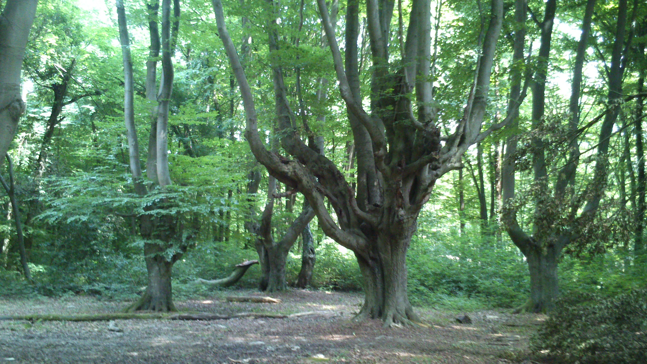
Several pollarded beech trees with thick, gnarly trunks and multiple upright branches standing in a lush, green deciduous forest.
Pollarded beech trees in the Kottenforst forest.

Kottenforst-Waldville history and protected-area timeline

The formal ecological protection era of the current area began in 2004, when the Regierungspräsidium Köln issued a regulation designating Kottenforst-Waldville as an EU Special Protection Area under the European Birds Directive. The site received the official German designation DE-5308-401 and was integrated into the Natura 2000 network as a Vogelschutzgebiet, giving it both national and European legal standing.

Although the protection area itself is relatively recent, the surrounding Kottenforst and Waldville forests have a much longer history as a managed forest landscape south of Bonn. The woodlands have long been valued for their size and continuity, and the Eichen-Hainbuchenwald compositions and old oak stands reflect a long continuity of broadleaved forest cover in the area.

The Natura 2000 designation represents the present-day culmination of a protection story that has gradually layered stricter conservation objectives onto a forest area that is both a regional ecological anchor and an important recreational landscape for the Bonn-Rhine-Sieg area. Linked protected areas, including the Naturpark Rheinland and the smaller Naturschutzgebiet "Katzenlochbachtal", build on this foundation.

Kottenforst-Waldville landscape and geographic character

Kottenforst-Waldville lies on the broad, near-flat main terrace of the Rhine, a low-relief Pleistocene surface that fans out south of the river between Bonn and the Eifel foothills. From a distance the terrain reads as a continuous, gently undulating forested plateau, crossed by a small number of larger routes such as the Bundesautobahn 565 that separate the five sub-areas from one another.

The visual richness of the area comes from micro-relief features rather than dramatic topography. Steep, narrow valleys known as "Siepen" incise the plateau where spring-fed brooks descend toward the Rhine, often opening onto tiny floodplain strips. Locally, the forest floor is dotted with small, seasonally dry woodland pools called "Maare" in regional dialect, giving the otherwise closed oak-hornbeam forest an unusually varied wet-dry micro-pattern.

Streamsides carry alder floodplain woodland and spring-fed mires set within the surrounding oak and beech forests, and there are occasional steep slopes where erosion and slope drainage create locally exposed soils. Although much of the plateau is exposed to wind and edge effects from nearby roads and settlements, the core forest blocks read as uninterrupted woodland when viewed from within.

Kottenforst-Waldville ecosystems, habitats, and plant life

Ecologically, Kottenforst-Waldville is a broadleaved forest site under a mild, Atlantic-influenced middle-European climate. The dominant image is oak-hornbeam woodland of the sub-Atlantic to central European type, interspersed with beech forests of the Hainsimsen and Waldmeister variants, and with alder floodplain strips following the small streams.

Deciduous broadleaved forest as a habitat class dominates the area, covering about 63 percent of the site, while mixed woodland contributes about 6 percent and plantation conifer stands about 25 percent. Inland water surfaces, mesic and wet grassland, and dry grassland each occupy only a few percent of the area, but they form important structural elements within the wider forest matrix.

Habitats protected under the Habitats Directive within the SPA include natural eutrophic lakes with pondweed-type vegetation, lowland hay meadows, Hainsimsen beech forest, Waldmeister beech forest, sub-Atlantic or central European oak-hornbeam forest, and alluvial forests of black alder and common ash. The character of the woodland is one internally heterogeneous deciduous forest with scattered open, wet and dry habitats, rather than a uniform closed-canopy forest.

Kottenforst-Waldville wildlife and species highlights

Faunal interest in Kottenforst-Waldville is dominated by breeding woodland bird species, which are precisely why the area was designated as a Special Protection Area. Woodpeckers are especially significant: the site holds an internationally and nationally important population of the Middle Spotted Woodpecker, along with notable populations of the Grey-headed Woodpecker and the Black Woodpecker, all dependent on mature broadleaved trees with old-growth and deadwood components.

The canopy and understorey birds of the area also include the Nightingale, associated with undergrowth-rich deciduous woodland near water, and the Golden Oriole, linked to light, moist deciduous forest with high old-tree cover. Among raptors, both the Red Kite and the Honey Buzzard are listed as protected breeding species, with the Red Kite tied to open, structurally rich cultural landscapes adjoining forest and the Honey Buzzard to mixed deciduous forest rich in wasps.

The Black Stork benefits from large, quiet, structurally rich deciduous forest tracts with old trees, near-natural streams, moist meadows and woodland pools for feeding. Winter visitors and other priority species include the Common Kingfisher, which depends on dynamic, near-natural flowing water with steep banks and natural nesting sites. Otter signs, fish and amphibian populations, although not stressed in the source, are implicitly supported by the protected small water bodies and near-natural streams.

Kottenforst-Waldville conservation status and protection priorities

Kottenforst-Waldville's conservation value rests on its combination of size, forest continuity and habitat heterogeneity within a heavily populated part of western Germany. The protection area sits in a region where forest fragmentation and land-use pressure are intense, and its five connected sub-areas remain large enough to support species that require extensive, quiet woodland interiors.

The core conservation objective of the site is the maintenance and development of oak-hornbeam, beech and alder-ash forests through near-natural forest management, with a particular emphasis on retaining and increasing the share of old trees and deadwood. Maintaining natural streams, spring mires, ponds and the small "Maare" woodland pools is treated as equally important, because these elements structure the broader bird and habitat diversity.

For each of the priority breeding bird species, the conservation framework lays out specific objectives: for woodpeckers, a permanent supply of suitable cavity trees, especially very old beech and oak, and an absence of fragmentation of the woodland; for the Black Stork, large quiet forest tracts with protected nest trees and at least 200-meter-wide nest protection zones; and for the Red Kite, safe nesting habitat and reduced disturbance in spring and summer. Power lines, secondary poisoning, recreational pressure and habitat fragmentation are all explicitly recognized as risks to be mitigated.

Kottenforst-Waldville cultural meaning and human context

The Kottenforst and Waldville forests have long been part of everyday life for communities south of Bonn, including Heimerzheim, Bad Godesberg, and the municipality of Wachtberg. Local vernacular terms such as "Maare" for woodland pools and "Siepen" for narrow valleys reflect a regional forestry and land-management vocabulary that has evolved alongside these forests.

Within the wider context, the protection area is embedded in the Naturpark Rheinland, a regional landscape framework that combines ecological protection with low-intensity recreation, education and regional identity. This frames the forests not only as a protected nature site but also as a cultural landscape tying Bonn and the Rhine-Sieg area to the natural setting of the Eifel foothills.

Top sights and standout views in Kottenforst-Waldville

Kottenforst-Waldville stands out for the scale of its oak-hornbeam forest in an otherwise heavily populated part of western Germany, and for its nationally important Middle Spotted Woodpecker population. Its five connected sub-areas ensure that, even within an intensively used Rhine terrace landscape, continuous broadleaved woodland of meaningful size survives.

Small-scale landscape elements, including the regional "Maare" woodland pools, steep "Siepen" valleys, alder floodplain strips and spring mires, add ecological complexity within the closed forest canopy. The combination of woodland raptor and woodpecker species, including the Black Stork, Red Kite, Grey-headed Woodpecker and Black Woodpecker, makes the site a key forest bird protection area of the Regierungsbezirk Köln.

As part of the Natura 2000 network and the larger Naturpark Rheinland, Kottenforst-Waldville demonstrates how a regional forest can hold meaningful European-level conservation value close to a major German metropolitan area.

Best time to visit Kottenforst-Waldville

As a forest-based bird protection area, Kottenforst-Waldville offers most of its ecological interest throughout the leaf-on season, when the breeding bird community is active and the woodland shows its full structural complexity. From spring through early summer, the priority breeding species of the SPA, including Middle Spotted and Grey-headed Woodpecker, Black Stork, Nightingale and Red Kite, are most observable, though the protection framework deliberately restricts disturbance in core breeding periods.

In late spring and early summer, the forest understorey is at its most expressive, with the small "Maare" pools, spring mires and alder floodplain strips contrasting strongly with the surrounding oak-hornbeam canopy. In autumn and winter, the deciduous structure becomes more readable, the alder floodplain strips and stream valleys become more visible, and several winter visitors such as the Common Kingfisher are more prominently associated with the streams. The site is best approached as a quiet, low-disturbance woodland experience rather than a heavily seasonal destination.


Monthly climate preview

Long-term representative measurements of monthly averages across the protected terrain

Kottenforst-Waldville Climate Normals, Annual Temperature and Precipitation

Representative coordinate records show measured monthly temperature and precipitation normals for Kottenforst-Waldville from 1991 to 2020. Examining the complete twelve-month sequence reveals the full range of long-term climate patterns recorded at this elevation.
Annual mean9 °C
0 °C18 °C
Jan
Feb
Mar
Apr
May12°
Jun15°
Jul18°
Aug18°
Sep14°
Oct
Nov
Dec
Warmest month
July

17.9 °C

Coolest month
January

0 °C

Wettest month
June

2.5 mm/day

Driest month
April

1.6 mm/day

Park location guide

Geography guide, regional context, and park location map for Kottenforst-Waldville

Kottenforst-Waldville park geography, regions, and map view in Germany

Understand where Kottenforst-Waldville sits in Germany through a broader geographic reading of the surrounding landscape, nearby location context, and its mapped position within the national park landscape.

How Kottenforst-Waldville fits into Germany

Germany is a federal republic in Western and Central Europe with a population of over 83 million across sixteen constituent states. It is Europe's largest economy by nominal GDP and a major global exporter and importer. The capital is Berlin, and the country borders Denmark, Poland, Czech Republic, Austria, Switzerland, France, Luxembourg, Belgium, and the Netherlands.

Wider geography shaping Kottenforst-Waldville in Germany

Germany is located in Western and Central Europe, spanning 357,022 km². It borders Denmark to the north, Poland and the Czech Republic to the east, Austria and Switzerland to the south, and France, Luxembourg, Belgium, and the Netherlands to the west. The country has coastlines on the Baltic Sea and North Sea to the north, with the Alps located in the southern region.

Map view of Kottenforst-Waldville

Use this park location map to pinpoint Kottenforst-Waldville in Germany, understand its exact geographic position, and read its mapped placement within the surrounding landscape more clearly.

Pigeon | © OpenStreetMap contributors

Location context for Kottenforst-Waldville

Nordrhein-Westfalen

Visual reference for oak-hornbeam forests, woodland pools, and protected habitats

Kottenforst-Waldville Photos and Protected Landscape Scenery

Examine detailed visual records of Kottenforst-Waldville to understand the terrain, oak-rich forest canopies, and micro-relief features that define the protected area. These photographic collections offer clear insight into the natural habitats and environmental character spanning the Rhine terrace landscape.

Several pollarded beech trees with thick, gnarly trunks and multiple upright branches standing in a lush, green deciduous forest.

Park atlas

Compare regional forest reserves and protected landscapes across the Cologne lowlands

Exploring Parks Near Kottenforst-Waldville and Surrounding Protected Areas

Browse adjacent protected areas and forested terrain sharing similar ecological traits with Kottenforst-Waldville. Comparing regional park geography provides deeper context into woodland preservation across the Rhine terrace.
A horizontal watercolor painting depicting a gentle, hazy green landscape with rolling hills, a line of trees, and a foreground meadow.
Protected landscapeNorth Rhine-Westphalia
Mapped location lies within the park boundary#1 closest

Northwest

Naturpark Rheinland: Geography and Protected Area Overview in North Rhine-Westphalia

A complex metropolitan nature park and lake district

Naturpark Rheinland represents a distinct convergence of reclaimed lignite mining landscapes, quiet lowland forests, and floodplain wetlands. Its mapped boundaries reveal a diverse terrain of ridges and river valleys that define the environmental character of the Cologne-Bonn metropolitan region.

Area
1,045 km²
Established
1959
Relief
Upland
Climate
Temperate
Nature reserveNorth Rhine-Westphalia
About 4.8 km away#2 closest

Northeast

Melbtal Nature Reserve in North Rhine-Westphalia: Map, Terrain, and Geographic Context

Deep-cut forested valley with unique geological instability

Melbtal stands as a protected nature reserve in Bonn, Germany, defined by its steep wooded slopes and the meandering Melbbach. This geographic entity offers a study in earth-science dynamics, featuring active landslides and a distinct cold-air flow that persists within a dense urban setting. Use this atlas perspective to understand the boundaries, terrain, and layered cultural history of one of the region's most prominent green corridors.

Area
0.2 km²
Established
2013
IUCN
IV
Relief
Upland
A soft watercolor illustration showing a peaceful landscape with gentle hills, trees, and small ponds reflecting light.
Nature reserveNordrhein-Westfalen
About 9.9 km away#3 closest

Northwest

Quarzsandgrube Nature Reserve: Geographic Profile and Protected Landscape Context

Protected mosaic of pioneer habitats in the Rhein-Sieg-Kreis

Located on the terrace slopes of the Rhein-Sieg-Kreis, Quarzsandgrube represents a significant refuge for early successional flora and fauna. The site features an uneven terrain of exposed sandy soils and water-filled hollows, providing a vital habitat corridor alongside adjacent protected areas. This detailed geographic profile maps the environmental conditions that define its current status as a protected nature reserve.

Area
0.29 km²
Established
1994
IUCN
IV
A horizontal watercolor painting of a river landscape with lush green trees, fields, and a distant church spire on the horizon.
Nature reserveRhein-Sieg-Kreis
About 10 km away#4 closest

North

Siegaue und Siegmündung Nature Reserve in Rhein-Sieg-Kreis: A Geographic Overview

Protected floodplain ecosystems and river-mouth geography

The Siegaue und Siegmündung nature reserve protects a critical river-mouth landscape where the Sieg flows into the Rhine. This area features a complex mosaic of wet meadows, softwood alluvial forests, and abandoned river channels, providing essential habitat for migratory waders. The reserve represents a near-natural floodplain environment within the densely populated Cologne-Bonn Rhine plain.

Established
1985
Relief
Lowland
Climate
Temperate
Scope
Terrestrial
A soft watercolor painting showing a winding river with a lush green island in the middle, surrounded by soft-toned riverbanks and trees.
Nature reserveNorth Rhine-Westphalia
About 12 km away#5 closest

North

Herseler Werth Nature Reserve: Geographic Overview of the Rhine River Island Landscape

A strictly protected riverine refuge in North Rhine-Westphalia

Herseler Werth represents a unique study in protected geography as the only non-publicly accessible Rhine island within North Rhine-Westphalia. Spanning 14.8 hectares, this long, narrow river island serves as a critical, human-excluded sanctuary that protects endangered species from industrial and urban disturbance. Its mapped boundaries and poplar-covered terrain illustrate the complex interaction between historical river hydrology and modern conservation efforts along the busy Bonn-Cologne corridor.

Area
0.148 km²
Established
1993
Relief
Lowland
Climate
Temperate
A minimalist watercolor illustration depicting a river winding through soft, rolling hills in pastel tones of green, yellow, and purple.
Nature reserveRhineland-Palatinate
About 17 km away#6 closest

Southeast

Erpeler Ley Nature Reserve: A Volcanic Basalt Landmark in Rhineland-Palatinate

Mapping the geology and protected flora of the Middle Rhine valley.

The Erpeler Ley serves as a monumental volcanic remnant, rising vertically from the Rhine to showcase rare fan-shaped columnar basalt formations. As a protected nature reserve, the site offers vital insight into the heat-loving plant and animal communities that thrive on these ancient lava flows, providing an essential geographic link between the Siebengebirge and the Eifel landscape.

Established
1941
Relief
Mountain
Climate
Temperate
Access
Easy access
Watercolor painting of a soft green landscape with a stream flowing through wetlands and light hills in the distance.
Nature reserveNordrhein-Westfalen
About 17 km away#7 closest

Southwest

Houverather Bach und Nebenbäche: Geography and Protected Brook Systems of the Ahr Eifel

A multi-parcel nature reserve spanning wet meadows and stream-side forest corridors

Houverather Bach und Nebenbäche constitutes a unique protected landscape structured around the Houverather Bach. This reserve comprises eight individual parcels that preserve essential riparian habitats, including reed-fringed fish ponds, meadowsweet-rich grasslands, and beech woodland stands. Spanning the boundary regions of the northern Ahr Eifel, this protected area highlights the importance of maintaining small-scale stream valley ecosystems within the district of Euskirchen.

Area
0.692 km²
Established
2007
Relief
Upland
Climate
Temperate
Watercolor landscape illustration showing a pale river curving through green trees with soft hills in the distance.
Nature reserveNorth Rhine-Westphalia
About 19 km away#8 closest

North

Langeler Auwald: A Protected Floodplain Forest in the North Rhine-Westphalia Rhine Corridor

Examining fluvial landscape patterns and riparian forest boundaries

Langeler Auwald functions as a significant nature reserve on the right bank of the Rhine in Cologne, preserving a rare mosaic of willow-poplar floodplain forest. The terrain encompasses periodically flooded gravel shores, nutrient-poor grasslands on flood dikes, and transitional orchard habitats that support a high density of protected species within the urbanized landscape of North Rhine-Westphalia.

Area
0.224 km²
Relief
Lowland
Climate
Temperate
Scope
Terrestrial

Common questions about visiting, size, designation, and location context for Kottenforst-Waldville

Kottenforst-Waldville FAQs for park facts, access, geography, and protected area context

Find quick answers about Kottenforst-Waldville, including protected-area facts, park geography, trail and visitor context, and how the park fits into its surrounding country and regional landscape.
MoriAtlas Explorer

Continue Your Protected Areas Search Across the Global Atlas

Deepen your exploration by continuing the structured search for national parks and protected areas worldwide. Utilize the comprehensive filtering capabilities to compare different conservation landscapes and refine your understanding of global park geography. Discover more about the distribution and characteristics of protected natural areas.

Global natural geography