

Mori Atlas logo
Wildlife reserveKwangtung Island Wildlife Sanctuary

A focused analysis of habitat boundaries and coastal forest terrain in the North Andaman archipelago.

Kwangtung Island Wildlife Sanctuary: Mapped Geography and Protected Island Landscapes

(Kwangtang Island Wildlife Sanctuary)

Kwangtung Island Wildlife Sanctuary represents a vital protected area on North Andaman Island, safeguarding a compact mosaic of tropical forests and shoreline habitats. This wildlife reserve functions as a key component of the Andaman and Nicobar Islands conservation network, preserving essential nesting and foraging terrain for regional island species. The sanctuary geography demonstrates the unique coastal and forested architecture found across this Bay of Bengal archipelago.

island sanctuarytropical forestcoastal habitatAndaman Islandsbirdwatchingmarine turtles

Kwangtung Island Wildlife Sanctuary

Wildlife reserve

Park overview

Structured park overview, official facts, and landscape profile for Kwangtung Island Wildlife Sanctuary

Kwangtung Island Wildlife Sanctuary park facts, protected area profile, and essential visitor context

Review the core facts for Kwangtung Island Wildlife Sanctuary, including designation, size, terrain, visitor scale, habitats, and operating context in one park-focused overview.

About Kwangtung Island Wildlife Sanctuary

Kwangtung Island Wildlife Sanctuary is one of the many modestly sized island reserves that collectively define the protected-area character of the Andaman and Nicobar Islands. Set on North Andaman Island, it occupies a coastal and forested landscape shaped by the tropical maritime climate of the Bay of Bengal.

The island's relatively small sanctuary area reflects a deliberate conservation approach focused on preserving representative habitat and the species that depend on it, rather than on showcasing large-scale scenery. Tropical trees, shoreline vegetation, and the surrounding sea together create a compact ecosystem where island-restricted birds, reptiles, and marine species coexist in close proximity.

Although the sanctuary is limited in geographic extent, it plays a meaningful part in the wider conservation framework of the Union Territory. Together with neighboring reserves, it contributes to safeguarding biological elements that occur nowhere else in India, making even small island areas like this one valuable for long-term biodiversity protection.

Quick facts and research context for Kwangtung Island Wildlife Sanctuary

Kwangtung Island Wildlife Sanctuary is a protected island reserve located on North Andaman Island in the Andaman and Nicobar Islands of India. It was established in 1987 under the Wildlife Protection Act of 1972 and is classified as an IUCN Category IV protected area.

The sanctuary covers approximately 0.57 square kilometers and lies southeast of McPherson Bay in the northern part of the archipelago. It is administered by the Department of Environment and Forests of the Andaman and Nicobar Administration, and public access is restricted through a permit system.

Protection and recognition

Structured insights into management scope and official protected area records.

Kwangtung Island Wildlife Sanctuary Protection Status and Recognition Data

Kwangtung Island Wildlife Sanctuary maintains a mixed protection scope within its documented geographic boundaries. Available records compile administrative status, designation history, and international recognition data for detailed reference.

Protection details

Protection scope
Mixed
Transboundary protection
No
Park context

Deeper park guide and search-rich context for Kwangtung Island Wildlife Sanctuary

Kwangtung Island Wildlife Sanctuary history, landscape, wildlife, and travel context

Explore Kwangtung Island Wildlife Sanctuary through its history, landscape character, ecosystems, wildlife, conservation priorities, cultural context, and seasonal travel timing in a structured park guide built for atlas discovery and search intent.

Why Kwangtung Island Wildlife Sanctuary stands out

The sanctuary is known for conserving a small but ecologically representative patch of tropical island habitat on North Andaman Island. Its protected forests and shoreline support island-endemic birds such as the Nicobar Pigeon and Andaman Teal, alongside reptiles like the Saltwater Crocodile, Andaman Water Monitor Lizard, and marine turtles. The reserve is also recognized for its role within the broader Andaman and Nicobar Islands network of small island sanctuaries, each contributing to the protection of regionally distinctive flora such as Dipterocarpus and Terminalia bialata.

Kwangtung Island Wildlife Sanctuary history and protected-area timeline

The sanctuary was formally notified in 1987 as one of the 96 designated wildlife sanctuaries across the Andaman and Nicobar Islands. Its establishment came under the Wildlife Protection Act of 1972, the principal Indian legislation governing the protection of wild animals, birds, and their habitats.

The creation of the reserve during the late 1980s reflects a broader period in which the Andaman and Nicobar Islands saw an expansion of formal protected-area designations, aimed at preserving the archipelago's distinctive island ecosystems. Since then, the sanctuary has continued to function as a long-term conservation unit rather than a site undergoing major changes or periodic reclassification.

Governance has remained the responsibility of the Forest Department of the Andaman and Nicobar Administration, which oversees the protected-area network across the Union Territory. Restricted public access and a permit system for tourism, photography, and research support the sanctuary's conservation-focused management approach.

Kwangtung Island Wildlife Sanctuary landscape and geographic character

Kwangtung Island Wildlife Sanctuary occupies a small section of North Andaman Island, southeast of McPherson Bay. The terrain reflects the classic geography of the northern Andaman Islands, where low-lying coastal land rises gently into forested interior areas covered with tropical vegetation.

The island's shoreline and inland forest together form a compact, sea-influenced landscape typical of the archipelago. Tropical tree cover extends across much of the protected area, while the coast introduces mangrove-influenced margins and beach habitats that interface with the surrounding Bay of Bengal waters.

Because the sanctuary is small in extent, its landscape reads as a tightly defined mosaic of forest and shoreline rather than a wide-ranging regional panorama. This focused setting makes the reserve a microcosm of North Andaman's island geography rather than a sweeping scenic landscape.

Kwangtung Island Wildlife Sanctuary ecosystems, habitats, and plant life

The sanctuary's ecological character is defined by tropical island vegetation and its connection to surrounding marine waters. Closed-canopy forest, dominated by tall dipterocarp trees and other tropical hardwoods, covers much of the protected land, supporting a layered vegetation structure typical of the Andaman Islands.

Plant species recorded within the sanctuary include Dipterocarpus, a genus well represented across the archipelago's mature forests, alongside Ficus retusa, Manilkara littoralis, Pongamia pinnata, and Terminalia bialata. Together, these species reflect the combination of evergreen and coastal-tolerant flora found in North Andaman habitats.

The interface between forest and shoreline gives the sanctuary an especially strong ecological transition, where terrestrial plant communities meet sea-influenced environments. This transition is central to the area's biodiversity value, supporting both forest-dependent and coastal-or-marine species within a short distance of one another.

Kwangtung Island Wildlife Sanctuary wildlife and species highlights

Wildlife is the central reason for the sanctuary's protected status. The reserve provides habitat for several species of strong regional conservation interest, including the Nicobar Pigeon and the Andaman Teal, both of which are characteristic birds of the Andaman and Nicobar Islands.

Reptiles feature prominently in the sanctuary's fauna. The Andaman Water Monitor Lizard is conspicuous in forest and coastal-margin habitats, while Saltwater Crocodiles occur in the surrounding marine and estuarine environments. Marine Turtles, including the Green Sea Turtle, are associated with the island's coastal waters.

Wild Boar also occurs within the protected area, rounding out a mammal presence that, while limited, links the sanctuary to broader forest and coastal fauna across the archipelago. The combination of endemic and regionally important species gives this small reserve disproportionate ecological significance.

Kwangtung Island Wildlife Sanctuary conservation status and protection priorities

Kwangtung Island Wildlife Sanctuary is classified as an IUCN Category IV protected area, a designation that emphasizes the management of specific habitats and species rather than broad ecosystem protection. This category reflects the sanctuary's role in preserving particular island habitats and the key species that depend on them.

The reserve contributes to the Andaman and Nicobar Islands' broader conservation network, which is notable for protecting species and habitats, such as the Nicobar Pigeon, that occur in India primarily or exclusively within this archipelago. Even very small protected areas therefore carry substantial biodiversity value.

Management by the Department of Environment and Forests enforces restricted access through a permit requirement for tourism, photography, and scientific research. This helps limit habitat disturbance and ensures that the sanctuary continues to function as a stable refuge for its characteristic flora and fauna.

Top sights and standout views in Kwangtung Island Wildlife Sanctuary

Kwangtung Island Wildlife Sanctuary stands out as a small but strategically placed reserve on North Andaman Island, where tropical forest and shoreline habitats come together in a tightly defined protected area. Its IUCN Category IV status underscores a deliberate focus on conserving key island species rather than large landscapes.

The reserve's importance lies as much in what it represents as in its physical size. By protecting a representative sample of North Andaman's forest, flora, and coastal wildlife, it adds to the archipelago-wide effort to maintain the ecological integrity of the Andaman and Nicobar Islands.

Best time to visit Kwangtung Island Wildlife Sanctuary

As a restricted-access reserve with limited public visitation, the sanctuary is not a typical destination for casual tourism. For permitted visitors such as researchers and regulated eco-tourists, the cooler and drier months associated with the regional post-monsoon and winter seasons generally provide more comfortable conditions and calmer seas for approaching North Andaman Island.

During the monsoon period, heavy rain, rough seas, and heightened humidity make access to small island habitats in the Andamans considerably more difficult. Periods outside the southwest monsoon typically offer better visibility for both terrestrial bird and reptile observation and safer coastal conditions for marine turtle habitat assessment.
Monthly climate preview

Long-term representative temperature and precipitation rhythms across twelve recorded months

Kwangtung Island Wildlife Sanctuary Climate Normals and Monthly Weather Patterns

Kwangtung Island Wildlife Sanctuary records measured monthly temperatures ranging between 26.05 degrees Celsius and 29.2 degrees Celsius alongside distinct precipitation variations from 0.31 to 12.68 millimeters per day. Reviewing the comprehensive twelve-month profile provides deeper insight into long-term climate normals and annual environmental cycles across the protected representative coordinate.
Annual mean28 °C
26 °C29 °C
Jan26°
Feb26°
Mar27°
Apr29°
May29°
Jun29°
Jul28°
Aug28°
Sep28°
Oct28°
Nov28°
Dec27°
Warmest month
May

29.2 °C

Coolest month
January

26.1 °C

Wettest month
July

12.7 mm/day

Driest month
February

0.3 mm/day

Park location guide

Geography guide, regional context, and park location map for Kwangtung Island Wildlife Sanctuary

Kwangtung Island Wildlife Sanctuary park geography, regions, and map view in India

Understand where Kwangtung Island Wildlife Sanctuary sits in India through a broader geographic reading of the surrounding landscape, nearby location context, and its mapped position within the national park landscape.

How Kwangtung Island Wildlife Sanctuary fits into India

India is a South Asian country bordered by the Indian Ocean, Arabian Sea, and Bay of Bengal. It shares land borders with Pakistan, China, Nepal, Bhutan, Bangladesh, and Myanmar. The country has a population of over 1.4 billion people and operates as a federal parliamentary republic with its capital in New Delhi.

Wider geography shaping Kwangtung Island Wildlife Sanctuary in India

India occupies the Indian subcontinent in South Asia, bordered by the Arabian Sea to the southwest, the Bay of Bengal to the southeast, and the Indian Ocean to the south. It shares land borders with Pakistan to the west, China, Nepal, and Bhutan to the north, and Bangladesh and Myanmar to the east. The territory also includes the Andaman and Nicobar Islands in the Indian Ocean.

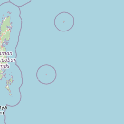
Map view of Kwangtung Island Wildlife Sanctuary

Use this park location map to pinpoint Kwangtung Island Wildlife Sanctuary in India, understand its exact geographic position, and read its mapped placement within the surrounding landscape more clearly.

Pigeon | © OpenStreetMap contributors

Location context for Kwangtung Island Wildlife Sanctuary

Andaman and Nicobar Islands
Park atlas

Compare adjacent island reserves and regional protected landscapes across North Andaman

Parks Near Kwangtung Island Wildlife Sanctuary and Surrounding Protected Areas

Browsing other parks near Kwangtung Island Wildlife Sanctuary reveals connected tropical forest habitats and coastal wildlife reserves across the archipelago. Expanding the geographic comparison provides essential context on regional conservation networks and protected island terrain.
National parkIndia
About 23 km away#1 closest

South

Saddle Peak National Park: Mapped Boundaries and National Park Geography

Explore India's protected landscapes and regional terrain.

Saddle Peak National Park stands as a distinct national park within India, offering rich opportunities for geographic exploration. Examine its mapped boundaries and understand its specific landscape characteristics. This entry serves as a vital point for comprehending the park's protected status and its contribution to the atlas of India's natural terrain.

Area
32.54 km²
Established
1979
IUCN
II
Relief
Mountain
Wildlife reserveAndaman and Nicobar Islands
About 41 km away#2 closest

South

Bamboo Island Wildlife Sanctuary: Mapping Coastal Protected Landscapes in the Andaman Archipelago

Coastal habitat, coral reefs, and littoral forest geography

Bamboo Island Wildlife Sanctuary represents a crucial protected area within the Andaman and Nicobar Islands, focusing on the interface between unique littoral bamboo thickets and surrounding marine reef environments. This reserve highlights the role of small island geography in conserving coastal stability and sensitive marine habitats within the Indian Bay of Bengal territory.

Area
0.05 km²
Established
1987
IUCN
IV
Relief
Lowland
Protected areaAndaman and Nicobar Islands
About 69 km away#3 closest

Southwest

Interview Island Protected Area: Geography, Forested Plateau, and Island Map

A remote wilderness sanctuary in the Andaman archipelago

Interview Island encompasses a secluded, 23 kilometer long landscape characterized by dense tropical forests and a rising southern plateau. This protected area stands out for its feral elephant population and near-undisturbed coastal environment, providing a compelling focus for geographic exploration and study of the Andaman island chain.

Area
101 km²
Established
1997
Relief
Upland
Water
Major water bodies
Wildlife reserveAndaman and Nicobar Islands
About 78 km away#4 closest

South

Cuthbert Bay Wildlife Sanctuary: Coastal Habitat and Sea Turtle Nesting Ground

Eastern Middle Andaman protected coastal geography

Cuthbert Bay Wildlife Sanctuary covers 5.8 square kilometres of critical coastal terrain along the eastern Middle Andaman coastline. Renowned for its concentration of sea turtle nesting beaches, the reserve supports diverse coastal ecosystems ranging from open sand to inland forest patches. It serves as a compact but vital ecological anchor within the broader landscape of the Andaman and Nicobar Islands.

Area
5.8 km²
Established
1997
IUCN
IV
Scope
Terrestrial
Wildlife reserveAndaman and Nicobar Islands
About 104 km away#5 closest

South

Flat Island Wildlife Sanctuary: Protected Island Geography in the Andaman and Nicobar Islands

Coastal wildlife reserve and isolated island terrain

Flat Island Wildlife Sanctuary stands as a distinct, low lying protected area within the Andaman and Nicobar Islands. Its compact oval shape and shoreline focused landscape provide a clear example of the archipelago's small scale, uninhabited marine reserves. This protected island serves as a vital geographic marker for those mapping the diverse coastal habitats found across the Bay of Bengal.

Area
2.48 km²
Relief
Lowland
Climate
Tropical
Access
Remote access
National parkAndaman and Nicobar Islands
About 121 km away#6 closest

South

North Button Island National Park: Protected Landscape and Mapped Geographic Identity

Explore the mapped boundaries and regional natural terrain.

Gain a clear understanding of North Button Island National Park as a distinct protected landscape within the Andaman and Nicobar Islands region. This entry offers detailed geographic context, focusing on the park's mapped boundaries and its role within the archipelago's natural terrain. It serves as a foundational element for understanding this Indian National Park's place in a broader atlas of conservation areas.

Area
114 km²
Established
1979
National parkAndaman and Nicobar
About 126 km away#7 closest

South

Middle Button Island National Park: National Park within Andaman and Nicobar's Geography

Explore protected landscape context and mapped park boundaries.

Middle Button Island National Park represents a significant protected natural landscape, offering users a focused entry point for geographic discovery. As a designated national park, it contributes distinct mapped boundaries and terrain characteristics to the Andaman and Nicobar region's atlas data. Understanding its specific identity helps contextualize the broader protected-area network and regional geography. This page details the park's role as a conserved territory, vital for those seeking structured landscape and geography information.

Area
64 km²
Established
1979
Relief
Lowland
Climate
Tropical
National parkAndaman and Nicobar Islands
About 131 km away#8 closest

South

South Button Island National Park: Mapped Boundaries and Regional Protected Landscape

Key National Park in the Andaman and Nicobar Islands

South Button Island National Park is a protected natural area offering critical insight into the geography of the Andaman and Nicobar Islands. This detailed view focuses on its mapped boundaries and its significance as a national park within this Indian archipelago. Understanding its position within the regional geography provides essential context for exploring protected lands and natural landscapes across the Andaman and Nicobar Islands.

Area
5 km²
Relief
Lowland
Climate
Tropical
Access
Moderate access

Common questions about visiting, size, designation, and location context for Kwangtung Island Wildlife Sanctuary

Kwangtung Island Wildlife Sanctuary FAQs for park facts, access, geography, and protected area context

Find quick answers about Kwangtung Island Wildlife Sanctuary, including protected-area facts, park geography, trail and visitor context, and how the park fits into its surrounding country and regional landscape.
MoriAtlas Explorer

Continue Your Protected Areas Search Across the Global Atlas

Deepen your exploration by continuing the structured search for national parks and protected areas worldwide. Utilize the comprehensive filtering capabilities to compare different conservation landscapes and refine your understanding of global park geography. Discover more about the distribution and characteristics of protected natural areas.

Global natural geography