Mori Atlas logo
Protected areaKysing Fjord

A study of regulated water systems, saltmarsh habitats, and coastal lagoon boundaries

Kysing Fjord Protected Area: Mapped Coastal Lagoon Geography in Region Midtjylland, Denmark

(Natura 2000-område nr. 59 Kysing Fjord (Fuglebeskyttelsesområde F30))

Kysing Fjord represents a distinct coastal lagoon system situated on the eastern coast of Jutland within Region Midtjylland. This protected landscape encompasses a mosaic of shallow tidal waters, saltmarsh meadows, and reclaimed agricultural terrain. The mapped boundaries provide a window into a carefully managed environment where riverine meadows along the Odder Å meet the Kattegat, serving as a significant wintering habitat for waterbirds.

coastal lagoonNatura 2000bird protection areawildfowl wintering areawhooper swan habitatsaltmarsh

Kysing Fjord

Protected area

Park overview

Structured park overview, official facts, and landscape profile for Kysing Fjord

Kysing Fjord park facts, protected area profile, and essential visitor context

Review the core facts for Kysing Fjord, including designation, size, terrain, visitor scale, habitats, and operating context in one park-focused overview.

About Kysing Fjord

Kysing Fjord, sometimes referred to by its core feature Norsminde Fjord, is a coastal Natura 2000 area located where the present shoreline of eastern Jutland meets the lower course of Odder Å. The protected area sits within the administrative area of Region Midtjylland and is shared between Odder Municipality, which covers the southern portion of the site, and Aarhus Municipality, which extends to the north. The site covers a total of about 370 hectares, a modest size that reflects its character as a compact but ecologically rich coastal landscape rather than a large wilderness reserve.

Much of the original fjord basin no longer exists as open water, having been reclaimed and converted to farmland decades ago. Today the surviving aquatic element is the three kilometer long Norsminde Fjord, a very shallow coastal lagoon with an average depth of only around sixty centimeters. Because of the sluice at Norsminde, which closes automatically when the sea rises more than 35 centimeters above mean water level, the lagoon is essentially a regulated environment. Water levels and salinity are managed to support agriculture on the adjacent reclaimed lands, but the same management creates predictable and stable conditions for waterbirds that rely on the area in winter.

Around and below the lagoon, the protected landscape includes saltmarsh meadows on former fjord bottom south of the current shoreline, as well as the wet meadows and lower course of Odder Å where the small river approaches the coast. These transitional habitats connect the open lagoon to the agricultural hinterland and provide feeding and roosting opportunities for waterfowl beyond the open water itself. Together, the lagoon, the saltmarsh, the river meadows, and the reclaimed farmland form a layered coastal system in which natural and human-modified elements interact continuously.

Kysing Fjord has been recognized as ecologically significant for more than eight decades. The area has been a designated wildlife reserve since 1942, and a 50 hectare stretch of saltmarsh and reclaimed farmland adjacent to the present fjord was placed under formal conservation order in 1970. With the creation of the EU Natura 2000 network, the site was formally listed as Fuglebeskyttelsesområde F30, primarily for the protection of the whooper swan, which winters here in nationally significant numbers. The Natura 2000 plan covering the area was adopted in 2011, and ongoing planning ties the site's nature management to the broader water plan for the Horsens Fjord main catchment area.

Quick facts and research context for Kysing Fjord

Kysing Fjord is a Danish Natura 2000 site covering roughly 370 hectares within Region Midtjylland, spanning parts of Odder and Aarhus municipalities. Its core feature is the shallow Norsminde Fjord, a coastal lagoon with an average depth of about 60 centimeters, where water level and salinity are regulated by an automatic sluice at Norsminde. The area has held wildlife reserve status since 1942 and is designated as EU Fuglebeskyttelsesområde F30 for the protection of the whooper swan. A 50 hectare portion of former fjord bed south of the present lagoon was placed under conservation order in 1970 as saltmarsh and reclaimed farmland.

Protection and recognition

Examine the documented conservation scope and Natura 2000 framework for Kysing Fjord.

Kysing Fjord Protection Status and International Recognition Records

Kysing Fjord features mixed protection scopes and verified Natura 2000 recognition sources governing its natural area. Review the documented conservation framework and formal designation records associated with this landscape.

International recognition

Protection details

Protection scope
Mixed
Transboundary protection
No
Park context

Deeper park guide and search-rich context for Kysing Fjord

Kysing Fjord history, landscape, wildlife, and travel context

Explore Kysing Fjord through its history, landscape character, ecosystems, wildlife, conservation priorities, cultural context, and seasonal travel timing in a structured park guide built for atlas discovery and search intent.

Why Kysing Fjord stands out

Kysing Fjord is best known as a wintering and staging area for the whooper swan, which occurs regularly throughout the cold season and has grown more numerous in the area since the 1990s. The site is also notable as the largest coastal lagoon in the former Aarhus County region, a habitat type that is prioritized under the EU Habitats Directive. The combination of a regulated shallow lagoon, surrounding saltmarsh, and adjacent agricultural lands creates a distinctive mix of habitats within a very small footprint on the eastern Jutland coast.
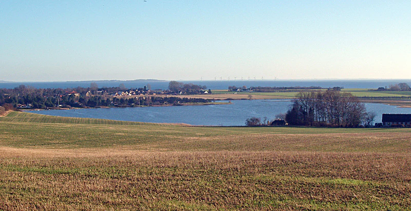
A wide landscape view of Norsminde Fjord, with open farmland in the foreground and a blue, calm body of water leading to the horizon.
A wide view overlooking Norsminde Fjord and surrounding agricultural fields.

Kysing Fjord history and protected-area timeline

The landscape history of Kysing Fjord is closely tied to centuries of land reclamation along the eastern Jutland coast. The original fjord basin was substantially larger than the present lagoon, but over time large areas were diked and drained to create agricultural land. As a result, much of what was once open water is now farmland lying at or just above sea level, while only a narrow southern reach, today's Norsminde Fjord, remains as open water.

Formal protection of the surviving natural values began in 1942, when Norsminde Fjord was established as a wildlife reserve. This early designation recognized the importance of the lagoon for waterbirds at a time when European wetland conservation was still a relatively new concept. In 1970, a 50 hectare section of former fjord bed south of the present lagoon, comprising saltmarsh and reclaimed arable land, was placed under a conservation order, extending protection onto the terrestrial margins of the system.

The site's modern identity is defined by its inclusion in the EU Natura 2000 network. As Fuglebeskyttelsesområde F30, the area is designated primarily for the whooper swan. The Danish Natura 2000 plan for the area was adopted in 2011, after which the municipalities and the Danish Nature Agency developed binding action plans for implementation. Subsequent planning periods have continued and developed this framework, with the natural area management coordinated alongside the water plan for the Horsens Fjord catchment area to the south.

Kysing Fjord landscape and geographic character

The landscape of Kysing Fjord is shaped by its position at the edge of the Jutland coast, where low-lying land meets the Kattegat. The visible centerpiece is the Norsminde Fjord, a very shallow coastal lagoon roughly three kilometers in length, separated from the open sea by a narrow barrier and connected to it only through the controlled sluice at Norsminde. Because the average depth is only around sixty centimeters, the lagoon reads more as an expansive shallow water and mudflat environment than as a true fjord.

Surrounding the lagoon is a mosaic of saltmarsh meadows, reclaimed former fjord bed, and the wet meadows along the lower Odder Å as the river reaches the coast. In the wider view, the surrounding terrain is largely flat agricultural land, with the settlements of Norsminde and the broader Odder and Aarhus hinterland framing the site. Looking north across the lagoon from Norsminde, views open toward the island of Tunø and the offshore wind turbines at Tunø Knob on the horizon, anchoring the lagoon visually within the larger coastal seascape of eastern Jutland.

The result is a quiet, low-relief coastal landscape in which saline mudflats, tidal-influenced saltmarsh, freshwater river meadows, and intensively farmed reclaimed land all sit within a short distance of each other. The defining impression is one of subtle transitions rather than dramatic relief, with the controlled sluice and the surrounding dikes serving as quiet reminders of how actively the boundary between land and sea has been managed here.

Kysing Fjord ecosystems, habitats, and plant life

Ecologically, Kysing Fjord is defined first and foremost by its coastal lagoon habitat. The site includes the prioritized habitat type coastal lagoons, recognized under the EU Habitats Directive, even though that specific habitat type is not formally part of the designation basis because the area is classified as a bird protection site rather than a habitat protection site. The very shallow brackish water combined with extensive mudflats supports a rich community of invertebrates, plants, and small fish that in turn sustain large numbers of overwintering waterbirds.

The saltmarsh and wet meadows around the lagoon add further ecological value. These areas act as buffers between the open lagoon and the surrounding agricultural land, providing feeding habitat, high-tide refuges, and nesting cover for a range of bird species. The lower Odder Å corridor links the lagoon to the freshwater system inland, creating a transition zone between freshwater, brackish, and marine influences across a small geographic area.

Although the surrounding matrix is heavily influenced by agriculture, the combination of regulated water levels, protected saltmarsh, and wildlife reserve status has maintained the ecological character of the lagoon over many decades. The system continues to function as a coherent coastal wetland complex, despite its small size and the long history of human modification around it.

Kysing Fjord wildlife and species highlights

Kysing Fjord is most strongly associated with waterbirds, particularly wintering and migratory species that use the shallow lagoon and surrounding meadows. The whooper swan is the species for which the area is formally designated as a Natura 2000 bird protection site. It occurs regularly throughout the winter half-year, and records between 1993 and 2005 documented a marked increase in numbers using the area, attributed both to a general population recovery across Europe and to a series of milder Danish winters that reduce the urge to migrate further south.

During winter, whooper swans in this area feed mainly on winter-green agricultural fields with crops such as rapeseed, wheat, or grass, rather than relying on vegetation in the open lagoon itself. This behavior links the swans closely to the surrounding farmland and demonstrates how the protected site functions not as an isolated natural reserve but as part of a working coastal landscape.

Beyond swans, the wider setting as a shallow coastal lagoon, saltmarsh, and river-mouth environment makes the site valuable for ducks and coots more broadly. The area is described as an important overwintering and resting area for ducks and coots in general, although the formal Natura 2000 designation focuses specifically on the whooper swan.

Kysing Fjord conservation status and protection priorities

Kysing Fjord carries layered conservation significance, combining national and European designations on a very small footprint. Its earliest protection dates to 1942, when Norsminde Fjord was established as a wildlife reserve, and a further 50 hectares of saltmarsh and former fjord bed were placed under conservation order in 1970. These long-standing protections predate the EU Natura 2000 framework by decades and reflect continuing national recognition of the site's ecological value.

At the European level, the area is listed as Fuglebeskyttelsesområde F30 under the EU Birds Directive, primarily because of its importance for the whooper swan. Although coastal lagoons are themselves a prioritized habitat type under the EU Habitats Directive, this site is not formally designated as a habitat area, and so that habitat is not part of the formal designation basis. Nonetheless, the lagoon's presence underlies much of the site's ecological significance.

The Natura 2000 plan adopted in 2011 set the current management framework, with binding action plans developed by the municipalities and the Danish Nature Agency. Conservation management is closely coordinated with the water plan for the Horsens Fjord main catchment, recognizing that the lagoon's ecological condition depends on how the wider hydrological system is managed. The continued importance of the site for overwintering waterbirds, particularly the whooper swan, makes Kysing Fjord a meaningful, if compact, contributor to Denmark's network of protected coastal wetlands.

Kysing Fjord cultural meaning and human context

The cultural context of Kysing Fjord is closely bound up with the long history of land reclamation and water management along the eastern Jutland coast. The shrunken size of the present lagoon reflects generations of dike construction and drainage that converted former fjord bed into productive farmland, a transformation that is itself a central part of the regional cultural landscape of this part of Denmark.

The village of Norsminde, where the regulating sluice is located, is a focal point of this human-nature relationship. The sluice, which closes automatically when sea levels exceed a defined threshold, represents a modern, technical expression of an older relationship in which local communities carefully managed the boundary between productive land and tidal saltwater. The lower Odder Å, which enters the lagoon at this point, adds a freshwater cultural thread, connecting inland farming traditions with the coastal environment.

The offshore visibility of Tunø and the Tunø Knob wind farm in views across the lagoon also places the site within a wider narrative of energy and coastal development in Denmark. While these modern elements are not part of formal cultural heritage designations, they help frame the area as a working coastal landscape where nature protection, agriculture, and infrastructure coexist.

Top sights and standout views in Kysing Fjord

Kysing Fjord stands out for the density of ecological and protective roles packed into a very small area. In roughly 370 hectares it combines a regulated shallow coastal lagoon, saltmarsh meadows, the lower river meadows of Odder Å, and surrounding agricultural land, all under multiple layers of conservation protection.

The site's defining highlights are its long-standing designation as a wildlife reserve dating back to 1942, its role as a nationally important wintering area for the whooper swan, and its status as the largest coastal lagoon in what was historically Aarhus County. It also illustrates how Natura 2000 protection can operate alongside active agriculture and water management, rather than in opposition to them.

Best time to visit Kysing Fjord

As a bird-focused protected area, Kysing Fjord is most interesting during the winter half-year, when the whooper swan and other waterfowl use the lagoon and surrounding fields. Whooper swans are recorded as regular winter visitors, with numbers in the area having grown during periods of milder winters.

For visitors interested in observing the wider waterbird community and the character of the shallow lagoon, cold-season visits tend to offer the richest wildlife experiences, although any season will reveal the basic qualities of this compact coastal lagoon landscape. The surrounding agricultural land and the views across to Tunø and the offshore wind turbines at Tunø Knob remain accessible year-round, with the shifting light and water conditions of the shallow lagoon providing a different atmosphere in each season.

Monthly climate preview

Long-term representative point measurements for regional weather by month

Kysing Fjord Climate Normals, Annual Temperature and Precipitation Rhythm

Representative coordinates record mean temperatures ranging from near freezing to mild summer highs alongside steady monthly precipitation levels. Reviewing complete twelve-month normals reveals precise long-term temperature ranges and precipitation patterns across the protected landscape.
Annual mean8 °C
1 °C17 °C
Jan
Feb
Mar
Apr
May11°
Jun14°
Jul17°
Aug17°
Sep13°
Oct
Nov
Dec
Warmest month
July

16.7 °C

Coolest month
February

0.9 °C

Wettest month
October

2.7 mm/day

Driest month
April

1.5 mm/day

Park location guide

Geography guide, regional context, and park location map for Kysing Fjord

Kysing Fjord park geography, regions, and map view in Denmark

Understand where Kysing Fjord sits in Denmark through a broader geographic reading of the surrounding landscape, nearby location context, and its mapped position within the national park landscape.

How Kysing Fjord fits into Denmark

Denmark is a constitutional monarchy and Nordic country in Northern Europe. It is the southernmost of the Scandinavian countries, bordering Germany to the south, Norway to the north, and Sweden to the southwest. The country consists of the Jutland peninsula and an archipelago of islands, with Copenhagen as its capital and largest city. Denmark has a population of over 6 million and is characterized by flat, arable land, sandy coasts, and a temperate climate.

Wider geography shaping Kysing Fjord in Denmark

Denmark occupies the Jutland peninsula and roughly 406 islands in Northern Europe. It is situated between the North Sea to the west and the Baltic Sea to the east. The country borders Germany to the south and is connected to Sweden via the Øresund Bridge. Denmark is predominantly flat terrain with low elevation, the highest point being Møllehøj at 170.86 meters.

Map view of Kysing Fjord

Use this park location map to pinpoint Kysing Fjord in Denmark, understand its exact geographic position, and read its mapped placement within the surrounding landscape more clearly.

Pigeon | © OpenStreetMap contributors

Location context for Kysing Fjord

Region Midtjylland
Recorded earthquake history

Explore the Historical Earthquake Catalogue for Kysing Fjord

Browse the comprehensive collection of seismic events documented near Kysing Fjord. MoriAtlas provides this structured catalogue for users interested in reviewing historical earthquake records, including event magnitudes and epicentre proximity, within this specific coastal geography.

Kysing Fjord Earthquake History

Catalogued events

1 event

Strongest magnitude

Magnitude 3.2

Most recent event

May 30, 1995

This history includes earthquakes recorded inside the park or within 50 km of its borders

Explore photographic views of shallow waters, saltmarshes, and whooper swan habitats.

Kysing Fjord Photos and Coastal Landscape Scenery: Visualizing the Protected Lagoon

Visual documentation captures the shallow coastal lagoon, tidal saltmarshes, and low-relief terrain defining the protected environment. Reviewing these field photographs reveals how regulated water management and coastal ecosystems intersect across the Jutland coast.

A wide landscape view of Norsminde Fjord, with open farmland in the foreground and a blue, calm body of water leading to the horizon.

Park atlas

Compare coastal lagoons, saltmarshes, and wildlife reserves across eastern Jutland

Explore Parks Near Kysing Fjord and Surrounding Regional Protected Areas

Browsing other parks near Kysing Fjord reveals a wider network of coastal protected areas and managed wetlands throughout the surrounding regional landscape. Expanding the comparison across nearby natural terrain highlights distinct conservation models and wildlife habitats spanning the Danish coast.
A horizontal watercolor painting depicting a soft, rolling landscape with green grassy fields, small clusters of trees, and tall grasses in the foreground.
Protected areaCentral Denmark Region
9.9 km away#1 closest

South

Horsens Fjord, havet øst for og Endelave: Protected Coastal Landscape and Map Context

Mapping island habitats, reefs, and fjord geography in Denmark

Examine the geographic composition of Horsens Fjord, havet øst for og Endelave, a significant Natura 2000 site. This protected area connects inland fjord waters to open Kattegat coastlines, featuring a chain of islands, tidal sand flats, and submerged stone reefs that define this distinct ecological region.

Area
458.23 km²
Established
2011
Relief
Lowland
Climate
Temperate
A wide watercolor illustration of a lake surrounded by green trees and rolling hills, with a small tree and pink flowers in the foreground.
Nature reserveAarhus Kommune
About 16 km away#2 closest

Northwest

Brabrand Sø Nature Reserve: Mapped Geography of an Aarhus Glacial Tunnel Valley

Protected freshwater wetlands and urban green corridors in Denmark

Brabrand Sø represents a rare, shallow freshwater lake and wetland complex located at the edge of the Aarhus urban fabric. This nature reserve, formed within a post-glacial tunnel valley, remains a cornerstone of the regional landscape through its integration of bird habitats, drinking-water protection, and open meadow terrain. The area offers a profound look at how peri-urban green infrastructure sustains both ecological health and geological character in the Aarhus Kommune region.

Area
1.54 km²
Established
1959
Relief
Lowland
Climate
Temperate
A horizontal watercolor painting depicting a gentle, rolling green landscape with tall grasses in the foreground and soft hills in the background.
Protected areaAarhus Kommune
About 17 km away#3 closest

Northwest

Årslev Engsø Protected Area in Aarhus Kommune: Geographic and Wetland Map

Restored freshwater lake and ecological tunnel valley habitat

Årslev Engsø is a primary example of freshwater restoration located in the Aarhus Å valley of Denmark. This protected area features a shallow lake basin, managed wet meadows, and essential reed bed habitats that serve as a crucial filtering system for the downstream watershed. Through our mapped atlas, examine the terrain and geographic context of this wetland environment situated near the eastern Jutland coast.

Area
2.1 km²
Established
2003
Relief
Lowland
Climate
Temperate
Watercolor painting depicting a gentle, rolling green landscape leading to a distant blue sea under a pale sky.
Protected areaRegion Midtjylland
17 km away#4 closest

East

Nordby Bakker Protected Area: Glacial Moraine and Grasslands in Region Midtjylland

Coastal cliffs, dunes, and rare calcareous ecosystems

Nordby Bakker preserves one of the largest continuous dry grassland complexes in Denmark, set upon a prominent glacial terminal moraine. Located at the northern tip of Samsø, this protected area features a unique synthesis of coastal dunes, beach ridges, and inland lakes that support a distinct array of rare plant and insect species within the central Kattegat region.

Area
6.28 km²
Relief
Upland
Climate
Temperate
Scope
Mixed
Watercolor illustration showing rolling hills, a lake, pink flowering trees, and distant mountains
National parkDenmark
19 km away#5 closest

Northeast

Mols Bjerge National Park: Glacial Geography and Protected Terrain in Central Jutland

Mapping the coastal cliffs and rolling heathland of Denmark

Mols Bjerge National Park protects a sweeping mosaic of glacial hills, woodlands, and coastal zones on the Djursland peninsula. With a landscape shaped by ancient ice sheets, the park offers a detailed view into Denmark's geological history, preserved ancient barrows, and rich botanical diversity along the Kattegat sea.

Area
180 km²
Established
2009
IUCN
II
Relief
Upland
Watercolor painting of a calm coastal bay with soft, layered green hills in the distance and a pale shoreline in the foreground.
Protected areaDenmark
About 20 km away#6 closest

Northeast

Begtrup Vig Protected Area: Glacial Terrain and Coastal Geography in Denmark

Coastal landscape and regional protected area mapping

Begtrup Vig is a distinct coastal bay defined by its glacial history, stretching across the southern Djursland peninsula in Denmark. Within the broader Mols Bjerge national park framework, the area features varied topography including stony shores, sandy coves, and pastoral meadows. This record provides a focused look at the environmental boundaries and geographic significance of this protected habitat, bridging natural terrain with the regional landscape context.

Relief
Upland
Scope
Mixed
Water
Water-dominated
Season
Year-round
A horizontal watercolor illustration showing a calm coastal bay with grassy banks, winding water channels, and rolling hills in the background under a soft yellow sky.
Protected areaRegion Midtjylland
About 22 km away#7 closest

Northeast

Natura 2000-område nr. 51 Begtrup Vig og kystområder ved Helgenæs Geography and Maps

Coastal grasslands and marine habitats in Region Midtjylland

Examine the complex terrain of Natura 2000-område nr. 51 Begtrup Vig og kystområder ved Helgenæs, an expansive protected area characterized by its diverse coastal cliff systems and large calcareous grasslands. This site documents the evolution of the Kattegat shoreline through its unique recurved spits and lifted seabed formations, providing a window into the natural landscape history of the Helgenæs peninsula.

Area
17.71 km²
Established
2011
Relief
Lowland
Climate
Temperate
A minimalist watercolor painting showing a horizontal landscape of green islands and shoreline against a white background.
Protected areaDenmark
22 km away#8 closest

Southeast

Stavns Fjord Protected Area: An Atlas of Danish Coastal Landscapes

Mapping the islands and tidal flats of Samsø

Stavns Fjord offers a rare glimpse into a sheltered coastal landscape set entirely within the island of Samsø. Characterized by its calm waters, shallow tidal flats, and the curving spit of Besser Rev, this protected site is a critical Ramsar wetland habitat for coastal bird populations. Explore the unique geography and layered history, from Viking canals to medieval fortifications, that define this essential Danish protected area.

Area
20 km²
Established
1926
Relief
Lowland
Access
Moderate access

Common questions about visiting, size, designation, and location context for Kysing Fjord

Kysing Fjord FAQs for park facts, access, geography, and protected area context

Find quick answers about Kysing Fjord, including protected-area facts, park geography, trail and visitor context, and how the park fits into its surrounding country and regional landscape.
MoriAtlas Explorer

Continue Your Protected Areas Search Across the Global Atlas

Deepen your exploration by continuing the structured search for national parks and protected areas worldwide. Utilize the comprehensive filtering capabilities to compare different conservation landscapes and refine your understanding of global park geography. Discover more about the distribution and characteristics of protected natural areas.

Global natural geography