
Mori Atlas logo
Nature reserveLadeburger Schaeferpfuhle

A post-glacial lowland fen reserve featuring wet meadows and diverse amphibian habitats

Ladeburger Schaeferpfuhle: Exploring the Protected Fen Landscapes of Barnim District

Ladeburger Schaeferpfuhle represents a distinctive post-glacial lowland fen complex situated west of Ladeburg in the Barnim District of Germany. This protected nature reserve encompasses wet meadows, extensive sedge beds, and a network of small standing water bodies that provide critical habitat for endangered amphibian and bird species. The mapped terrain showcases the unique hydrological character of the regional landscape, highlighting the ecological value of these threatened fen ecosystems within Brandenburg.

nature reservelowland fenwet meadowsedge bedamphibian habitatbird habitat
A flat vector-style illustration of a large mountain waterfall cascading down rocky cliffs into a stream, surrounded by a coniferous forest under a cloudy sky.

Ladeburger Schaeferpfuhle

Nature reserve

Park overview

Structured park overview, official facts, and landscape profile for Ladeburger Schäferpfühle

Ladeburger Schäferpfühle park facts, protected area profile, and essential visitor context

Review the core facts for Ladeburger Schäferpfühle, including designation, size, terrain, visitor scale, habitats, and operating context in one park-focused overview.

About Ladeburger Schäferpfühle

Ladeburger Schäferpfühle is a compact but ecologically rich nature reserve in the Barnim district of Brandenburg, just outside Berlin. The site lies west of the village of Ladeburg, which belongs to the town of Bernau bei Berlin, and forms part of the broader Naturpark Barnim. Although the reserve is small, covering about 26.68 hectares, it preserves a landscape type that has become increasingly rare across the Barnim plateau: a post-glacial complex of lowland fens, wet and fresh meadows, large sedge beds, and small open waters set within a matrix of willow and alder buckthorn shrub communities.

The reserve's character is defined by its hydrology and its openness. The numerous small pools scattered through the meadows and sedge beds create a transitional zone between aquatic and terrestrial habitats, supporting amphibians that depend on shallow, sun-warmed water for breeding as well as meadow-breeding birds and migratory species that use the area as a seasonal stopover. Grazing by Galloway cattle has been introduced to keep the meadows open and prevent the gradual encroachment of shrubs that would otherwise alter the habitat balance of the site.

Within the regional conservation framework of Brandenburg, Ladeburger Schäferpfühle plays a focused but meaningful role. It complements a series of other nature reserves that, together with the Unteres Odertal National Park and the larger Naturpark Barnim, maintain the patchwork of wetland, forest, and open-land habitats that defines the natural heritage of the area around Berlin.

Quick facts and research context for Ladeburger Schäferpfühle

Ladeburger Schäferpfühle is a Naturschutzgebiet of about 26.68 hectares, located west of Ladeburg within the municipality of Bernau bei Berlin in the Landkreis Barnim of Brandenburg. The reserve was legally established on 19 December 2000 and lies within the boundaries of the Naturpark Barnim. Its core feature is a post-glacial flachmoor (lowland fen) complex typical of the Barnim region, accompanied by wet and fresh meadows, large sedge communities, willow and alder buckthorn shrub formations, and numerous small pools. The site is maintained through seasonal grazing with Galloway cattle to prevent shrub encroachment.

Protection and recognition

Terrestrial protected area records and formal international recognition data

Ladeburger Schaeferpfuhle Protection Status and Documented Conservation Scope

Ladeburger Schaeferpfuhle maintains a recorded terrestrial conservation scope with verified institutional protection frameworks. Official records assemble documented management status and designation details for thorough geographical evaluation.

Protection details

Protection scope
Terrestrial
Transboundary protection
No
Park context

Deeper park guide and search-rich context for Ladeburger Schäferpfühle

Ladeburger Schäferpfühle history, landscape, wildlife, and travel context

Explore Ladeburger Schäferpfühle through its history, landscape character, ecosystems, wildlife, conservation priorities, cultural context, and seasonal travel timing in a structured park guide built for atlas discovery and search intent.

Why Ladeburger Schäferpfühle stands out

The reserve is best known for its post-glacial lowland fen ecosystem and its importance as a refuge for the fire-bellied toad (Bombina bombina), the heraldic species of the Naturpark Barnim. These small pools and meadows together provide breeding and resting habitat for a range of threatened amphibians, meadow-breeding birds, and migratory species, giving the protected area an outsized conservation value relative to its modest size.
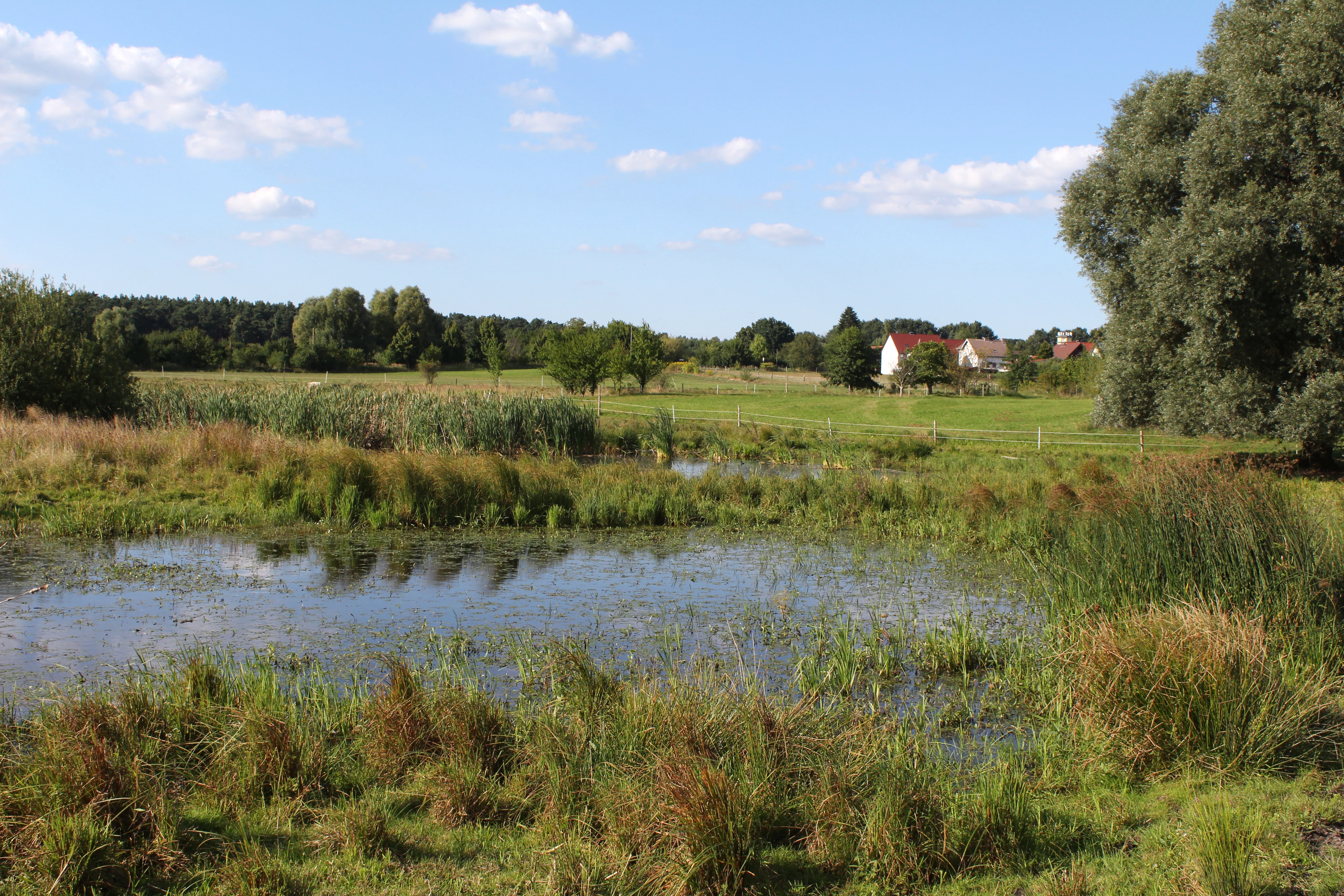
A peaceful landscape view of a nature reserve featuring a small pond in the foreground with grasses and wetland vegetation, leading into open fields and a distant row of trees under a clear blue sky.
A view across the Ladeburger Schaeferpfuhle nature reserve, highlighting the fen landscape and surrounding vegetation.

Ladeburger Schäferpfühle history and protected-area timeline

Ladeburger Schäferpfühle was formally protected on 19 December 2000, when the responsible Brandenburg authorities declared the area a Naturschutzgebiet. The designation aimed to preserve a post-glacial lowland fen complex that had been recognized as a representative and increasingly threatened habitat type of the Barnim region, particularly valuable for vulnerable plant communities, rare bird species, and amphibians.

Following its designation, management of the reserve has included measures to maintain the open character of the meadows, most notably the introduction of regular grazing with Galloway cattle. This grazing regime responds to a long-running ecological concern: without disturbance, the wet and fresh meadows of the reserve would gradually succumb to shrub encroachment from willow and alder buckthorn, narrowing the habitat available for the fen plant communities and the wildlife that depend on them.

Ladeburger Schäferpfühle landscape and geographic character

The landscape of Ladeburger Schäferpfühle is that of a gently undulating lowland fen on the Barnim plateau. The terrain is flat to slightly rolling, shaped by the retreat of the last ice sheets, which left behind the moist basin conditions that still define the site's hydrology today. Streams are absent; instead, the area is threaded with numerous small standing water bodies, pools, and saturated zones that punctuate the surrounding meadows.

Vegetation defines the visual character of the reserve. Wide stretches of wet and fresh meadows alternate with extensive large sedge beds, while colonies of willows and alder buckthorn form low, dense thickets along the wetter margins. The combination of open water, sedge-dominated ground, and scattered shrub patches gives the area an intimate, mosaic-like appearance. The open, grazed meadows provide broad, light-filled vistas, and the contrast between the lush green of spring and summer growth and the exposed pools and damp ground in the colder months gives the reserve a strong seasonal rhythm.

Ladeburger Schäferpfühle ecosystems, habitats, and plant life

Ecologically, Ladeburger Schäferpfühle is shaped by its fen character. The soils remain saturated for much of the year, producing a plant community dominated by moisture-loving species. Large sedge communities (Grossseggenriede) are a defining element, alongside more conventional wet and fresh meadow types and shrubby communities of willows and alder buckthorn that mark the transitions to drier ground.

Among the meadow plants, the broad-leaved marsh orchid (Dactylorhiza majalis) and the ragged robin (Lychnis flos-cuculi) are characteristic species, illustrating how the fen meadows continue to host flowering plants associated with traditional, unfertilized wet grassland. The ecological value of the reserve depends heavily on keeping these meadow communities open, which is why grazing with Galloway cattle has become a central management tool, countering the natural tendency of willows and buckthorn to expand and turn the open fen into scrub.

Ladeburger Schäferpfühle wildlife and species highlights

The wildlife of Ladeburger Schäferpfühle is closely tied to its mosaic of small pools, sedge beds, and open meadows. The most emblematic species is the fire-bellied toad (Bombina bombina), a Red List amphibian in Brandenburg and the symbolic species of the Naturpark Barnim. The numerous small waters make the reserve a vital breeding habitat for this and other amphibians whose populations have declined across much of the surrounding landscape.

The meadows and shrubs also support a rich bird community. The area functions as breeding and resting habitat for a range of Red List bird species, as well as for migratory birds passing through the Barnim region in spring and autumn. White storks (Ciconia ciconia), which nest in nearby Ladeburg, are regular summer visitors that come to the wet meadows to forage, a seasonal presence that has become a familiar feature of the local landscape in the warmer months.

Ladeburger Schäferpfühle conservation status and protection priorities

The conservation significance of Ladeburger Schäferpfühle lies in its role as a refuge for a fen-type habitat that has become rare and fragmented across the Barnim region. The reserve protects a post-glacial flachmoor complex that supports threatened plant communities as well as rare and endangered amphibian and bird species, including several that appear on the Brandenburg Red List.

As part of the Naturpark Barnim, the reserve also contributes to the broader conservation network of Brandenburg's countryside, linking with other protected areas such as the Fauler Wiesen bei Bernau, the Biesenthaler Becken, and the Unteres Odertal National Park further north. Management is deliberately light-touch and oriented toward habitat maintenance: grazing with Galloway cattle keeps the meadows open, while the existing pools and sedge beds are preserved as breeding and resting habitat for amphibians and birds whose survival depends on intact small-scale wetland refuges like this one.

Top sights and standout views in Ladeburger Schäferpfühle

Ladeburger Schäferpfühle offers a compact but well-defined example of a Barnim lowland fen, with its characteristic mix of wet meadows, large sedge beds, willow and alder buckthorn communities, and a network of small pools. The reserve is notable for the fire-bellied toad, a Red List amphibian and the symbolic species of the Naturpark Barnim, as well as for its population of threatened meadow-breeding and migratory birds. Seasonal grazing by Galloway cattle keeps the meadows open and ensures that the fen plant communities, including broad-leaved marsh orchid and ragged robin, continue to thrive.

Best time to visit Ladeburger Schäferpfühle

The character of Ladeburger Schäferpfühle changes with the seasons in ways that reflect its fen ecology. Late spring and early summer are particularly rewarding, when the wet meadows come into flower, the numerous small pools are most active for breeding amphibians, and grazing cattle are typically present on the grasslands. Migratory and breeding birds are also at their most visible during this period, and white storks can frequently be seen foraging on the meadows.

In summer, the dense green of the sedge beds and shrubs contrasts with the reflective surfaces of the pools, while autumn brings migratory birds passing through the Barnim landscape. Winter exposes the open structure of the wet meadows and the network of pools, making the underlying hydrology of the fen easier to read in the landscape. A site visit is best approached as a calm, observational experience rather than an active excursion, given the reserve's modest size and sensitive habitats.

Monthly climate preview

Long-term representative monthly temperature and precipitation rhythm

Ladeburger Schaeferpfuhle Climate Normals and Annual Weather Patterns

Ladeburger Schaeferpfuhle records measured average temperatures ranging from sub-zero winter minimums to warm summer maximums alongside steady daily precipitation values. Reviewing these multi-year representative point measurements clarifies the broader environmental rhythm across all twelve months.
Annual mean9 °C
-1 °C20 °C
Jan-1°
Feb
Mar
Apr
May14°
Jun18°
Jul20°
Aug20°
Sep15°
Oct
Nov
Dec
Warmest month
July

20.3 °C

Coolest month
January

-0.9 °C

Wettest month
July

2.4 mm/day

Driest month
April

1.1 mm/day

Park location guide

Geography guide, regional context, and park location map for Ladeburger Schäferpfühle

Ladeburger Schäferpfühle park geography, regions, and map view in Germany

Understand where Ladeburger Schäferpfühle sits in Germany through a broader geographic reading of the surrounding landscape, nearby location context, and its mapped position within the national park landscape.

How Ladeburger Schäferpfühle fits into Germany

Germany is a federal republic in Western and Central Europe with a population of over 83 million across sixteen constituent states. It is Europe's largest economy by nominal GDP and a major global exporter and importer. The capital is Berlin, and the country borders Denmark, Poland, Czech Republic, Austria, Switzerland, France, Luxembourg, Belgium, and the Netherlands.

Wider geography shaping Ladeburger Schäferpfühle in Germany

Germany is located in Western and Central Europe, spanning 357,022 km². It borders Denmark to the north, Poland and the Czech Republic to the east, Austria and Switzerland to the south, and France, Luxembourg, Belgium, and the Netherlands to the west. The country has coastlines on the Baltic Sea and North Sea to the north, with the Alps located in the southern region.

Map view of Ladeburger Schäferpfühle

Use this park location map to pinpoint Ladeburger Schäferpfühle in Germany, understand its exact geographic position, and read its mapped placement within the surrounding landscape more clearly.

Pigeon | © OpenStreetMap contributors

Location context for Ladeburger Schäferpfühle

Barnim District

Visual exploration of post-glacial lowland fens and wetland habitats

Ladeburger Schaeferpfuhle Photos and Landscape Scenery

Visual documentation of Ladeburger Schaeferpfuhle reveals the distinct post-glacial terrain and wet meadow habitats defining the Barnim plateau. Examining these protected area images provides clear insight into the local ecosystem character and seasonal vegetation patterns.

A peaceful landscape view of a nature reserve featuring a small pond in the foreground with grasses and wetland vegetation, leading into open fields and a distant row of trees under a clear blue sky.

Park atlas

Compare regional post glacial fen habitats and nearby conservation areas across Brandenburg

Exploring Parks Near Ladeburger Schaeferpfuhle and Surrounding Protected Landscapes

Browse other protected areas and wetland reserves located near Ladeburger Schaeferpfuhle in northeastern Germany. Continuing the geographic comparison reveals how surrounding post glacial fen ecosystems and lowland habitats connect across the wider Barnim plateau.
A horizontal watercolor illustration showing a pinkish-purple foreground of heathland vegetation transitioning into a line of light green trees against a pale, washed-out hilly background.
Nature reserveBrandenburg
About 3.3 km away#1 closest

West

Schönower Heide Nature Reserve: An Atlas View of Brandenburg Protected Heathlands

A restored landscape of glacial dunes and sandy heath

Schönower Heide stands as a significant nature reserve in Brandenburg, Germany. The area protects a unique combination of open sand heath, pine woodland, and wetland meadows formed on post-glacial outwash plains. This protected landscape is recognized for its successful transition from former military terrain into a vibrant habitat for diverse flora and fauna, including managed populations of red deer and mouflon within its fenced boundaries.

Area
5.334 km²
Established
2000
IUCN
V
Relief
Lowland
A watercolor illustration of a rural landscape with low hills, trees, and grassy meadow areas.
Nature reserveBrandenburg
About 4.6 km away#2 closest

Southwest

Faule Wiesen bei Bernau Nature Reserve: Mapped Landscapes and Geography of Brandenburg

A vital Panke river corridor protecting rare meadow and woodland biomes.

Spanning 37 hectares near the northern edge of Berlin, Faule Wiesen bei Bernau offers a study in contrasting landscapes. The reserve features open wet meadows and small ponds alongside sandy dry grasslands and oak woodlands. It remains an essential ecological link within the Barnim district, preserving critical habitats for amphibians and orchids within the broader Brandenburg geography.

Area
0.37 km²
Established
2000
Relief
Lowland
Scope
Terrestrial
A horizontal watercolor illustration of a wetland scene with soft pink and green tones, showing sparse trees on the banks of a shallow, marshy water area under a pale sky.
Nature reserveBrandenburg
About 7.2 km away#3 closest

Southwest

Ausstichgelände Röntgental: Brandenburg Nature Reserve and Protected Wetland Atlas

Mapped ecological landscapes on the Berlin metropolitan fringe

Investigate the detailed geography of Ausstichgelände Röntgental, a compact nature reserve in Brandenburg. Formed from nineteenth-century railway sand quarries, this protected area features a diverse mosaic of reed beds, open water, and alder carr forest. The site provides a compelling case study of post-industrial ecological recovery within the broader Barnim Nature Park landscape.

Area
0.248 km²
Established
1990
IUCN
IV
Watercolor illustration showing a soft landscape with a pond, marsh vegetation, and a background of rolling hills or meadows.
Nature reserveBerlin
About 7.9 km away#4 closest

Southwest

Mittelbruch Nature Reserve: Mapped Wetland Geography and Protected Landscape in Berlin

Examining lowland peat diggings and protected moorland ecosystems

Mittelbruch stands as a compact nature reserve in northeastern Berlin, featuring a layered landscape of former peat diggings and open moor meadows. This area plays a critical role in urban conservation by providing essential refuge for waterbirds and diverse meadow flora. Utilize the atlas to study the reserve's internal geography, including its managed reed belts and surrounding forest edges that form a distinct ecological mosaic within the city landscape.

Area
0.282 km²
Established
1997
IUCN
IV
Relief
Lowland
A horizontal watercolor painting depicting a marshy landscape with ponds, green vegetation, and soft distant hills against a light background.
Nature reserveBerlin
About 12 km away#5 closest

Southwest

Karower Teiche Nature Reserve: Mapped Protected Wetland Geography in Northeast Berlin

Transitional lowland fen and pond mosaic

Karower Teiche protects a unique 128 hectare wetland mosaic in the Pankow district of Berlin. Centered on four shallow ponds and extensive reedbeds, the reserve maintains a vital ecological corridor between the Barnim plateau and the Berlin glacial valley. This site provides essential habitat for amphibians and reed-specialist birds within an urban setting.

Area
1.286 km²
Established
1994
IUCN
IV
Relief
Lowland
A watercolor painting of a flat, marshy landscape with soft green trees in the midground and pale hills under a light sky in the background.
Nature reserveBerlin
About 13 km away#6 closest

South

Falkenberger Rieselfelder Nature Reserve: A Detailed Atlas of Berlin Protected Lands

Reclaimed wetland geography and urban conservation habitats

Falkenberger Rieselfelder acts as an ecologically rich refuge where former industrial irrigation fields have been repurposed into a mosaic of seasonal pools and meadows. Located on the urban fringe of Berlin, this nature reserve offers a unique look at how conservation grazing and habitat management support species like the great crested newt within a dense metropolitan region.

Area
0.881 km²
Established
1995
IUCN
IV
Relief
Lowland
A soft watercolor painting featuring green grasses in the foreground, calm water, and a tree line along the horizon.
Nature reserveBrandenburg
About 13 km away#7 closest

Southwest

Schönerlinder Teiche Nature Reserve in Brandenburg: Protected Landscape and Geographic Atlas

Explore the wetland mosaic, bird-rich ponds, and grazing conservation areas

Schönerlinder Teiche offers a rare look at post-agricultural land transformation, featuring ponds, meadows, and reed habitats in the Brandenburg region. This nature reserve serves as an essential bird sanctuary and educational site, with water buffalo and Konik horses contributing to ongoing habitat maintenance. View the detailed geography of this protected area and its role within the wider Barnim Nature Park network.

Area
0.408 km²
Established
1997
IUCN
IV
Relief
Lowland
Watercolor painting of a peaceful wetland landscape with lush green trees, reeds, and soft hills in the background under a light sky.
Nature reserveBerlin
About 14 km away#8 closest

Southwest

Malchower Aue Nature Reserve: A Detailed Atlas of Urban Protected Landscapes in Berlin

Wetland habitats and glacial terrain within the Berlin city limits.

Malchower Aue stands as a protected enclave of wetland diversity featuring a system of reed-fringed peat-cutting ponds, wet meadows, and rare dry-grassland vegetation on historical soil mounds. This site provides a vital geographic perspective on how post-glacial relief and human land-use history shape protected areas within the modern urban landscape of Berlin.

Area
0.222 km²
Established
1995
Relief
Lowland
Climate
Temperate

Common questions about visiting, size, designation, and location context for Ladeburger Schäferpfühle

Ladeburger Schäferpfühle FAQs for park facts, access, geography, and protected area context

Find quick answers about Ladeburger Schäferpfühle, including protected-area facts, park geography, trail and visitor context, and how the park fits into its surrounding country and regional landscape.
MoriAtlas Explorer

Continue Your Protected Areas Search Across the Global Atlas

Deepen your exploration by continuing the structured search for national parks and protected areas worldwide. Utilize the comprehensive filtering capabilities to compare different conservation landscapes and refine your understanding of global park geography. Discover more about the distribution and characteristics of protected natural areas.

Global natural geography