
Mori Atlas logo
Protected areaLaguna de Sayula

A comprehensive look at the volcanic terrain, migratory bird habitat, and ecological landscape of this central Mexican site

Laguna de Sayula Protected Area: Mapping the Endorheic Basin and Wetlands of Jalisco, Mexico

Laguna de Sayula is a large, endorheic salt lake situated within a tectonic depression in southern Jalisco, Mexico. Framed by the Sierra de Tapalpa and Sierra de Mazamitla, this site forms a vital part of the Neo-Volcanic Axis lake system. The protected area serves as an internationally recognized Ramsar wetland, offering a complex environment of saline flats, halophytic vegetation, and seasonal freshwater zones that host migratory North American waterbirds. Beyond its ecological value, the region is defined by a deep history of Indigenous salt production and extensive pre-Hispanic archaeological remains.

endorheic lakesalt lakewetlandRamsar sitemigratory birdswaterbird habitat
An artistic vector illustration showing a winding river flowing through a valley surrounded by purple and brown mountains under a pale sky.

Laguna de Sayula

Protected area

Park overview

Structured park overview, official facts, and landscape profile for Laguna de Sayula

Laguna de Sayula park facts, protected area profile, and essential visitor context

Review the core facts for Laguna de Sayula, including designation, size, terrain, visitor scale, habitats, and operating context in one park-focused overview.

About Laguna de Sayula

Laguna de Sayula is one of the most distinctive natural landmarks of southern Jalisco, occupying a broad shallow basin between the Sierra de Tapalpa and the Sierra de Mazamitla. It is part of the Zacoalco-Guzmán fault and lake system, a series of tectonic depressions along the Neo-Volcanic Axis of central Mexico that hosts several endorheic lakes. Because the basin has no natural outlet to the sea, the lake is highly dependent on local precipitation, runoff, and inflow from springs and small streams, and it can fluctuate significantly over time.

The lake rises to roughly 1,350 meters above sea level, giving it a moderate, semi-dry subtropical climate that shapes the vegetation patterns along its shores. With an average depth of only about 2 meters, it functions less as a deep open body of water and more as an extensive wetland complex, with salt flats, shallow margins, small freshwater pockets, and two low islands named Isla Chica and Isla Grande. The surrounding landscape transitions from halophytic, salt-tolerant plant communities along the shore to tropical deciduous forest on the surrounding hills and islands.

Ecologically, Laguna de Sayula is most significant for its birdlife. As a designated Ramsar site, it plays an important role in the conservation of North American migratory birds, providing seasonal habitat at a key point in central-western Mexico. Although the lake has experienced a gradual lowering of water levels since the early 1990s, it continues to support waterbirds, raptors, turtles, and a wide range of insects.

Culturally, the lake is embedded in a deep regional history. Archaeological evidence from around its shores points to long-term pre-Hispanic occupation and careful landscape management, including ancient terraced agriculture and the famous cuencos salineros, traditional earthen salt-extraction pits. These features, combined with the lake's scenic setting and ecological importance, give Laguna de Sayula a layered identity as both a natural protected area and a long-inhabited cultural landscape.

Quick facts and research context for Laguna de Sayula

Laguna de Sayula is an endorheic salt lake in southern Jalisco, Mexico, located about 60 km south of Guadalajara between the Sierra de Tapalpa and the Sierra de Mazamitla. Covering roughly 168 square kilometers at around 1,350 meters above sea level, it forms part of the Zacoalco-Guzmán tectonic and hydrological system along the Neo-Volcanic Axis.

The lake averages about 2 meters in depth, holds two small islands (Isla Chica and Isla Grande), and is fed by local streams and springs while losing water primarily through evaporation. It was designated a Ramsar Wetland on 2 February 2004 in recognition of its importance to migratory waterbirds, and lies within a region rich in pre-Hispanic archaeological sites associated with Indigenous salt production.

Protection and recognition

Documented terrestrial protected area designation history and Ramsar wetland recognition

Laguna de Sayula Protection Status and International Recognition

Terrestrial conservation records establish the protected area designation history and management scope for Laguna de Sayula from 2004 onward. Official international recognition data highlights the formal Ramsar wetland listing associated with this natural site.

International recognition

Protection details

Protection scope
Terrestrial
Designated year
2004
Transboundary protection
No
Park context

Deeper park guide and search-rich context for Laguna de Sayula

Laguna de Sayula history, landscape, wildlife, and travel context

Explore Laguna de Sayula through its history, landscape character, ecosystems, wildlife, conservation priorities, cultural context, and seasonal travel timing in a structured park guide built for atlas discovery and search intent.

Why Laguna de Sayula stands out

Laguna de Sayula is best known as a high-elevation salt lake that serves as an important stopover for migratory North American birds. Its Ramsar designation in 2004 reflects the lake's international significance for waterbird conservation along a key flyway in central-western Mexico. The lake is also recognized for its setting within a closed basin bordered by volcanic mountain ranges, which gives it a distinct endorheic character. Salt-tolerant vegetation and tropical deciduous forest surrounding the lake add ecological complexity, while the lake's long history of human use, especially Indigenous salt harvesting going back more than two millennia, makes it a notable cultural as well as ecological landmark of Jalisco.
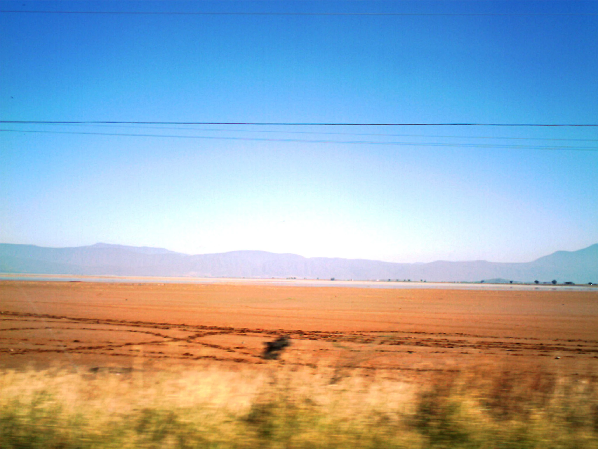
A vast, flat, and dry orange-toned landscape under a clear blue sky, with a hazy mountain range visible in the distant background.
A wide view of the dry lakebed at Laguna de Sayula in Jalisco, Mexico.

Laguna de Sayula history and protected-area timeline

Laguna de Sayula has a long pre-Hispanic history of human settlement around its shores, dating back more than two thousand years. Archaeological research in the region has identified four major occupation phases: the Usmajac phase (roughly 200 BCE to 200 CE), the Verdía phase (approximately 0 to 450 CE), the Sayula phase (450 to roughly 1100 CE), and the Amacueca phase (1100 to around 1530 CE).

During the Sayula phase, communities organized monumental architecture, expanded agricultural terracing, and developed an industry based on extracting salt from the lake margins. Their iconic cuencos salineros Sayula; bowl-shaped earthen pits used to concentrate brine and harvest salt, became a defining feature of the local economy. Throughout all these phases, the lake served as a center of settlement, resource extraction, and regional exchange.

In the late pre-Hispanic period, the surrounding region was incorporated into the Tarascan sphere of influence, leaving traces of broader Mesoamerican connections in the archaeological record. Today, more than 170 archaeological sites have been documented around the lagoon, several of which show evidence of planned urban layouts, making the Laguna de Sayula basin one of the most archaeologically dense lake settings in Jalisco.

In modern times, recognition of the lake's ecological importance culminated on 2 February 2004, when it was designated a Ramsar Wetland of international importance. This formal protection highlights the lake's continuing role as habitat for migratory birds and acknowledges the slow environmental changes, especially the gradual decline in water levels since the 1990s, that have affected the basin.

Laguna de Sayula landscape and geographic character

Laguna de Sayula occupies a broad, shallow tectonic depression in central-western Mexico, framed dramatically by the Sierra de Tapalpa to the west and the Sierra de Mazamitla to the east. This setting, within the larger Zacoalco-Guzmán system of faults and basins, places the lake among a chain of endorheic basins running along Mexico's Neo-Volcanic Axis.

At about 1,350 meters above sea level, the lake sits in a mid-elevation landscape characterized by rolling hills, volcanic terrain, and seasonal aridity. The shoreline is long and irregular, roughly 90 km in extent, and includes beaches of fine sediment, muddy flats, and shallow margins that gradually grade into halophytic vegetation zones. The two small islands, Isla Chica and Isla Grande, break the open surface of the lake and rise as low oval features of less than a square kilometer each.

Because the basin is closed, the lake does not drain outward to the sea; instead, it loses water through evaporation and depends on seasonal rainfall and local inflows from streams and springs. This produces a dynamic landscape where shallow saline margins, occasional freshwater pockets, and exposed flats all coexist within a relatively small geographic footprint, giving the lake a varied and visually rich shoreline.

Laguna de Sayula ecosystems, habitats, and plant life

Laguna de Sayula is a wetland ecosystem defined by the interplay of saline conditions, volcanic basin geography, and seasonal waterbird migration. Its Ramsar designation reflects its importance as a habitat for migratory birds traveling along North American flyways, and the wetland's character is shaped by the fact that water, more than soil or altitude, controls vegetation and animal life here.

Vegetation around the lake is strongly adapted to the saline environment. Halophytic plant communities dominate the immediate shoreline, with low-lying salt-tolerant grasses, succulents, and shrubs forming an important ecological buffer. Slightly inland and on the surrounding hills, including the two islands, tropical deciduous forest becomes more prominent, with mesquite, acacias, bursera, and fig trees forming characteristic canopies. Aquatic vegetation is limited and tends to concentrate in small pockets of fresher water within the otherwise saline lake.

As part of the closed Sayula-Atotonilco basin, the lake functions within a broader endorheic hydrological system where evaporation, not outflow, is the main water exit. This creates conditions that both concentrate salts and amplify the lake's sensitivity to climate variability, giving rise to an ecological system that is highly specialized and tightly adapted to its setting.

Laguna de Sayula wildlife and species highlights

The wildlife of Laguna de Sayula is characteristic of wetland and semi-arid environments in central Mexico, with a particularly strong seasonal component related to migratory birds. In winter, the lake is an important destination for North American migratory species, including snow geese (Chen caerulescens) and the killdeer (Charadrius vociferus), as well as other shorebirds that use the saline margins and shallow flats as feeding and resting habitat.

Beyond migratory visitors, the lake supports year-round populations of raptors, with eagles and hawks patrolling the open water and surrounding hills. Turtles are also reported in the lake and its margins, and a diverse insect community supports the broader food web of the wetland. Local reptiles, small mammals, and typical birdlife of the surrounding tropical deciduous forest further enrich the fauna of the area.

Although the lake has experienced gradual reduction in water levels since the early 1990s, its mix of saline flats, shallow water, islands, and adjacent forest continues to support a diversity of species that depends on this particular combination of habitats.

Laguna de Sayula conservation status and protection priorities

Laguna de Sayula's principal conservation significance lies in its role as an internationally recognized wetland for migratory birds. Its designation as a Ramsar site on 2 February 2004 confirmed its value as habitat for waterbirds along a major North American flyway and placed it within a global network of protected wetlands.

The lake's ecological importance is heightened by its position within an endorheic basin, making its water and salinity balance particularly sensitive. Gradual lowering of water levels since the 1990s has been a significant ecological concern, affecting the extent and quality of habitat available for both resident and migratory species. Conservation attention therefore focuses on preserving the wetland's hydrology, its halophytic vegetation, and the mosaic of habitats that together support its biodiversity.

Recognition of the area's archaeological richness, with more than 170 documented sites around the lake, has also contributed to a broader understanding of the basin as a landscape of both natural and cultural value. Together, these factors give Laguna de Sayula a dual profile as an ecological priority and a protected cultural landscape in Jalisco.

Laguna de Sayula cultural meaning and human context

Laguna de Sayula has been a center of human life in southern Jalisco for more than 2,000 years, with the surrounding basin containing an unusually high density of archaeological sites. The lake is closely associated with the pre-Hispanic tradition of salt extraction using the cuencos salineros, bowl-shaped earthen pits in which brine was concentrated and salt harvested, a practice tied especially to the Sayula phase (c. 450-1100 CE) but influential across the region.

Settlement around the lake evolved over four main occupational phases, from early agricultural communities of the Usmajac phase through the structured monumental architecture of the Sayula phase to the politically complex and more externally connected Amacueca phase. In its later pre-Hispanic stage, the region became part of the broader Tarascan sphere, an affiliation visible in ceramic styles and other archaeological evidence.

Today, the lake sits within a landscape of several municipalities, including Sayula, Amacueca, Techaluta de Montenegro, and Atoyac, and remains a defining element of local identity. Its combination of salt-making heritage, Indigenous settlement history, and ongoing ecological importance makes it a place where natural and cultural history continue to intersect visibly in the present-day landscape.

Top sights and standout views in Laguna de Sayula

Laguna de Sayula stands out as one of the few endorheic salt lakes in Jalisco with both Ramsar recognition and a major pre-Hispanic archaeological footprint. Its location between the Sierra de Tapalpa and the Sierra de Mazamitla gives it a visually distinct basin setting, while its shallow waters, small islands, and long irregular shoreline create a varied wetland environment within a relatively compact area.

The lake is a key seasonal destination for migratory waterbirds, and its saline margins support specialized halophytic vegetation that is unusual at this elevation. Layered on top of these natural features is a richer cultural heritage than most Mexican lakes of comparable size, shaped by centuries of Indigenous salt production and dense archaeological occupation around its shores.

Best time to visit Laguna de Sayula

Laguna de Sayula is most striking from late autumn through winter, when migratory North American birds, including snow geese and killdeer, arrive in the area and concentrate along the lake's shallow margins and saline flats. The cooler, drier months typically bring clearer skies and more comfortable conditions for exploring the surrounding basin, while also highlighting the muted tones of the halophytic shoreline vegetation.

Spring and early summer can produce greener surroundings as the tropical deciduous forest on the surrounding hills leafs out, but seasonal aridity and evaporation remain dominant in the lake basin. Because the lake has experienced gradual reductions in water levels since the 1990s, the precise extent and condition of wetland habitat can vary from year to year, influencing bird numbers and visibility at any given time.
Monthly climate preview

Long-term monthly temperature and precipitation data for Jalisco

Laguna de Sayula Climate Normals and Annual Temperature Patterns

Representative coordinates record measured monthly temperature and precipitation rhythms across the protected landscape. Full twelve-month climatology data provides deeper insight into historical weather patterns at the site.
Annual mean19 °C
15 °C23 °C
Jan15°
Feb17°
Mar19°
Apr21°
May23°
Jun22°
Jul20°
Aug20°
Sep20°
Oct19°
Nov17°
Dec16°
Warmest month
May

23 °C

Coolest month
January

15.4 °C

Wettest month
July

6.4 mm/day

Driest month
April

0.1 mm/day

Park location guide

Geography guide, regional context, and park location map for Laguna de Sayula

Laguna de Sayula park geography, regions, and map view in Mexico

Understand where Laguna de Sayula sits in Mexico through a broader geographic reading of the surrounding landscape, nearby location context, and its mapped position within the national park landscape.

How Laguna de Sayula fits into Mexico

Mexico, officially the United Mexican States, is a country in North America spanning the Sierra Madre mountain ranges, coastal plains, and tropical regions. It borders the United States to the north, Guatemala and Belize to the southeast, and has coastlines along the Pacific Ocean, Gulf of Mexico, and Caribbean Sea. With a population exceeding 130 million, Mexico is home to one of the world's most significant concentrations of Indigenous languages alongside Spanish.

Wider geography shaping Laguna de Sayula in Mexico

Mexico occupies a land area of 1,972,550 km2, making it the thirteenth-largest country in the world. The terrain is highly diverse, featuring the Sierra Madre Occidental and Sierra Madre Oriental mountain ranges, the Mexican Plateau, coastal lowlands along the Pacific and Gulf/Caribbean margins, and the Yucatan Peninsula. The country spans multiple climate zones from desert in the north to tropical rainforest in the south.

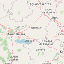
Map view of Laguna de Sayula

Use this park location map to pinpoint Laguna de Sayula in Mexico, understand its exact geographic position, and read its mapped placement within the surrounding landscape more clearly.

Pigeon | © OpenStreetMap contributors

Location context for Laguna de Sayula

Jalisco

Visualizing volcanic basin terrain, salt flats, and wetland habitats

Laguna de Sayula Photos and Landscape Scenery

Photographic records reveal the broad tectonic depression and saline shoreline defining Laguna de Sayula. Visual exploration of the protected basin illustrates endorheic lake features and migratory bird habitats across Jalisco.

A vast, flat, and dry orange-toned landscape under a clear blue sky, with a hazy mountain range visible in the distant background.

A vast, flat, and arid dry lake bed under a clear blue sky, with rolling mountains in the distance and visible power lines stretching across the top of the frame.

Park atlas

Compare adjacent volcanic basins, wetland habitats, and regional conservation landscapes

Parks Near Laguna de Sayula and Related Protected Areas in the Surrounding Region

Browse other protected areas and regional reserves located near Laguna de Sayula to compare neighboring wetland ecosystems across Jalisco. Expanding the geographic view helps trace connected conservation corridors and volcanic basin landscapes throughout central Mexico.
Watercolor painting of a wide, calm lake surrounded by low, rolling hills and lush green vegetation under a soft, hazy sky.
Wildlife reserveJalisco
About 56 km away#1 closest

Northeast

Lake Chapala Wildlife Reserve: A Geographic Exploration of Mexico's Largest Freshwater Basin

Highland volcanic landscapes and protected wetland boundaries in Jalisco

Lake Chapala functions as the central hydrological anchor of the Lerma-Santiago watershed. Situated on a high volcanic plateau, this protected wildlife reserve spans a broad valley floor surrounded by dramatic sierras. Gain detailed perspective on its unique endemic fauna, including rare fish species and migratory waterbirds, while navigating the mapped geography of its shoreline, islands, and basin-wide ecological footprint.

Area
1,100 km²
Established
2009
Relief
Mixed relief
Climate
Temperate
State or regional parkJalisco
About 60 km away#2 closest

Southwest

Bosque Mesófilo Nevado de Colima State Park: Atlas and Geographic Landscape Overview

Protected montane ecosystems of the Jalisco volcanic complex

Bosque Mesófilo Nevado de Colima State Park serves as a crucial protected area on the volcanic slopes of western Mexico. The territory captures an entire elevational gradient, shielding rare cloud forest stands from disturbance while providing a detailed study of volcanic topography, ranging from deep barrancas to high-altitude subalpine zacatonal grassland.

Area
72.14 km²
Established
2009
Relief
Mountain
Scope
Terrestrial
Wildlife reserveJalisco
About 61 km away#3 closest

West

Sierra de Quila: Protected Mountain Geography and Forested Wildlife Reserve in Western Jalisco

Mapped terrain, watershed boundaries, and high-altitude forest ecosystems

Sierra de Quila stands as a prominent protected mountain range in western Jalisco, offering a unique mosaic of pine, oak, and mesophilic cloud forests. This wildlife reserve serves as a essential natural anchor for regional biodiversity and watershed protection, with its rugged canyons and dramatic elevation changes providing a distinct geographical profile within the broader Mexican landscape.

Area
151.92 km²
Established
1982
Relief
Mountain
Climate
Temperate
National parkJalisco
About 63 km away#4 closest

South

Volcán Nevado de Colima National Park: National Park Protected Landscape Exploration

Mapping the geographic context and protected boundaries.

Delve into the protected landscape identity of Volcán Nevado de Colima National Park, a designated national park in Jalisco, Mexico. This detailed view focuses on its geographic context, providing insights into mapped park boundaries and the natural terrain that defines this significant protected area for comprehensive atlas discovery.

Area
65.55 km²
Established
1936
IUCN
II
Relief
Mountain
A horizontal watercolor painting depicting a soft-focus landscape with rolling green hills, patches of forest, and light golden hues representing meadows or dry terrain.
Biosphere reserveJalisco
About 65 km away#5 closest

North

La Primavera Biosphere Reserve: Mapping Volcanic Landscapes and Protected Watersheds

Ecological geography and forest distribution in Jalisco, Mexico

Centering on the Sierra la Primavera volcanic complex, this biosphere reserve functions as an essential green corridor and water catchment zone. The terrain consists of a complex mosaic of vegetation types, including pine-oak forests and relict cloud forest patches across high-elevation ridges. Discover the structural role of these protected lands in moderating the climate and supporting biodiversity in the Guadalajara metropolitan region.

Area
305 km²
Established
2000
IUCN
VI
Relief
Mountain
A horizontal watercolor illustration depicting rolling green hills and distant muted mountain ranges.
Nature reserveJalisco
About 71 km away#6 closest

North

Barranca de Oblatos: Protected Canyon Nature Reserve and Geographical Landmark in Jalisco

Urban-adjacent nature reserve and protected river corridor

Barranca de Oblatos is a striking geological feature and nature reserve that anchors the biodiversity of the Guadalajara metropolitan region. Featuring a deep canyon system carved by the Rio Grande de Santiago, this protected area holds a complex mosaic of tropical deciduous forests and historical landmarks within its dramatic vertical walls. Explore the landscape context and natural boundaries that define this essential western Mexican wilderness area.

Area
11.37 km²
Established
1997
Relief
Highland
Climate
Subtropical
Wildlife reserveColima
About 72 km away#7 closest

South

El Jabalí Flora and Fauna Protection Area: Volcanic Terrain and Forest Reserves in Colima

Mapping a diverse protected landscape in western Mexico

Located in the state of Colima, El Jabalí Flora and Fauna Protection Area presents a layered geography of volcanic slopes, pine-oak forests, and high-humidity cloud forest pockets. The area is defined by a series of permanent lagoons and streams that create a vital aquatic refuge. This entry provides a structured look at the physical boundaries and landscape characteristics of this essential Mexican wildlife sanctuary.

Area
51.79 km²
Established
2000
IUCN
VI
Relief
Mountain
A watercolor painting showing a panoramic view of rolling hills and a light forest in a park setting.
Protected areaZapopan
About 74 km away#8 closest

North

Bosque el Nixticuil Protected Area: Mapping the Urban Forest Landscape in Zapopan

Volcanic terrain and watershed protection in Jalisco

Bosque el Nixticuil represents a key case of community-led urban conservation. Covering roughly 1,860 hectares in the municipality of Zapopan, this area protects a rare old-growth oak and pine ecosystem from metropolitan development. The park encompasses diverse topographic features including shallow canyons and plains, serving as a vital ecological anchor for the surrounding Río Blanco basin.

Area
18.6 km²
Established
2008
Visitors
3.2M annual
Relief
Mixed relief

Common questions about visiting, size, designation, and location context for Laguna de Sayula

Laguna de Sayula FAQs for park facts, access, geography, and protected area context

Find quick answers about Laguna de Sayula, including protected-area facts, park geography, trail and visitor context, and how the park fits into its surrounding country and regional landscape.
MoriAtlas Explorer

Continue Your Protected Areas Search Across the Global Atlas

Deepen your exploration by continuing the structured search for national parks and protected areas worldwide. Utilize the comprehensive filtering capabilities to compare different conservation landscapes and refine your understanding of global park geography. Discover more about the distribution and characteristics of protected natural areas.

Global natural geography