
Mori Atlas logo
Nature reserveLake Ulza Nature Park

Tracing the mapped boundaries, reservoir systems, and diverse oak woodland terrain in central Albania

Lake Ulza Nature Park: A Comprehensive Geographic Atlas of Albania Protected River Landscapes

(Parku Natyror Liqeni i Ulzës)

Lake Ulza Nature Park serves as a vital protected area within Dibër County, defined by the twin reservoir system of Lake Ulza and Lake Shkopet along the Mat River. This geographic detail page provides an atlas-level overview of the park boundaries, spanning from the water surface of the reservoirs to the surrounding Mediterranean oak forests and rocky hill habitats. It captures the unique convergence of aquatic and terrestrial terrain that characterizes this regional nature reserve in inland Albania.

lake and reservoirriver valleyMediterranean climateoak forestrocky habitatfreshwater habitat
A flat vector-style illustration of a river flowing between steep cliffs and forested mountain slopes, featuring a waterfall in the center.

Lake Ulza Nature Park

Nature reserve

Park overview

Structured park overview, official facts, and landscape profile for Lake Ulza Nature Park

Lake Ulza Nature Park park facts, protected area profile, and essential visitor context

Review the core facts for Lake Ulza Nature Park, including designation, size, terrain, visitor scale, habitats, and operating context in one park-focused overview.

About Lake Ulza Nature Park

Lake Ulza Nature Park is one of Albania's regional nature reserves, located in the central part of the country within Dibër County. It takes its name from Lake Ulza, one of two artificial reservoirs that anchor the protected area, alongside Lake Shkopet further downstream along the Mat River. Together, these lakes and the surrounding hills and mountains form the core of a protected landscape of roughly 4,200 hectares.

The park sits near the town of Burrel and is easily reached from the Milot-Mat road, which links central Albania to the northern interior. Its geography reflects a transitional setting, where the lowland reach of the Mat River opens into a valley framed by hills and then climbs toward more rugged terrain. Within this frame, the park captures both aquatic and terrestrial habitats: the still, expansive waters of the lakes, the flowing channels of the Mat River, oak-covered slopes, and drier rocky zones.

What gives the park its identity is the unusual coexistence of man-made water bodies and ecologically rich natural surroundings. The reservoirs, created for hydroelectric purposes, have integrated into the surrounding natural systems rather than overpowering them. Over time, the lakes have become important local habitats in their own right, while the surrounding oak forests and rocky habitats give the protected area a layered biological character. The result is a park where water, woodland, stone, and Mediterranean climate meet within a single Albanian valley setting.

Formally protected in 2013 and later upgraded in status, the park reflects Albania's broader environmental effort to recognize and safeguard regionally significant habitats. Its designation as an IUCN Category IV area highlights an emphasis on managing the interaction between species, habitats, and human activity, rather than setting the landscape aside as untouched wilderness. This balance suits a park where original ecological value and engineered water infrastructure share the same geography.

Quick facts and research context for Lake Ulza Nature Park

Lake Ulza Nature Park lies in the Mat municipality of Dibër County in central Albania, close to the town of Burrel. The park covers roughly 4,200 hectares and encompasses two reservoirs, Ulza and Shkopet, together with the surrounding hills and the Mat River corridor.

It is classified as an IUCN Category IV protected area, recognizing its role in managing habitats and species. The park's mix of Mediterranean oak forests, rocky habitats, and lake environments distinguishes it from purely mountain or coastal reserves elsewhere in Albania.

Protection and recognition

Documented terrestrial protection metrics and official establishment records

Lake Ulza Nature Park Protection Status and Designation History

Lake Ulza Nature Park maintains a documented terrestrial protection status established in the year 2022. Official records outline the baseline designation framework and management scope without international recognition sources.

Protection details

Protection scope
Terrestrial
Designated year
2022
Transboundary protection
No
Park context

Deeper park guide and search-rich context for Lake Ulza Nature Park

Lake Ulza Nature Park history, landscape, wildlife, and travel context

Explore Lake Ulza Nature Park through its history, landscape character, ecosystems, wildlife, conservation priorities, cultural context, and seasonal travel timing in a structured park guide built for atlas discovery and search intent.

Why Lake Ulza Nature Park stands out

Lake Ulza Nature Park is best known for its twin reservoir landscape, where Lake Ulza and Lake Shkopet sit within the same protected perimeter along the Mat River. The combination of water bodies with oak forests and stony upland terrain creates a varied habitat mosaic in a relatively small area. The park's value comes from the way multiple habitat types converge here. Black oak forests, thermophilic oak formations, mountainous oak woodland, and exposed rocky environments all coexist with the lake shoreline and river system, supporting a wide ecological range typical of Albania's Mediterranean-influenced interior.
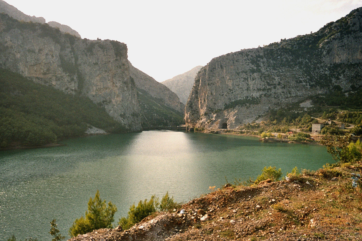
A wide, eye-level shot of a calm, turquoise lake nestled between two large, rocky, light-colored canyon walls, under a soft, hazy sky.
A wide view of Shkopet Lake, framed by the towering limestone cliffs within Lake Ulza Nature Park.

Lake Ulza Nature Park history and protected-area timeline

Lake Ulza Nature Park was established in 2013, formalizing protection for an area shaped by the reservoirs of the Mat River basin and the surrounding hills. Its creation reflected Albania's growing effort to recognize the ecological importance of this central inland landscape, including the forests, rocky habitats, and freshwater environments that frame Lakes Ulza and Shkopet.

In January 2022, the park underwent an administrative upgrade when it was approved for a change in status from a municipal natural park to a natural park under IUCN Category IV. This reclassification strengthened its protected status, aligning the area more closely with international conservation standards for habitat and species management.

Alongside its conservation profile, the park has also been promoted as a regional point of cultural and economic interest. Local events, including Saint Mark celebrations, have been used to showcase the area's natural and traditional values, and efforts have been made to support traditional local produce and agricultural products associated with the park's territory.

Lake Ulza Nature Park landscape and geographic character

The landscape of Lake Ulza Nature Park is built around water and the landforms that enclose it. Two reservoirs, Lake Ulza and Lake Shkopet, lie within the park's boundaries, set along the course of the Mat River in central Albania. They are flanked by a ring of mountains and hills, creating a valley scene in which still water, flowing river, and rising terrain alternate across a relatively short distance.

The terrain is characterized by what geologists call a polycene-quaternary relief zone, shaped over long stretches by river action and erosion. Sedimentary soils formed on gabbroic rocks dominate the lower ground, while the surrounding hills expose rocky outcrops typical of inland Albania. The dense hydrographic network of the area, anchored by the Mat River, ties together the lakes, streams, and slopes into one connected drainage landscape.

The elevation gradient within the park is modest but meaningful. Near the lakes, the land flattens toward the river corridor; moving outward, slopes rise into hills and mountains that frame the water bodies. This layered relief, from water surface to forested mid-slope to rocky uplands, gives the park its visual rhythm and supports a wide variety of habitats across a compact area.
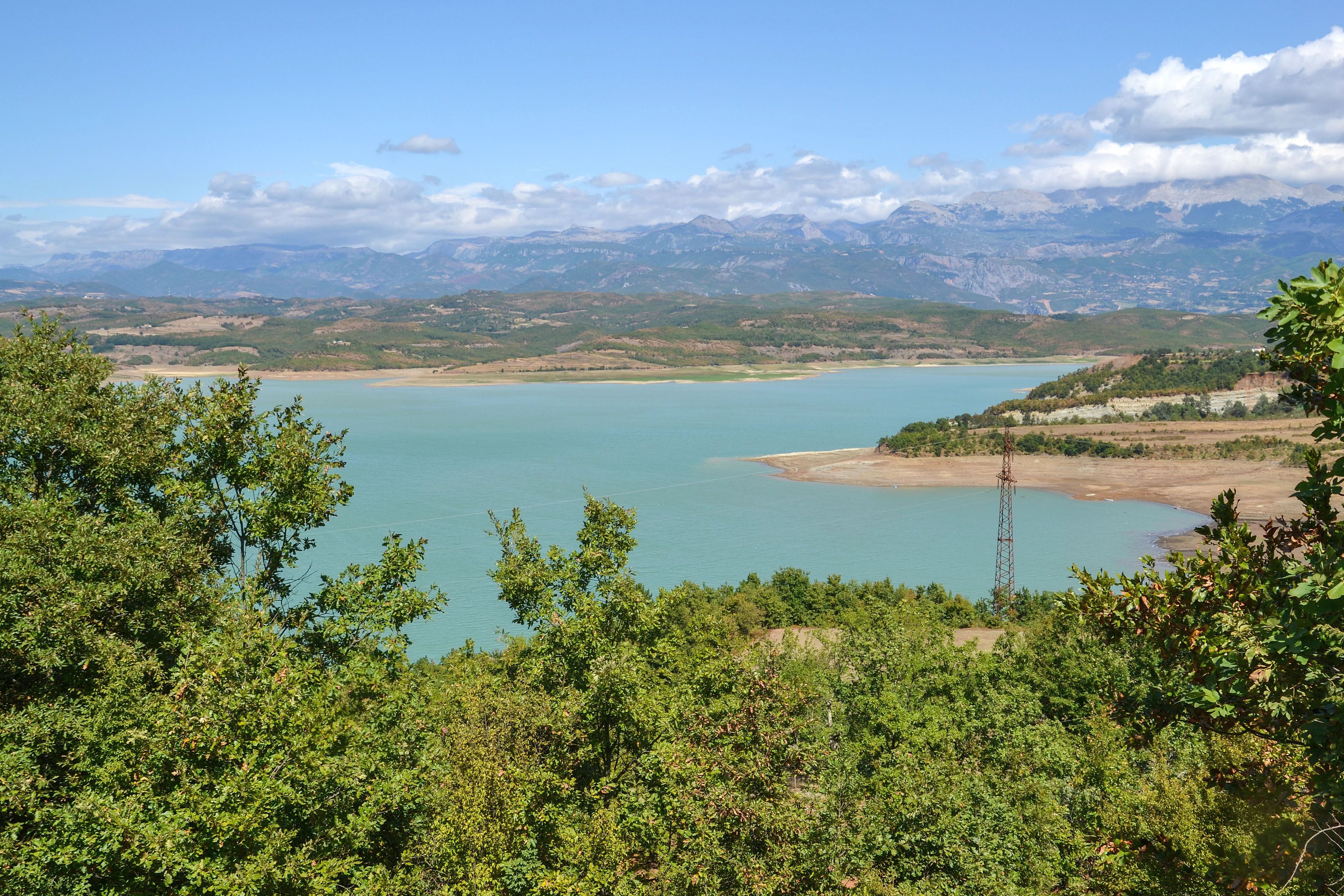
A wide shot overlooking the turquoise water of Lake Ulza, with dense green trees in the foreground, rolling hills in the midground, and distant mountains under a blue sky with clouds.
A scenic view over Lake Ulza, showcasing the turquoise water, surrounding forests, and mountainous backdrop of Lake Ulza Nature Park, Albania.

Lake Ulza Nature Park ecosystems, habitats, and plant life

Ecologically, Lake Ulza Nature Park is defined by the meeting of Mediterranean and inland Albanian habitats. The climate and geographic position of the area allow multiple forest types to coexist, and the presence of two lakes within the protected perimeter adds a strong freshwater element to the region's biodiversity.

The forests covering the park's slopes include black oak formations, thermophilic oak forests suited to warmer exposure, and mountainous to sub-alpine oak woodlands found on cooler or higher terrain. These forest types often blend into one another across the surrounding hills, creating a richer habitat mosaic than a single woodland type might suggest.

Beyond the forests, the park contains dry rocky habitats where stony ground and Mediterranean exposure produce specialized plant and animal communities. The combination of oak woodlands, rocky uplands, lake margins, and the Mat River corridor gives the park a layered ecological profile, recognized as nationally and internationally important for its range and for the flora and fauna it supports.

Lake Ulza Nature Park wildlife and species highlights

The wildlife value of Lake Ulza Nature Park is rooted in the variety of habitats it protects, rather than in any single high-profile species. The mixture of lake environments, river channels, oak forests, and rocky terrain creates conditions for diverse animal communities across a relatively contained area in central Albania.

The lakes of Ulza and Shkopet, alongside the Mat River, form freshwater habitats that support fish, aquatic invertebrates, waterbirds, and species that depend on shoreline vegetation. The surrounding oak forests, ranging from thermophilic to mountainous forms, provide habitat for forest-dwelling birds, mammals, and invertebrates typical of Albanian woodland. Rocky and exposed habitats add further ecological niches beyond the forested zones.

The park's official recognition of national and international importance for its flora and fauna reflects the role of this habitat diversity. Rather than being defined by a single animal population, Lake Ulza Nature Park functions as a regional biodiversity reservoir where the variety of habitats itself drives wildlife richness across the central Albanian landscape.

Lake Ulza Nature Park conservation status and protection priorities

Lake Ulza Nature Park represents a deliberate effort to formalize environmental protection around a landscape that combines natural ecosystems with engineered water infrastructure. Established in 2013 and reclassified in 2022 under IUCN Category IV, the park sits within the international system of habitat and species management areas, a category oriented toward maintaining healthy ecosystems alongside human use of the land.

The conservation significance of the park rests on its biodiversity-rich mix of Mediterranean oak forests, rocky habitats, lake ecosystems, and river environments. Protecting these habitats in a single connected unit helps preserve the ecological interactions between forest, water, and terrain that would be more vulnerable if managed separately.

Its reclassification from a municipal to a natural park in 2022 strengthened the park's protected standing and brought it closer to international standards for regional conservation. The park's profile also reflects a broader Albanian effort to extend protected-area coverage beyond remote mountain reserves into inhabited valley landscapes where ecological value and rural activity intersect.

Lake Ulza Nature Park cultural meaning and human context

Lake Ulza Nature Park has been promoted as a landscape where natural and cultural values meet in the central Albanian interior. Local government and environmental organizations have used cultural events, including Saint Mark celebrations, to draw attention to the park's identity and to encourage both visitors and residents to engage with the area's heritage.

The park's territory has also been linked to traditional local produce and agricultural products, with efforts aimed at supporting rural livelihoods associated with its surrounding communities. These initiatives tie the protected area to the everyday life of nearby settlements, including the towns along the Mat River valley such as Ulëz and Burrel, where the relationship between land, water, and human settlement has long shaped local identity.

Top sights and standout views in Lake Ulza Nature Park

The twin reservoirs of Ulza and Shkopet, set within the Mat River valley, give the park its central identity. Surrounding oak forests, rocky habitats, and river environments extend the protected value beyond the shorelines.

Its 2022 reclassification as an IUCN Category IV natural park reflects Albania's effort to recognize and safeguard inland habitat mosaics where water systems, woodland, and rocky terrain converge in a single regional setting.

Best time to visit Lake Ulza Nature Park

Lake Ulza Nature Park sits within a Mediterranean climate zone, so seasonal variation strongly shapes the experience of the landscape. Spring and early summer are typically the most attractive periods for visiting, when oak woodlands and riverside vegetation are active, water levels in the Mat River system are supported by seasonal rainfall, and the countryside around Burrel and Ulëz is at its greenest.

Autumn brings a quieter, drier character to the park, with stable lake surfaces and warm-toned forest cover along the hills. Summer can be hot, particularly in the lower valley sections, though it remains a popular season for visitors interested in the reservoirs themselves. Winter is generally mild for the lowland parts of the park but can bring colder conditions to the surrounding hills.
Monthly climate preview

Long-term representative temperature and precipitation averages recorded at benchmark coordinates

Lake Ulza Nature Park Climate Normals and Monthly Weather Patterns

Lake Ulza Nature Park maintains measured monthly temperature and precipitation rhythms reflecting historical climate normals from representative coordinates. Reviewing the complete twelve-month record clarifies temperature ranges and precipitation rates across the protected landscape.
Annual mean12 °C
2 °C24 °C
Jan
Feb
Mar
Apr10°
May15°
Jun20°
Jul23°
Aug24°
Sep18°
Oct13°
Nov
Dec
Warmest month
August

23.6 °C

Coolest month
January

1.9 °C

Wettest month
November

3.8 mm/day

Driest month
August

1 mm/day

Park location guide

Geography guide, regional context, and park location map for Lake Ulza Nature Park

Lake Ulza Nature Park park geography, regions, and map view in Albania

Understand where Lake Ulza Nature Park sits in Albania through a broader geographic reading of the surrounding landscape, nearby location context, and its mapped position within the national park landscape.

How Lake Ulza Nature Park fits into Albania

Albania is a unitary parliamentary republic in Southeast Europe, situated on the Balkan Peninsula along the Adriatic and Ionian coastal regions. With a population of approximately 2.4 million people, it borders Montenegro, Kosovo, North Macedonia, and Greece. The country features varied landscapes ranging from the Albanian Alps to fertile coastal plains, with Tirana as its capital and largest city.

Wider geography shaping Lake Ulza Nature Park in Albania

Albania occupies the western part of the Balkan Peninsula in Southeast Europe. The country features a varied terrain with rugged mountain ranges including the Albanian Alps (Accursed Mountains), Korab, Skanderbeg Mountains, Pindus, and Ceraunian Mountains. Fertile lowland plains extend along the Adriatic and Ionian coastal regions. The country borders Montenegro to the northwest, Kosovo to the northeast, North Macedonia to the east, and Greece to the south.

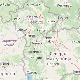
Map view of Lake Ulza Nature Park

Use this park location map to pinpoint Lake Ulza Nature Park in Albania, understand its exact geographic position, and read its mapped placement within the surrounding landscape more clearly.

Pigeon | © OpenStreetMap contributors

Location context for Lake Ulza Nature Park

Dibër County

Visualizing the twin reservoirs, oak woodlands, and rocky terrain of central Albania

Lake Ulza Nature Park Photos and Landscape Scenery

Visual records capture the twin reservoirs, dense oak woodlands, and rocky hill habitats defining the terrain of Lake Ulza Nature Park. Photographic documentation reveals the protected area character and water valley scenery found across inland Albania.

A wide, eye-level shot of a calm, turquoise lake nestled between two large, rocky, light-colored canyon walls, under a soft, hazy sky.

A wide-angle landscape shot of a turquoise river winding through a valley flanked by dense green forests and rugged mountains under a blue sky with white clouds.

A wide shot overlooking the turquoise water of Lake Ulza, with dense green trees in the foreground, rolling hills in the midground, and distant mountains under a blue sky with clouds.

Park atlas

Compare surrounding regional nature parks and connected river valley landscapes in central Albania

Explore Protected Areas and Parks Near Lake Ulza Nature Park

Browse other protected areas and regional nature parks situated near Lake Ulza Nature Park in central Albania. Comparing these adjacent river valleys and reservoir landscapes reveals broader patterns in regional conservation geography.
Nature reserveAlbania
About 17 km away#1 closest

South

Shtamë Pass Nature Park: Geographic Overview and Protected Mountain Landscape Map

Highland pine forests and freshwater corridors in Albania

Shtamë Pass Nature Park sits within the central Albanian mountains, providing a critical ecological link between coastal-inland gateway regions. The area protects a complex mosaic of alpine terrain, including clear mountain lakes, cold freshwater springs, and dense black pine forests that shelter brown bears and wolves. This protected zone offers a comprehensive view of regional highland geography and topography through its distinct mountain pass corridor.

Area
68.64 km²
Established
1996
IUCN
IV
A minimalist watercolor painting depicting a soft-focus landscape with green marshes, pale yellow flats, and light pink rolling hills in the background.
Nature reserveLezhë County
About 24 km away#2 closest

West

Kunë-Vain-Talë-Patok-Fushëkuqe-Ishëm Nature Park: Mapped Geography and Coastal Wetlands

Protected lagoon and forest landscapes in Lezhë County, Albania

Examine the protected territory of Kunë-Vain-Talë-Patok-Fushëkuqe-Ishëm Nature Park, defined by its dynamic lagoon systems, alluvial forests, and coastal dunes along the Adriatic shore. This area provides deep insight into deltaic hydrology and the preservation of Mediterranean woodland habitats within a regional geographic context.

Area
43.93 km²
Established
2010
IUCN
IV
Relief
Lowland
Watercolor illustration of rolling green hills and distant mountains under a soft sky
National parkDibër County
About 33 km away#3 closest

Northeast

Lurë-Dejë Mountain National Park: Mapped Protected Landscape and Glacial Lake Geography

Dibër County's alpine protected area with unique glacial lakes.

Delve into the detailed geographic context and mapped protected area of Lurë-Dejë Mountain National Park, an essential natural landscape in Albania's Dibër County. This park is renowned for its rare chain of twelve glacial lakes, situated at high elevations amidst dramatic alpine terrain. Its protected status ensures the preservation of significant old-growth forest ecosystems, including the critically endangered Balkan pine, contributing to its recognition as an Important Bird and Plant Area. Explore the park's distinctive terrain, from its soaring mountain peaks to its unique alpine meadows, all within a comprehensive geographic atlas framework.

Area
202.42 km²
Established
1966
IUCN
II
Relief
Mountain
National parkAlbania
About 35 km away#4 closest

South

Dajti Mountain National Park: Albania's Accessible Protected Mountain Landscape for Geographic Discovery

Explore the mapped terrain and diverse ecosystems of this significant national park.

Dajti Mountain National Park is a prime example of a protected mountain landscape central to Albania's geography. Situated near Tirana, its rugged karst topography, steep limestone ridges, and varied elevation create distinct ecological zones. This atlas-focused entry details the park's terrain, notable geological features like Pellumbas Cave, and its role as a significant protected area offering rich mapped landscape context.

Area
293.84 km²
Established
1966
IUCN
II
Relief
Mountain
An abstract watercolor painting showing a horizontal landscape with grassy foreground and distant rolling hills in soft green, yellow, and purple tones.
Nature reserveDibër County
About 36 km away#5 closest

South

Mali me Gropa-Bizë-Martanesh Nature Park: Karst Plateau and Mountain Geography in Central Albania

A diverse nature reserve in the heart of the Albanian highlands

This protected area features a unique mosaic of karst landscapes, including the distinctive Mali me Gropa plateau, alongside deep canyons and glacial features. It provides essential habitat for large carnivores and represents a vital ecological link within the mountain terrain of central Albania, offering a structured look at the region's vertical landscape zonation and natural monuments.

Area
252.66 km²
Established
2007
IUCN
IV
Relief
Mountain
A horizontal watercolor painting of a serene river landscape with green trees on both banks and small boats floating on the water at sunset.
Protected landscapeShkodër County
About 45 km away#6 closest

Northwest

Buna River-Velipojë Protected Landscape: Albania Coastal and Wetland Geography

Mapped protected landscape in Shkodër County

The Buna River-Velipojë Protected Landscape encompasses the crucial junction of riverine systems and the Adriatic Sea. This protected area features a mosaic of marshes, lagoons, and alluvial forests that form a significant migratory corridor in northwestern Albania.

Area
230.27 km²
Established
2005
IUCN
V
Relief
Lowland
National parkNorth Macedonia
About 54 km away#7 closest

East

Mavrovo National Park: North Macedonia's Extensive Protected Alpine Terrain and Wildlife

Mapped geography of Alpine peaks, gorges, and unique endemic species.

Mavrovo National Park, North Macedonia's largest protected area, offers a deep dive into a complex Alpine geography. Dominated by the Šar, Korab, and Bistra mountain systems, the park features towering peaks and the dramatic Radika River gorge. This protected landscape is globally significant for its role in conserving the rare Balkan lynx and harbors endemic tertiary relic plant species like Macedonian pine. Explore the mapped boundaries, glacial lakes, and distinct terrain that define this vital conservation area.

Area
730.88 km²
Established
1949
IUCN
II
Relief
Mountain
A watercolor painting showing a panoramic view of green rolling hills and a body of water under a soft, light sky.
Nature reserveShkodër District
About 54 km away#8 closest

Northwest

Lake Shkodër Nature Reserve: Mapping Protected Wetland and Riverine Geography in Albania

A critical Balkan freshwater protected area.

The Lake Shkodër Nature Reserve serves as a foundational protected landscape in northern Albania, encompassing the extensive shoreline and riverine floodplains of Lake Skadar. This geographic entity showcases a transition from fertile lowlands to mountainous ridges, offering a detailed look at how hydrologic processes and alpine proximity define Balkan wetland habitats.

Area
265.35 km²
Established
2005
IUCN
IV
Relief
Lowland

Common questions about visiting, size, designation, and location context for Lake Ulza Nature Park

Lake Ulza Nature Park FAQs for park facts, access, geography, and protected area context

Find quick answers about Lake Ulza Nature Park, including protected-area facts, park geography, trail and visitor context, and how the park fits into its surrounding country and regional landscape.
MoriAtlas Explorer

Continue Your Protected Areas Search Across the Global Atlas

Deepen your exploration by continuing the structured search for national parks and protected areas worldwide. Utilize the comprehensive filtering capabilities to compare different conservation landscapes and refine your understanding of global park geography. Discover more about the distribution and characteristics of protected natural areas.

Global natural geography