
Why Landschaftsschutzgebiet Berchumer Heide, Reher Heide stands out
The landscape protection area is especially known for the striking ecological transition it preserves between the heavily forested Wannebach valley system and the open agricultural uplands of the Berchumer and Reher Heide. It functions as a protective buffer around two nature reserves in the Wannebach valley, the Unteres Wannebachtal and Oberes Wannebachtal, and supports near-natural forest habitat with steep, deeply incised stream-cut valleys and small woodland pools known locally as Siepen and Tümpel. The protected area is also notable for integrating ecological value with cultural heritage, featuring the historic Reher Galgen execution site as a designated cultural monument, and for its proximity to the 229-meter Rehberg hill, a recognizable local elevation within the Hagen urban region.
Landschaftsschutzgebiet Berchumer Heide, Reher Heide history and protected-area timeline
The protected status of Landschaftsschutzgebiet Berchumer Heide, Reher Heide was formally established in 1994, when the city council of Hagen adopted the city's overarching landscape plan. By being incorporated into this plan, the area received the standard German Landschaftsschutzgebiet designation tied explicitly to the purposes laid out in that framework, including the protection of natural habitats, the safeguarding of scenic qualities, and the provision of an area for quiet, near-nature recreation.
The 1994 designation occurred against the backdrop of regional land-use planning that interlocked multiple protection regimes. The area was aligned at the same time with the broader Gebietsentwicklungsplan, within which portions south of Berchum village were identified as potential residential settlement areas. As a result, the landscape plan provides that, if the relevant land-use plan is changed to permit residential development, the landscape protection status automatically expires for the affected parcels, an unusual built-in mechanism that ties ecological protection directly to land-use planning decisions.
Beyond its formal administrative history, the landscape carries longer and deeper historical traces. Along the Schälker Landstraße, within the protected area, lies the historic Reher Galgen, a documented execution site recognized as a cultural monument. The site remains visible in the terrain as a small earthen mound, a tangible reminder that the contemporary agricultural and forested landscape overlays older layers of regional use and juridical history that long predate modern conservation frameworks.
Landschaftsschutzgebiet Berchumer Heide, Reher Heide landscape and geographic character
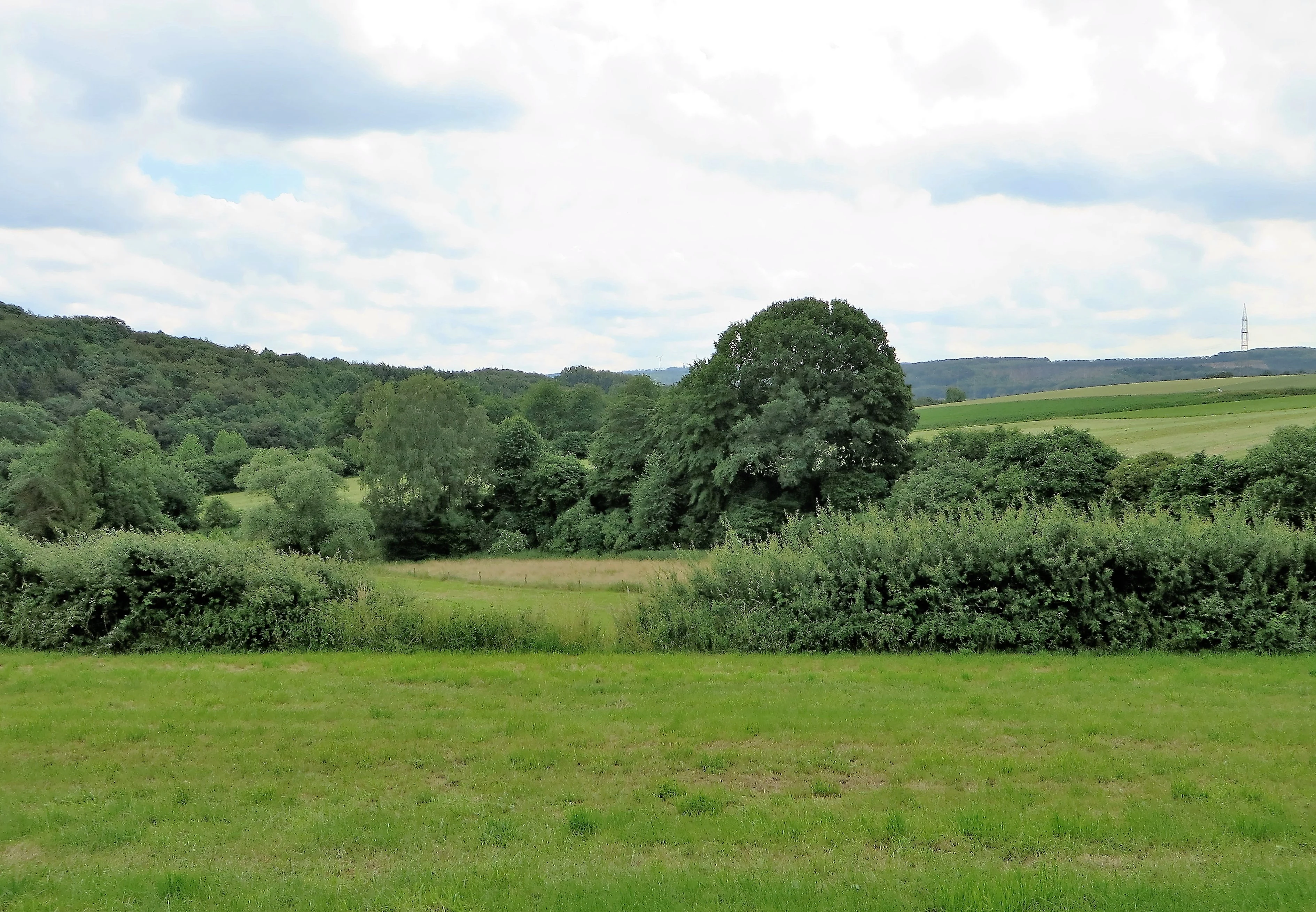
The landscape of the protected area is shaped above all by the contrast between two clearly differentiated zones. The southern reaches consist largely of closed canopy forest, where mature woodlands blanket the slopes around the Wannebach valley. The forest is not a uniform mass: it is deeply indented by the small tributaries of the Wannebach, which have cut narrow, steep, often shaded ravines into the hillside. These characteristic Siepen, together with small forest pools and seepage hollows, introduce a strong micro-topographic variability into what might otherwise be read as a continuous forest block.
The northern part of the protected area opens up sharply. Here, the terrain flattens and broadens into agricultural land, with fields and meadows forming the dominant land cover. A golf course is also present in this northern zone, embedded in the otherwise agricultural matrix. The transition between the dense forest of the south and the open fields of the north is not a single abrupt line but a graduated shift that includes mixed forest edges, small groves, and field margins.
Anchoring the topography is the Rehberg, which rises to 229 meters within the protected area, providing one of the higher local vantage points along the Hagen edge of the Märkischer Kreis border. The Wannebach valley system forms a low-lying central axis, holding the most ecologically distinctive parts of the area and connecting this protected landscape to neighboring nature reserves and protected areas that extend the green corridor across municipal boundaries.
Landschaftsschutzgebiet Berchumer Heide, Reher Heide ecosystems, habitats, and plant life
The protection area protects a particularly layered mosaic of habitats across a relatively compact footprint. In the southern and central portions, the Wannebach valley and its small tributary ravines support near-natural deciduous and mixed forest communities. The combination of steep slopes, persistent moisture, and accumulated dead wood in these forest sections creates conditions that are difficult to replicate in more intensively managed woods in the region. Numerous plant and animal species associated with these near-natural forest habitats are recorded in the area, with particularly sensitive occurrences cited as justification for additional protection by means of the geschützter Landschaftsbestandteil designation applied to the most valuable Siepen and Tümpel.
In the northern portions of the protected area, the habitat tone shifts to semi-open cultural landscape. Arable fields, meadows, and grazed grassland occupy the rolling terrain, with hedgerows, field margins, and small green corridors providing connectivity to the more wooded sections to the south. This agricultural zone supports a different ecological community, including field-breeding birds, small mammals, and pollinators dependent on the edge habitats between cropland, grassland, and the forest fringe.
Together, these habitats form a working ecological gradient from intensively used agricultural land at the northern edge to canalised forest with intact forest pools and stream-cut ravines in the center, and finally to the protected core of the Wannebach valley nature reserves. The landscape plan treats this gradient as itself a protected feature, valuing the interweaving of forest and grassland as much as the individual habitats themselves.
Landschaftsschutzgebiet Berchumer Heide, Reher Heide wildlife and species highlights
The area is documented as supporting a notable concentration of plant and animal species associated with structurally rich, near-natural forest and forest-margin habitats. While the source does not provide a detailed species inventory, the protection framework built around the area is explicitly justified by the presence of endangered species tied to the Wannebach valley and its tributary ravines.
The forest pools, seepage zones, and damp leaf-litter environments within the steep Siepen create habitat for amphibians and a range of invertebrates tied to small-scale persistent water bodies. The closed forest canopy and structurally varied dead wood support insect and fungi communities typical of older, less disturbed mixed deciduous forest. Along the margins where forest meets the agricultural zone, the habitat mosaic supports typical edge species including woodland birds, songbirds using field margins, and small mammals that use the ecotonal transitions.
The presence of a golf course and agricultural land in the northern portion introduces a different set of wildlife pressures and opportunities; the surrounding forest and valley corridors nonetheless provide substantial refugia. In this way the protected area functions less as a single habitat type and more as a connected wildlife landscape, where the variety of land uses combined with the protective buffer around the nature reserves creates conditions for a richer fauna than the surrounding region typically supports.
Landschaftsschutzgebiet Berchumer Heide, Reher Heide conservation status and protection priorities
The protection framework applied to this landscape rests on a deliberate layering of complementary designations. The 1994 landscape plan of the city of Hagen established the overarching Landschaftsschutzgebiet status, defined in the plan text by three explicit purposes: maintenance and restoration of the functional capacity of the natural environment, securing near-natural habitats, preservation of the diversity, character, and beauty of the landscape, and the protection of an area suitable for quiet recreation close to nature, especially for experiencing near-natural habitats.
Within this broader protection envelope, the Wannebach valley is given additional protection through the two embedded nature reserves, the Unteres Wannebachtal and the Oberes Wannebachtal. The most ecologically exceptional small features, including especially valuable Siepen and Tümpel, are further singled out as geschützte Landschaftsbestandteile. This layered design is mirrored by the protected landscape continuing across the municipal border into adjacent designations in the Märkischer Kreis and the Kreis Unna, where the Wannebach valley and its forelands are protected as part of the Landschaftsschutzgebiet Iserlohn Typ A or as part of the Naturschutzgebiet Wannebachtal.
The Hagen landscape plan also ties the conservation regime to spatial planning. A specific clause provides that, should Hagen's land-use plan be revised to designate parts of the protected area south of Berchum as residential settlement, the landscape protection designation will lapse for those parcels alone. This makes the conservation status of this protected area directly and visibly dependent on the city's planning choices, a distinctive feature of how protection is integrated with urban growth management in Hagen.
Landschaftsschutzgebiet Berchumer Heide, Reher Heide cultural meaning and human context
Although the area's primary character is shaped by its forests, fields, and valleys, the cultural layers of the landscape remain a real and protected part of the protected area's identity. The most prominent cultural element documented in the protected area itself is the Reher Galgen, a historical execution site located near the Schälker Landstraße. Although modest in scale and now visible as a small earthen mound, the site is recognized as a cultural monument and is marked in the field to preserve its historical meaning within the landscape.
The agricultural land in the northern portion of the protected area also carries an underlying rural cultural identity. The pattern of fields, meadows, and grazing land reflects the long-standing use of the Wannebacher Hochflächen as working countryside on the edge of the city of Hagen. The presence of the Reichsgolf course in this northern zone additionally signals the evolving recreational culture of the area, blending older agricultural uses with more contemporary forms of landscape leisure. Together, these cultural traces give the protected area a layered identity that extends beyond its ecological function.
Top sights and standout views in Landschaftsschutzgebiet Berchumer Heide, Reher Heide
The protected area offers a compact but unusually layered set of ecological and cultural features within the urban district of Hagen. The seamless transition from open agricultural land in the north to closed, near-natural forest in the south is a defining visual quality, and is treated in the landscape plan as a protected characteristic in its own right. At the same time, the deeply incised Siepen, the wooded pools of the Wannebach valley, and the surrounding nature reserves concentrate some of the most ecologically valuable habitats within the city limits into a single landscape mosaic.
What sets the area apart from many other city-region landscape protection areas is the combination of strict natural protection at the valley core with a broader landscape protection framework that also embraces hedge-rich agricultural land, historical sites such as the Reher Galgen, and an accessible recreational landscape. The cross-boundary continuity of protection into the Märkischer Kreis and Kreis Unna further extends the conservation value of the area, making it a node in a wider regional ecological network rather than an isolated city-edge reserve.
Best time to visit Landschaftsschutzgebiet Berchumer Heide, Reher Heide
The landscape is shaped by the seasonal rhythm of deciduous forest and agricultural land in the West German low mountain region, with the Wannebach valley and its forest features remaining largely accessible year-round. Spring brings the unfolding of the forest canopy and the fresh green of grasslands and hedgerows; in late spring and early summer, the meadows in the northern portion of the protected area typically reach their highest visual diversity, and woodland bird and amphibian activity is most evident around the Siepen and Tümpel in the south.
Late summer and autumn give the forest a more enclosed, visually warmer character, while the open fields of the north take on the tonal shifts of harvest and grazing cycles. Winter opens up broader sight lines across the agricultural portions of the area and emphasizes the structural contrast between the open land and the dark mass of the Wannebach forest. Because the area is embedded within the framework of Hagen's landscape plan and supports quiet recreation, visits focused on walking and observing near-natural habitats remain meaningful across all seasons rather than being concentrated in a single window.