
Mori Atlas logo
Protected landscapeLandschaftsschutzgebiet Brandenburger Osthavelniederung

A study of alluvial floodplain terrain, glacial moraine outliers, and Havel river hydraulics.

Landschaftsschutzgebiet Brandenburger Osthavelniederung: Mapped Geography and Protected Landscape Boundaries

Landschaftsschutzgebiet Brandenburger Osthavelniederung represents a distinct cultural and natural corridor within Brandenburg, defined by its remarkably flat alluvial plain and abrupt glacial elevations. This protected area showcases the complex interplay between the Havel River, its interconnected lake systems, and human-managed water infrastructure. The landscape features a striking contrast between low-lying, drained agricultural fields and the pine-clad heights of the Götzer Berg and Eichelberg.

landscape protection areahavel floodplainalluvial plainglacial morainesriver landscapelowland scenery
A graphic illustration showing a winding river flowing through a lush mountain valley with a waterfall on the right, surrounded by pine forests and cliffs under a soft sunset sky.

Landschaftsschutzgebiet Brandenburger Osthavelniederung

Protected landscape

Park overview

Structured park overview, official facts, and landscape profile for Brandenburger Osthavelniederung Landscape Protection Area

Brandenburger Osthavelniederung Landscape Protection Area park facts, protected area profile, and essential visitor context

Review the core facts for Brandenburger Osthavelniederung Landscape Protection Area, including designation, size, terrain, visitor scale, habitats, and operating context in one park-focused overview.

About Brandenburger Osthavelniederung Landscape Protection Area

The Brandenburger Osthavelniederung is a protected cultural landscape set in the lower valley of the Havel River in western Brandenburg. It forms a transitional zone between the city of Brandenburg an der Havel to the west, the agricultural land around Groß Kreutz (Havel) and Werder (Havel) to its east, and the Havel lake district further downstream toward Potsdam. By legal designation it is a Landschaftsschutzgebiet, a category of German protected area focused on preserving the character of a region rather than on strict nature reserve rules.

At its core, the reserve follows the broad, low floodplain of the Havel as it meanders and widens into lakes west of Potsdam. The river itself and lakes such as the Götzer See and Jeseriger See are central to the area's identity, joined by the Emster Kanal, which links parts of the local water system. Because the Havel's water level is normally higher than the surrounding land, the plain is enclosed by dikes and drained by pumping stations, giving the landscape its characteristically flat, regulated appearance.

The reserve is not solely a wetland landscape. Low ground moraine plateaus and pushed end moraines rise above the floodplain in the eastern part of the area, most prominently at the Götzer Berg (108 meters) and the Eichelberg near Deetz (89 meters). These dry outcrops carry pine forest on their summits, while their lower slopes and gentler ground moraine areas host orchards and farmland. The combination of alluvial plain, glacial ridges, cultivated fields, orchards, pine forest, and a network of lakes, canals, and dikes defines the distinctive protected scenery of the Brandenburger Osthavelniederung.

Quick facts and research context for Brandenburger Osthavelniederung Landscape Protection Area

The Brandenburger Osthavelniederung was established as a landscape protection area (Landschaftsschutzgebiet) on 21 July 1998 under a dedicated protection ordinance. Its total extent is roughly 9,380 hectares, and it lies in the west of Brandenburg, west of Potsdam, and partly within the city limits of Brandenburg an der Havel. The northern part of the municipality of Groß Kreutz (Havel) and parts of the Werder (Havel) district of Derwitz fall within its boundaries, all in the Potsdam-Mittelmark area. The protected landscape is fully situated in the Brandenburg-Potsdamer Havelgebiet natural region, a subunit of the central Brandenburg plateaus and lowlands.

Protection and recognition

Documented terrestrial conservation measures and recognition records

Protection Status and Designated Scope for Landschaftsschutzgebiet Brandenburger Osthavelniederung

Landschaftsschutzgebiet Brandenburger Osthavelniederung maintains a documented terrestrial protection scope within its regional landscape. Structured records outline the official conservation status and administrative designation parameters associated with the protected area.

Protection details

Protection scope
Terrestrial
Transboundary protection
No
Park context

Deeper park guide and search-rich context for Brandenburger Osthavelniederung Landscape Protection Area

Brandenburger Osthavelniederung Landscape Protection Area history, landscape, wildlife, and travel context

Explore Brandenburger Osthavelniederung Landscape Protection Area through its history, landscape character, ecosystems, wildlife, conservation priorities, cultural context, and seasonal travel timing in a structured park guide built for atlas discovery and search intent.

Why Brandenburger Osthavelniederung Landscape Protection Area stands out

The area is best known for the remarkably flat Havel floodplain that lies just above the river and its backwater lakes. This plain, only about 30 meters above sea level, is the result of centuries of river flooding and artificial water management back to medieval times, with the Havel being dammed at Brandenburg an der Havel since the 13th century. The Götzer Berg and the Eichelberg rise abruptly from this lowland as isolated, pine-clad moraine outliers, creating a striking contrast between marshy farmland and forested glacial hillocks. The reserve is also recognized for its tightly engineered water landscape, where dikes, pumping stations, and the Emster Kanal keep the low-lying fields dry even though the river itself often sits higher than the surrounding land. Within this setting, a mosaic of drained arable fields, meadows, orchards on the dry ridges, and pine woodland on the moraine tops combines into a distinctive cultural landscape shaped by both glacial geology and centuries of river management.
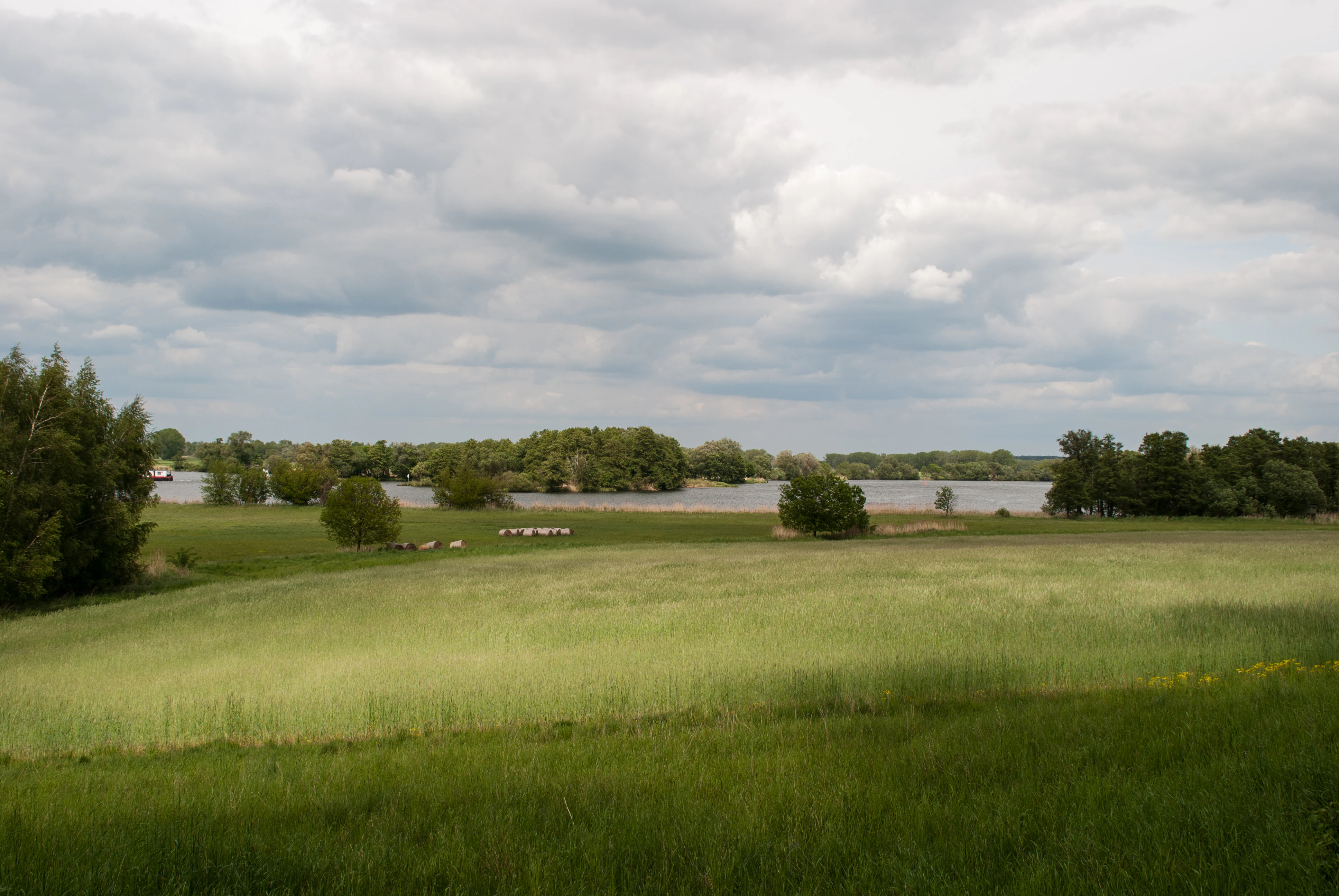
A wide view of a green meadow in the foreground leading to the Havel river surrounded by trees under a cloudy sky.
A view of the Havel river landscape within the Brandenburger Osthavelniederung.

Brandenburger Osthavelniederung Landscape Protection Area history and protected-area timeline

The current appearance of the Brandenburger Osthavelniederung reflects centuries of human influence on the Havel floodplain. The river has been dammed at Brandenburg an der Havel since the 13th century, and that long-standing Havelstau effectively raised water levels across the surrounding lowland. In response, the region developed a managed landscape of dikes, canals, and pumping works that allowed farming to continue on land that would otherwise have been regularly inundated.

The area received formal recognition as a landscape protection area on 21 July 1998, when the 'Verordnung über das Landschaftsschutzgebiet Brandenburger Osthavelniederung' was enacted. This ordinance established the current boundaries, covering roughly 9,380 hectares across parts of Groß Kreutz (Havel), Werder (Havel), and the independent city of Brandenburg an der Havel. Beyond protecting the visual and cultural qualities of the Havel lowland, the designation also positions the area within a larger chain of protected landscapes that follow the Havel westward and northward, including the Westhavelland landscape protection area and Naturpark Westhavelland.

Brandenburger Osthavelniederung Landscape Protection Area landscape and geographic character

The defining landform of the reserve is an extremely flat Schwemmlandebene, an alluvial floodplain lying between approximately 29.5 and 31 meters above sea level. This plain was shaped over centuries by repeated flooding following the damming of the Havel at Brandenburg an der Havel in the Middle Ages, which lifted the river's base level and backed water up into the lower reaches of the valley. Today the plain appears as an almost level expanse of drained farmland, punctuated by drainage features rather than relief.

Breaking this flatness in the eastern part of the protected area are isolated low ridges of ground moraine, along with stacks of pushed end moraine that stand well above the surrounding plain. The Götzer Berg reaches 108 meters and the Eichelberg near Deetz rises to about 89 meters, both forming conspicuous landmarks above the Havel lowland. Between and around these moraine outliers lie the lakes and channels that mirror the broad, quiet character of the Havel itself, including the Götzer See and the Jeseriger See, while the Emster Kanal threads through the network of waterways. The combination of near-flat floodplain, steep but small glacial hills, and a dense water network gives the reserve a landscape of strong contrasts in miniature.

Brandenburger Osthavelniederung Landscape Protection Area ecosystems, habitats, and plant life

Ecologically, the Brandenburger Osthavelniederung is shaped by the interplay between water and land typical of the Havel lowlands. The flat floodplain carries drained meadows and arable fields rather than extensive natural wetland, reflecting long-standing agricultural use, while the watercourses, lakes, and canal features remain the principal ecological backbone of the area.

The moraine outcrops and their associated dry slopes introduce a very different habitat character. Pine woodland occupies the higher, sandy ground moraine and end moraine surfaces where soil conditions are too dry for farming, and orchards are widespread across the gentler ground moraine parts of the eastern portion of the reserve. Together the dry pine ridges, orchard slopes, moist meadows, and open waters create a mosaic of small habitat types across a relatively compact landscape.

As a landscape protection area rather than a nature reserve, the ecological emphasis falls on maintaining this mosaic of cultivated, forested, and aquatic habitats in balance, rather than on safeguarding a single rare ecosystem. The reserve connects ecologically with adjacent protected areas along the Havel, contributing to a broader corridor of lowland river and lake habitats in western Brandenburg.

Brandenburger Osthavelniederung Landscape Protection Area conservation status and protection priorities

The conservation purpose of the Brandenburger Osthavelniederung is to preserve the characteristic scenery of the Havel floodplain west of Potsdam, including its mix of drained farmland, dikes, canals, lakes, orchards, and glacial moraine outliers. As a Landschaftsschutzgebiet, its primary focus is on safeguarding the visual and cultural landscape, the traditional land uses that maintain it, and the natural elements such as watercourses and woodland that give it identity, rather than on tight restrictions like those in a nature reserve.

The reserve also plays a connecting role within a wider network of protected areas along the Havel. It borders the Potsdamer Havelseengebiet and Potsdamer Wald- und Havelseengebiet landscape protection area to the east, the Ketziner Bruchlandschaft to the northeast, and the Westhavelland landscape protection area to the north, much of which coincides with the Naturpark Westhavelland. Through this arrangement, the Brandenburger Osthavelniederung contributes to continuity of protected lowland river and lake habitats across western Brandenburg.

Brandenburger Osthavelniederung Landscape Protection Area cultural meaning and human context

The landscape expresses a long tradition of managing low-lying land along the Havel. Since the 13th century, the damming of the river at Brandenburg an der Havel has required dikes, controlled drainage, and pumping to keep farmland workable, and the visible infrastructure of dikes, drainage ditches, and pumping stations is as much part of the cultural landscape as the fields themselves.

Orchards on the moraine slopes and pine on the dry sandy ridges combine old agricultural land use with the natural character of glacial deposits. The presence of small towns and villages within the broader protected area, including parts of Groß Kreutz (Havel), Derwitz, and the outskirts of Brandenburg an der Havel, links this rural scenery to the long-standing settlement history of the Havel valley.

Top sights and standout views in Brandenburger Osthavelniederung Landscape Protection Area

A nearly level Havel floodplain kept dry by dikes and pumping stations, contrasted with isolated pine-clad moraine outliers such as the Götzer Berg and the Eichelberg.

A network of lakes and channels at the heart of the area, including the Havel itself, the Götzer See, the Jeseriger See, and the Emster Kanal, defining the visual and ecological character of the reserve.

Best time to visit Brandenburger Osthavelniederung Landscape Protection Area

The reserve's character changes with the seasons in ways typical of lowland river landscapes in Brandenburg. Spring and early summer bring fresh green meadows and active water management, when fields, orchards, and dikes are at their most vivid and water levels on the Havel can be relatively high. Late summer and autumn highlight the harvested farmland and the warm tones of the orchard slopes on the ground moraines, while the open, flat terrain offers wide views across the floodplain toward the moraine outliers in any season.

Winter can give a particularly clear impression of the area's flatness, when bare fields and low sun emphasize the contrast between the floodplain and the small but prominent forested hills such as the Götzer Berg. Visitors interested in water scenery may find late spring and summer especially rewarding, when lakes, canals, and the Havel itself are most active in the landscape.

Monthly climate preview

Long-term representative point measurements tracking monthly temperature and precipitation rhythms in Brandenburg

Climate Normals and Annual Temperature Range for Landschaftsschutzgebiet Brandenburger Osthavelniederung

Representative coordinate records show measured monthly temperature variations alongside sustained precipitation averages across twelve distinct observation cycles. Examining the complete climate profile provides deeper monthly context for historical temperature ranges and precipitation patterns.
Annual mean9 °C
0 °C20 °C
Jan
Feb
Mar
Apr
May14°
Jun18°
Jul20°
Aug20°
Sep15°
Oct
Nov
Dec
Warmest month
July

19.9 °C

Coolest month
January

-0.4 °C

Wettest month
July

2.4 mm/day

Driest month
April

1.1 mm/day

Park location guide

Geography guide, regional context, and park location map for Brandenburger Osthavelniederung Landscape Protection Area

Brandenburger Osthavelniederung Landscape Protection Area park geography, regions, and map view in Germany

Understand where Brandenburger Osthavelniederung Landscape Protection Area sits in Germany through a broader geographic reading of the surrounding landscape, nearby location context, and its mapped position within the national park landscape.

How Brandenburger Osthavelniederung Landscape Protection Area fits into Germany

Germany is a federal republic in Western and Central Europe with a population of over 83 million across sixteen constituent states. It is Europe's largest economy by nominal GDP and a major global exporter and importer. The capital is Berlin, and the country borders Denmark, Poland, Czech Republic, Austria, Switzerland, France, Luxembourg, Belgium, and the Netherlands.

Wider geography shaping Brandenburger Osthavelniederung Landscape Protection Area in Germany

Germany is located in Western and Central Europe, spanning 357,022 km². It borders Denmark to the north, Poland and the Czech Republic to the east, Austria and Switzerland to the south, and France, Luxembourg, Belgium, and the Netherlands to the west. The country has coastlines on the Baltic Sea and North Sea to the north, with the Alps located in the southern region.

Map view of Brandenburger Osthavelniederung Landscape Protection Area

Use this park location map to pinpoint Brandenburger Osthavelniederung Landscape Protection Area in Germany, understand its exact geographic position, and read its mapped placement within the surrounding landscape more clearly.

Pigeon | © OpenStreetMap contributors

Location context for Brandenburger Osthavelniederung Landscape Protection Area

Brandenburg

Visual exploration of alluvial floodplains, glacial moraines, and river habitats

Landschaftsschutzgebiet Brandenburger Osthavelniederung Photos and Scenery

Examine detailed photography showcasing the flat Havel floodplains, engineered waterways, and pine-clad glacial moraines of the protected area. Visual records provide clear reference material for understanding the distinct terrain, aquatic networks, and lowland scenery of the reserve.

A wide view of a green meadow in the foreground leading to the Havel river surrounded by trees under a cloudy sky.

Park atlas

Discover adjacent protected landscapes and regional river reserves in western Brandenburg.

Explore Parks Near Landschaftsschutzgebiet Brandenburger Osthavelniederung

Compare protected areas surrounding Landschaftsschutzgebiet Brandenburger Osthavelniederung to analyze similar river floodplains and glacial moraine formations. Evaluating these neighboring reserves reveals broader ecological patterns across the central German lowlands.
Nature reserveBrandenburg
About 7.4 km away#1 closest

East

Naturschutzgebiet Krielower See: Protected Nature Reserve and Glacial Wetland Geography

Located in Brandenburg, this reserve protects a complex, silted-up lake basin and wetland network.

Naturschutzgebiet Krielower See protects a distinct glacial landscape near the Havel river. This 155-hectare nature reserve preserves a network of alder carr, reed beds, and wet meadows, providing an essential refuge for diverse species within the broader Havelland natural region. Explore the mapped topography and conservation context of this integral Brandenburg wetland habitat.

Area
1.55 km²
Established
2004
Relief
Lowland
Climate
Temperate
A watercolor illustration showing a landscape with small clusters of trees and grassy ground under a soft, light-filled sky.
Nature reserveBrandenburg
About 12 km away#2 closest

South

Lehniner Mittelheide und Quellgebiet der Emster: Nature Reserve and Protected Landscape Atlas

Mapping Brandenburg inland heath and spring valley terrain

Examine the geographic layout of Lehniner Mittelheide und Quellgebiet der Emster, a nature reserve in the Brandenburg district of Potsdam-Mittelmark. This protected area connects dry sandy heathland with the aquatic corridors of the Emster headwaters and Mühlenteich pond, offering a clear example of glacial lowland landscape integration.

Area
6.4 km²
Established
1996
IUCN
IV
Relief
Lowland
A soft watercolor illustration showing rolling green hills, a small stream winding through the foreground, and distant purple-toned peaks against a white background.
Nature reserveBrandenburg
About 14 km away#3 closest

Southeast

Glindower Alpen: Protected Nature Reserve and Clay Mining Geography in Brandenburg

A striking post-industrial landscape and nature reserve

Glindower Alpen is a 120-hectare nature reserve near Werder, Germany, characterized by an atypical terrain of deep ravines and ridges resulting from historical clay mining. This protected area stands out as an island of mixed deciduous forests and dry grasslands amidst the broader flat geography of the Brandenburg region.

Area
1.19 km²
Established
1995
Relief
Upland
Climate
Temperate
A soft, artistic watercolor painting of a river landscape with trees, grassy banks, and rolling hills in the background.
Nature reserveBrandenburg
About 15 km away#4 closest

Northeast

Falkenrehder Wublitz Nature Reserve: Brandenburg Wetland Geography and Protected Landscape Atlas

A mapped riparian wetland reserve within the Havel valley floodplain.

Falkenrehder Wublitz is a nature reserve in Brandenburg, Germany, established to safeguard a representative slice of the Havel lowland wetlands. Centered on the Wublitz side arm of the Havel river, this protected area features diverse aquatic habitats, wet meadows, and swamp forests. The reserve plays a functional role in regional conservation by linking smaller wetland pockets into a broader, connected riparian landscape near the Havel Canal.

Area
0.976 km²
Established
2002
IUCN
IV
A soft watercolor painting showing rolling green hills, patches of open land, and trees against a pale sky background.
Nature reserveHavelland
About 17 km away#5 closest

East

Döberitzer Heide Nature Reserve: Geographic Atlas and Protected Landscape Mapping

Glacial sand flats and heathlands in the Havelland region

Döberitzer Heide occupies a unique position on the southeastern Nauener Platte, providing a study of dry heath, grassland, and wetland habitats. Once a restricted military training ground, the area now functions as a vital protected landscape where European bison and wild horses maintain open terrains. This atlas entry focuses on the regional geography and the structural components of this nature reserve situated near the urban centers of Berlin and Potsdam.

Area
34.15 km²
Established
1997
Relief
Upland
Climate
Temperate
A soft watercolor illustration of a rolling green landscape with a small cluster of trees and birch trees in the foreground, against a pale background.
Nature reserveBrandenburg
About 18 km away#6 closest

East

Ferbitzer Bruch Nature Reserve: Exploring Brandenburg Protected Landscape Boundaries

A lowland mosaic of sandy habitat in the Havelland region

Ferbitzer Bruch provides a focused look at the sandy lowland ecosystems characteristic of western Brandenburg. This nature reserve, anchored between the Havel Canal and the Döberitzer Heide, preserves a distinct mosaic of open heath, scrub, and woodland habitats that define this segment of the German landscape.

Area
11.564 km²
Established
1996
IUCN
IV
Nature reserveBrandenburg
About 25 km away#7 closest

South

Belziger Landschaftswiesen Nature Reserve: Protected Wetland Geography and Glacial Valley Mapping

Regional landscape profile, peatland ecology, and glacial valley terrain

Spanning over 7,000 hectares in the Baruther Urstromtal, the Belziger Landschaftswiesen serves as a vital nature reserve and lowland habitat in Brandenburg. This geography-focused profile traces the wetland's identity as a through-flow peatland, its role in hosting rare meadow birds, and the defining physical edges where the flat valley floor meets the high Fläming ridge.

Area
45 km²
Established
2005
Relief
Lowland
Climate
Temperate
A horizontal watercolor illustration depicting a calm lake surrounded by soft green forest and distant hazy hills.
Protected areaBerlin
About 26 km away#8 closest

East

EU-Vogelschutzgebiet Westlicher Düppeler Forst: Protected Area and Regional Geography

Ecological sanctuary and Havel lakeshore landscape in Berlin

Located in the Steglitz-Zehlendorf district, this protected area spans nearly 10 square kilometres of diverse woodland and aquatic terrain. The site combines historical cultural landmarks with essential breeding grounds for migratory birds, including significant woodpecker populations and varied riparian corridors throughout the southwestern Berlin borderlands.

Area
9.44 km²
Established
2003

Common questions about visiting, size, designation, and location context for Brandenburger Osthavelniederung Landscape Protection Area

Brandenburger Osthavelniederung Landscape Protection Area FAQs for park facts, access, geography, and protected area context

Find quick answers about Brandenburger Osthavelniederung Landscape Protection Area, including protected-area facts, park geography, trail and visitor context, and how the park fits into its surrounding country and regional landscape.
MoriAtlas Explorer

Continue Your Protected Areas Search Across the Global Atlas

Deepen your exploration by continuing the structured search for national parks and protected areas worldwide. Utilize the comprehensive filtering capabilities to compare different conservation landscapes and refine your understanding of global park geography. Discover more about the distribution and characteristics of protected natural areas.

Global natural geography