Mori Atlas logo
Wildlife reserveLeatherwood Wilderness

A vast backcountry wilderness in Arkansas featuring dramatic cliff faces, dense creek drainages, and undisturbed hardwood forests

Leatherwood Wilderness: Mapping the Rugged Protected Landscapes of the Ozark Highlands

Leatherwood Wilderness represents the most significant protected landscape in north-central Arkansas, encompassing over 16,000 acres of deeply dissected terrain within the Ozark-St. Francis National Forest. This expansive wilderness is defined by its dramatic topography, where sheer cliff faces rise hundreds of feet above complex creek drainages. By analyzing its mapped boundaries and natural features, one gains a clearer understanding of how these remote hollows and isolated hardwood forests provide a vital refuge for regional wildlife in a highly rugged, trail-less backcountry setting.

wilderness areaOzark highlandsrugged terraincliff landscapesbackcountrycaves and karst

Leatherwood Wilderness

Wildlife reserve

Park overview

Structured park overview, official facts, and landscape profile for Leatherwood Wilderness

Leatherwood Wilderness park facts, protected area profile, and essential visitor context

Review the core facts for Leatherwood Wilderness, including designation, size, terrain, visitor scale, habitats, and operating context in one park-focused overview.

About Leatherwood Wilderness

Leatherwood Wilderness sits within the Ozark-St. Francis National Forest in Baxter County, Arkansas, encompassing roughly 16,838 acres of some of the most physically severe terrain in the Ozark highlands. Created by the U.S. Congress in 1984 and administered by the U.S. Forest Service, it is classified as a federal wilderness area, meaning its character is preserved in a wild, undeveloped state and motorized use, permanent roads, and most forms of infrastructure are prohibited. Among Arkansas's designated wilderness areas, Leatherwood is the largest, giving it a special place in the state's protected-land network.

The defining quality of Leatherwood is terrain. The wilderness lies in a deeply dissected section of the Ozarks where creeks have cut sharply into the landscape over geologic time, producing a mosaic of steep ridges, deep hollows, and tributary drainages. In multiple locations, sheer cliffs tower more than 1,200 feet above the creek bottoms, creating dramatic vertical relief that is unusual for Arkansas and central to the wilderness's identity. Caves are also scattered through the area, adding a karst dimension to the topography.

Because the area was designated as wilderness instead of a more developed national forest recreation site, it contains no constructed trail system. Visitors move through the landscape largely on old roads, traces, or cross-country, navigating a broken, secluded backdrop that demands preparation and caution. This absence of trails is one of the defining features of the Leatherwood experience: it is an area intended for self-reliant backpackers and explorers rather than casual day use, with dispersed camping permitted throughout.

The wilderness is also a landscape of cultural memory. Evidence of earlier settlement persists in the form of old roads, abandoned farmsteads, and cabin ruins scattered through the hills; these features are gradually being reclaimed by the forest, offering hikers a quiet glimpse into the rural Ozark land-use patterns that shaped the region before its designation. Against this backdrop of returning wilderness, Leatherwood combines rugged topography, ecological diversity, and a strong wilderness management ethos that makes it a flagship protected area in Arkansas.

Quick facts and research context for Leatherwood Wilderness

Leatherwood Wilderness is a 16,838-acre federally designated wilderness area located within the Ozark-St. Francis National Forest in Baxter County, Arkansas. It was established by the U.S. Congress in 1984 and is managed by the U.S. Forest Service as an IUCN Category Ib protected landscape, meaning it is maintained in a wild, unmodified state.

The wilderness is the largest of its kind in Arkansas and is closest to the small community of Big Flat. It is drained principally by Leatherwood Creek and is characterized by deeply dissected Ozark terrain, cliff-and-hollow topography, cave systems, mixed hardwood forest, cedar glades, and old-growth pine stands. Wildlife includes white-tailed deer, wild turkey, American black bear, and several bat species, while the native flora features the leatherwood shrub (Dirca palustris) alongside oak, hickory, and gum trees.

Protection and recognition

Documented terrestrial protection scope and recognized conservation history

Leatherwood Wilderness Protection Status and Official International Recognition Data

Leatherwood Wilderness maintains a documented terrestrial protection scope within official conservation databases. Verified records track management jurisdiction, designation history, and international recognition standards.

Protection details

Protection scope
Terrestrial
Transboundary protection
No
Park context

Deeper park guide and search-rich context for Leatherwood Wilderness

Leatherwood Wilderness history, landscape, wildlife, and travel context

Explore Leatherwood Wilderness through its history, landscape character, ecosystems, wildlife, conservation priorities, cultural context, and seasonal travel timing in a structured park guide built for atlas discovery and search intent.

Why Leatherwood Wilderness stands out

Leatherwood Wilderness is best known for being the largest wilderness area in Arkansas and for containing some of the most rugged, dissected terrain in the Ozarks. Its deeply carved creek valleys, sheer cliffs rising more than 1,200 feet above drainages, and remote trail-less character define its identity as a true backcountry wilderness. The area is also known for its ecological mix: streamside leatherwood shrub habitats, mixed oak-hickory-gum hardwood forest, cedar glades, and patches of old-growth pine. Combined with a healthy population of black bears, wild turkeys, and deer, this ecological variety has made Leatherwood a notable refuge for Ozark wildlife and an important landscape for understanding the natural character of the region.

Leatherwood Wilderness history and protected-area timeline

The Leatherwood Wilderness was federally designated in 1984 when the U.S. Congress established it as part of the National Wilderness Preservation System, placing its 16,838 acres under the highest level of protection generally available to U.S. public lands. Management responsibility was assigned to the U.S. Forest Service, which already administered the surrounding lands as part of the Ozark-St. Francis National Forest.

Before its designation as wilderness, the area was part of national forest lands that had long been shaped by Ozark land use, including small-scale farming, livestock grazing, and selective timber harvest. The presence of old roads, abandoned farms, and cabin sites within the wilderness reflects this earlier rural era. Once protections took effect in 1984, the landscape began a gradual transition away from these uses, with forest cover, wildlife populations, and natural processes reasserting themselves across the hollows and ridges.

The designation of Leatherwood gave Arkansas its largest wilderness area, strengthening the state's representation in the National Wilderness Preservation System and adding a substantial block of trail-free, roadless backcountry to the Ozark landscape. Continued management by the U.S. Forest Service has emphasized maintaining the area's wild character, preserving natural habitat, and limiting visitor infrastructure to protect solitude and ecological integrity.

Leatherwood Wilderness landscape and geographic character

The landscape of Leatherwood Wilderness is shaped by some of the most rugged, broken terrain in the Ozark region. Steep ridges fall abruptly into narrow creek valleys, producing dramatic changes in elevation over short distances and giving the wilderness a deeply furrowed, almost mountainous character despite its modest absolute elevations.

The most striking geological features are the sheer cliffs that, in several places, rise more than 1,200 feet above the surrounding creek drainages. These cliff faces, combined with the maze of hollows, knobs, and benchlands between them, create a visually diverse terrain that reads as a true wilderness rather than an ordinary forested upland. Karst features are also part of the landscape: numerous caves punctuate the hillsides, although entrance to them is currently prohibited to protect cave-dwelling wildlife.

Drainage patterns are central to the area's layout. Leatherwood Creek is the largest waterway running through the wilderness, and its tributaries dissect the terrain in a dense network of hollows. These streams have shaped the locations where typical Ozark hardwood forest, cedar glades, and pine stands have persisted, and they form the natural corridors along which most backcountry travel occurs. The result is a landscape of high relief, dense forest cover, and long, quiet vistas visible only from the higher ridges.

Leatherwood Wilderness ecosystems, habitats, and plant life

Ecologically, Leatherwood Wilderness sits squarely within the Ozark ecoregion and preserves a representative cross-section of its native forest types. The dominant cover is mixed hardwood forest, with oak, hickory, and gum trees forming the backbone of the canopy across most slopes and ridges. These tree communities reflect the well-drained, often rocky Ozark soils and the moderately humid climate of north-central Arkansas.

The streamside zones are especially notable for the leatherwood plant, Dirca palustris, a moisture-loving shrub whose presence gives the wilderness part of its identity. In addition to this signature species, the understory includes a variety of other plants adapted to shaded, moist conditions, such as spicebush, which is common along the creeks.

Inland from the streams, the vegetation becomes more varied. Cedar glades occupy some of the drier, rockier sites, while scattered pine stands, including pockets of old growth, add an evergreen element that contrasts with the surrounding broadleaf forest. The combination of streamside hardwood corridors, upland oak-hickory-gum forest, cedar glades, and old pine gives Leatherwood a vertical and structural ecological complexity that is unusual within the surrounding national forest lands.

Leatherwood Wilderness wildlife and species highlights

Wildlife in the Leatherwood Wilderness reflects the broader Ozark fauna, with healthy populations across the main mammalian and avian groups typical of the region. White-tailed deer are widespread throughout the hollows and ridge tops, browsing in the understory and moving along the creek drainages. Wild turkeys occupy the mixed hardwood and pine habitats, using the forest edges and openings for foraging and roosting.

American black bears are also present and form one of the more notable large-mammal populations in the wilderness, taking advantage of the remoteness and dense forest cover. The area's bat fauna is an additional point of ecological interest: numerous caves and rock shelters throughout the wilderness provide roosting habitat, and the cliffs and hollows offer foraging space for species that depend on both cave systems and forest environments.

Because the absence of trail systems keeps human traffic low and dispersed, the area functions as relatively quiet wildlife habitat. Small mammalian species, songbirds, and reptile and amphibian communities typically associated with Ozark hardwood forests and rocky streams are present in the understory, even if they are not individually highlighted. The wilderness's overall value is less about singular headline species and more about the persistence of a relatively complete Ozark forest community across a large, contiguous block of land.

Leatherwood Wilderness conservation status and protection priorities

Conservation significance at Leatherwood Wilderness centers on its status as the largest federally designated wilderness area in Arkansas and on the protection of a large, contiguous block of Ozark terrain from road building, mechanized use, and intensive development. By locking in wildland conditions across more than 16,000 acres, the area preserves ecological processes such as natural hydrology along Leatherwood Creek and its tributaries, succession in forest communities, and the dynamics of native wildlife populations.

The wilderness also plays a role in protecting cave ecosystems. Because many of the caves harbor bat populations, all cave entrances within the wilderness are currently closed to human entry to help prevent the spread of white-nose syndrome among bats. This closure reflects a precautionary conservation stance that prioritizes long-term bat recovery and cave system health over recreational access.

Beyond its direct ecological protections, Leatherwood strengthens the broader network of conserved Ozark landscapes managed by the U.S. Forest Service. Its scale, ruggedness, and absence of trails create conditions in which natural disturbance regimes, native plant communities, and wildlife populations can function with relatively limited human interference, making the area an important piece of the Ozark conservation fabric and a benchmark for wildland character in the region.

Leatherwood Wilderness cultural meaning and human context

The cultural landscape of the Leatherwood Wilderness is shaped by the rural Ozark heritage of north-central Arkansas. Before wilderness designation in 1984, the land supported scattered homesteads, small farms, and logging activity typical of the highland South. Evidence of that era persists in the form of old roads, collapsed fences, and decaying cabin sites tucked into the hollows and benchlands. As the wilderness designation has taken effect, these man-made traces have been gradually reclaimed by forest cover, becoming quiet markers of land-use history rather than active places of habitation.

The wilderness also reflects the broader Appalachian and Ozark tradition of living close to rugged terrain. Communities such as Big Flat, the nearest settlement to the area, sit in a region where mountain hollows and small creek valleys historically supported extended family networks, subsistence farming, and tight ties to the surrounding forest. Although those ways of life have largely faded in the wilderness itself, the surrounding Ozark culture continues to inform how the area is understood locally and regionally, framing Leatherwood as both a protected natural area and a landscape of remembered rural life.

Top sights and standout views in Leatherwood Wilderness

The highlights of Leatherwood Wilderness cluster around its scale, its terrain, and the integrity of its natural systems. As the largest wilderness area in Arkansas, it provides an unusually large, contiguous block of protected Ozark highland in a region where much of the original landscape has been altered by agriculture and development.

Equally important is the wilderness's rugged character. Sheer cliffs more than 1,200 feet tall rising over creek drainages, deeply dissected hollows, scattered caves, and a complete absence of constructed trails give Leatherwood a sense of true backcountry that is rare in the state. Ecologically, the mix of streamside leatherwood shrub habitat, oak-hickory-gum forest, cedar glades, and isolated old-growth pine, combined with healthy populations of deer, turkey, and black bear, makes the area a strong representative of Ozark natural heritage.

Best time to visit Leatherwood Wilderness

Leatherwood Wilderness's character shifts meaningfully with the seasons, and timing affects both the experience and what visitors are likely to see. Spring brings leaf-out across the hardwood canopy, fresh growth along streamside zones where the leatherwood plant flourishes, and increased wildlife movement, making it a strong season for watching animals and enjoying cool, navigable creeks. Spring rain can, however, leave slopes and drainages slick and water levels high.

Summer offers deeply shaded forest conditions and a chance to explore the higher ridges, though humidity in the Ozarks can be intense and flooding in low areas is possible during heavy rain. Fall is often considered one of the most rewarding periods, with cooler air, lower insect pressure, and changing hardwood foliage adding color to the hollows and ridges. Winter brings the most stark visibility: bare trees open long sightlines through the otherwise enclosed forest, and cliff edges and old settlement traces become easier to see, though conditions can be cold and day lengths are short. In every season, the area's remoteness and lack of trails mean visitors should plan for self-reliant travel.
Monthly climate preview

Long-term representative averages for monthly temperature and precipitation rhythms

Leatherwood Wilderness Climate Normals and Annual Temperature Patterns

Representative coordinate records for Leatherwood Wilderness trace a measured annual cycle from freezing winter minimums to sustained summer warmth accompanied by steady precipitation. Exploring the complete monthly climate dataset provides deeper numerical context for long-term temperature ranges across the protected landscape.
Annual mean15 °C
2 °C27 °C
Jan
Feb
Mar
Apr14°
May19°
Jun24°
Jul27°
Aug26°
Sep22°
Oct15°
Nov
Dec
Warmest month
July

26.8 °C

Coolest month
January

1.6 °C

Wettest month
April

4.3 mm/day

Driest month
January

2.6 mm/day

Park location guide

Geography guide, regional context, and park location map for Leatherwood Wilderness

Leatherwood Wilderness park geography, regions, and map view in United States of America

Understand where Leatherwood Wilderness sits in United States of America through a broader geographic reading of the surrounding landscape, nearby location context, and its mapped position within the national park landscape.

How Leatherwood Wilderness fits into United States of America

The United States of America is a federal presidential republic and one of the world's largest countries by area and population. It consists of 50 states across a vast territory spanning multiple time zones, with its capital in Washington, D.C. and largest city in New York City. The nation has a diverse economy, influential political system, and significant cultural and military presence globally.

Wider geography shaping Leatherwood Wilderness in United States of America

The United States occupies a vast territory in North America, bordered by Canada to the north and Mexico to the south. The 48 contiguous states stretch from the Atlantic to the Pacific Ocean, while Alaska occupies the northwestern region and Hawaii is an archipelago in the Pacific. The country encompasses diverse terrain including the Rocky Mountains, Appalachian Mountains, Great Plains, and extensive river systems.

Map view of Leatherwood Wilderness

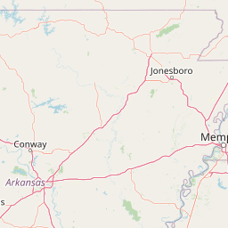
Use this park location map to pinpoint Leatherwood Wilderness in United States of America, understand its exact geographic position, and read its mapped placement within the surrounding landscape more clearly.

Pigeon | © OpenStreetMap contributors

Location context for Leatherwood Wilderness

Arkansas
Recorded earthquake history

Examine the Recorded Earthquake History for the Leatherwood Wilderness Area

Access the comprehensive collection of historical seismic records associated with the Leatherwood Wilderness. This dataset allows for the examination of past event magnitudes, depths, and spatial distances across the Ozark terrain to provide a transparent view of recorded regional activity.

Leatherwood Wilderness Earthquake History

Catalogued events

3 events

Strongest magnitude

Magnitude 3.7

Most recent event

Sep 12, 2019

This history includes earthquakes recorded inside the park or within 50 km of its borders

Park atlas

Compare adjacent Ozark highland landscapes and connected wilderness terrain

Parks Near Leatherwood Wilderness and Surrounding Protected Areas

Browse other protected areas near Leatherwood Wilderness to compare rugged terrain, steep creek drainages, and remote forest habitats across the surrounding region. Continuing into adjacent park geography provides a broader view of Ozark conservation landscapes and regional wilderness preservation.
National parkMissouri
55 km away#1 closest

Northeast

Mark Twain National Forest: Geography and Protected Area Atlas of Southern Missouri

Mapping the karst terrain and ancient ridges of the Ozark Highlands

Mark Twain National Forest represents a sprawling conservation area within the Missouri Ozark Highlands. Its geography is defined by volcanic mountain remnants, rocky glades, and significant river corridors like the Eleven Point National Scenic River. This record provides insight into the forest's complex mapped boundaries, seven designated wilderness areas, and the distinctive karst geology that characterizes this unique American landscape.

Area
6,037.3 km²
Established
1939
Relief
Upland
Climate
Temperate
A soft watercolor illustration featuring a winding river flowing through a green valley with rolling hills in the background, accented by abstract pink blossoms or light reflections.
Wildlife reserveArkansas
About 93 km away#2 closest

West

Richland Creek Wilderness: Mapping Protected Landscapes in the Arkansas Ozarks

A rugged wilderness area and wildlife reserve

Discover the topography and conservation value of Richland Creek Wilderness. This protected area in the Arkansas Ozarks features a complex network of forested hollows, steep sandstone bluffs, and clear creek corridors, offering an essential look at the region's preserved wilderness character and ecological landscape.

Area
48 km²
Established
1984
IUCN
Ib
Relief
Upland
A soft watercolor illustration featuring rolling green hills, a winding stream, and a forested treeline against a pale sky.
Wildlife reserveMissouri
119 km away#3 closest

Northeast

Irish Wilderness: Missouri Ozark Protected Area and Karst Landscape Atlas

Federally protected wilderness in the Eleven Point River landscape

Spanning the rugged terrain of the Missouri Ozarks, Irish Wilderness is a federally protected area known for its distinct karst geography. Visitors can study the network of caves, sinkholes, and springs that define the local environment, alongside historical remnants of frontier settlement. The area serves as a primary example of wilderness preservation within the Mark Twain National Forest, balancing sensitive cave ecosystems with forested ridge landscapes.

Area
65.87 km²
Established
1984
IUCN
Ib
Relief
Upland
Watercolor painting of a forested landscape with soft rolling mountains in the background and vegetation in the foreground.
Protected landscapeArkansas
125 km away#4 closest

Southwest

Ouachita National Forest: Protected Landscape and Mountain Geography in Arkansas

Exploring the ancient ridges and river corridors of the Ouachita Mountains

Ouachita National Forest protects a unique geological system of east-west folded ridges and sandstone bluffs in the interior United States. This expansive region provides vital habitats for diverse hardwood communities and hosts extensive wilderness areas, offering a deep look into the natural history and terrain of the Ouachita Mountain range within Arkansas.

Area
7,221.44 km²
Established
1907
IUCN
VI
Relief
Mountain
A horizontal watercolor painting showing rolling green hills and a small stream in the foreground with faint mountain ridges in the distance.
Wildlife reserveArkansas
137 km away#5 closest

South

Flatside Wilderness: Rugged Sandstone Ridges in the Ouachita Mountains

Arkansas wildlife reserve featuring mountain summits and mapped backcountry

Flatside Wilderness offers a deep look at the high-relief geography of the Ouachita Mountains. Featuring prominent sandstone summits and an 8.9-mile segment of the Ouachita National Recreation Trail, this protected landscape provides essential insight into the state's wilderness systems and regional forest ecosystems.

Area
38.47 km²
Established
1984
IUCN
Ib
National parkGarland County
174 km away#6 closest

South

Hot Springs National Park: National Park Protected Area and Geographic Context

Mapped boundaries and regional landscape of this US National Park.

Gain a structured understanding of Hot Springs National Park, focusing on its identity as a protected national park. Examine its mapped geography and regional landscape context within Garland County, providing essential details for atlas-based exploration. This entry details the park's protected area and its position in the broader geographic framework.

Area
22.5 km²
Established
1832
IUCN
II
Visitors
2.6M annual
Protected landscapeArkansas
About 203 km away#7 closest

Southwest

Ozark, St. Francis National Forest: Geographic Overview of Arkansas Protected Wilderness Areas

Mapping rugged mountain slopes and Mississippi River floodplains.

This geographic profile of Ozark, St. Francis National Forest details the distinct ecological divide between the northern Ozark Mountain units and the eastern St. Francis ridge landscape. Use this data to trace the boundaries of old-growth pine stands, karst topography, and river-bottom habitats within one of Arkansas's most significant federal forest management systems.

Area
4,693.55 km²
Established
1908
Relief
Mountain
Climate
Temperate
Wildlife reserveMissouri
About 211 km away#8 closest

Northeast

Mingo Wilderness: Missouri Protected Wildlife Reserve and Wetland Geography

Primitive bottomland forest and swamp landscape

Mingo Wilderness encompasses 8,000 acres of protected bottomland hardwood forest and cypress-tupelo swamp in southeastern Missouri. As a federally designated wilderness area embedded within a national wildlife refuge, it provides a quiet, primitive habitat characterized by slow-moving creek corridors and varied seasonal wetlands.

Area
32 km²
Established
1976
IUCN
Ib
Relief
Lowland

Common questions about visiting, size, designation, and location context for Leatherwood Wilderness

Leatherwood Wilderness FAQs for park facts, access, geography, and protected area context

Find quick answers about Leatherwood Wilderness, including protected-area facts, park geography, trail and visitor context, and how the park fits into its surrounding country and regional landscape.
MoriAtlas Explorer

Continue Your Protected Areas Search Across the Global Atlas

Deepen your exploration by continuing the structured search for national parks and protected areas worldwide. Utilize the comprehensive filtering capabilities to compare different conservation landscapes and refine your understanding of global park geography. Discover more about the distribution and characteristics of protected natural areas.

Global natural geography