

Mori Atlas logo
Protected areaLeezener Au

A detailed geographic study of glacial terrain, lowland peat corridors, and riparian conservation

Leezener Au: Exploring the Glacial Tunnel Valley and Protected River Landscapes of Schleswig-Holstein

The Leezener Au forms a vital protected lowland corridor within Schleswig-Holstein, defined by its deeply cut glacial tunnel valley and complex riparian ecosystems. This landscape atlas entry maps the intersection of wet meadows, sandy ridges, and hillside woodlands that characterize the stream's path toward the Trave basin. Ongoing renaturation efforts restore natural flow patterns, emphasizing the ecological connectivity between northern Germany's inland habitats and the wider Baltic Sea water system.

glacial lowlandtunnel valleywet meadowslowland peatriparian corridorFFH habitat

Leezener Au

Protected area

Park overview

Structured park overview, official facts, and landscape profile for Leezener Au

Leezener Au park facts, protected area profile, and essential visitor context

Review the core facts for Leezener Au, including designation, size, terrain, visitor scale, habitats, and operating context in one park-focused overview.

About Leezener Au

The Leezener Au is a short lowland stream in Schleswig-Holstein that, despite its modest length, sits at the heart of a carefully protected valley landscape. It rises as the overflow of Lake Neversdorf close to the village of Leezen and flows northward for roughly five kilometers before reaching Lake Mözen near Kükels. From there its waters continue through the Mözener Au into the Trave, which eventually empties into the Baltic Sea. The stream is therefore part of one of northern Germany's most important river systems, even though the watercourse itself is small.

The valley around the Leezener Au was formed during the Ice Ages, when advancing and retreating glaciers carved deep tunnel valleys and left behind sandy deposits. The result today is a soft, water-rich lowland with wet meadows, partially silted-up lakes, lowland peat remnants, and steep valley flanks crowned with mixed forest. Until the 1960s this landscape was shaped by traditional grassland use and, in places, by drainage and channelization of the small watercourses, which gradually reduced habitat diversity. Since 2005 a comprehensive renaturation programme has been working to restore natural stream patterns, re-wetten soils, and revive the ecological character of the valley.

Although the Leezener Au itself is only a few kilometers long, the protected corridor it runs through gives it real ecological weight. The valley and the adjoining hillside woodlands have been designated as an FFH (Flora-Fauna-Habitat) area, recognizing their value for endangered habitats and species typical of glacial lowlands. For visitors and naturalists, the Leezener Au represents the kind of quiet, overlooked landscape that defines much of Schleswig-Holstein's inland scenery: a small river threading through a valley where nature, hydrology, and human land use have visibly intersected over centuries.

Quick facts and research context for Leezener Au

The Leezener Au lies in the Segeberg district of Schleswig-Holstein, Germany, within the Trave river system. It runs about 5.2 kilometers from Lake Neversdorf near Leezen to Lake Mözen near Kükels, continuing onward toward the Baltic Sea via the Trave.

The surrounding lowland is of glacial origin and is characterized by a tunnel valley, sandy deposits, wet meadows, partially silted-up lakes, and lowland peat. Much of the valley was drained and straightened for farmland through the 1960s; since 2005 it has been the focus of a broad renaturation programme, and the riparian corridor plus adjacent hillside forests are protected as an FFH (Flora-Fauna-Habitat) site.

Protection and recognition

Explore documented terrestrial protection metrics and official designation scope for Leezener Au.

Leezener Au Protection Status and International Recognition Records

Terrestrial protection metrics for Leezener Au outline the documented conservation scope and administrative standing of the protected area. Official designation records provide structured oversight data for geographical analysis without assuming unverified international frameworks.

Protection details

Protection scope
Terrestrial
Transboundary protection
No
Park context

Deeper park guide and search-rich context for Leezener Au

Leezener Au history, landscape, wildlife, and travel context

Explore Leezener Au through its history, landscape character, ecosystems, wildlife, conservation priorities, cultural context, and seasonal travel timing in a structured park guide built for atlas discovery and search intent.

Why Leezener Au stands out

The Leezener Au is best known as a small stream that anchors a much larger glacial landscape story: a tunnel valley filled with wet meadows, lowland peat, partly overgrown lakes, and adjoining hillside woods. Its defining identity is its protected lowland corridor, the long-running renaturation effort, and its role as a habitat link within the Trave basin leading to the Baltic Sea.
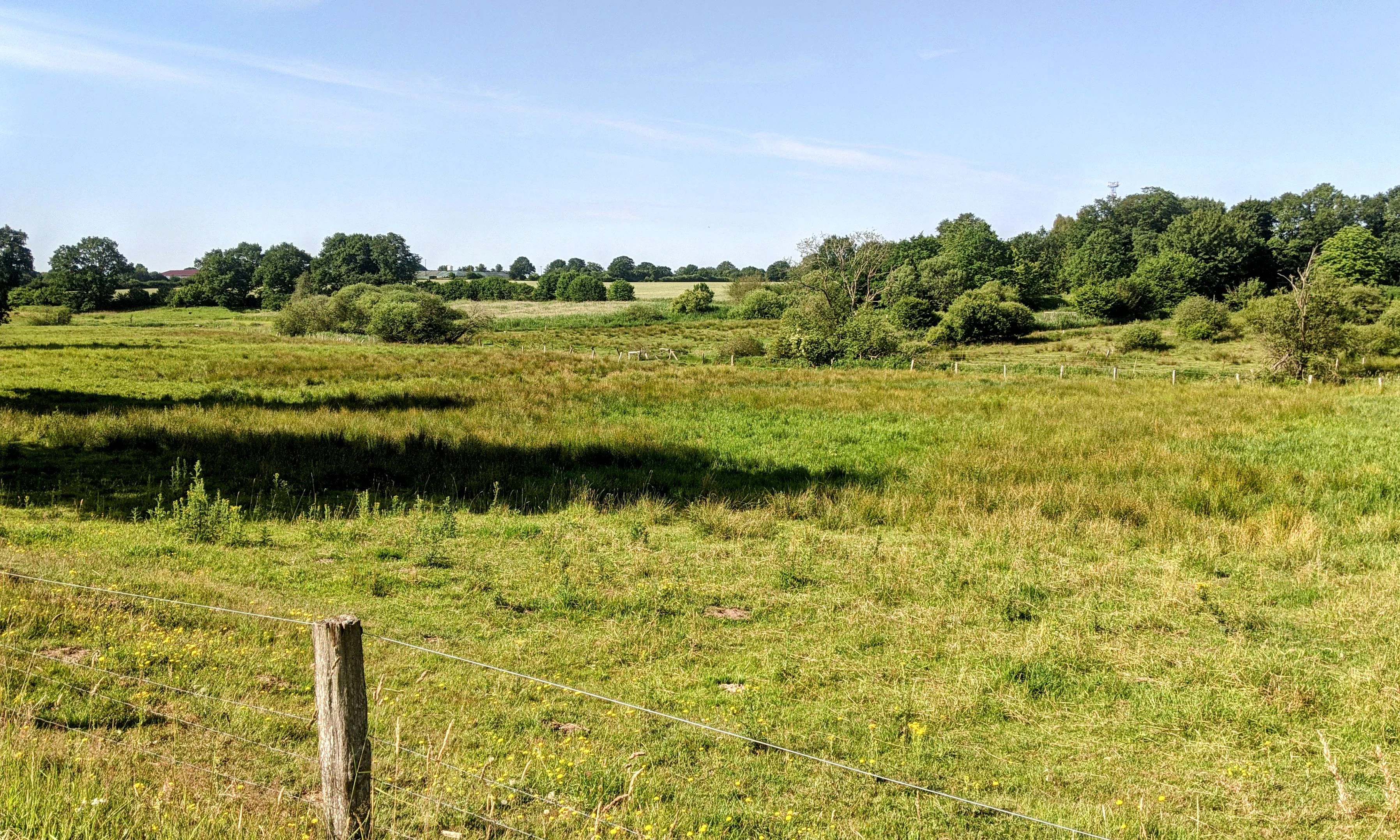
A wide shot of a green grassy field with a wooden fence post and wire in the foreground, transitioning to darker marshy patches and a line of trees in the background under a blue sky.
The grassy lowlands of the Leezener Au with a wire fence in the foreground.

Leezener Au history and protected-area timeline

Until the 1960s, the lowland around the Leezener Au was used extensively as grassland, and the small watercourses of the valley, including the Au itself, were straightened to ease agricultural drainage. Together these interventions reduced habitat variety and contributed to a measurable decline in biodiversity in the valley.

In 2005 a broad renaturation programme was launched to reverse these changes. The effort includes restoring more natural stream courses, reviving wet meadow and peatland conditions, and reconnecting fragmented habitat along the valley floor. As a parallel step, the riparian corridor and adjacent hillside forests have been formally designated as an FFH (Flora-Fauna-Habitat) area, giving the landscape long-term protected status within the European Natura 2000 network.

Leezener Au landscape and geographic character

The valley of the Leezener Au is a textbook example of a glacial lowland in northern Germany. Glacial action carved the deeply cut tunnel valley that the stream follows, while retreating ice left sandy ridges and deposits that shape the surrounding slopes. Today the valley floor alternates between wet meadows, lowland peat, and partially silted-up lakes, and the slopes above the stream drop into a corridor of mixed hillside woodland.

This combination of steep forested flanks, soft valley bottom, sandy slopes, and standing water defines much of the scenery around the stream. The varied micro-topography creates a patchwork of dry and wet habitats within a small area, which is precisely the feature that makes the Leezener Au's landscape worth protecting.

Leezener Au ecosystems, habitats, and plant life

Ecologically, the Leezener Au valley is defined by the mix of habitats compressed into a small glacial corridor. Wet meadows and lowland peat bogs anchor the valley floor, while raised bog remnants, sandy deposits, and partially overgrown lakes add further habitat variation. The slopes above the stream carry mixed hillside forest, which acts as both a buffer and a refuge species for many woodland-associated invertebrates and birds.

Together these habitats support the kind of species communities typical of glacial lowlands in Schleswig-Holstein, a profile that is now formally recognized through the area's FFH designation. The renaturation since 2005 has aimed specifically at restoring natural stream dynamics, rewetting peat areas, and re-establishing a more natural mosaic of grassland and wetland habitat.

Leezener Au conservation status and protection priorities

The Leezener Au's conservation significance lies less in the stream itself than in the valley it drains. The riparian zone and adjoining hillside forests have been designated as an FFH (Flora-Fauna-Habitat) area, integrating the site into the European Natura 2000 network and protecting habitat types that have become rare in intensively managed lowlands.

Since 2005 a multi-year renaturation programme has addressed the long-term loss of biodiversity caused by twentieth-century drainage, channelization, and grassland intensification. The work focuses on restoring natural watercourses, rewetting soils, maintaining peat-forming conditions, and rebuilding the structural diversity of the valley. For an otherwise modest stream, the Leezener Au therefore carries a disproportionate share of conservation responsibility within the Trave basin.

Top sights and standout views in Leezener Au

The standout features of the Leezener Au include its setting within a deeply cut glacial tunnel valley, its chain of wet meadows, lowland peat, and partially silted-up lakes along the valley floor, and the mixed hillside forests that frame the corridor. Its FFH protected status and the ongoing post-2005 renaturation programme give the site real conservation weight, while its connection to the Trave and the Baltic Sea ties it into one of northern Germany's defining river systems.

Best time to visit Leezener Au

The Leezener Au's valley is most attractive in late spring and summer, when wet meadows are in active growth, peat surfaces hold water, and the contrast between grassy lowland and forested slopes is sharpest. Early mornings and evenings through these seasons are also when wetland and woodland wildlife is most active along the corridor.

In autumn and winter the valley softens visually, with wetland surfaces and quieter conditions, though access can be more limited by weather and ground conditions. Spring brings rising water levels and renewed wetland activity, while high summer offers the richest biodiversity experience during drier spells.

Monthly climate preview

Long term temperature ranges and monthly precipitation patterns recorded for Leezener Au

Leezener Au Climate Normals, Average Temperature and Precipitation by Month

Historical climate normals trace the annual temperature progression and monthly precipitation rates recorded at representative coordinates in Leezener Au. Full monthly data breakdowns provide complete multi-year averages for temperature minimums and maximums across the protected area.
Annual mean9 °C
1 °C18 °C
Jan
Feb
Mar
Apr
May12°
Jun15°
Jul18°
Aug17°
Sep14°
Oct
Nov
Dec
Warmest month
July

17.7 °C

Coolest month
January

0.6 °C

Wettest month
July

2.5 mm/day

Driest month
April

1.4 mm/day

Park location guide

Geography guide, regional context, and park location map for Leezener Au

Leezener Au park geography, regions, and map view in Germany

Understand where Leezener Au sits in Germany through a broader geographic reading of the surrounding landscape, nearby location context, and its mapped position within the national park landscape.

How Leezener Au fits into Germany

Germany is a federal republic in Western and Central Europe with a population of over 83 million across sixteen constituent states. It is Europe's largest economy by nominal GDP and a major global exporter and importer. The capital is Berlin, and the country borders Denmark, Poland, Czech Republic, Austria, Switzerland, France, Luxembourg, Belgium, and the Netherlands.

Wider geography shaping Leezener Au in Germany

Germany is located in Western and Central Europe, spanning 357,022 km². It borders Denmark to the north, Poland and the Czech Republic to the east, Austria and Switzerland to the south, and France, Luxembourg, Belgium, and the Netherlands to the west. The country has coastlines on the Baltic Sea and North Sea to the north, with the Alps located in the southern region.

Map view of Leezener Au

Use this park location map to pinpoint Leezener Au in Germany, understand its exact geographic position, and read its mapped placement within the surrounding landscape more clearly.

Pigeon | © OpenStreetMap contributors

Location context for Leezener Au

Schleswig-Holstein

Visualizing the tunnel valley, wet meadows, and protected habitats of the riparian corridor.

Leezener Au Photos and Glacial Landscape Scenery in Northern Germany

Visual documentation reveals the complex glacial topography and protected lowland character defining the Leezener Au environment. Photographic records capture the deeply cut tunnel valley, wet meadows, and mixed hillside woodlands that anchor this regional river ecosystem.

A wide shot of a green grassy field with a wooden fence post and wire in the foreground, transitioning to darker marshy patches and a line of trees in the background under a blue sky.

A river flowing through a green landscape with large trees on the left, a small wooden bridge crossing the water in the middle distance, and a wooden information sign standing in a grassy field on the right under an overcast sky

Park atlas

Compare surrounding glacial landscapes and regional conservation corridors

Explore Protected Areas and Nearby Parks Around Leezener Au

Browse other protected areas and nearby parks sharing the glacial lowland terrain and river valley characteristics of Leezener Au. Expanding the geographic comparison reveals connected natural habitats and regional conservation networks across the surrounding territory.
Natural monumentSchleswig-Holstein
About 8.7 km away#1 closest

Northeast

Kalkberghöhle Natural Monument: Geological Profile and Protected Karst Landscape in Schleswig-Holstein

Mapping a unique gypsum cave and biological refuge

Located in Bad Segeberg, Kalkberghöhle represents a significant karst formation emerging from the young moraine landscape of northern Germany. The site showcases a rare phreatic gypsum cavern morphology and serves as one of the most vital subterranean bat hibernation habitats in Europe. This protected natural monument offers a distinct look into the interaction between salt tectonics and glacial surface geology.

Established
1913
Visitors
42.2K annual
Relief
Upland
Climate
Temperate
Nature reserveSchleswig-Holstein
About 17 km away#2 closest

North

Tarbeker Moor Nature Reserve and Glacial Peatland Basin Geography

A restored wetland landscape in Schleswig-Holstein, Germany

Tarbeker Moor functions as a crucial nature reserve that showcases the successful rewetting of a former industrial peatland. Located in a shallow glacial meltwater channel north of Bad Segeberg, the park offers a distinct study in landscape recovery, featuring a dense mosaic of open water, floating vegetation, and diverse amphibian habitats.

Area
1.31 km²
Established
2004
Nature reserveSchleswig-Holstein
About 25 km away#3 closest

East

Kannenbruch Nature Reserve in Schleswig-Holstein: A Regional Atlas of Protected Woodland Geography

Mapping the radial forestry lanes and bog-forest ecosystems

Kannenbruch represents a distinctive intersection of cultural history and natural succession within Schleswig-Holstein. The reserve protects a waterlogged, low-lying bog-forest characterized by its deliberate, star-shaped layout of radiating forestry lanes. This structured landscape provides a window into Biedermeier-era spatial planning while supporting a rich diversity of spring-flowering geophytes on its damp, heavy soils.

Area
0.25 km²
Established
1995
Relief
Lowland
Climate
Temperate
Nature reservePinneberg
About 30 km away#4 closest

Southwest

Himmelmoor Nature Reserve and Mapped Peatland Landscape in Pinneberg, Germany

Detailed geography of a restored raised bog

Trace the extensive bog terrain of Himmelmoor in Pinneberg, Germany. This former raised bog is now a focal point for large-scale wetland rewetting. Explore the site's flat, waterlogged geography, industrial heritage, and its protected status as a crucial natural mosaic within the broader regional landscape.

Established
2022
Relief
Lowland
Climate
Temperate
Access
Easy access
Protected landscapeSchleswig-Holstein
About 34 km away#5 closest

Northeast

Naturpark Holsteinische Schweiz: Geographic Atlas of a Northern German Protected Landscape

Lake-dense glacial regions and forest habitats in Schleswig-Holstein.

Spanning 75,000 hectares across the districts of Ostholstein, Plön, and Segeberg, Naturpark Holsteinische Schweiz offers a rich look at a classic post-glacial landscape. This structured overview details the park's intricate network of lakes, winding streams like the Schwentine, and restored peatlands that support essential waterbird habitats. Gain a deeper understanding of the park's topography, from the Bungsberg ridges to the expansive lowland depressions that define this region.

Area
753.28 km²
Established
1986
Relief
Upland
Climate
Temperate
Nature reserveSchleswig-Holstein
About 43 km away#6 closest

Northwest

FFH-Gebiet Wennebeker Moor und Langwedel Nature Reserve: Geographic and Landscape Atlas

Protected mire and heathland complex in Schleswig-Holstein

The FFH-Gebiet Wennebeker Moor und Langwedel nature reserve encompasses a complex mosaic of wet and dry heath, quaking bogs, and Nardus grasslands. This site is distinguished by its unique integration of conservation obligations with active military land use, creating a rare habitat environment within a gently rolling morainal landscape.

Area
2.3 km²
Established
2004
Relief
Lowland
Climate
Temperate
Nature reserveSchleswig-Holstein
About 43 km away#7 closest

North

Wald nordwestlich Boksee Nature Reserve: Geographic Atlas and Protected Landscape Mapping

Ancient deciduous woodland within the Schleswig-Holstein moraine region

Wald nordwestlich Boksee stands as a protected nature reserve representative of Central European beech and oak ecosystems. Situated in the Plön district of Schleswig-Holstein, the site offers a detailed look at glacial moraine landscapes, historic boundary embankments, and the ecological management of ancient woodland habitats. This overview provides mapping context and structural insights into the forest's role within the local biodiversity corridor.

Area
0.25 km²
Established
2004
Relief
Upland
Climate
Temperate
Protected landscapeSchleswig-Holstein
About 43 km away#8 closest

Southeast

Naturpark Lauenburgische Seen: A Detailed Look at Protected Landscapes in Northern Germany

Glacial moraine terrain and lake-dense regional geography

Naturpark Lauenburgische Seen encompasses a vast glacial moraine landscape in southeastern Schleswig-Holstein, featuring over 40 distinct lakes and expansive forest cover. This protected area serves as a vital ecological corridor that links directly to the Schaalsee Biosphere Reserve, highlighting the unique intersection of medieval trade routes and ancient water-carved geology.

Area
470 km²
Established
1961
Relief
Upland
Climate
Temperate

Common questions about visiting, size, designation, and location context for Leezener Au

Leezener Au FAQs for park facts, access, geography, and protected area context

Find quick answers about Leezener Au, including protected-area facts, park geography, trail and visitor context, and how the park fits into its surrounding country and regional landscape.
MoriAtlas Explorer

Continue Your Protected Areas Search Across the Global Atlas

Deepen your exploration by continuing the structured search for national parks and protected areas worldwide. Utilize the comprehensive filtering capabilities to compare different conservation landscapes and refine your understanding of global park geography. Discover more about the distribution and characteristics of protected natural areas.

Global natural geography