
Mori Atlas logo
Nature reserveLeinawald

Discover the mapped terrain, historic pond networks, and ecological zones within this protected German forest.

Leinawald Nature Reserve: A Detailed Atlas of Protected Forest Landscapes and Geography in Eastern Thuringia

(Naturschutzgebiet Leinawald)

Leinawald spans 1,840 hectares across the eastern Altenburger Land in Thuringia, serving as a critical nature reserve and European Natura 2000 protected landscape. The terrain encompasses a rich mosaic of beech and oak-hornbeam potential woodland, alder swamps, and former industrial quarries that now host unique pond ecosystems. This atlas entry examines the forest's layered history, from its ducal hunting origins to its current status as a managed sanctuary for avian and woodland wildlife.

protected forestnature reservebird sanctuaryNatura 2000FFH habitat siteSPA bird protection area
A flat-style digital illustration of a rural landscape at sunset, featuring rolling green fields, patches of forest, a small lake, a village with red-roofed houses, and wind turbines in the distance.

Leinawald

Nature reserve

Park overview

Structured park overview, official facts, and landscape profile for Leinawald

Leinawald park facts, protected area profile, and essential visitor context

Review the core facts for Leinawald, including designation, size, terrain, visitor scale, habitats, and operating context in one park-focused overview.

About Leinawald

The Leinawald is one of the most thoroughly documented forest reserves in the Altenburger Land. Located in eastern Thuringia near the border with Saxony, it occupies a low plateau of gentle hills and shallow valleys between the Pleiße river system to the west and the Wyhra catchment to the east. The forest's protected status was formalized in 1961 with NSG number 185, and the area has since been folded into the European Natura 2000 network as FFH-Gebiet 142 and the broader bird protection area SPA 44. The reserve covers roughly 1,840 hectares and is bordered by the Schömbach reservoir, the Leipzig-Altenburg Airport, and the Saxon Kohrener Land.

Ecologically, the Leinawald is defined less by its current tree cover than by what lies beneath it. The present forest is dominated by spruce and pine, both of which forestry experts consider poorly suited to a landscape prone to summer drought. Potentially natural vegetation studies divide the area into beech forest on drier sites, oak-hornbeam woodland on loess-covered moist soils, and alder swamp woodland in the wet brook valleys of the Teichgraben system. Small ponds, wet meadows, former quarries, and relict sand pits diversify the habitat structure and provide refuge for amphibians, dragonflies, woodland bird species, deer, and wild boar.

Cultural and historical layers are unusually visible. The forest preserves a ducal forestry legacy from Saxe-Altenburg, subdivided since the eighteenth century into an Upper and Lower Forest along the historic Peniger Chaussee. It also retains a forestry quadrant grid, the legacy forester's house at Wilchwitz, and traces of three former mining or quarrying operations. Most strikingly, the Leinawald incorporates the meadows and disturbed ground around the former Klausa airfield, where wartime relics, abandoned military infrastructure, and a documented mass grave of forced laborers and prisoners of war have shaped modern land-use debates. The area's identity is therefore that of a working, surveyed, and intensively studied forest reserve, where conservation, forestry history, and 20th-century memory intersect on a relatively small, well-mapped terrain.

Quick facts and research context for Leinawald

Leinawald is a Thuringian nature reserve of around 1,840 hectares located in the Landkreis Altenburger Land, east-central Germany. It has been protected since 1961 and carries the German nature reserve number 185; it also overlaps with the European Habitats Directive site FFH-Gebiet 142 'Leinawald' and the bird protection area SPA 44 'Nordöstliches Altenburger Land'. The forest sits on gently rolling terrain rising to about 227 meters above sea level at the Fuchsberg, lying on loess-covered Devonian and volcanic bedrock. Ecological character is defined by planted coniferous forest overlying a natural mosaic of beech, oak-hornbeam, and alder swamp woodland, interspersed with ponds, brooks, wet meadows, former quarries, and sand pits. It is bordered by the Schömbach reservoir, the Leipzig-Altenburg Airport on its western edge, and the Saxon Kohrener Land landscape protection area to the north.

Protection and recognition

Documented terrestrial protection scope, management framework, and Natura 2000 records

Leinawald Protection Status and Official International Recognition Data

Leinawald maintains a documented terrestrial protection scope supported by official Natura 2000 recognition records within the global protected areas database. Conservation tracking consolidates official designation frameworks, administrative boundaries, and international recognition sources into structured data.

International recognition

Protection details

Protection scope
Terrestrial
Transboundary protection
No
WDPA ID
164422
Park context

Deeper park guide and search-rich context for Leinawald

Leinawald history, landscape, wildlife, and travel context

Explore Leinawald through its history, landscape character, ecosystems, wildlife, conservation priorities, cultural context, and seasonal travel timing in a structured park guide built for atlas discovery and search intent.

Why Leinawald stands out

The Leinawald is known as a multi-layered protected forest with overlapping German and European conservation statuses, combining an FFH habitat area and an EU bird protection area in a single landscape. It stands out for its unusual combination of small standing waters, including the Märchensee, Fürstenteiche, Flugplatzteich, and the Teichgraben pond system, along with old quarries and sand pits that have turned into valuable secondary habitats. The forest is also distinctive for the density of historical layers visible in the landscape: medieval forestry, a planned quadrant grid, traces of wartime forced labor and a mass grave, and a deeply studied vegetation history that contrasts today's conifer cover with the original beech, oak-hornbeam, and alder wetland forests. The Märchensee in particular is locally celebrated as a possible source of inspiration for Karl May's novel 'Der Schatz im Silbersee'.
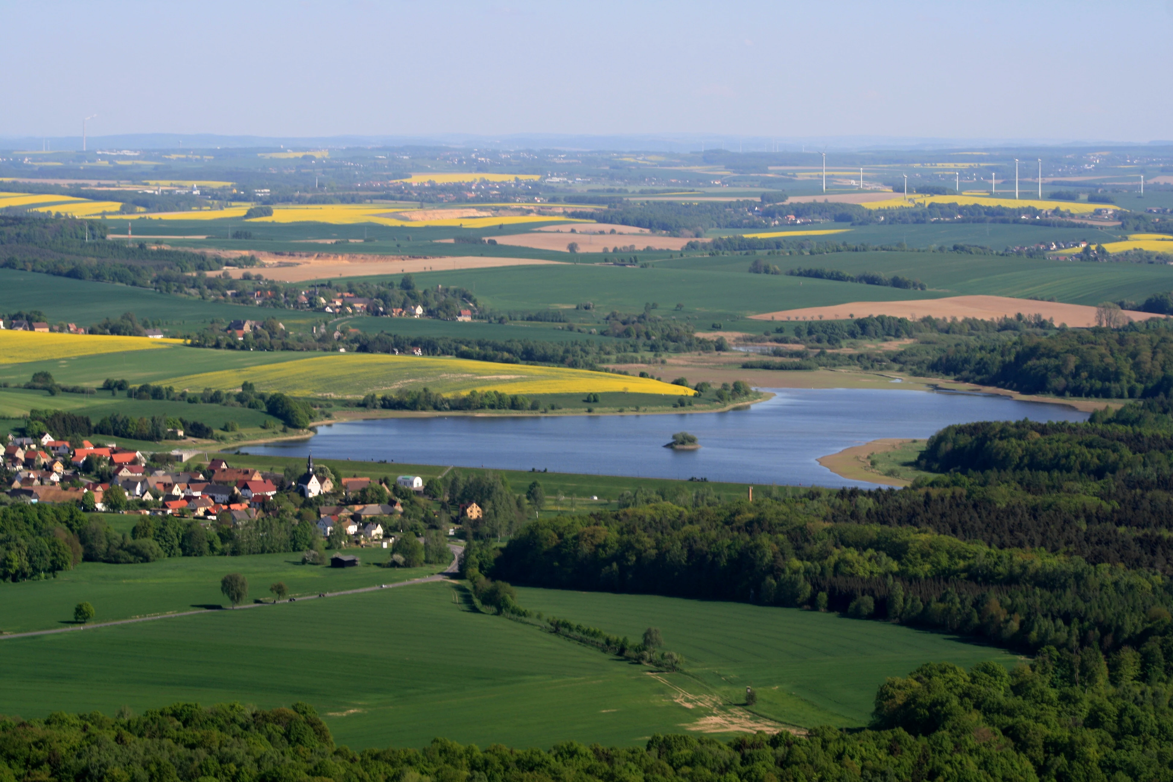
An elevated wide-angle view of a reservoir surrounded by agricultural fields, patches of forest, and a small town.
Aerial view of the Schömbach reservoir and surrounding rural landscape near the Leinawald nature reserve.

Leinawald history and protected-area timeline

The Leinawald's documented history reaches back to early modern cartography and the territorial disputes between Saxe-Altenburg and Electoral Saxony, which by 1723 had already produced detailed forest maps of the contested woodlands around Bocka and Leina. During this period the forest was divided into the Saxon Bocka forest to the north and the ducal Leina in the south, itself further split into an 'Obertheil' (Upper Forest) and 'Untertheil' (Lower Forest) roughly along the line of the later Peniger Chaussee. Forestry administration in Wilchwitz is traceable to at least the medieval period through a documented 'Theodoricus Forestarius de Wilchwitz', and a ducal forestry office has existed at Wilchwitz since 1805. An additional Oberförsterei was located at Zschernichen, and a forester's house stood near the now-vanished village of Schömbach.

To support systematic management, the forest was laid out as a grid of quadrants, each roughly 333 by 666 meters, intersected by named clearing lines (A through H) running north-northeast and numbered east-west forest roads. This geometric framework was already a feature of the pre-1900 Saxe-Altenburg forest maps and has continued to shape navigation, research, and planning ever since. In 1764 the Leina was sown with pine and spruce from external seed stock, beginning the conversion of the original broadleaf forest into a planted conifer woodland.

The early twentieth century brought heavy disruption. With the construction and expansion of the military airfield at Klausa, successive waves of forest clearance shrank the woodland's footprint, particularly during the National Socialist buildup of the Fliegerhorst. After 1990 and the withdrawal of Soviet forces in 1994, part of the adjacent Bockaer Forest was privatized and partly converted to farmland, further reducing the effective forest area. In 2011 and 2012, volunteers and the Volksbund Deutsche Kriegsgräberfürsorge recovered the remains of 66 victims of a wartime forced labor and prisoner-of-war camp located near the old Klausa gravel pit, most of whom were young Russian prisoners of war; they were reburied in 2013 at the Nobitz cemetery with bilingual memorial stelae.

Leinawald landscape and geographic character

The Leinawald occupies a low, rolling upland in the eastern Altenburger Land, with elevations ranging from around 200 meters near the northern margin to roughly 227 meters at the Fuchsberg in the northwest quadrant. The terrain is shaped by loess-mantled soils over deeper Devonian and rhyolitic volcanic bedrock, which gives the area its characteristic mix of dry ridges and damper valley floors. Hummocky ground around the former quarries and sand pits adds local relief, particularly near the Märchensee and the Bocka sand pits on the forest's northern flank.

Water defines much of the landscape's texture. Several small brooks carve shallow valleys through the forest: the Spannerbach, the 'oberer' and 'unterer Teichgraben', and the Burzelgraben, all feeding westward or northward into the Pleiße or Wyhra systems. Numerous small ponds, including the Fürstenteiche, the Flugplatzteich, the Ketzerteich, the Leinenteich, and the restored 2016 Elisabethquelle, punctuate the woodland. Wet meadows and alder swamp fragments, especially along the Spannerbachaue and the Teichgraben valley, contrast with the drier, higher beech- and oak-suited slopes.
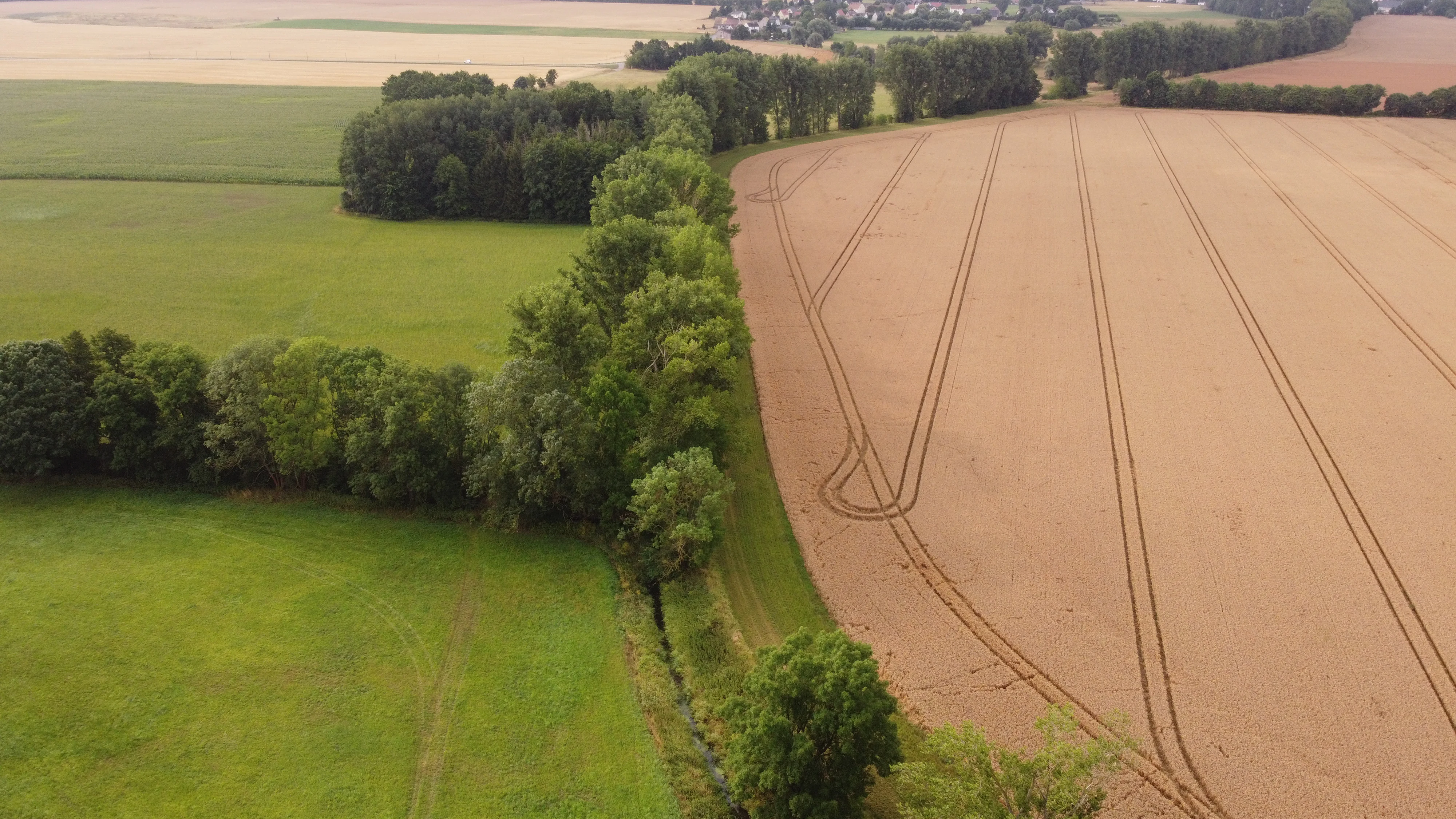
An aerial drone view looking down on a patchwork landscape in Germany, featuring a strip of lush green trees and shrubs dividing a bright green field from a golden, harvested grain field with visible tractor tracks.
Aerial view of the Pleiße meadows, showcasing the transition between cultivated agricultural fields and protected forest vegetation.

Leinawald ecosystems, habitats, and plant life

Ecologically, the Leinawald is best understood as an artificial conifer cover draped over a much richer natural template. The original woodland would have been predominantly deciduous, organized by soil moisture into three characteristic forest communities: beech, or more precisely wood fescue fir-beech forest, on drier sites; oak-hornbeam woodland on loess-covered moist ground; and alder swamp forest in the wettest brook valleys. This potential natural vegetation remains recognizable today and continues to guide forest conversion efforts.

The mosaic of small-scale habitats gives the area unusually high ecological value for its size. Former quarries such as the Märchensee, the old Klausa gravel pit with its glacial erratics, and the Bocka sand pits have become refuges for pioneer vegetation, amphibians, and invertebrates. Numerous Tümpel (small unnamed pools) scattered through all quadrants function as stepping-stone biotopes, while wet clearings around the Erlenbruch and the abandoned shooting range contribute additional habitat diversity. The Teichgraben pond system, in the center of the forest, forms a continuous wet woodland corridor that links to the Spannerbach aue in the northwest.
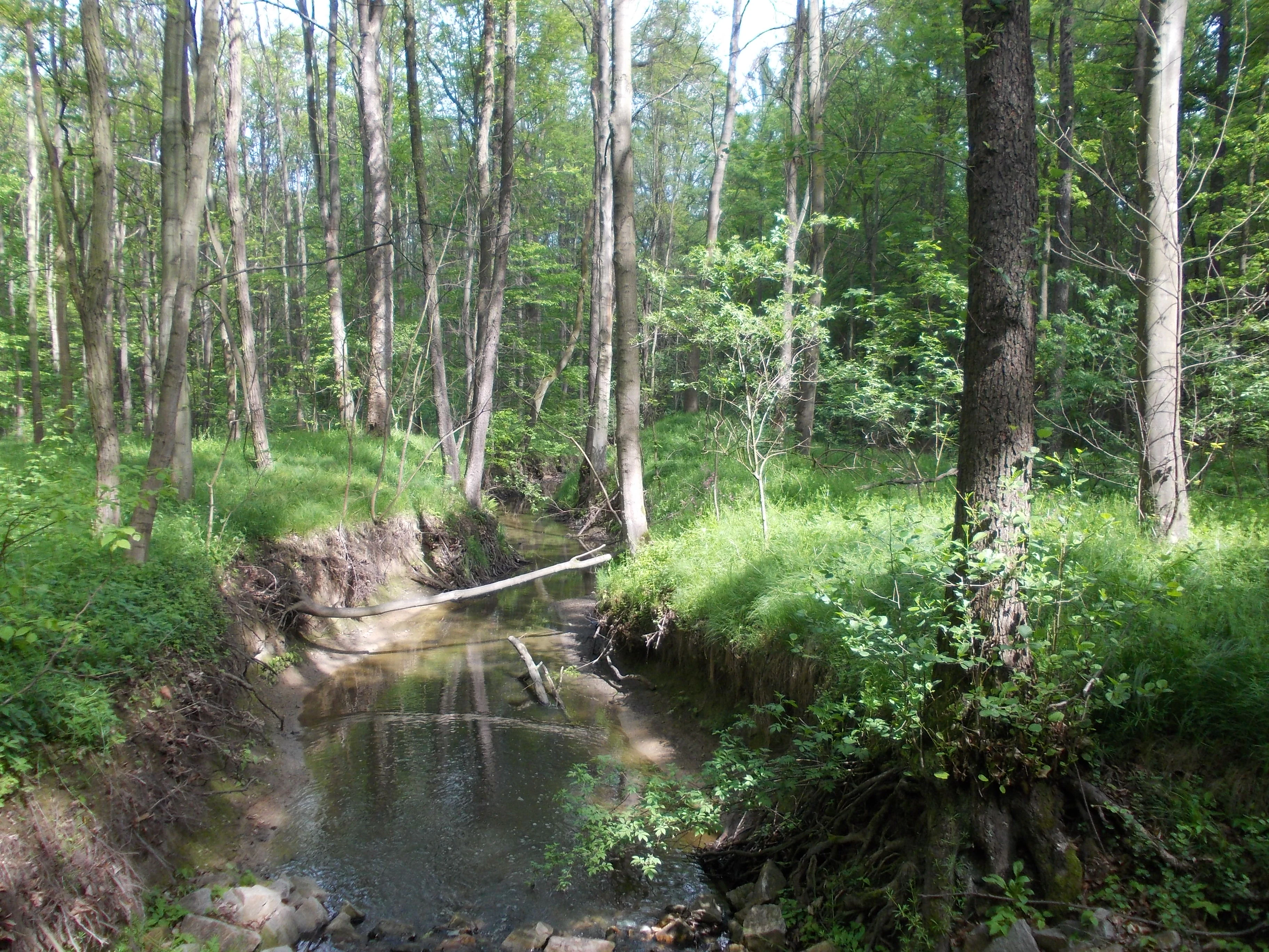
A small, calm stream flows through a lush, green deciduous forest with sunlit trees and exposed roots on the banks.
The Spannerbach stream winding through the dense deciduous forest of Leinawald.

Leinawald wildlife and species highlights

The Leinawald's wildlife profile reflects both its forest cover and its abundant small water bodies. Red, fallow, and wild boar are resident game species managed through drive hunts, while the raccoon appears as an established invasive presence. Amphibians are particularly notable around the ponds and the Märchensee, where frogs, newts, and toads breed in the still water of former quarries and forest pools. Small water bodies also support rare invertebrates and snails, first studied here by Hugo Hildebrandt in 1934.

The forest's bird interest is strong enough to have justified its inclusion in the EU bird protection area SPA 44. Historical studies have documented breeding and feeding populations across the woodland and adjacent reservoir margins, and the Teichgraben system, Fürstenteiche, and wet clearings form the core of this ornithological value. Fish populations include the brook trout, absent from the Spannerbach by 1978 but confirmed again under the 2019 FFH management plan. Insect fauna includes former populations of rhinoceros beetle linked to historic sawmill activity and pre-2019 sightings of the stag beetle in and near the forest.
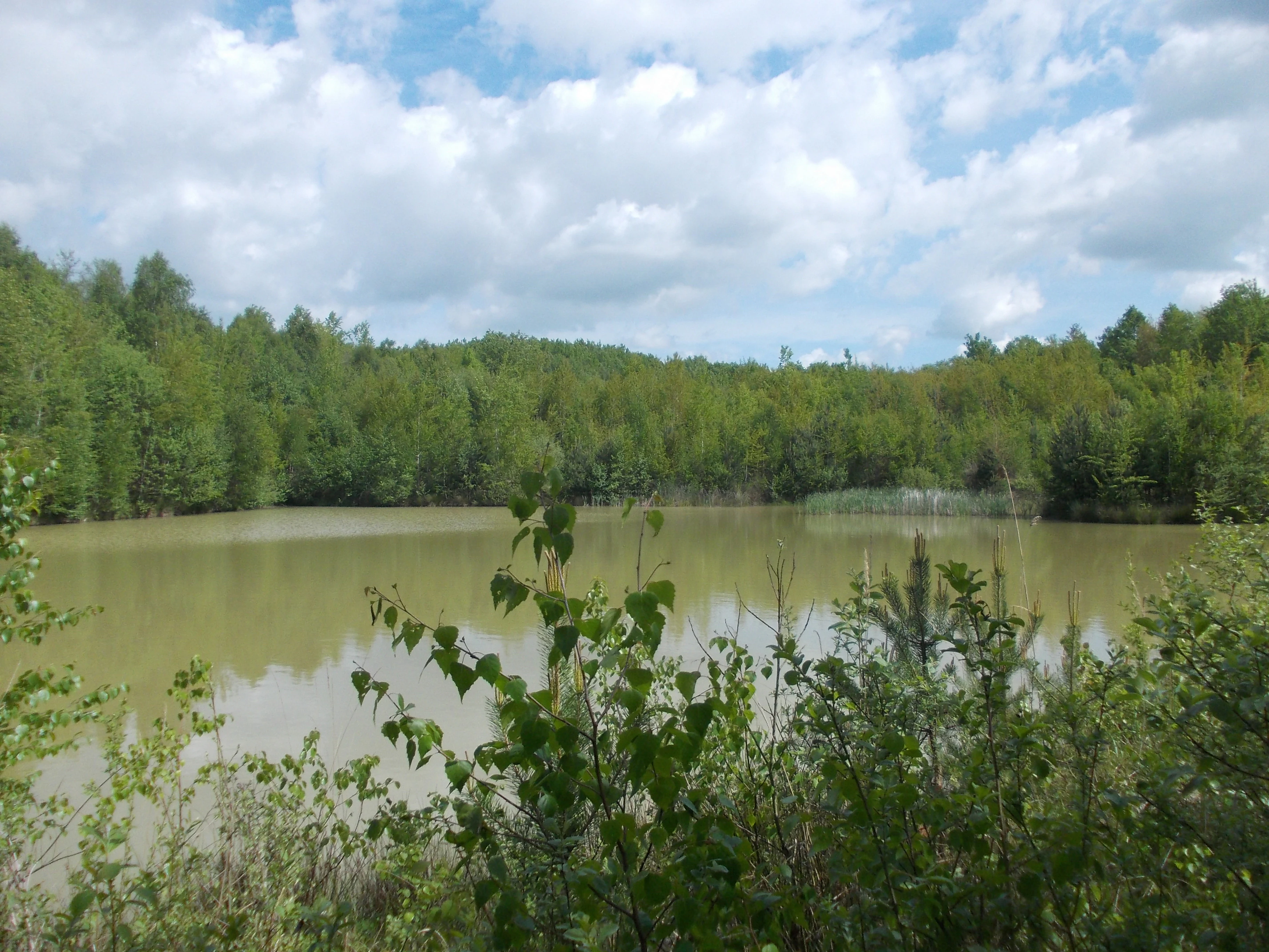
A medium-distance view of a calm, murky-colored pond surrounded by a dense, green deciduous forest under a sky with scattered white clouds.
A tranquil pond surrounded by lush forest within the Leinawald nature reserve.

Leinawald conservation status and protection priorities

Conservation significance in the Leinawald operates on three overlapping levels. As a German Naturschutzgebiet since 1961, it carries the country's strongest standard of habitat protection, with NSG number 185. Since 2004 much of its area has been recognized as FFH-Gebiet 142 under the EU Habitats Directive, and almost all of this lies within bird protection area SPA 44 'Nordöstliches Altenburger Land'. Several sub-sites, including the Märchensee, the Bocka sand pits, and the Teichgrabensystem, hold additional status as Flächennaturdenkmale.

The reserve's conservation challenges are equally distinct. Ongoing drought stress affects the planted spruce and pine, and forestry specialists have argued for decades that the forest should be progressively converted back toward mixed deciduous woodland on natural vegetation lines. Meanwhile, groundwater extraction by the gravel and sand quarries west of the forest at the Nobitz industrial area and former airfield has been linked to declining pond levels, loss of aquatic flora, and changes in amphibian habitat conditions. Neophytes such as Himalayan balsam, water fern, and the originally Leinawald-discovered 'Buntes Springkraut' add a further management dimension, making the Leinawald a long-term laboratory for balancing forestry, water protection, and habitat restoration.

Leinawald cultural meaning and human context

The cultural identity of the Leinawald is unusually layered for a forest of its size. It served as the hunting ground of the Dukes of Saxe-Altenburg, and its forestry history is stitched into local heraldry, with both Langenleuba-Niederhain and Ehrenhain incorporating the forest into their coats of arms. The 'Peniger Chaussee', a historic road now used as a walking and cycling route, traverses the forest as a relic of 19th-century infrastructure. A nature trail laid out for children around 1978 by the conservationist Hartmut Baade reflects the area's role in regional environmental education.

Equally significant is the forest's role as a site of memory. The wartime forced labor and prisoner-of-war camp tied to the Klausa airfield and the HASAG armaments firm left traces that were only systematically uncovered in 2011 and 2012. The reburial of 66 victims at Nobitz in 2013 and the bilingual memorial stelae there have made the Leinawald a focal landscape for local confrontation with the region's 20th-century history. Local literary tradition additionally links the Märchensee to Karl May's childhood and to the inspiration for 'Der Schatz im Silbersee', supported by a new information board at the site.

Top sights and standout views in Leinawald

Key highlights of the Leinawald include the Märchensee, a flooded former quartz-keratophyre quarry with steep banks and amphibian-rich waters; the Teichgraben pond system with its small alder swamp brookland; the Flugplatzteich, the largest pond, sited within the airport approach corridor; the protected Bocka sand pits, which support dry grassland specialists; the 2016-restored Elisabethquelle with its carved shrine to Saint Elizabeth of Thuringia; and the Fuchsberg, the forest's highest point at about 227 meters. Equally distinctive are the cultural sites, including the 'Halbes Schloss' in Langenleuba-Niederhain, the 'Viaduktweg' cycling path on the former Altenburg-Langenleuba railway, the Flughafenmuseum at the old Klausa barracks, and the Nobitz memorial for victims of wartime forced labor.

Best time to visit Leinawald

The Leinawald's character shifts clearly with the seasons. Spring brings vibrant activity around ponds and brook valleys, when amphibians are most visible and deciduous trees leaf out in stark contrast to the persistent conifer cover. Summer is the lushest period for vegetation and the time when insect life around wet clearings and ponds peaks, though high temperatures and periodic drought can lower water levels in smaller Tümpel. Autumn colors the beech and oak stands and is the most atmospheric season for walking the historic Peniger Chaussee and the woodland quadrant trails. Winter is quieter, with frozen ponds and bare deciduous canopy offering the clearest views of the forest's quadrant grid, brooks, and small-scale relief, although some sand-pit and clearing areas may be wetter underfoot.


Monthly climate preview

Long term temperature and precipitation patterns across representative coordinates

Leinawald Climate Normals and Monthly Weather Statistics

Leinawald records measured monthly averages spanning sub zero winter minimums and warm summer peaks alongside steady precipitation rates. Reviewing these long term climate statistics provides a reliable baseline for understanding annual environmental rhythms across the terrain.
Annual mean9 °C
-1 °C19 °C
Jan-1°
Feb
Mar
Apr
May13°
Jun17°
Jul19°
Aug19°
Sep14°
Oct
Nov
Dec
Warmest month
July

19.1 °C

Coolest month
January

-0.9 °C

Wettest month
July

2.7 mm/day

Driest month
April

1.3 mm/day

Park location guide

Geography guide, regional context, and park location map for Leinawald

Leinawald park geography, regions, and map view in Germany

Understand where Leinawald sits in Germany through a broader geographic reading of the surrounding landscape, nearby location context, and its mapped position within the national park landscape.

How Leinawald fits into Germany

Germany is a federal republic in Western and Central Europe with a population of over 83 million across sixteen constituent states. It is Europe's largest economy by nominal GDP and a major global exporter and importer. The capital is Berlin, and the country borders Denmark, Poland, Czech Republic, Austria, Switzerland, France, Luxembourg, Belgium, and the Netherlands.

Wider geography shaping Leinawald in Germany

Germany is located in Western and Central Europe, spanning 357,022 km². It borders Denmark to the north, Poland and the Czech Republic to the east, Austria and Switzerland to the south, and France, Luxembourg, Belgium, and the Netherlands to the west. The country has coastlines on the Baltic Sea and North Sea to the north, with the Alps located in the southern region.

Map view of Leinawald

Use this park location map to pinpoint Leinawald in Germany, understand its exact geographic position, and read its mapped placement within the surrounding landscape more clearly.

Pigeon | © OpenStreetMap contributors

Location context for Leinawald

Thuringia
Recorded earthquake history

Examine the Recorded Earthquake History for the Leinawald Nature Reserve

Explore the historical seismic catalogue for Leinawald to see documented events associated with this region. MoriAtlas provides these records to support a better understanding of the local geological context and recorded history around the forest landscape.

Leinawald Earthquake History

Catalogued events

1 event

Strongest magnitude

Magnitude 3

Most recent event

Aug 4, 2006

This history includes earthquakes recorded inside the park or within 50 km of its borders

Examine the low hills, kettle ponds, and mixed woodland character of eastern Thuringia.

Leinawald Photos and Protected Forest Landscapes: Visual Exploration of Scenery and Habitats

Visual documentation reveals the rolling topography, standing waters, and protected habitats that define the reserve. Field photography illustrates the complex interplay of conifer canopies, wetland pockets, and historical terrain features across the forest.

An elevated wide-angle view of a reservoir surrounded by agricultural fields, patches of forest, and a small town.

A calm, small pond surrounded by a dense deciduous forest, with the forest floor completely covered in fallen brown autumn leaves.

An aerial drone view looking down on a patchwork landscape in Germany, featuring a strip of lush green trees and shrubs dividing a bright green field from a golden, harvested grain field with visible tractor tracks.

A small, calm stream flows through a lush, green deciduous forest with sunlit trees and exposed roots on the banks.

A medium-distance view of a calm, murky-colored pond surrounded by a dense, green deciduous forest under a sky with scattered white clouds.

Park atlas

Compare regional protected areas and adjacent forest reserves in eastern Thuringia.

Other Parks Near Leinawald and Connected Protected Landscapes

Browse protected areas and forested terrain adjacent to Leinawald for wider regional context. This comparison view connects individual forest reserves with broader natural landscapes across the surrounding territory.
A horizontal watercolor illustration depicting a wetland landscape with grassy banks, a winding stream, and reeds.
Nature reserveSachsen
3.5 km away#1 closest

North

Eschefelder Teiche: Protected Wetland Landscapes and Pond Geography in Sachsen

Historic water basins and regional wetland habitats

The Eschefelder Teiche nature reserve occupies a distinctive position in the Saxon landscape, tracing a historic chain of artificial ponds from Frohburg to Eschefeld. This protected area offers insight into managed wetland ecosystems, featuring the expansive Großteich and preserved heritage structures like the Teichhaus complex, which remain central to local conservation and bird populations.

Area
5.62 km²
Relief
Lowland
Climate
Temperate
Access
Easy access
Nature reserveSaxony
About 13 km away#2 closest

East

Um die Rochsburg Nature Reserve: Geography and Protected River Valley Landscapes in Saxony

A vital riverine conservation zone along the Zwickauer Mulde.

Spanning over 250 hectares, Um die Rochsburg protects the steep, wooded slopes of the Zwickauer Mulde and Brausebach valleys. This nature reserve highlights the regional importance of river-influenced terrain and managed habitat corridors within the Mittelsachsen landscape of Saxony.

Area
2.596 km²
Established
1961
IUCN
IV
A horizontal watercolor painting showing a tranquil lake with soft green hills and sparse vegetation along the shoreline under a pale, warm sky.
Nature reserveSachsen
About 13 km away#3 closest

North

Bockwitz Nature Reserve: Mapping the Industrial Reclamation Landscapes of Sachsen, Germany

A Protected Mosaic of Rewetted Lakes and Mining Follow-on Terrain

Spanning 545 hectares, the Bockwitz nature reserve offers a unique look at the transformation of former lignite opencast pits into a thriving wetland habitat. The protected area is characterized by its significant residual water bodies, including Bockwitzer See and the Südkippe pit, which showcase the evolution of Sachsen landscape geography following industrial decline. This site serves as a vital example of habitat management within an anthropogenic environment.

Area
5.454 km²
Established
2003
IUCN
IV
Water
Major water bodies
Nature reserveThuringia
About 18 km away#4 closest

Northwest

Phönix Nord Nature Reserve: Mapped Protected Area in the Altenburger Land of Thuringia

A restored post-mining mosaic of heath, scrub, and woodland

Phönix Nord preserves a unique post-mining landscape shaped by historic lignite extraction. This nature reserve in Thuringia features a mosaic of rewilded slopes and reclaimed mineral soils, managed as a vital habitat for native species. Through its distinct topography and conservation efforts, it stands as a key example of industrial renaturation in central Germany.

Area
1.672 km²
Established
2008
IUCN
IV
Relief
Lowland
A horizontal watercolor illustration showing soft green rolling hills, trees, and a pale yellow sky.
Nature reserveSaxony
About 27 km away#5 closest

North

Alte See, Ruhmberg Nature Reserve: Geographic Atlas of a Protected Landscape in Saxony

Ecological recovery of former military sites in the German lowlands.

Situated in the Landkreis Leipzig, the Alte See, Ruhmberg nature reserve offers a complex study in land use and conservation. The protected area features a unique transition between alder carr wetlands along the Parthe river and the dry, open grasslands of the Ruhmberg hill, creating a high-density biodiversity hotspot within the broader context of Saxon geography.

Area
2.66 km²
Established
2015
IUCN
IV
Protected landscapeThuringia
About 29 km away#6 closest

West

Zaufensgraben Protected Landscape: Geography and Natural Boundaries in Thuringia, Germany

A steep-sided stream valley and protected nature corridor near Gera

Zaufensgraben is a protected landscape corridor centered on a three-kilometer stream valley in Gera, Thuringia. Renowned for its steep gradient within the Weiße Elster system, this area preserves older willow stands and exposes complex Zechstein geology. Its mapped boundaries offer a look at how small-scale protected terrain maintains ecological character within an urbanized historical setting.

Area
0.11 km²
Relief
Upland
Scope
Terrestrial
Water
Minor water
Nature reserveSachsen
About 32 km away#7 closest

Southeast

Um den Eibsee: A Detailed Atlas and Geographic Overview of the Saxony Nature Reserve

Examining the terrain, lake basin, and regional landscape context.

Located near Chemnitz, the Um den Eibsee nature reserve represents a managed cultural landscape spanning 39 hectares. This area integrates the Eibsee lake with surrounding open pastures, protected specifically to prevent habitat loss through active conservation grazing. Gain insights into the boundary mapping and ecological structure that define this unique Saxon protected area.

Area
0.39 km²
Established
2000
IUCN
IV
Relief
Lowland
Nature reserveSaxony
35 km away#8 closest

Southwest

Waschteich Reuth Nature Reserve: Mapped Wetland Landscapes of the Saxony Vogtland

Protected pond habitats and regional woodland ecosystems

Waschteich Reuth serves as a compact yet ecologically rich nature reserve in the Vogtland. Its protected boundaries encompass a traditional pond with floating-leaf vegetation, damp meadows, and native oak-hornbeam forest. This site stands as a prime example of Saxony's wetland heritage, illustrating the importance of small-scale habitat preservation within the broader German river network.

Area
0.212 km²
Established
1995
Water
Major water bodies

Common questions about visiting, size, designation, and location context for Leinawald

Leinawald FAQs for park facts, access, geography, and protected area context

Find quick answers about Leinawald, including protected-area facts, park geography, trail and visitor context, and how the park fits into its surrounding country and regional landscape.
MoriAtlas Explorer

Continue Your Protected Areas Search Across the Global Atlas

Deepen your exploration by continuing the structured search for national parks and protected areas worldwide. Utilize the comprehensive filtering capabilities to compare different conservation landscapes and refine your understanding of global park geography. Discover more about the distribution and characteristics of protected natural areas.

Global natural geography