


Mori Atlas logo
Protected areaLikiep Atoll

Understanding the mapped landscape, expansive central lagoon, and unique maritime heritage of this remote coral atoll

Likiep Atoll Protected Area in the Ratak Chain of the Marshall Islands: A Geographic Map Atlas

Likiep Atoll constitutes a significant protected area within the Ratak Chain of the Marshall Islands, defined by its small landmass and a massive enclosed central lagoon. This geographic entity showcases a distinct maritime landscape where narrow coral islets surround deep interior waters. The area maintains layers of colonial history and features the highest natural point across the entire Marshall Islands territory.

coral atollRatak ChainMarshall IslandsPacific Oceanlagooncolonial heritage

Likiep Atoll

Protected area

Park overview

Structured park overview, official facts, and landscape profile for Likiep Atoll

Likiep Atoll park facts, protected area profile, and essential visitor context

Review the core facts for Likiep Atoll, including designation, size, terrain, visitor scale, habitats, and operating context in one park-focused overview.

About Likiep Atoll

Likiep Atoll is one of the larger atolls of the Ratak Chain in the Marshall Islands, defined by an unusually pronounced contrast between its narrow ring of islands and its expansive central lagoon. The atoll sits in the open North Pacific, with no neighboring landmass close by, and its 65 islands together add up to only a small fraction of the sea area enclosed within its reef. The result is a geography in which life is concentrated along thin strips of land, while the lagoon itself functions almost as an interior sea.

The atoll's identity is shaped as much by its history as by its physical geography. Likiep was visited and charted by Spanish expeditions in the mid sixteenth century, later became a privately purchased copra plantation in the late nineteenth century under the Portuguese trader Anton deBrum, and then moved through successive periods of German, Japanese, and American administration before the Marshall Islands became independent in 1986. Each of these layers left a physical mark, from place names to surviving structures, lending the atoll an unusually rich colonial-era heritage for such a small population.

Today Likiep functions as an administrative district of the Marshall Islands and as a small inhabited community whose livelihoods remain tied to the sea and to traditional coconut-based agriculture. Its deBrum House is listed on the U.S. National Register of Historic Places, and the atoll as a whole is a place where reef geography, lagoon ecosystems, and Pacific island heritage intersect.

Quick facts and research context for Likiep Atoll

Likiep Atoll is part of the Ratak Chain in the Marshall Islands, situated in the North Pacific roughly 55 kilometers northwest of Wotje. The atoll comprises 65 islands with a combined land area of about 10 square kilometers, surrounding a deep central lagoon of roughly 424 square kilometers, one of the larger enclosed lagoons in the chain. Its population is small, on the order of a few hundred people, almost entirely Marshallese.

Protection and recognition

Documented management scope and international recognition records

Likiep Atoll Protection Status and Designated Conservation Scope

Examine the recorded protection status, management scope, and international designation history for Likiep Atoll. Review structured conservation facts and administrative records associated with this protected landscape.

Protection details

Protection scope
Mixed
Transboundary protection
No
Park context

Deeper park guide and search-rich context for Likiep Atoll

Likiep Atoll history, landscape, wildlife, and travel context

Explore Likiep Atoll through its history, landscape character, ecosystems, wildlife, conservation priorities, cultural context, and seasonal travel timing in a structured park guide built for atlas discovery and search intent.

Why Likiep Atoll stands out

Likiep Atoll is best known for its large enclosed central lagoon relative to its tiny land area, its layered sequence of European, German, Japanese, and American colonial-era remains, and its position as the home of the Marshall Islands' highest natural point. The atoll's preserved colonial buildings, including the historic deBrum trading house, also distinguish it from many other atolls in the Ratak Chain.
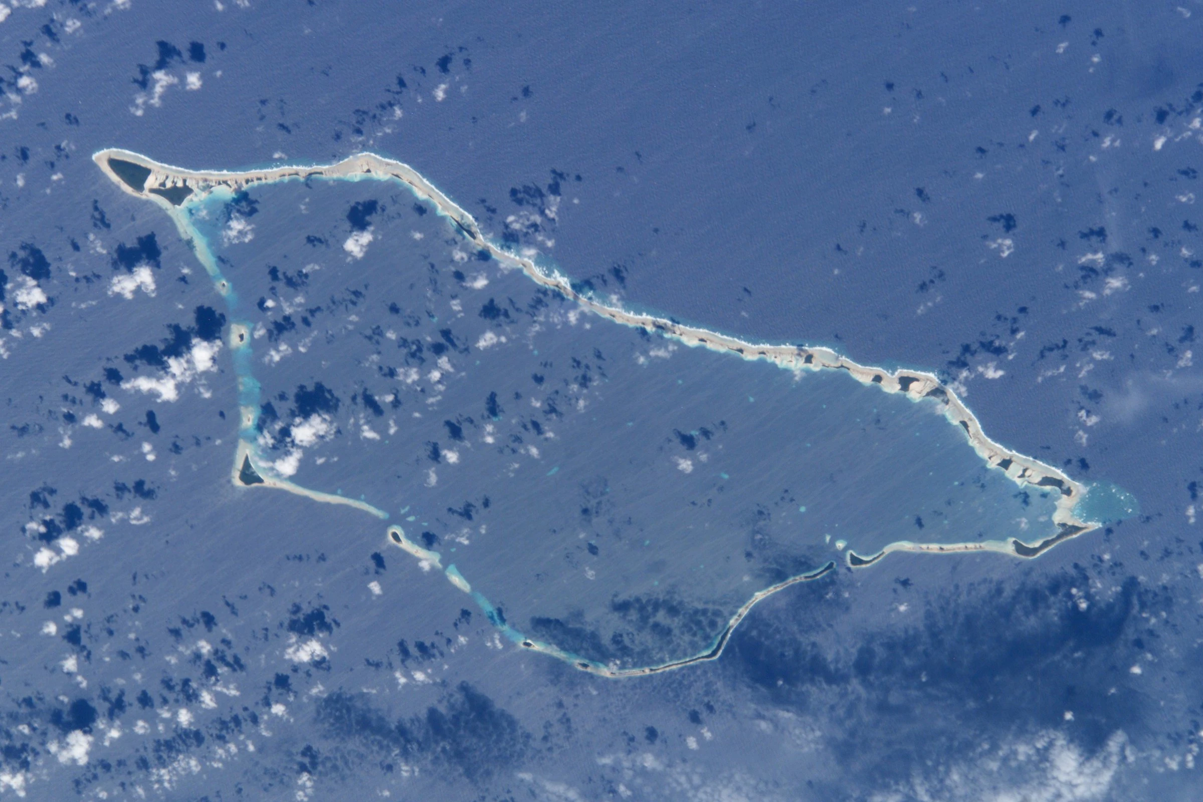
Aerial satellite image of Likiep Atoll, a ring-shaped coral atoll with a large central lagoon surrounded by deep blue ocean and scattered clouds.
Satellite view of Likiep Atoll showing the ring of coral islands surrounding the central lagoon.

Likiep Atoll history and protected-area timeline

The recorded history of Likiep Atoll begins in the sixteenth century, when Spanish expeditions became the first Europeans to document and chart its islands. In January 1543, members of the Ruy López de Villalobos expedition sighted the atoll during their Pacific crossing. More than two decades later, on 5 January 1565, the patache San Lucas under Alonso de Arellano recorded another sighting as part of Miguel López de Legazpi's expedition, which had by then separated from the main fleet; a week later, on 12 January 1565, Legazpi himself arrived and named the atoll Los Corrales, meaning farmyards in Spanish.

In 1877, the Portuguese trader and whaler Anton deBrum purchased Likiep Atoll from the local Iroij Elap Jortaka in exchange for goods. The following year control was transferred to the trading firm Capelle & Co, in which deBrum partnered with the German trader Georg Eduard Adolph Capelle. The company traded extensively in copra and marine products across Micronesia and converted Likiep into a colonial-era copra plantation, planting thousands of coconut trees and drawing labor in from surrounding islands. The atoll also developed a boat-building industry that supplied vessels across the region. In 1885, the Marshall Islands, including Likiep, were claimed by the German Empire.

After the First World War, Likiep passed to the Empire of Japan under the South Seas Mandate. During the Second World War it became part of the broader U.S. Naval Base Marshall Islands network. Following the war the atoll was administered under the Trust Territory of the Pacific Islands, before the Marshall Islands gained independence in 1986. The successive colonial periods have left tangible remains across the atoll, including the Catholic church, the German Plantation Haus, the Japanese community center, the Spanish wharf, the Spanish cistern, and the deBrum House, a Pacific-trader residence dating to 1890 that is now listed on the U.S. National Register of Historic Places.

Likiep Atoll landscape and geographic character

Likiep Atoll is a classic coral atoll, made up of 65 small islands arranged around a deep central lagoon. The total land area is about 10 square kilometers, yet the enclosed lagoon covers roughly 424 square kilometers, giving the atoll a strongly marine character in which land plays a supporting role to the surrounding reef and interior sea. The islands are low-lying, typical of coral atolls in the Ratak Chain, and the highest natural point anywhere on the atoll, an unnamed knoll on one of the islands, reaches only about 10 meters above sea level, which makes it the highest point not only on Likiep but also in the Marshall Islands as a whole.

The atoll lies approximately 55 kilometers northwest of Wotje and stretches across the open North Pacific with no other landmass close at hand. Its lagoon supports a varied reef environment, while the narrow islands hold coconut plantings, coastal vegetation, and small settlements. The combination of shallow reef flats, deeper interior lagoon waters, and string-like islets produces a landscape defined less by mountains or forests than by water, by coral, and by the careful adaptation of human habitation to very limited dry ground.

Likiep Atoll cultural meaning and human context

Likiep Atoll carries an unusually dense cultural and historical imprint for a community of its size, with successive colonial waves leaving visible structures on the islands. The most prominent heritage landmark is Debrum House on Likiep Island, the Pacific-trader house built around 1890 by the deBrum family, which is listed on the U.S. National Register of Historic Places. Other surviving remnants include the Catholic church, the German Plantation Haus, the Japanese community center, the Spanish wharf, and the Spanish cistern, each tied to a different phase of the atoll's administration and trade history.

Lifeways on the atoll today remain Marshallese at their core, with a population of 228 recorded in 2021, but the cultural environment is layered with European, Spanish, German, Japanese, and American influences that arrived through whaling, planting, trading, military, and administrative cycles. Public education is provided through several local elementary schools under the Marshall Islands Public School System, with secondary schooling available in Wotje at Northern Islands High School.

Top sights and standout views in Likiep Atoll

Likiep Atoll stands out for the scale of its central lagoon relative to its land area, its sequence of preserved colonial-era structures from four different imperial and administrative periods, and its possession of the Marshall Islands' highest natural point. The atoll's combination of small population, large enclosed sea, and layered heritage gives it a distinctive profile among the atolls of the Ratak Chain.
Monthly climate preview

Long-term representative records tracking monthly averages across the protected site

Likiep Atoll Climate Normals, Annual Temperature and Precipitation Rhythm

Historical data compiled from NASA Power reveals consistent thermal averages alongside distinct seasonal shifts in rainfall across the protected coordinate point. Reviewing the complete monthly climate breakdown provides deeper insight into long-term atmospheric patterns across the island landscape.
Annual mean28 °C
27 °C28 °C
Jan27°
Feb27°
Mar27°
Apr28°
May28°
Jun28°
Jul28°
Aug28°
Sep28°
Oct28°
Nov28°
Dec28°
Warmest month
November

28.1 °C

Coolest month
February

27.1 °C

Wettest month
October

6.2 mm/day

Driest month
February

1.2 mm/day

Park location guide

Geography guide, regional context, and park location map for Likiep Atoll

Likiep Atoll park geography, regions, and map view in Marshall Islands

Understand where Likiep Atoll sits in Marshall Islands through a broader geographic reading of the surrounding landscape, nearby location context, and its mapped position within the national park landscape.

How Likiep Atoll fits into Marshall Islands

The Marshall Islands is a sovereign island nation in Oceania, located in the Micronesia region of the Northwestern Pacific Ocean. The territory consists of 29 coral atolls and five main islands plus over 1,200 very small ones, divided across two island chains: Ratak in the east and Ralik in the west. The country gained independence from the United States in 1979 and maintains a Compact of Free Association with the US. It is notable for having the highest proportion of water to land of any sovereign state, at 98.62%.

Wider geography shaping Likiep Atoll in Marshall Islands

The Marshall Islands is located in the Micronesia region of the Northwestern Pacific Ocean, west of the International Date Line and north of the equator. The territory is composed of 29 coral atolls and five main islands, plus approximately 1,220 very small islets, divided into two island chains: Ratak (eastern) and Ralik (western). Maritime boundaries are shared with Wake Island to the north, Kiribati to the southeast, Nauru to the south, and the Federated States of Micronesia to the west.

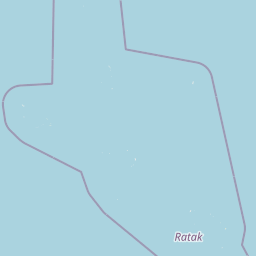
Map view of Likiep Atoll

Use this park location map to pinpoint Likiep Atoll in Marshall Islands, understand its exact geographic position, and read its mapped placement within the surrounding landscape more clearly.

Pigeon | © OpenStreetMap contributors

Explore photographic records of remote islets, vast enclosed lagoons, and low-lying coastal terrain.

Likiep Atoll Photos and Landscape Scenery: Visualizing Coral Reefs and Marine Geography

Visual documentation captures the remote coral atoll environment, illustrating the stark contrast between narrow island strips and expansive central lagoon waters. Photographic observation reveals coastal vegetation formations, shallow reef flats, and the distinct maritime geography defining the protected area.

Aerial satellite image of Likiep Atoll, a ring-shaped coral atoll with a large central lagoon surrounded by deep blue ocean and scattered clouds.

Likiep Atoll Lagoon

Park atlas

Compare surrounding marine geography and regional protected landscapes across the Ratak Chain

Exploring Other Parks Near Likiep Atoll And Connected Regional Protected Areas

Visitors exploring Likiep Atoll can continue browsing adjacent coral formations and regional protected areas across the broader Pacific maritime network. Comparing neighboring marine landscapes reveals distinct lagoon structures, reef ecosystems, and shared geographic patterns throughout the surrounding island chain.
Protected areaMarshall Islands
About 100 km away#1 closest

Northeast

Ailuk Atoll Protected Area: Geography and Mapped Coral Landscapes in the Marshall Islands

Pacific atoll terrain, lagoon systems, and island geography

Study the geographic composition of Ailuk Atoll, featuring its classic ring of coral islets, deep-water reef passes, and vast central lagoon. This protected area offers insight into the subsidence-driven formation of Marshallese island chains and the enduring human reliance on traditional maritime navigation within a fragile Pacific ecosystem.

Area
5.4 km²
Relief
Lowland
Climate
Tropical
Access
Remote access
Protected areaMarshall Islands
About 202 km away#2 closest

Southwest

Kwajalein Atoll Protected Area and Marshall Islands Geographic Landscape Mapping

Pacific coral atoll structure and lagoon geography

Kwajalein Atoll represents a mature coral formation encompassing an immense lagoon within the Ralik Chain. The landscape consists of low-lying islets and interconnected reef structures that define the maritime geography of the Marshall Islands. This assessment provides a focus on the structural, mapped, and physical attributes that distinguish this protected site within the wider Pacific regional context.

Area
16.4 km²
Relief
Lowland
Climate
Tropical
Access
Highly restricted
Protected areaMarshall Islands
About 243 km away#3 closest

Northwest

Rongerik Atoll Protected Area: Mapping the Marshall Islands Coral Landscape

Remote coral atoll geography and lagoon structures in the Ralik Chain.

Rongerik Atoll presents a textbook example of Pacific atoll geography, where a cluster of small islets encloses an expansive lagoon. As a protected area located in the remote Marshall Islands, this site serves as a vital point of study for understanding coral reef systems and the isolated island terrain of the Ralik Chain. The landscape provides clear insights into the physical contrast between narrow coral landmasses and the deep interior waters characteristic of the region.

Area
1.68 km²
Relief
Lowland
Climate
Tropical
Access
Remote access
Protected areaMarshall Islands
About 280 km away#4 closest

Northeast

Bikar Atoll Protected Area: Geographic Overview of a Remote Marshall Islands Coral Atoll

A pristine, uninhabited coral sanctuary and critical Pacific marine habitat.

Bikar Atoll is a remote, diamond-shaped coral ring located in the Ratak Chain of the Marshall Islands. Defined by its shallow lagoon, continuous reef structure, and arid islets, the atoll serves as a vital nesting site for seabirds and green turtles. This protected area remains one of the most ecologically undisturbed sites in the Pacific, offering rare insight into natural atoll morphology and island conservation.

Area
0.5 km²
Established
2025
Relief
Lowland
Climate
Tropical
Protected areaMarshall Islands
About 301 km away#5 closest

Northwest

Rongelap Atoll Protected Area: Geography, Reef Structure, and Marshall Islands Context

Coral atoll terrain in the Pacific Ralik Chain

Located in the Ralik Chain of the Marshall Islands, Rongelap Atoll consists of 61 low-lying coral motus that enclose a lagoon covering 2,600 square kilometers. The atoll serves as a significant geographic study area, known for its distinct reef-built structure and its enduring role in Pacific history. This protected area continues to represent the ecological and cultural complexity of the Micronesian archipelago.

Area
21 km²
Relief
Lowland
Climate
Tropical
Access
Remote access
Protected areaMarshall Islands
About 337 km away#6 closest

Northwest

Ailinginae Atoll Protected Area: Geographic Overview and Mapped Lagoon Systems

Remote coral atoll landscape in the Marshall Islands

Uncover the geographic structure of Ailinginae Atoll, an uninhabited coral ring in the Marshall Islands characterized by its expansive internal lagoon and narrow island segments. This protected area offers significant insight into the terrain of low-lying Pacific atoll ecosystems and their role within the Ralik Chain geographic framework.

Area
2.8 km²
Relief
Lowland
Water
Water-dominated
Protected areaMarshall Islands
About 398 km away#7 closest

Southeast

Majuro: Mapping the Protected Coral Atoll Landscapes and Island Geography of the Marshall Islands

Regional atoll atlas and protected lagoon geography.

Majuro serves as the primary administrative and geographic anchor within the Marshall Islands. This detailed mapping showcases the atoll's signature structure, characterized by 64 narrow islets enclosing a massive, sheltered 295 square kilometer lagoon. Delve into the specific landforms and regional marine geography that define this Pacific protected environment.

Area
9.7 km²
Relief
Lowland
Climate
Tropical
Access
Moderate access
Protected areaMarshall Islands
About 421 km away#8 closest

Southeast

Arno Atoll: A Rare Triple Lagoon Coral Protected Area in the Marshall Islands

Mapped geography and hydrological landscape context

Arno Atoll stands out as a unique geographic entity in the Ratak Chain with its triple lagoon configuration. Spanning 133 islands in the North Pacific, this protected area offers insight into atoll reef systems, low lying coral landscapes, and the environmental framework of the Marshall Islands.

Area
13 km²
Relief
Lowland
Climate
Tropical
Scope
Mixed

Common questions about visiting, size, designation, and location context for Likiep Atoll

Likiep Atoll FAQs for park facts, access, geography, and protected area context

Find quick answers about Likiep Atoll, including protected-area facts, park geography, trail and visitor context, and how the park fits into its surrounding country and regional landscape.
MoriAtlas Explorer

Continue Your Protected Areas Search Across the Global Atlas

Deepen your exploration by continuing the structured search for national parks and protected areas worldwide. Utilize the comprehensive filtering capabilities to compare different conservation landscapes and refine your understanding of global park geography. Discover more about the distribution and characteristics of protected natural areas.

Global natural geography