
Streams
Park geography
Exploration of regional administrative context, terrain elevation, and parkland boundaries.
Comprehensive Geographic Profile and Mapped Boundaries for Llanganates National Park in Ecuador
Examine the technical geographic scope of Llanganates National Park, spanning 2197.07 square kilometers across the provinces of Tungurahua, Pastaza, Cotopaxi, and Napo. This structured profile includes elevation data reaching 4570 meters, alongside mapped river networks, mountain peaks, and alpine habitats within the protected territory.
Related tags
Páramo EcosystemsAndean MountainsCloud ForestProtected AreaAlpine Wildlife
High-Andean páramo wilderness guarding the legendary Treasure of the Llanganatis
Llanganates National Park
Llanganates National Park is a sprawling protected area in central Ecuador that spans the convergent borders of Cotopaxi, Napo, Pastaza, and Tungurahua provinces. Established in 1996, the park encompasses over 219,000 hectares of dramatic Andean terrain, protecting a unique transition zone between the high-elevation páramo grasslands of the western Andes and the lush montane forests that descend toward the Amazon basin. The park's namesake derives from the Llanganati mountains, a range that has become synonymous with one of Ecuador's most enduring legends: the Treasure of the Llanganatis, a vast Incan hoard said to be hidden in the remote wilderness following the Spanish conquest. Beyond its mythological allure, the park offers visitors access to some of Ecuador's most pristine high-altitude ecosystems, with Cerro Hermoso standing as a prominent 4,570-meter peak popular among hikers and mountaineers.
- Location
- Ecuador
- Park type
- National park
- Established
- 1996
- Area
- 2,197.1 km²
- Highest point
- 4,570 m
Location overview
Regional distribution across four Ecuadorian provinces
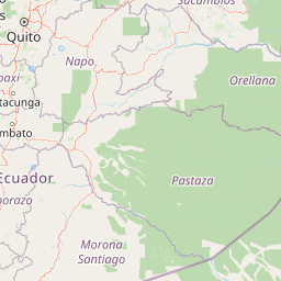
Geographic Location of Llanganates National Park in Ecuador
Llanganates National Park is located in Ecuador, spanning the Tungurahua, Pastaza, Cotopaxi, and Napo provinces. Analyzing provincial distribution provides essential context on how the protected area is managed.
- Countries
- Ecuador
- Regions
- Cotopaxi Province, Napo Province, Pastaza Province, Tungurahua Province
- Primary location
- Ecuador
Boundary and coordinates
A 2,197.07 km² outline with geographic measurements
Llanganates National Park mapped boundary and area
Llanganates National Park is represented by geometry covering its documented 2,197.07 km² extent. The map supplies a spatial frame for the park’s broad landscape without asserting legal-boundary precision.
- Boundary area
- 2,223.2 km²
- Boundary perimeter
- 318.5 km
- Northernmost point
- 0.855° S
- Southernmost point
- 1.426° S
- Easternmost point
- 77.9828° W
- Westernmost point
- 78.4798° W
- Geographic centre
- 1.133° S, 78.2436° W
- North–south span
- 63.1 km
- East–west span
- 55.3 km
Elevation and terrain
Mountain relief metrics and recorded natural geographic features
Llanganates National Park Terrain and Elevation Summary
Recorded park elevation reaches a maximum point of 4570 meters across rugged mountain terrain. Individual feature cards detail specific streams, lakes, and peaks located within the protected boundary.
- Maximum elevation
- 4,570 m
- Highest point
- 4,570 m
Selected named natural features
Streams
Quebrada Los Randios
Streams
Río Millin
Rivers
Quebrada Cajón
Forests
Bosque de polyleis
Rivers
Río Negro
Environmental setting
Alpine climate zones, montane forests, and major water systems across mountain terrain
Llanganates National Park Environmental Classifications and Physical Settings
Recorded landscape features and habitat types provide complementary ways to read the physical setting of Llanganates National Park. Stored environmental categories connect directly to relevant protected area destinations within the atlas database.
- Relief
- Mountain
- Climate
- Alpine
- Water
- Major water bodies
- Forest cover
- Mostly forested
Landscape features
Mountains · Valleys · Forest · Grassland · Wetland · Rivers
Habitat types
Alpine meadow · Grassland · Montane forest · Wetland
Park atlas
Compare the diverse páramo and cloud forest protected areas across Ecuador's central Andes.
Explore Other National Parks Near Llanganates National Park and Surrounding Andean Landscapes
After exploring Llanganates National Park, continue your discovery by browsing nearby national parks and protected areas within Ecuador's central Andean region. Compare varied páramo ecosystems, cloud forests, and high-altitude Andean terrain to understand the broader geographic context of this protected landscape.
National parkEcuador
6.8 km away#1 closest
South

Sangay National Park: Ecuador's National Park for Mapped Landscape and Geographic Discovery
Explore Ecuador's protected area boundaries and regional terrain.
Sangay National Park serves as a crucial protected landscape within Ecuador, offering rich opportunities for atlas and geography exploration. This page details the park's specific mapped boundaries and its natural terrain, providing essential context for understanding its place within South America's broader geographic tapestry. Investigate Sangay National Park's identity as a protected national park and its value for focused landscape and regional discovery.
- Area
- 5,177.65 km²
- Established
- 1979
- IUCN
- II
National parkCotopaxi Province
12 km away#2 closest
Northwest
Cotopaxi National Park: Ecuador's Mapped Protected Landscape and Regional Geography
Explore the geographic context of this national park.
Cotopaxi National Park represents a key protected landscape within Ecuador, located in Cotopaxi Province. This page facilitates detailed exploration of the park's mapped boundaries and its contribution to the regional geography. Understand the specific characteristics of this national park as part of a broader atlas of protected areas and natural terrains.
- Area
- 333.93 km²
- Established
- 1975
- IUCN
- II
- Relief
- Mountain
Biosphere reserveNapo
About 14 km away#3 closest
North
Reserva Biológica Colonso-Chalupas: Protected Landscapes of the Upper Napo Basin
A critical vertical corridor of the Ecuadorian Andes and Amazon.
Reserva Biológica Colonso-Chalupas represents a unique bioclimatic transition, stretching nearly 4,000 meters in elevation. This biosphere reserve serves as a functional corridor connecting high-altitude páramo and cloud forests to warm, humid Amazonian lowlands, forming a key structural element of the eastern Andean conservation landscape.
- Area
- 931.63 km²
- Established
- 2014
- Relief
- Mountain
- Climate
- Alpine
National parkNapo
18 km away#4 closest
North
Parque nacional Antisana: Volcanic Terrain and Andean Protected Area Geography
High-altitude ecosystems spanning Napo and the Andean corridor
Spanning the rugged Cordillera Real, Parque nacional Antisana protects a vast sweep of volcanic terrain dominated by its central stratovolcano. From glacial fields to the water-retention capacity of its páramo wetlands, the area represents a crucial node in Ecuador's conservation network, providing a sanctuary for Andean condors and diverse montane species.
- Area
- 1,205.81 km²
- Established
- 1993
- IUCN
- Ia
- Relief
- Mountain

Wildlife reserveChimborazo
28 km away#5 closest
Southwest
Reserva de Producción de Fauna Chimborazo: Volcanic Landscapes and Andean Wildlife Reserve
High-altitude watershed and páramo geography in central Ecuador.
Spanning from glacial summits to arid puna plains, the Reserva de Producción de Fauna Chimborazo represents a complex Andean ecosystem. This wildlife reserve protects vital watersheds, glacial meltwater sources, and native camelid habitats within the shadows of Ecuador's tallest peaks, offering a detailed look at high-altitude conservation and volcanic terrain.
- Area
- 526.83 km²
- Established
- 1987
- IUCN
- IV
- Relief
- Mountain

Nature reserveEcuador
35 km away#6 closest
Northwest
Reserva Ecológica Los Illinizas: Geographic Atlas and Andean Protected Nature Reserve
Volcanic terrain and cloud forest ecosystems in central Ecuador
Spanning across the provinces of Cotopaxi, Pichincha, and Santo Domingo de los Tsáchilas, Reserva Ecológica Los Illinizas preserves a significant vertical gradient of Andean ecosystems. The reserve protects the western flanks of the Illiniza volcanoes, Quilotoa, and El Corazón, offering a detailed look at high-altitude biodiversity and the transition from rugged mountain peaks to lush western cloud forests.
- Area
- 1,342.33 km²
- Established
- 1996
- IUCN
- Ia
- Relief
- Mountain
National parkEcuador
42 km away#7 closest
Northeast
Sumaco Napo-Galeras National Park: Ecuador's Volcanic National Park Landscape
Explore protected areas and biodiversity in the Andean-Amazon transition.
Sumaco Napo-Galeras National Park protects a dramatic volcanic landscape in Ecuador, showcasing a significant elevation gradient that supports diverse cloud forest and Amazonian rainforest habitats. This national park is recognized for its endemic species and rich avifauna, offering a compelling case study for understanding protected land geography and ecological transitions within South America.
- Area
- 2,067.49 km²
- Established
- 1994
- IUCN
- II
- Relief
- Mountain

Wildlife reservePichincha
About 47 km away#8 closest
North
Refugio de Vida Silvestre Pasochoa: Volcanic Crater and Andean Forest Protected Area
Geographic atlas of the Pichincha volcanic highlands
Located in the Pichincha province, Refugio de Vida Silvestre Pasochoa protects an essential highland habitat defined by its steep volcanic crater walls and dense bamboo stands. This area provides a scientific reference for inter-Andean vegetation, featuring a sharp contrast between forested inner slopes and surrounding agricultural landscapes. Map the ecological gradient of this protected refuge and explore its role within the broader northern Andean geographic context.
- Area
- 9.799 km²
- Established
- 1996
- IUCN
- Ib
- Relief
- Mountain
MoriAtlas Explorer
Continue Exploring Llanganates National Park's Geographic and Landscape Atlas
Dive deeper into the cartographic and geographic significance of Llanganates National Park. Understanding its place within Ecuador's protected areas offers valuable insights for regional landscape analysis and the systematic exploration of natural terrains. This continued discovery enhances your grasp of protected lands and their ecological geography.
Browse next
Global natural geography
Explore related park routes
Explore MoriAtlas Global ParksBrowse All MoriAtlas ParksGlobal Park Map DiscoveryMoriAtlas: Browse All CountriesBrowse All MoriAtlas ContinentsNational Park Environment AtlasGrand Canyon National Park AtlasYellowstone National Park AtlasYosemite National Park Atlas and GeographySerengeti National Park AtlasGalápagos National Park Protected LandscapeBanff National Park Geography and AtlasKruger National Park Atlas EntryUluṟu-Kata Tjuṯa National Park AtlasExplore Uluru-Kata Tjuta National Park GeographyPlitvice Lakes National Park AtlasFiordland National Park Protected LandscapeGreat Smoky Mountains National Park AtlasAfghanistan National Parks and Protected AreasAlbania National Parks and Protected AreasAlgeria National Parks and Protected AreasAmerican Samoa National Parks and Protected AreasAndorra National Parks and Protected AreasAngola National Parks and Protected AreasAntarctica National Parks and Protected AreasAntigua and Barbuda Park List