
Cliffs
Park geography
A comprehensive analysis of terrain elevation, administrative regions, and natural features
Geographic Profile and Mapped Boundaries of Los Nevados National Natural Park in Colombia
Examine the detailed physical geography of Los Nevados National Natural Park, spanning 583 square kilometers across the Risaralda, Quindío, Caldas, and Tolima departments. This profile presents the park boundary, its 5321-meter maximum elevation, and the distribution of internal peaks, volcanic systems, and varied alpine ecosystems within the central Colombian Andes.
Related tags
Volcanic LandscapePáramo EcosystemGlacial MountainsAndean ForestsHigh-Altitude Wetlands
Colombia's high-altitude volcanic paradise of glaciers, páramos and Andean ecosystems
Los Nevados National Natural Park
Los Nevados National Natural Park is a protected area in the Cordillera Central of the Colombian Andes, spanning the departments of Caldas, Risaralda, Quindío, and Tolima. Established in 1973, the park encompasses approximately 58,300 hectares of mountainous terrain centered on Colombia's highest and northernmost active volcanoes, including the glacier-capped Nevado del Ruiz, Nevado del Tolima, and Nevado de Santa Isabel. The park protects critical páramo and super-páramo ecosystems that dominate roughly 80 percent of its area, alongside Andean forests at lower elevations. This strategic location makes the park a vital watershed, feeding rivers that supply water to more than two million residents in the surrounding coffee-growing region. The park's dramatic landscapes feature U-shaped glacial valleys, volcanic craters, and high-altitude wetlands that support exceptional biodiversity, including endemic species such as the buffy helmetcrest hummingbird and the critically endangered wax palm, Colombia's national tree.
- Location
- Colombia
- Park type
- National park
- Established
- 1973
- Area
- 583 km²
- Highest point
- 5,321 m
Location overview
Administrative distribution across four Colombian departments
Geographic Setting of Los Nevados National Natural Park, Colombia
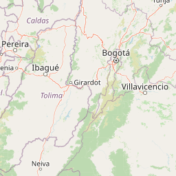
Los Nevados National Natural Park is situated in Colombia across the borders of Tolima, Caldas, Quindío, and Risaralda. Departmental boundaries define the administrative framework for the regional conservation zone.
- Countries
- Colombia
- Regions
- Caldas Department, Quindío Department, Risaralda Department, Tolima Department
- Primary location
- Colombia
Boundary and coordinates
Mapped perimeter geometry and derived area measurements
Los Nevados National Natural Park Boundary Map and Spatial Extent
Spatial context emerges directly from the interactive boundary outline and mapped polygon geometry. Derived measurements provide structured area statistics and coordinate extents for regional reference.
- Boundary area
- 606.2 km²
- Boundary perimeter
- 395 km
- Northernmost point
- 4.9772° N
- Southernmost point
- 4.5928° N
- Easternmost point
- 75.2213° W
- Westernmost point
- 75.5638° W
- Geographic centre
- 4.7706° N, 75.3811° W
- North–south span
- 42.5 km
- East–west span
- 38 km
Elevation and terrain
Mountain relief metrics and recorded natural features
Los Nevados National Natural Park Terrain and Elevation Range
Recorded park elevation metrics outline the vertical range of this protected mountain landscape. Associated natural feature cards detail specific peaks, glaciers, rivers, and wetland formations located within the protected area.
- Highest point
- 5,321 m
Selected named natural features
Rivers
Río Gualí
Lakes
Laguna El Encanto
3,970 m
Streams
Quebrada San Antonio-La Piraña
Streams
Quebrada El Cisne
Streams
Quebrada Los Valles
Environmental setting
Alpine climate zones, glacial relief, and major water systems across protected terrain
Environmental Classifications and Physical Setting of Los Nevados National Natural Park
Recorded landscape features and seasonal classifications outline the physical setting of Los Nevados National Natural Park. Stored environmental categories connect directly to related protected areas and geographic profiles within the atlas.
- Relief
- Mountain
- Climate
- Alpine
- Water
- Major water bodies
- Seasonality
- Strongly seasonal
Landscape features
Mountains · Valleys · Volcano · Glacier · Lakes · Rivers · Wetland · Cave · Forest · Grassland · Woodland · Bog · Marsh · Steppe · Hills
Park atlas
Compare diverse protected areas and their surrounding Andean landscapes, building geographic context.
Explore Related National Parks and Protected Areas Around Los Nevados National Natural Park
Browse other national parks and protected areas geographically connected or ecologically similar to Los Nevados National Natural Park. This allows for comparative exploration of diverse Andean mountain conservation, volcanic terrain, and páramo ecosystems across Colombia's Cordillera Central.
National parkColombia
About 73 km away#1 closest
West

Tatamá National Natural Park: Colombia's Protected Natural Landscape Explorer
Mapped boundaries and regional geography of a Colombian national park.
Tatamá National Natural Park is a protected natural area situated within the Republic of Colombia. As a designated national park, it contributes significantly to the nation's protected lands. This entry provides essential geographic context, focusing on the park's mapped outlines and its role within the broader atlas of Colombian geography. Understanding Tatamá National Natural Park involves appreciating its specific landscape features and its contribution to the country's network of protected natural areas, offering a foundation for regional geographic study.
- Area
- 519 km²
- Established
- 1987
- IUCN
- II
- Relief
- Mountain
National parkColombia
About 127 km away#2 closest
East
Sumapaz National Park: Colombia's Protected National Park Landscape and Geography
Explore its mapped boundaries and regional geographic context.
Sumapaz National Park represents a significant protected area within the broader geographic tapestry of Colombia. As a designated national park, its mapped boundaries are central to understanding its protected landscape identity. This detail page offers focused insight into the park's role in conservation and its specific geographic setting, providing essential context for atlas and map exploration without delving into visitor logistics. Examine the terrain and regional significance of this important natural landscape.
- Area
- 1,780 km²
- Established
- 1977
- Relief
- Highland
- Climate
- Alpine
National parkValle del Cauca Department
About 134 km away#3 closest
Southwest
Las Hermosas National Natural Park: Protected Area Atlas and Geographic Context in Valle del Cauca
Understand the mapped boundaries of this Colombian national park.
Las Hermosas National Natural Park represents a vital protected landscape, offering critical insights into the geography of Colombia's Valle del Cauca Department. This entry delves into the park's specific mapped boundaries and its environmental significance, providing users with structured geographic information for detailed atlas exploration. Gain a clear understanding of the park's identity as a national natural park and its contribution to the regional natural landscape.
- Area
- 1,250 km²
- Established
- 1977
- IUCN
- II
- Relief
- Mountain
National parkColombia
149 km away#4 closest
East
Chingaza National Natural Park: A National Park in Colombia's Geographic Landscape
Mapped boundaries and protected terrain details for Chingaza.
Chingaza National Natural Park offers a distinct entry for exploring Colombia's protected natural areas. This page details the park's specific geographic identity, its mapped boundaries, and its significance as a national park. Understand the landscape context and regional terrain that define Chingaza National Natural Park, providing a foundation for structured discovery within the Colombian atlas.
- Area
- 766 km²
- Established
- 1977
- IUCN
- II
- Relief
- Mountain
National parkValle del Cauca Department
About 185 km away#5 closest
Southwest
Farallones de Cali National Park: Protected Landscape and Geographic Atlas
Explore mapped boundaries and regional context.
Farallones de Cali National Park offers a distinct protected landscape within Valle del Cauca Department. This page provides atlas-level detail on its geographic scope and mapped features, crucial for understanding its regional context. Dive into the protected-area specifics to grasp the natural terrain and conservation landscape that defines this significant Colombian national park.
- Area
- 1,500 km²
- Established
- 1968
- IUCN
- II
- Relief
- Mountain
National parkColombia
About 198 km away#6 closest
Northwest
Las Orquídeas National Natural Park: Colombia's Biodiversity Hotspot and Andean Ecosystem Atlas
Explore its unique elevational gradient and protected terrain.
Las Orquídeas National Natural Park in Colombia is renowned for its dramatic elevational range, compressing multiple distinct ecosystems into a single protected area. This national park offers an exceptional view of Andean geography and Chocó biogeographic region biodiversity, transitioning from tropical rainforest to high-altitude páramo. Investigate the mapped landscape and the conservation significance of this unique natural treasure.
- Area
- 287.53 km²
- Established
- 1974
- IUCN
- II
- Relief
- Mountain
National parkValle del Cauca Department
About 223 km away#7 closest
West
Uramba Bahía Málaga National Natural Park: National Park Protected Landscape and Geography
Explore mapped natural terrain and protected boundaries.
Gain a detailed atlas understanding of Uramba Bahía Málaga National Natural Park, a designated national park in Colombia's Valle del Cauca Department. This page details its protected landscape features and geographic setting, offering insights into its mapped boundaries and regional context for dedicated geographic exploration.
- Area
- 471 km²
- Established
- 2010
- IUCN
- II
- Climate
- Tropical
National parkChocó Department
About 229 km away#8 closest
Northwest
Utría National Natural Park: National Park Protected Landscape and Geography
Explore its mapped boundaries and regional context in Chocó.
As a designated national park, Utría National Natural Park offers a unique lens for understanding Colombia's protected landscapes. This entry provides essential geographic context, detailing the park's location within the Chocó Department and highlighting its significance as a mapped natural area. Discover the protected boundaries and regional landscape character through structured atlas data.
- Area
- 543.8 km²
- Established
- 1987
- IUCN
- II
- Relief
- Mountain
MoriAtlas Explorer
Continue Exploring Los Nevados National Natural Park's Geographic Identity and Mapped Terrain
Delve deeper into the specifics of Los Nevados National Natural Park, understanding its protected landscape and its role in Colombia's atlas of natural reserves. This exploration provides structured insights into the park's geography and mapped boundaries, essential for comprehensive geographic discovery within South America. Continue to build your understanding of this significant protected area.
Browse next
Global natural geography
Explore related park routes
Explore MoriAtlas Global ParksBrowse All MoriAtlas ParksGlobal Park Map DiscoveryMoriAtlas: Browse All CountriesBrowse All MoriAtlas ContinentsNational Park Environment AtlasGrand Canyon National Park AtlasYellowstone National Park AtlasYosemite National Park Atlas and GeographySerengeti National Park AtlasGalápagos National Park Protected LandscapeBanff National Park Geography and AtlasKruger National Park Atlas EntryUluṟu-Kata Tjuṯa National Park AtlasExplore Uluru-Kata Tjuta National Park GeographyPlitvice Lakes National Park AtlasFiordland National Park Protected LandscapeGreat Smoky Mountains National Park AtlasAfghanistan National Parks and Protected AreasAlbania National Parks and Protected AreasAlgeria National Parks and Protected AreasAmerican Samoa National Parks and Protected AreasAndorra National Parks and Protected AreasAngola National Parks and Protected AreasAntarctica National Parks and Protected AreasAntigua and Barbuda Park List