Mori Atlas logo
State or regional parkLos Tres Picachos State Forest

Explore the geographic boundaries, volcanic terrain, and river watersheds of this central upland reserve

Los Tres Picachos State Forest: Mapping the Protected Mountain Landscapes of Puerto Rico

(Bosque Estatal de Los Tres Picachos)

Los Tres Picachos State Forest represents a vital protected landscape within the heart of Puerto Rico, defined by the iconic three peaks of the Cordillera Central mountain range. This atlas entry details the rugged terrain, from subtropical broadleaf forests to high-elevation cloud and dwarf forest ecosystems. As a critical watershed for the Toro Negro River, the forest provides essential geographic context for the interior of the island, showcasing a unique transition zone between karstic and volcanic geological formations.

cloud forestsubtropical forestCordillera Centralmountain peakswatershed protectionendemic wildlife

Los Tres Picachos State Forest

State or regional park

Park overview

Structured park overview, official facts, and landscape profile for Los Tres Picachos State Forest

Los Tres Picachos State Forest park facts, protected area profile, and essential visitor context

Review the core facts for Los Tres Picachos State Forest, including designation, size, terrain, visitor scale, habitats, and operating context in one park-focused overview.

About Los Tres Picachos State Forest

Los Tres Picachos State Forest represents one of the most ecologically rich protected areas in Puerto Rico's central highlands. The reserve sits astride the Los Tres Picachos mountain ridge, a prominent feature of the Cordillera Central that also includes some of the island's highest elevations. Its name derives directly from the three distinctive peaks that crown the summit of the central mountain, and the surrounding terrain reflects the complex geology of interior Puerto Rico.

The forest belongs to Puerto Rico's larger network of public state forests managed by the DRNA, and it plays an important role in the conservation of the island's natural heritage. Designated in 1999, it preserves an ecologically diverse tract of forest that includes subtropical broadleaf forest at lower elevations, montane cloud forest at middle elevations, and a tropical humid rainforest zone where fog and moisture sustain unique biomes such as the dwarf forest and Sierra palm forest. Above roughly 1,090 meters, vegetation becomes stunted and adapted to persistent cloud cover.

Beyond its ecological value, the forest occupies a critical hydrological position. It straddles the divide between the Arecibo and Manatí river basins and contains headwater streams such as the Cialitos, Saliente, and Toro Negro rivers. The Toro Negro River in particular depends on the reserve's intact forests for sustained water flow. This combination of scenic mountains, endemic biodiversity, and watershed importance makes Los Tres Picachos a meaningful component of Puerto Rico's system of protected natural areas.

Quick facts and research context for Los Tres Picachos State Forest

Los Tres Picachos State Forest is a public forest reserve managed by the Puerto Rico Department of Natural and Environmental Resources (DRNA). It lies in the Cordillera Central of Puerto Rico across the municipalities of Jayuya and Ciales, and covers roughly 2,289 acres of rugged upland terrain.

The forest occupies a transitional belt between karstic and volcanic geological formations, and spans watersheds that feed the Arecibo and Manatí river systems, both of which ultimately reach the Atlantic Ocean. Ecologically it falls within the Puerto Rican moist forests classification and supports three distinct forest types: subtropical broadleaf, montane cloud forest, and tropical humid rainforest.

It was proclaimed as a state forest in 1999 through executive order OE-199-10, and is part of the Important Bird Area network recognized for the Cordillera Central.

Protection and recognition

Documented terrestrial protection scope and 1999 designation timeline

Los Tres Picachos State Forest Protection Status and Designation History

Los Tres Picachos State Forest maintains a documented terrestrial protection scope established in the 1999 designation timeline. Official records compile the recorded management framework and recognition details without imported international listings.

Protection details

Protection scope
Terrestrial
Designated year
1999
Transboundary protection
No
Park context

Deeper park guide and search-rich context for Los Tres Picachos State Forest

Los Tres Picachos State Forest history, landscape, wildlife, and travel context

Explore Los Tres Picachos State Forest through its history, landscape character, ecosystems, wildlife, conservation priorities, cultural context, and seasonal travel timing in a structured park guide built for atlas discovery and search intent.

Why Los Tres Picachos State Forest stands out

Los Tres Picachos State Forest is best known for the three eponymous peaks that define the summit of its central mountain, a striking geological landmark visible from nearby communities such as Coabey in Jayuya. The reserve is also distinguished by its cloud forest and dwarf forest ecosystems at the higher elevations, where Sierra palm and stunted vegetation dominate. The forest is valued as a stronghold for endemic Puerto Rican wildlife, including the endangered Puerto Rican sharp-shinned hawk, several endemic coquí frogs, and a wide range of endemic reptiles. It also functions as a critical watershed for the Toro Negro River and contributes to the Cordillera Central's Important Bird Area.
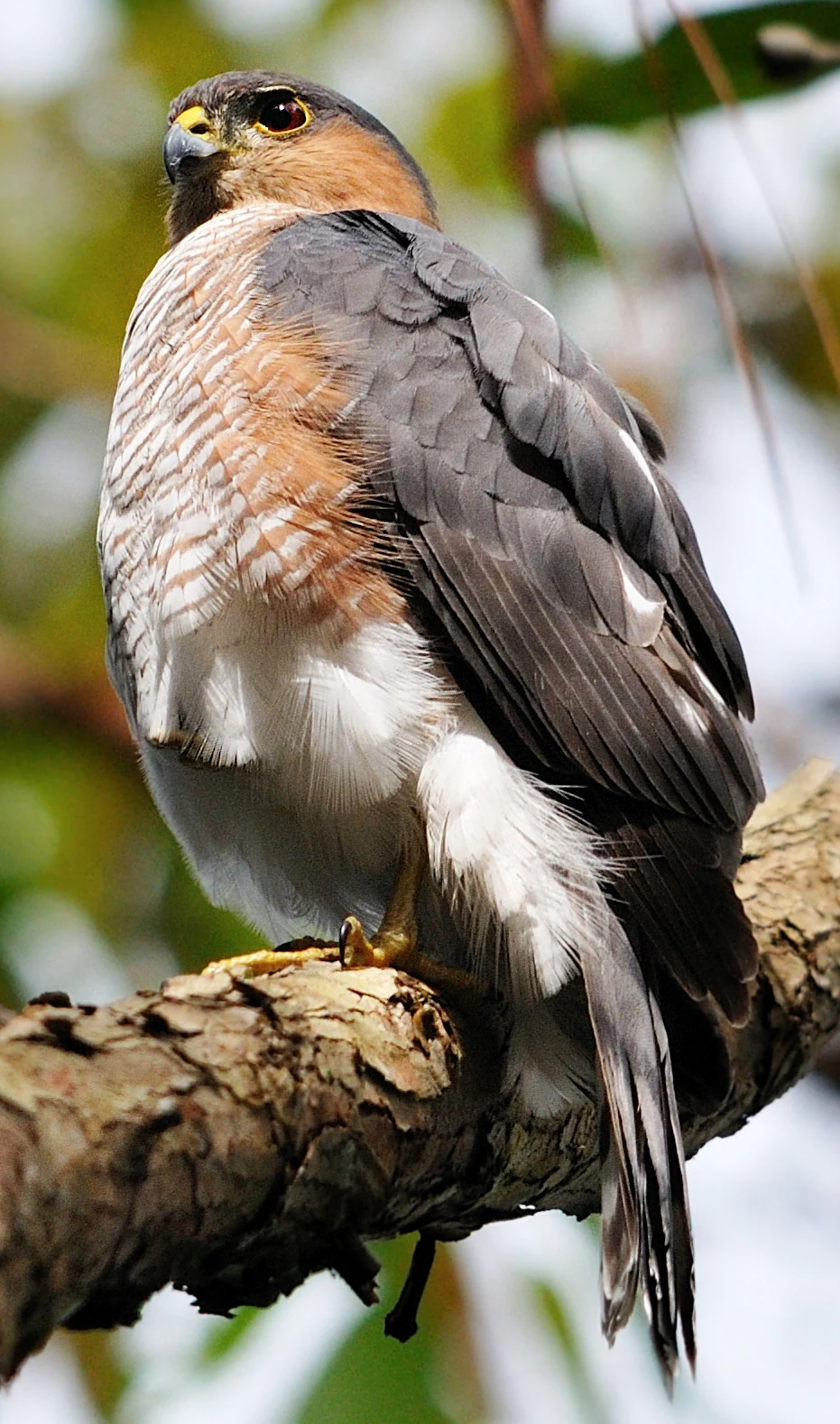
A close-up view of a Puerto Rican Sharp-shinned hawk with grey and white plumage perched on a rough tree branch.
A Puerto Rican Sharp-shinned hawk perched on a branch within the forest.

Los Tres Picachos State Forest history and protected-area timeline

Los Tres Picachos State Forest was officially proclaimed and designated on February 16, 1999, by executive order OE-199-10. The effort to protect this stretch of the Cordillera Central drew on the involvement of local residents, the municipal administrations of Ciales and Jayuya, and the environmental organization Guardianes de la Montaña.

The central purpose of the designation was to safeguard the ecological integrity of the forest terrain against the pressures of urban development, ensuring that the watershed functions and native habitats of the area would remain intact. Since its founding, the forest has become part of the broader network of protected natural areas in the Cordillera Central and has been formally recognized within the Important Bird Area system since 2007.

Los Tres Picachos State Forest landscape and geographic character

The terrain of Los Tres Picachos State Forest is shaped by its position within the Cordillera Central, Puerto Rico's principal mountain range. The defining feature of the landscape is the Los Tres Picachos mountain itself, which rises to about 3,176 feet (968 m) and is crowned by the three peaks that give the forest its name. Rugged ridges, forested slopes, and deeply incised river valleys characterize the broader topography.

Geologically, the forest lies in a transitional zone where karstic terrain meets areas of volcanic origin, producing a varied substrate that influences drainage, soil character, and vegetation patterns. The reserve sits along the divide between two major river basins, the Arecibo to the west and the Manatí to the east, both of which ultimately drain northward into the Atlantic Ocean. Headwater streams such as the Cialitos, Saliente, and Toro Negro rivers carve through the forested slopes.

A particularly scenic feature within the reserve is the Las Delicias Falls, a series of cascades along the Cialitos River that draws visitors willing to make the short scramble required to reach the main drop. Although the forest lacks developed infrastructure for recreation, the combination of mountain peaks, river valleys, and forested ridgelines defines its visual identity.

Los Tres Picachos State Forest ecosystems, habitats, and plant life

Los Tres Picachos State Forest is structured into three principal forest types arranged by elevation. Lower slopes support subtropical broadleaf forest, while middle elevations transition into a montane cloud forest where persistent moisture and mist sustain lush growth. At the highest elevations the forest gives way to tropical humid rainforest in the form of dwarf forest and Sierra palm stands adapted to constant cloud immersion.

Distinct ecological biomes layer across this elevational gradient. The dwarf forest occurs above roughly 1,090 meters, where trees are stunted and dense. Between approximately 850 and 1,090 meters, Sierra palm (Prestoea montana) forms characteristic stands. From about 700 to 850 meters, the tall candlewood or tabonuco (Dacryodes excelsa) dominates the canopy. In former agricultural lands, particularly areas once used for coffee production, secondary forest has reclaimed the landscape.

The forest is also rich in epiphytic life. Bromeliads and orchids cling to trunks and branches throughout the cloud forest zone, contributing to the dense, layered character of the vegetation. Native trees include the western cherry laurel (almendrón), the tabloncillo, the moca tree, granadillo, the Puerto Rican magnolia, and the nutget tree, alongside the invasive African tulip tree, which is largely confined to the secondary forest areas.

Los Tres Picachos State Forest wildlife and species highlights

The fauna of Los Tres Picachos State Forest reflects the high endemism typical of Puerto Rico's interior mountains. The reserve supports a particularly rich amphibian community, with multiple species of coqui frogs including the red-eyed coqui, grass coqui, whistling coqui, common coqui, cricket coqui, mountain coqui, and melodious coqui. These small, often nocturnal frogs are among the most emblematic sounds of the Puerto Rican forest.

Reptile life is similarly distinctive, with several endemic anoles such as the Puerto Rican crested anole, emerald anole, yellow-bearded anole, Krug's anole, dwarf anole, Puerto Rican anole, and Puerto Rican spotted anole. The forest also shelters the Puerto Rican boa, the island's largest native snake, and the Puerto Rican galliwasp.

Birds are a major draw. The endangered Puerto Rican sharp-shinned hawk is one of the forest's most important species and was highlighted by the reserve's inclusion in the Cordillera Central Important Bird Area in 2007. Other native birds include the Puerto Rican broad-winged hawk, Puerto Rican woodpecker, Puerto Rican bullfinch, Puerto Rican spindalis, Puerto Rican tody, and Puerto Rican vireo. Migratory species such as the ovenbird and Cape May warbler also pass through the area, while introduced species like the orange-cheeked waxbill and Venezuelan troupial are present.

Rivers within the forest host native fish such as the mountain mullet, American eel, violet goby, bigmouth sleeper, and sirajo goby. Mammal diversity includes at least one bat species of note, the Greater Antillean long-tongued bat, recorded in the reserve.

Los Tres Picachos State Forest conservation status and protection priorities

Los Tres Picachos State Forest is an important conservation area because it protects a representative cross-section of Puerto Rico's interior montane ecosystems. By holding substantial stands of subtropical broadleaf forest, cloud forest, and tropical humid rainforest in a single reserve, it preserves ecological gradients that would otherwise be vulnerable to fragmentation and development.

The reserve's inclusion within the Cordillera Central Important Bird Area in 2007 reflects its significance for avian conservation, particularly as habitat for the endangered Puerto Rican sharp-shinned hawk and a suite of endemic forest birds. Its watershed role is equally important. The forest anchors the Toro Negro River and contributes to the broader Arecibo and Manatí basins, providing the kind of hydrological stability that downstream communities and ecosystems depend upon.

By being situated in a transition zone between karstic and volcanic geology, the forest also serves as a living laboratory for understanding how Puerto Rico's diverse bedrock influences vegetation patterns, species distribution, and water resources. The DRNA's continued management of the area, in coordination with local communities and groups such as Guardianes de la Montaña, underscores the standing local commitment that led to its original protection in 1999.

Los Tres Picachos State Forest cultural meaning and human context

Los Tres Picachos State Forest carries meaningful local cultural significance for the communities of Ciales and Jayuya, whose residents played an active role in advocating for its protection in the late 1990s. The involvement of local municipal administrations and the community-based group Guardianes de la Montaña reflects a strong grassroots environmental identity in Puerto Rico's central mountains.

The forest landscape also retains traces of the region's agricultural history, particularly in the secondary forest patches that have grown back over former coffee plantations. This mosaic of recovering farmland and intact native forest links contemporary conservation to the traditional rural land use that shaped these mountains for generations. The nearby town of Coabey, in Jayuya, serves as a cultural and logistical gateway to the forest.

Top sights and standout views in Los Tres Picachos State Forest

The forest's three namesake peaks remain its most recognizable landmark, soaring above the surrounding Cordillera Central. Below them, the layered ecosystems of the reserve, from subtropical broadleaf forest to cloud forest to dwarf forest, create one of the most ecologically complete protected areas in central Puerto Rico.

Wildlife highlights include the endangered Puerto Rican sharp-shinned hawk, multiple endemic coquí frogs, and a dense community of endemic anoles. The Las Delicias Falls along the Cialitos River offer a memorable natural attraction, while the Toro Negro watershed underscores the forest's essential role in supplying fresh water to the island's interior rivers.

Best time to visit Los Tres Picachos State Forest

The forest's elevated location within the Cordillera Central means that cloud cover and rainfall patterns strongly influence the visitor experience. Conditions tend to be cooler and wetter at higher elevations, with the cloud forest and dwarf forest zones often immersed in mist. Periods of somewhat drier weather, when trails are more accessible and visibility from the peaks is clearer, are often the most rewarding for hiking and for appreciating the mountain scenery.

Because the forest lacks developed infrastructure, with no formal parking or sanitary services, visitors typically plan self-sufficient outings. The closest town is Coabey in Jayuya, and access is generally via Puerto Rico Highways PR-10 and PR-123 from Ponce. Hikers seeking cooler mountain air and the chance to experience the cloud forest atmosphere tend to favor the cooler, mistier conditions that characterize the higher elevations.

Monthly climate preview

Long-term monthly temperature and precipitation patterns recorded at representative park coordinates

Los Tres Picachos State Forest Climate Normals and Annual Temperature Rhythm

Representative coordinate records show average temperatures ranging from 23.6 to 26.78 degrees Celsius alongside recorded monthly precipitation measurements between 1.61 and 4.7 millimeters per day. Examining the full twelve-month climate profile reveals complete monthly temperature ranges and rainfall distributions across the protected forest.
Annual mean25 °C
24 °C27 °C
Jan24°
Feb24°
Mar24°
Apr25°
May26°
Jun26°
Jul27°
Aug27°
Sep27°
Oct26°
Nov25°
Dec24°
Warmest month
August

26.8 °C

Coolest month
January

23.6 °C

Wettest month
November

4.7 mm/day

Driest month
February

1.6 mm/day

Park location guide

Geography guide, regional context, and park location map for Los Tres Picachos State Forest

Los Tres Picachos State Forest park geography, regions, and map view in United States of America

Understand where Los Tres Picachos State Forest sits in United States of America through a broader geographic reading of the surrounding landscape, nearby location context, and its mapped position within the national park landscape.

How Los Tres Picachos State Forest fits into United States of America

The United States of America is a federal presidential republic and one of the world's largest countries by area and population. It consists of 50 states across a vast territory spanning multiple time zones, with its capital in Washington, D.C. and largest city in New York City. The nation has a diverse economy, influential political system, and significant cultural and military presence globally.

Wider geography shaping Los Tres Picachos State Forest in United States of America

The United States occupies a vast territory in North America, bordered by Canada to the north and Mexico to the south. The 48 contiguous states stretch from the Atlantic to the Pacific Ocean, while Alaska occupies the northwestern region and Hawaii is an archipelago in the Pacific. The country encompasses diverse terrain including the Rocky Mountains, Appalachian Mountains, Great Plains, and extensive river systems.

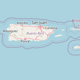
Map view of Los Tres Picachos State Forest

Use this park location map to pinpoint Los Tres Picachos State Forest in United States of America, understand its exact geographic position, and read its mapped placement within the surrounding landscape more clearly.

Pigeon | © OpenStreetMap contributors

Location context for Los Tres Picachos State Forest

Puerto Rico

Visualizing the rugged terrain, mountain peaks, and cloud forest ecosystems of Puerto Rico

Los Tres Picachos State Forest Photos, Scenery, and Protected Landscape Views

Examine detailed photographs of the volcanic ridges, forested slopes, and river valleys that define Los Tres Picachos State Forest. Visual research into these protected environments reveals the diverse topography and highland habitats of the Cordillera Central.

A close-up view of a Puerto Rican Sharp-shinned hawk with grey and white plumage perched on a rough tree branch.

A wide mountain landscape featuring lush green peaks under a blue sky with scattered clouds, with a dark structure visible in the bottom right corner.

Park atlas

Compare regional mountain reserves and connected upland protected areas across the Cordillera Central.

Parks Near Los Tres Picachos State Forest and Surrounding Protected Landscapes

Browse other parks near Los Tres Picachos State Forest to examine similar cloud forest reserves and volcanic mountain terrain. Comparing nearby protected areas reveals broader ecological patterns across the interior uplands of Puerto Rico.
Watercolor painting of a hilly, green landscape featuring rolling mountains in the distance and vegetation in the foreground.
State or regional parkUnited States of America
About 15 km away#1 closest

South

Cerrillos State Forest: Protected Subtropical Woodland and Reservoir Geography

Foothill landscapes and watershed features in Ponce, Puerto Rico

This protected area features a mix of tabonuco forest and water-based recreational terrain. Spanning the slopes of the Cordillera Central foothills, the forest encompasses the Cerrillos River and the man-made Lake Cerrillos reservoir, offering a distinct example of subtropical moist forest ecology within the United States commonwealth system.

Area
0.79 km²
Established
1996
Relief
Upland
Climate
Subtropical
Protected areaAdjuntas
About 16 km away#2 closest

West

Bosque del Pueblo: Protected Forest Geography and Cordillera Central Landscape

A mountain watershed and ecological corridor in Adjuntas

Bosque del Pueblo represents a key protected landscape within the central mountains of Puerto Rico. As a critical forest reserve located in Adjuntas, it preserves headwaters and supports rare bird populations, serving as a permanent ecological link between several major state forest units.

Area
2.987 km²
Established
1995
Relief
Mountain
Climate
Tropical
State or regional parkUnited States of America
About 22 km away#3 closest

Northwest

Río Abajo State Forest: Mapping the Karst Terrain and Protected Landscapes of Puerto Rico

Protected karst landscape and regional forest geography

Río Abajo State Forest serves as an essential example of Caribbean karst ecosystems, defined by its steep limestone mogotes, hidden ravines, and extensive sinkhole networks. Located in the northern karst belt of Puerto Rico, the forest provides deep insight into complex subterranean drainage patterns and serves as a primary hub for endangered species recovery within its uniquely broken, three-dimensional terrain.

Area
14.1 km²
Established
1943
Relief
Upland
Climate
Tropical
State or regional parkPuerto Rico
About 25 km away#4 closest

Southwest

Guilarte State Forest: Protected Mountain Ecosystems and Cordillera Central Geography

Highland conservation and mapped mountain terrain in central Puerto Rico

Guilarte State Forest represents a essential protected area in the Cordillera Central of Puerto Rico. The reserve encompasses steep altitudinal shifts, ranging from mid-slope palm forests to summit-level cloud forests. As a headwater region for major river basins, the forest is a focal point for understanding the island's mountainous geography and conservation priorities for endemic species.

Area
19.514 km²
Established
1935
Relief
Mountain
Climate
Tropical
A wide watercolor illustration showing a forest scene with trees in the foreground, a winding path or river, and green hills in the background.
Nature reservePuerto Rico
About 26 km away#5 closest

North

Cambalache Forest Reserve: A Detailed Look at Northern Puerto Rico Karst Geography

Protected karst landscape and forest mosaic

Focusing on the rugged limestone mogotes that define the Northern Karst Belt, Cambalache Forest Reserve serves as a vital protected area for endemic flora and fauna. This record provides geographic context on its low-elevation forest structure, the ecological significance of its varied microclimates, and its role as a persistent research site since the mid-twentieth century.

Established
1943
Relief
Upland
Access
Easy access
Scope
Terrestrial
Watercolor painting of a coastal dry forest scene with mangrove-like trees and hills in the background.
State or regional parkPuerto Rico
About 46 km away#6 closest

Southwest

Guánica State Forest: Mapped Geography and Protected Landscapes in Puerto Rico

A diverse Caribbean subtropical dry forest reserve spanning karst terrain and coastal habitats

Guánica State Forest serves as a primary protected natural area in southwestern Puerto Rico, defined by its arid subtropical climate and exceptional ecological diversity. This reserve incorporates a complex mosaic of ecosystems, including deciduous dry forest, mangrove channels, salt flats, and offshore keys. The landscape provides critical habitat for numerous endemic species while preserving the integrity of the Southern Karst geological zone and its surrounding maritime boundaries.

Area
39.97 km²
Established
1919
Relief
Lowland
Climate
Tropical
State or regional parkPuerto Rico
About 48 km away#7 closest

West

Maricao State Forest: A Detailed Map and Geographic Overview of Puerto Rico's Mountain Wilderness

Endemic-rich mountain forests and serpentinite terrain in the Cordillera Central

Maricao State Forest represents a vital protected landscape in the western Cordillera Central of Puerto Rico. This site features distinctive serpentinite geology, complex mountainous watersheds, and diverse endemic bird habitats. The forest serves as a primary geographic anchor along the Ruta Panorámica, providing clear insight into the rugged environmental character of the central island spine.

Area
43.72 km²
Established
1919
Relief
Mountain
Climate
Tropical
State or regional parkPuerto Rico
About 49 km away#8 closest

Southeast

Aguirre State Forest: Protected Coastal and Mangrove Geography in Southern Puerto Rico

Explore the estuarine terrain and tidal salt pond boundaries.

Aguirre State Forest encompasses a protected coastal mosaic of mangrove forests and salt-tolerant vegetation across the southern coast of Puerto Rico. This record outlines the forest's role as a primary node in the Jobos Bay estuarine system, characterized by low lying tidal channels and hypersaline flats that provide habitat for diverse avian and marine species within its protected borders.

Area
9.68 km²
Established
1918
Relief
Lowland
Climate
Tropical

Common questions about visiting, size, designation, and location context for Los Tres Picachos State Forest

Los Tres Picachos State Forest FAQs for park facts, access, geography, and protected area context

Find quick answers about Los Tres Picachos State Forest, including protected-area facts, park geography, trail and visitor context, and how the park fits into its surrounding country and regional landscape.
MoriAtlas Explorer

Continue Your Protected Areas Search Across the Global Atlas

Deepen your exploration by continuing the structured search for national parks and protected areas worldwide. Utilize the comprehensive filtering capabilities to compare different conservation landscapes and refine your understanding of global park geography. Discover more about the distribution and characteristics of protected natural areas.

Global natural geography