Mori Atlas logo
Wildlife reserveMackinac Wilderness

Analyzing glacial landforms, forest succession, and river-driven wetlands in a roadless wilderness

Mackinac Wilderness Wildlife Reserve: A Mapped Exploration of Michigan Protected Land Landscapes

The Mackinac Wilderness represents a significant protected enclave within Michigan's eastern Upper Peninsula. This 12,230-acre roadless reserve stands apart from the surrounding Hiawatha National Forest by allowing ecological processes to unfold without timber management. The landscape features a complex mosaic of postglacial moraines, sandy ridges, and dunes left behind by the Wisconsin glaciation. Centered around the Wild and Scenic Carp River, the unit supports an intricate network of wetlands and beaver ponds that define its character.

wilderness areaUpper PeninsulaHiawatha National Forestwild and scenic riverCarp Riverwetlands

Mackinac Wilderness

Wildlife reserve

Park overview

Structured park overview, official facts, and landscape profile for Mackinac Wilderness

Mackinac Wilderness park facts, protected area profile, and essential visitor context

Review the core facts for Mackinac Wilderness, including designation, size, terrain, visitor scale, habitats, and operating context in one park-focused overview.

About Mackinac Wilderness

The Mackinac Wilderness is a designated wilderness unit within the Hiawatha National Forest, one of several such areas set aside within the larger managed forest landscape of Michigan's Upper Peninsula. It sits in the eastern part of the peninsula in Mackinac County, between the northern shore of Lake Huron and the Soo region near Sault Ste. Marie, and is anchored by the Carp River, a designated National Wild and Scenic River that draws much of its ecological significance.

The unit functions as a refuge from the kinds of timber management practiced in the surrounding national forest. While most of the Hiawatha remains a working forest managed for pulpwood and other harvest, the Mackinac Wilderness was, as of the mid-2000s, managed jointly by the U.S. Forest Service and the Ojibwa tribe, with its interior left roadless. This makes the area unusually valuable as a living laboratory for understanding how northern forests recover from the combined legacy of nineteenth-century clear-cutting and repeated fire.

For visitors, the Mackinac Wilderness offers an experience that is intentionally low-facility. As of 2006 the unit contained no established footpaths, and people tended to explore via the Carp River corridor, its banks, and the narrow roadside strip along M-123 that borders the wilderness. That lean profile makes the area more attractive to those seeking solitude, water-based exploration, and unfiltered contact with the forest than to travelers looking for a developed trail network.

Quick facts and research context for Mackinac Wilderness

The Mackinac Wilderness lies in Mackinac County in Michigan's eastern Upper Peninsula, within the broader Hiawatha National Forest. It covers approximately 12,230 acres and is one of the smaller wilderness units nested inside that national forest.

The area is formally protected as an IUCN Category Ib wilderness area, meaning it is managed primarily to preserve its natural character and ecological processes. It is jointly administered by the U.S. Forest Service and the Ojibwa tribe, and access is from M-123, with the small community of Moran, Michigan, serving as the nearest town.

Protection and recognition

Documented terrestrial boundaries, management scope, and conservation recognition records.

Mackinac Wilderness Protection Status and Territorial Designation Details

Mackinac Wilderness maintains a documented terrestrial protection scope within its designated natural landscape boundaries. Official records organize administrative status and territorial classification parameters for structural geographic analysis.

Protection details

Protection scope
Terrestrial
Transboundary protection
No
Park context

Deeper park guide and search-rich context for Mackinac Wilderness

Mackinac Wilderness history, landscape, wildlife, and travel context

Explore Mackinac Wilderness through its history, landscape character, ecosystems, wildlife, conservation priorities, cultural context, and seasonal travel timing in a structured park guide built for atlas discovery and search intent.

Why Mackinac Wilderness stands out

The Mackinac Wilderness is best known for being one of the few roadless, unmanaged portions of the Hiawatha National Forest, offering a comparatively natural template of post-logging forest succession. It is also recognized for the nationally designated Wild and Scenic Carp River, which threads through wetlands and beaver ponds at the heart of the unit. Its landscape identity is defined by glacial features: postglacial moraines, sandy ridges, and dunes built up during the Wisconsin glaciation and later reshaped by wind and storm. The contrast between actively managed timberland outside its borders and a relatively undisturbed interior makes the wilderness a frequently cited example of how northern Michigan forests recover when left to natural processes.

Mackinac Wilderness history and protected-area timeline

Like the wider Hiawatha Forest, the Mackinac Wilderness carries a clear logging-era past. Beginning around 1880 and continuing until roughly 1910, the area was logged using methods typical of the era, with clear-cutting removing marketable timber and leaving large quantities of slash across the forest floor. That practice made severe forest fires almost inevitable, which in turn caused serious erosion and set the stage for the second-growth forest that defines the wilderness today.

The contrast between the original old-growth forest and the post-logging, post-fire second growth shaped nearly every aspect of the present landscape, from the mix of aspen and birch that now dominate the uplands, to the wetland patterns along the river, to the way beavers have come to engineer ponds across the terrain. Recognizing the unique value of allowing such a disturbed landscape to recover under natural conditions rather than active management led to the area's later designation as a wilderness unit.

As of the mid-2000s, administration of the Mackinac Wilderness was split between the U.S. Forest Service, the usual steward of national forest lands, and the Ojibwa tribe, whose presence ties the area to the longer Indigenous history of the eastern Upper Peninsula. Members of this community often refer to themselves as Chippewa, particularly in the eastern portion of the peninsula, and the joint management framework reflects the broader pattern of tribal involvement in the stewardship of public forested lands in the region.

Mackinac Wilderness landscape and geographic character

The terrain of the Mackinac Wilderness is dominated by glacial landforms associated with the Wisconsin glaciation. As the continental ice sheet retreated, it left behind a mosaic of postglacial moraines and sand dunes that continue to define the rolling topography of the unit. Stormy conditions during the glacial meltoff further reshaped these deposits, producing the sandy ridges and mounds that are now a signature element of the wilderness landscape.

Much of the elevation change in the wilderness comes from these sandy ridges, which are separated by networks of creeks and elongated, ribbon-shaped wetlands. The Carp River and its tributaries kink through the lowlands, and many of the higher ground pockets are laced together by beaver dams. The resulting beaver ponds are among the most recognizable and ecologically important water features in the wilderness.

Because much of the wilderness remains roadless and undeveloped, the landscape reads as a continuous, unfolding transition from dry, sandy ridges through beaver-flooded lowlands to the river itself. This gradient, repeated across the unit, gives the wilderness a varied scenic character despite its relatively modest size.

Mackinac Wilderness ecosystems, habitats, and plant life

Ecologically, the Mackinac Wilderness is best understood as a second-growth northern forest in active recovery from a century of logging, fire, and erosion. The dominant upland tree families are aspen and birch, both characteristic of post-disturbance forests across Michigan's Upper Peninsula, while the wetter areas near the Carp River support Northern whitecedar. Whitecedar populations are notably affected by browsing from the area's whitetail deer, which complicates regeneration in the most sensitive wetland fringes.

The wilderness's wetlands are central to its ecological identity. In addition to the Carp River itself, ribbon-shaped marshes and beaver-flooded flats create a network of standing and slow-moving water that supports a wide range of aquatic and semi-aquatic life. The Wild and Scenic designation of the Carp River reflects not just its scenic value but its role as a relatively intact natural trout stream, and the wilderness's protected status helps buffer the river's drainage from the more intensive forest management taking place in nearby parts of the Hiawatha.

Together, the sandy uplands, cedar swamps, beaver ponds, and river margins create a layered habitat mosaic that is relatively unusual within the otherwise actively managed Hiawatha National Forest. This patchwork of recovering forest types and water features is part of what makes the wilderness a useful reference site for understanding how northern Michigan ecosystems reassemble after large-scale disturbance.

Mackinac Wilderness wildlife and species highlights

Wildlife in the Mackinac Wilderness reflects the mix of wetland, river, and second-growth forest habitats that define the unit. The Carp River corridor and its associated wetlands support populations of wading and fish-eating birds, including the great blue heron, while larger wetland-associated species such as the sandhill crane nest in the wider marshy terrain of the wilderness. The river's status as a natural trout stream also makes it a notable freshwater resource for the area's animal life.

Beavers are among the most ecologically important mammals in the wilderness, acting as ecosystem engineers whose dams create and maintain many of the unit's ponds and flooded zones. Their influence conditions the surrounding habitat for fish, amphibians, waterfowl, and many smaller species, effectively shaping the day-to-day character of the wetlands. Whitetail deer are also widespread, and their browsing pressure affects tree regeneration in sensitive areas, especially Northern whitecedar stands along the river.

Predatory and scavenging birds such as the osprey add another layer to the wilderness's wildlife profile, fishing along the Carp River and patrolling the broader landscape. The combination of large wading birds, fish-eating raptors, waterfowl, beaver-modified wetlands, and a recovering northern forest gives the Mackinac Wilderness a wildlife community that feels closely tied to the rhythms of water and disturbance that shaped the land itself.

Mackinac Wilderness conservation status and protection priorities

Conservation significance is the very reason the Mackinac Wilderness exists. Within the much larger Hiawatha National Forest, which still functions as a working landscape with ongoing pulpwood harvest, the Mackinac Wilderness stands out as a deliberately roadless, minimally managed unit. This makes it a valuable reference area for understanding how ecosystems respond when active forest management is removed, and over time allows natural succession rather than silviculture to determine the structure of the forest.

A central element of its conservation value is the protection it provides to part of the Carp River's drainage, a National Wild and Scenic River that retains much of its natural character. By buffering the river and its associated wetlands from roads, intensive logging, and habitat fragmentation, the wilderness helps preserve water quality, shoreline integrity, and the conditions needed by native trout and a range of wetland-dependent species.

The beaver ponds and the whitecedar stands along the Carp illustrate the conservation challenges as well as the benefits. Beavers are essential to the system's hydrology, but deer browsing has been identified as a significant pressure on whitecedar regeneration. The joint management framework between the U.S. Forest Service and the Ojibwa tribe adds a further layer of cultural and institutional stewardship, linking long-term ecological protection with the Indigenous heritage of the region.

Mackinac Wilderness cultural meaning and human context

The Ojibwa, also commonly referred to as Chippewa, especially in the eastern Upper Peninsula, have a long-standing relationship with the lands that now make up the Mackinac Wilderness. Their presence in the region predates the logging era of the late nineteenth century by many generations and remains part of the ongoing social and cultural landscape of the area.

The joint stewardship arrangement between the U.S. Forest Service and the Ojibwa tribe is itself an expression of this cultural context. Rather than treating the wilderness purely as a federal reserve, the management framework acknowledges the tribe's historic and continuing connection to the land, integrating Indigenous stewardship into the day-to-day administration of the unit.

Naming also carries cultural weight: like nearby Mackinac Island, the wilderness is pronounced "Mack-in-aw," a pronunciation that is frequently missed in writing. Preserving the locally rooted pronunciation connects everyday use of the name to the longer history of the region, where Indigenous place names and identities continue to shape how the landscape is known and understood.

Top sights and standout views in Mackinac Wilderness

The Mackinac Wilderness offers a quiet but distinctive set of features that combine to define its character: a roadless core within an otherwise actively managed national forest, the Wild and Scenic Carp River threading through wetlands and beaver ponds, and a glacial terrain of moraines, sand dunes, and sandy ridges that gives the unit its rolling shape.

Its identity as a place of natural succession, where logging-era disturbance has been allowed to recover under its own dynamics, makes it an unusually informative stop for those interested in how northern forests reassemble themselves. Wildlife watching, fly-fishing on the Carp River, and contemplative travel through old logging country provide complementary ways to engage with this layered, water-shaped wilderness.

Best time to visit Mackinac Wilderness

The Mackinac Wilderness's character shifts with the seasons in ways typical of the eastern Upper Peninsula. Spring and early summer bring swelling water levels and the most active beaver and waterfowl presence along the Carp River and its associated wetlands, while also marking the nesting season for wading birds and raptors such as great blue herons, ospreys, and sandhill cranes.

Summer opens up the warmest window for wading, canoeing, or otherwise working along the Carp River corridor, and for exploring the network of beaver ponds in the lowlands. Autumn shifts the visual emphasis to the aspen and birch stands, which turn color across the sandy ridges. Winter brings heavy snow and cold, and the wilderness's lack of maintained trails and facilities means travel becomes more demanding, generally favoring experienced winter visitors prepared for snow conditions and remoteness.

Monthly climate preview

Long-term representative monthly temperature and precipitation patterns

Mackinac Wilderness Climate Normals and Annual Temperature Rhythm

Representative coordinate measurements reveal sustained sub-zero winter minimums alongside warm summer peaks with steady year-round precipitation. Reviewing the complete monthly profile provides detailed historical temperature averages and precipitation trends across the protected landscape.
Annual mean6 °C
-6 °C18 °C
Jan-6°
Feb-6°
Mar-3°
Apr
May
Jun14°
Jul18°
Aug18°
Sep15°
Oct
Nov
Dec-2°
Warmest month
August

18.3 °C

Coolest month
January

-6.3 °C

Wettest month
October

3.3 mm/day

Driest month
February

1.4 mm/day

Park location guide

Geography guide, regional context, and park location map for Mackinac Wilderness

Mackinac Wilderness park geography, regions, and map view in United States of America

Understand where Mackinac Wilderness sits in United States of America through a broader geographic reading of the surrounding landscape, nearby location context, and its mapped position within the national park landscape.

How Mackinac Wilderness fits into United States of America

The United States of America is a federal presidential republic and one of the world's largest countries by area and population. It consists of 50 states across a vast territory spanning multiple time zones, with its capital in Washington, D.C. and largest city in New York City. The nation has a diverse economy, influential political system, and significant cultural and military presence globally.

Wider geography shaping Mackinac Wilderness in United States of America

The United States occupies a vast territory in North America, bordered by Canada to the north and Mexico to the south. The 48 contiguous states stretch from the Atlantic to the Pacific Ocean, while Alaska occupies the northwestern region and Hawaii is an archipelago in the Pacific. The country encompasses diverse terrain including the Rocky Mountains, Appalachian Mountains, Great Plains, and extensive river systems.

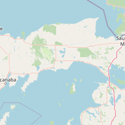
Map view of Mackinac Wilderness

Use this park location map to pinpoint Mackinac Wilderness in United States of America, understand its exact geographic position, and read its mapped placement within the surrounding landscape more clearly.

Pigeon | © OpenStreetMap contributors

Location context for Mackinac Wilderness

Michigan
Park atlas

Compare nearby national forests and protected terrain across the region

Parks Near Mackinac Wilderness and Surrounding Protected Landscapes

Visitors comparing Mackinac Wilderness can browse other protected areas within the surrounding regional geography. This regional comparison highlights connected forest ecosystems, glacial terrain features, and wild river corridors across northern Michigan.
A watercolor painting of a rolling, soft-toned landscape with a foreground of green forest and layers of hills receding into the distance.
Protected landscapeUpper Peninsula of Michigan
Park boundaries overlap#1 closest

West

Hiawatha National Forest: Geographic Overview and Protected Area Map of the Upper Peninsula

Coastal forest landscape and wilderness river corridors.

Hiawatha National Forest spans significant portions of the Upper Peninsula of Michigan, bridging the gap between northern hardwood forests and the boreal environments of the Great Lakes. This protected landscape encompasses extensive shorelines along Lake Superior, Lake Michigan, and Lake Huron, alongside six wilderness areas and five designated wild and scenic rivers.

Area
3,621.27 km²
Established
1931
IUCN
VI
Relief
Lowland
Wildlife reserveMichigan
8.2 km away#2 closest

Southeast

Horseshoe Bay Wilderness: A Detailed Geographic Overview of Michigan Protected Lands

Protected wetland habitat and Lake Huron coastal geography

Horseshoe Bay Wilderness represents a pristine 3,787-acre protected area located along the northwestern corner of Lake Huron in Michigan. Administered as part of the Hiawatha National Forest, this wilderness features an intricate post-glacial landscape of riparian wetlands, dense northern whitecedar stands, and quiet shallow waters that serve as vital spawning ground for local aquatic life.

Area
15.33 km²
Established
1987
IUCN
Ib
Relief
Lowland
A watercolor painting showing a winding river flowing through a lush, green valley with rolling mountains in the distance.
Wildlife reserveUnited States of America
About 28 km away#3 closest

Southeast

Round Island Wilderness: Geographic Overview of the Straits of Mackinac Wildlife Reserve

Coastal marsh, conifer forest, and hardwood interior terrain

Round Island Wilderness encompasses nearly all of a 378-acre island sanctuary, distinguished by its mature beech-maple hardwood interior and boreal-leaning conifer forests. This protected land remains an essential study of Great Lakes island ecology, standing as a quiet, undisturbed wilderness edge along the transit routes of the Michigan straits.

Area
1.53 km²
Relief
Lowland
Climate
Temperate
Access
Remote access
Marine protected areaMichigan
43 km away#4 closest

Southeast

Thunder Bay National Marine Sanctuary: Geography and Protected Maritime Landscape Context

Mapping underwater heritage in the Michigan Great Lakes region

Spanning 4,300 square miles of Lake Huron, Thunder Bay National Marine Sanctuary preserves a significant collection of shipwrecks within a glacially shaped freshwater terrain. This marine protected area offers a look at submerged geography ranging from shallow coastal bays to deep lake basins. It serves as a vital anchor for understanding maritime history and freshwater ecosystem stability across the Michigan shoreline.

Area
11,000 km²
Established
2000
Relief
Lowland
Climate
Temperate
A watercolor painting showing a rolling landscape with green fields, sandy dunes, and a purple mountain range in the distance.
Natural monumentAlger County
About 122 km away#5 closest

Northwest

Pictured Rocks National Lakeshore: Geographic Atlas of Cliffs and Shoreline Terrain

Protected landscape geography in Alger County, Michigan

Pictured Rocks National Lakeshore offers a deep look into the Great Lakes coastal geography. Explore the intersection of Cambrian-era sandstone cliffs, perched dune systems, and inland forested wilderness. This area provides a clear record of glacial and lake-driven erosion, featuring unique formations like Miners Castle and Chapel Rock across its extensive Lake Superior boundary.

Area
296.38 km²
Established
1966
IUCN
III
Visitors
953.1K annual
A soft watercolor painting showing green rolling hills, a calm body of water, and small clusters of pink flowers against a light, hazy background.
National parkMichigan
131 km away#6 closest

Southwest

Sleeping Bear Dunes National Lakeshore: Atlas, Maps, and Protected Landscape Geography

Great Lakes freshwater coast and glacial dune systems

Sleeping Bear Dunes National Lakeshore showcases the unique intersection of glacial geology and freshwater ecology. This protected area features massive dunes resting on ancient glacial deposits, backed by beech and maple forests. The geographic scope includes the vast shoreline of Lake Michigan, inland waters such as Glen Lake, and the distinct maritime history found across the remote North and South Manitou Islands.

Area
288.13 km²
Established
1970
IUCN
III
Visitors
1.5M annual
Wildlife reserveAlger County
159 km away#7 closest

West

Rock River Canyon Wilderness: Geographic Atlas and Protected Landscape Overview

Sandstone canyons and unmanaged forest terrain in Alger County

Covering 4,640 acres of the Upper Peninsula, Rock River Canyon Wilderness offers a rare look at natural forest processes. This protected area is defined by two 150-foot deep sandstone canyons, the flow of the Rock River, and the scenic Rock River Falls, serving as an ecological buffer within the broader Hiawatha National Forest landscape.

Area
18.8 km²
Established
1987
IUCN
Ib
Relief
Upland
Marine protected areaMichigan
About 167 km away#8 closest

Southeast

Thunder Bay National Marine Sanctuary and Underwater Preserve: Geography and Protected Area Atlas

Maritime heritage sites and glacial freshwater geography in Lake Huron, Michigan.

Situated along the rugged northeastern coast of Lake Huron, Thunder Bay National Marine Sanctuary and Underwater Preserve protects over two hundred shipwreck sites spanning nearly two centuries of maritime history. This marine protected area offers a unique intersection of submerged archaeological resources, shallow shoals, coastal marshes, and limestone bedrock, forming a vital freshwater ecosystem in the Great Lakes region of Michigan.

Area
11,000 km²
Established
2000
Relief
Lowland
Climate
Temperate

Common questions about visiting, size, designation, and location context for Mackinac Wilderness

Mackinac Wilderness FAQs for park facts, access, geography, and protected area context

Find quick answers about Mackinac Wilderness, including protected-area facts, park geography, trail and visitor context, and how the park fits into its surrounding country and regional landscape.
MoriAtlas Explorer

Continue Your Protected Areas Search Across the Global Atlas

Deepen your exploration by continuing the structured search for national parks and protected areas worldwide. Utilize the comprehensive filtering capabilities to compare different conservation landscapes and refine your understanding of global park geography. Discover more about the distribution and characteristics of protected natural areas.

Global natural geography