

Mori Atlas logo
National parkMagurski Park Narodowy

Geographic boundaries, forest mosaics, and ridge terrain in the Beskid Niski range

Magurski Park Narodowy: An Atlas Analysis of Transitional Carpathian Mountain Landscapes

Magurski Park Narodowy represents a vital ecological corridor within the Beskid Niski range of Podkarpackie Voivodeship, acting as a structural transition between the Western and Eastern Carpathians. This protected area covers a complex terrain of beech dominated woodlands, river-carved valleys, and the central Magura Wątkowska ridge. The park preserves old-growth forest remnants, peatlands, and diverse raptor habitats, offering a significant look at the physical geography and natural heritage of southeastern Poland.

Carpathiansbeech forestBeskid Niskimountain rangenational parktransitional forest zone
A colorful digital illustration of a waterfall cascading down rocky cliffs, surrounded by a coniferous forest, rolling green hills, and a small dirt trail in the foreground under a bright sky.

Magurski Park Narodowy

National park

Park overview

Structured park overview, official facts, and landscape profile for Magura National Park

Magura National Park park facts, protected area profile, and essential visitor context

Review the core facts for Magura National Park, including designation, size, terrain, visitor scale, habitats, and operating context in one park-focused overview.

About Magura National Park

Magura National Park protects a central section of the Beskid Niski, one of the quieter and more forested ranges of the Polish Carpathians. The park was created as part of a broader effort to safeguard large tracts of natural Carpathian forest and to maintain connectivity between protected landscapes that stretch across the mountains into Slovakia and Ukraine. Its territory lies in the upper Wisłoka river basin and follows the spine of the Magura Wątkowska range, including the peak of Wątkowa, which rises above the surrounding foothills.

Forests dominate the park. More than 90 percent of the area is wooded, with the landscape divided between a lower foothill zone dominated historically by planted Scots pine stands and an upper forest belt where natural beech communities prevail. These beech forests are mixed with fir in places and with sycamore maple, a tree that is uncommon elsewhere in the Carpatians. The combination of coniferous foothill remnants, semi-natural beech forests, small peatlands, and mountain streams gives the park a layered ecological character unusual within the Polish Carpathians.

The park's location at the meeting point of the Western Carpathians and the Eastern Carpathians has major ecological significance. This zone harbors plants and animals that are at the edges of their Carpathian ranges, and Magura serves as a stepping stone linking connected protected areas across borders. From the east the park meets the Jaśliski Landscape Park, while to the south, across the national border, it adjoins Slovakia's Východné Karpaty Protected Landscape Area. Together with other Carpathian reserves, Magura forms part of one of the larger continuous forest conservation networks in Central Europe.

In addition to its natural values, the park surrounds a region rich in cultural heritage. Villages within and near the park preserve wooden Greek Catholic churches, roadside crosses, and traces of traditional Carpathian Ruthenian and Lemko settlements. Educational trails, forestry roads, and marked hiking routes, including sections of the Main Beskid Trail and the long-distance European walking route E3, allow visitors to move through landscapes that combine forest scenery, river valleys, cultural monuments, and quiet mountain villages.

Quick facts and research context for Magura National Park

Magura National Park was created by regulation of the Polish Council of Ministers in November 1994 and began operations on January 1, 1995. It is administered from Krempna and sits at the junction of the Małopolskie and Podkarpackie voivodeships, with the majority of its area in Podkarpackie.

The park protects an important transitional forest zone between the Western Carpathians and the Eastern Carpathians within the Beskid Niski mountain range. It contains three strict protection areas: Magura Wątkowska, Kamień, and Zimna Woda, supplemented by the Kornuty rock reserve. To the east it borders the Jaśliski Landscape Park, and across the southern state border it connects with Slovakia's Východné Karpaty Protected Landscape Area.

Protection and recognition

Examining documented protected area designation, management scope, and international recognition records.

Magurski Park Narodowy Protection Status and Terrestrial Conservation Scope

Magurski Park Narodowy maintains a documented terrestrial protection scope within the regional conservation network. Structured conservation records outline official designation history, management frameworks, and international recognition details where available.

Protection details

Protection scope
Terrestrial
Transboundary protection
No
Buffer area
229.69 km²
Park context

Deeper park guide and search-rich context for Magura National Park

Magura National Park history, landscape, wildlife, and travel context

Explore Magura National Park through its history, landscape character, ecosystems, wildlife, conservation priorities, cultural context, and seasonal travel timing in a structured park guide built for atlas discovery and search intent.

Why Magura National Park stands out

Magura National Park is best known for protecting a unique transitional forest landscape between the Western and Eastern Carpathians. Beech-dominated woodlands on the higher slopes of the Magura Wątkowska ridge give way to mixed forests, meadows, and peatlands lower down, creating a layered mosaic of habitats across a relatively modest mountain range. The park also stands out in Poland for its remarkable raptor populations. It holds some of the country's densest breeding populations of common buzzard and Ural owl, and what is described as the highest density of lesser spotted eagle in Poland and one of the highest in Europe. This combination of Carpathian endemic-style forest cover and unusually rich birdlife makes Magura distinctive among Polish national parks.
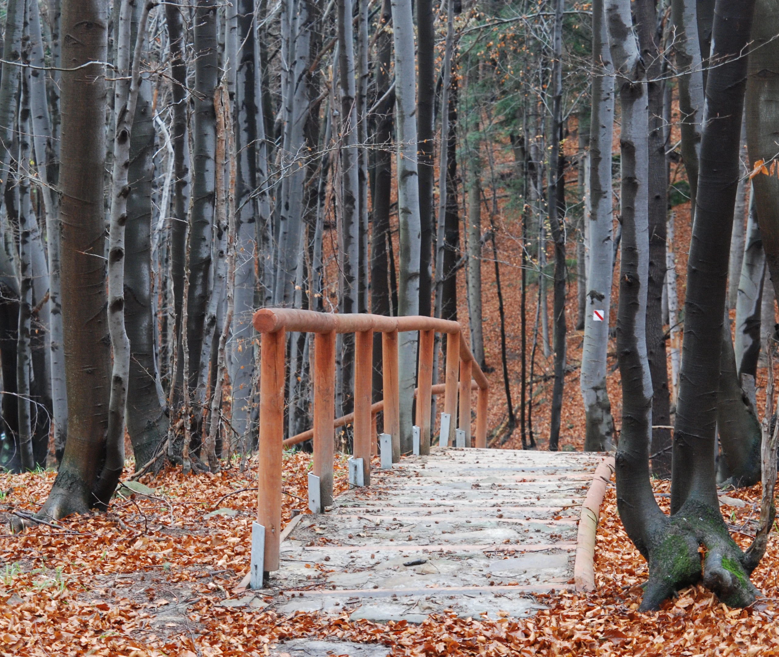
A small wooden footbridge with railings leads into a dense forest covered in fallen autumn leaves.
A wooden footbridge crossing a small stream in the wooded landscape of Magurski National Park.

Magura National Park history and protected-area timeline

The idea of establishing a national park in the Beskid Niski region emerged in the mid-1970s, but it took nearly two decades for the plans to translate into concrete legal protection. Magura National Park was formally created by regulation of the Council of Ministers of Poland on November 24, 1994, with operations beginning on January 1, 1995.

The park's initial area was slightly larger than its present extent. Difficulties with private landowners and the need to settle property boundaries led to reduction of the park to its current area of 194.39 square kilometers, while a buffer zone, or otulina, extends protection across an additional 229.69 square kilometers of surrounding landscape. Roughly 90 percent of the park lies within the Podkarpackie voivodeship and about 10 percent in the Małopolskie voivodeship.

The park's boundary remains unusually complex. Because private forest and agricultural land is interspersed with state-owned forest, the park's outline is highly indented, with numerous enclaves of municipal and private forest and farmland embedded within its territory. Successive directors have overseen consolidation of park protections, conservation planning, and expansion of education and ecotourism programs. The MPN Educational Center and Museum in Krempna reflects this growing public and interpretive role.

Magura National Park landscape and geographic character

The park occupies a moderately elevated section of the Beskid Niski, with rounded summit ridges, deep river valleys, and gently sloping foothills. The Magura Wątkowska ridge forms the park's central spine, anchored by the peak of Wątkowa, which at around 846 meters is the highest point in the park. Elevations descend to roughly 530 meters at the transition between the foothill and lower forest zones.

The terrain is shaped by the upper Wisłoka and its tributaries, which cut narrow forested valleys through the ridges. Small waterfalls, such as the Wodospad Magurski on the Magurka stream, and rock formations like the Diabli Kamień monument-shaped boulder near Folusz, add variety to an otherwise subdued mountain landscape. Across the southern state border the park connects with the Slovak Carpathians, forming part of the long ridgeline of the Beskidy.

Three strict protection reserves are particularly important to the park's landscape character: Magura Wątkowska, Kamień, and Zimna Woda. The Kornuty rock reserve sits just outside the strict core but within the broader park territory. These areas preserve old-growth and semi-natural forest stands, rocky outcrops, and characteristic relief features that together represent the most natural physical state of the park.
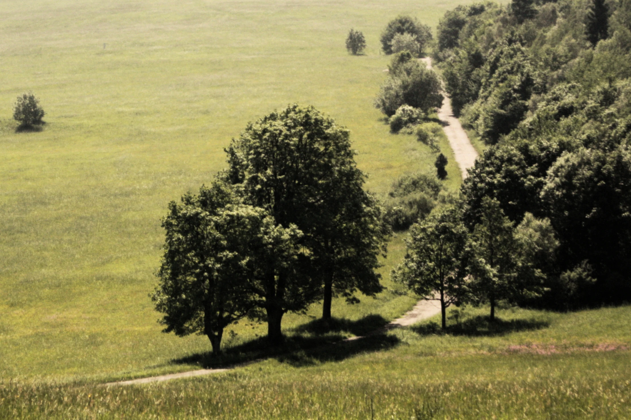
An elevated view looking down on a narrow gravel trail that follows the boundary between a dense forest and a large, open green meadow in a rolling landscape.
A rural trail winds along the edge of a forest and a wide grassy meadow in Magurski National Park.

Magura National Park ecosystems, habitats, and plant life

Magura National Park protects one of the most important forest complexes of the Polish Carpathians. Forests cover more than 90 percent of the park and are organized into two distinct altitudinal zones: a lower foothill zone largely shaped by planted Scots pine stands, meadows, pastures, and small peatlands, and an upper lower-regel zone dominated by natural beech forests intermixed with fir and rare sycamore maple.

The foothill zone, extending up to about 530 meters, contains both anthropogenic pine forests and ecologically valuable open habitats such as mountain meadows and peatlands. Above this elevation, the park's natural beech forests become increasingly dominant. The presence of sycamore maple in the beech forests is notable because this species is uncommon in other parts of the Polish Carpathians and helps underline the park's transitional character.

Nearly 800 plant species have been recorded in the park. Many are legally protected, including 59 species under strict protection and 12 listed in the Polish Red Book of Plants. The orchid flora is particularly significant, with around 20 orchid species documented in the park. Fungi are also rich: 463 species have been recorded, including 17 under strict protection, several of which are nationally rare morels, earthstars, and giant puffballs.
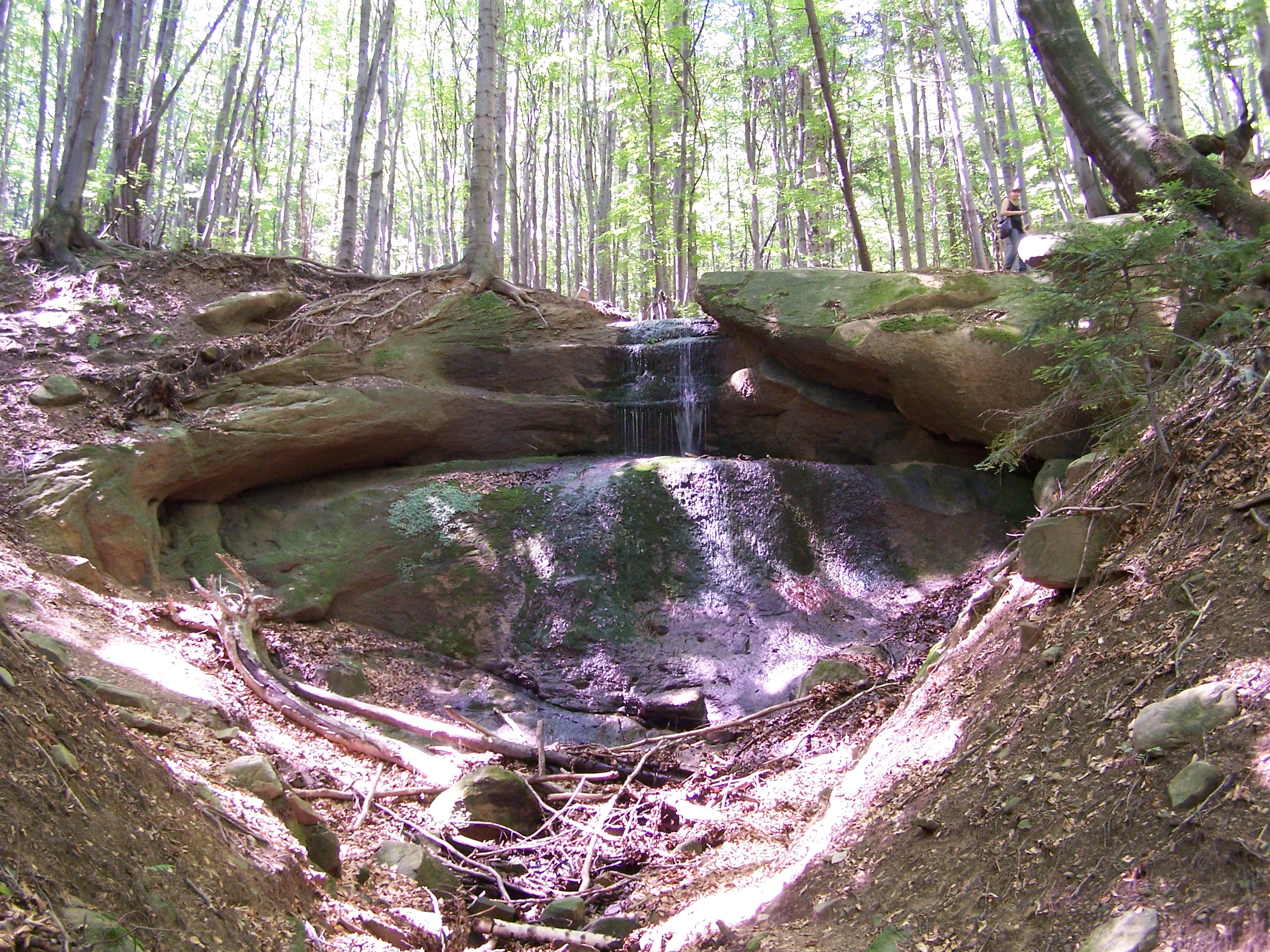
A small waterfall flowing over sandstone rock ledges surrounded by a lush forest in Magurski National Park.
The Magurski Waterfall, a natural feature found in the forest landscape of Magurski National Park.

Magura National Park wildlife and species highlights

Magura National Park supports a notably rich Carpathian fauna. Mammals recorded in the park total around 57 species, including 10 bat species. Large predators and ungulates of conservation interest are present, including the brown bear, gray wolf, Eurasian lynx, European wildcat, red deer, and Eurasian moose. Smaller mammals of conservation value include the European beaver, European otter, and muskrat.

Birds are the park's most striking wildlife feature, with roughly 117 breeding species. Raptors are exceptional: common buzzard reaches one of its highest breeding densities in Poland within the park, the lesser spotted eagle reaches what is documented as the highest density recorded in Poland and one of the highest in Europe, and the Ural owl similarly achieves a record Polish breeding density. Other notable raptors include the goshawk, black stork, golden eagle (in small numbers), and honey buzzard.

Reptiles, amphibians, and aquatic fauna round out the park's ecological character. Six reptile species and ten amphibian species have been recorded, including the Carpathian newt, alpine newt, fire salamander, common European adder, and yellow-bellied toad. The park's rivers and streams host 12 fish species, among which the brook trout, Common minnow, gudgeon, and spirlin are typical of clean Carpathian waters.

Magura National Park conservation status and protection priorities

Magura National Park plays a strategic conservation role within the Polish Carpathians. By protecting a large, continuous forest block at the transition between the Western and Eastern Carpathians, the park helps maintain ecological connectivity across a region that includes other reserves on both sides of the Polish-Slovak border. The strict protection areas within the park, Magura Wątkowska, Kamień, and Zimna Woda, together with the Kornuty rock reserve, safeguard reference sections of old-growth and semi-natural forest that are essential for long-term habitat integrity.

The park is also significant for species conservation. Habitats here support some of the densest populations of forest raptors in Poland, and the forest mosaic provides refuge for large carnivores that have disappeared from much of lowland Europe, including brown bear, wolf, and lynx. Wetland habitats, particularly small peatlands in the lower zones of the park, contribute to the preservation of specialized flora, including numerous orchids and species listed in the Polish Red Book of Plants.

Recognition of the park's conservation importance extends beyond Poland. Its integration into broader Carpathian ecological networks, including connection with the Slovak Východné Karpaty Protected Landscape Area and the Jaśliski Landscape Park to the east, makes it a meaningful component of transnational biodiversity protection in the Carpathians.

Magura National Park cultural meaning and human context

The area surrounding Magura National Park carries a strong Carpathian cultural identity shaped by Lemko and Carpathian Ruthenian historical presence, as well as Polish rural traditions. The region is known for its wooden Greek Catholic churches, several of which survive in villages such as Bartne, Chyrowa, Kwiaton, Skwirtne, Olchowiec, Polany, Krempna, Kotania, Świątkowa, and Pielgrzymka. These churches form an important architectural and religious heritage in the park's wider setting.

The cultural landscape includes roadside chapels, stone crosses, figural sculptures, and traces of pre-war villages that no longer exist as settlements, such as Świerzowa Ruska, which is now reached by a nature-cultural trail. War-era heritage is also present in the form of World War I cemeteries scattered across the park and World War II memorials, including a mass grave site at the Hałbów pass commemorating Jewish victims.

The park's educational and interpretive institutions, including the Magura National Park Educational Center and Museum in Krempna, together with nearby sites such as the Museum of the Oil Industry and Ethnography in Libusza and historic oil derricks at Kryg, reflect the region's broader heritage of oil extraction and rural Carpathian life. Traditional forestry, small-scale agriculture, and pastoral land use continue to shape the landscape around the protected core.

Top sights and standout views in Magura National Park

Magura National Park combines one of the most continuous Carpathian forest landscapes in Poland with exceptional raptor populations and a strong cross-border conservation role with Slovakia. Strict protection reserves, rare sycamore-beech forests, and Carpathian peatland fragments together form a park that is ecologically richer than its modest elevation range might suggest.

For visitors, the park offers forest hiking along sections of the Main Beskid Trail and the European long-distance path E3, dramatic natural features such as the Wodospad Magurski waterfall and the Diabli Kamień rock, and access to a cultural landscape of wooden churches, historic villages, and traditional Carpathian communities. The MPN Education Center in Krempna ties natural and cultural heritage together for anyone exploring the park's broader context.

Best time to visit Magura National Park

Like other parts of the lower Polish Carpathians, Magura National Park has two climatic zones within its territory: a moderately warm belt at lower elevations and a moderately cool belt higher up. Winters can bring heavy snow to the upper slopes, and strong local winds known as the Dukla and Rymanów winds are particularly felt in autumn and winter.

Late spring and early summer are typically attractive for viewing forest flora, including orchids and forest-floor plants such as bear's garlic and common toothwort. Late summer and early autumn are favorable for hiking in cooler air, while winter offers snowy forest scenery typical of low Carpathian landscapes. Visitors interested in birdlife benefit from spring and early summer, when many of the park's notable raptor species are easiest to observe in their breeding areas.

Monthly climate preview

Track long-term average monthly temperatures and precipitation rates measured at representative park coordinates.

Magurski Park Narodowy Climate Normals and Annual Temperature Patterns

Representative point measurements reveal the measured annual rhythm of average temperatures and precipitation rates across twelve distinct monthly intervals. Detailed climate records provide complete month-by-month temperature ranges and precipitation statistics for further study.
Annual mean7 °C
-5 °C18 °C
Jan-5°
Feb-3°
Mar
Apr
May13°
Jun16°
Jul18°
Aug18°
Sep13°
Oct
Nov
Dec-3°
Warmest month
July

18.4 °C

Coolest month
January

-4.7 °C

Wettest month
July

3.5 mm/day

Driest month
January

1.4 mm/day

Park location guide

Geography guide, regional context, and park location map for Magura National Park

Magura National Park park geography, regions, and map view in Poland

Understand where Magura National Park sits in Poland through a broader geographic reading of the surrounding landscape, nearby location context, and its mapped position within the national park landscape.

How Magura National Park fits into Poland

Poland, officially the Republic of Poland, is a Central European country spanning from the Baltic Sea in the north to the Carpathian Mountains in the south. It borders Germany, Czech Republic, Slovakia, Ukraine, Belarus, Lithuania, and Kaliningrad Oblast. The country has a temperate climate, diverse landscapes, and is known for its rich history, cultural heritage, and strong economic position within the EU.

Wider geography shaping Magura National Park in Poland

Poland occupies 312,696 km2 in Central Europe, extending from the Baltic Sea coast in the north to the Sudetes and Carpathian Mountains in the south. It borders Germany to the west, Czech Republic and Slovakia to the south, Ukraine and Belarus to the east, and Lithuania and Kaliningrad Oblast to the northeast. The landscape includes lowland plains, uplands, and mountain ranges.

Map view of Magura National Park

Use this park location map to pinpoint Magura National Park in Poland, understand its exact geographic position, and read its mapped placement within the surrounding landscape more clearly.

Pigeon | © OpenStreetMap contributors

Location context for Magura National Park

Malopolska VoivodeshipPodkarpackie Voivodeship
Natural feature types

View the Natural Feature Inventory for Magurski Park Narodowy

Examine the specific landforms and natural terrain that define the character of Magurski Park Narodowy. This structured resource provides geographic context for the mountain ridges, river systems, and protected forest areas, helping to visualize the physical composition of this significant Carpathian landscape through MoriAtlas.
Recorded earthquake history

View Historical Earthquake Records for Magurski Park Narodowy

Examine the seismic history of the region surrounding Magurski Park Narodowy through a structured catalogue of documented earthquake events. This MoriAtlas resource identifies historically recorded activity near the park boundaries to support comprehensive geographic discovery.

Magurski Park Narodowy Earthquake History

Catalogued events

4 events

Strongest magnitude

Magnitude 5

Most recent event

Oct 9, 2023

This history includes earthquakes recorded inside the park or within 50 km of its borders

Visual exploration of beech forests, mountain ridges, and protected Carpathian habitats.

Magurski Park Narodowy Photos, Landscapes, and Scenery Views

Visual documentation of Magurski Park Narodowy reveals the intricate terrain, dense beech woodlands, and river valleys defining the protected area. Examining national park photography provides clear insight into regional topography, transitional forest zones, and wildlife habitats across the Beskid Niski range.

A small wooden footbridge with railings leads into a dense forest covered in fallen autumn leaves.

A panoramic landscape view of a vast, golden-brown meadow in the foreground, stretching toward gentle, forested mountain slopes under a soft, overcast sky.

An elevated view looking down on a narrow gravel trail that follows the boundary between a dense forest and a large, open green meadow in a rolling landscape.

A small waterfall flowing over sandstone rock ledges surrounded by a lush forest in Magurski National Park.

Park atlas

Discover adjacent Carpathian mountain terrain and connected conservation areas

Parks Near Magurski Park Narodowy and Regional Protected Landscapes to Compare

Browsing nearby national parks helps place the forested ridges and transitional ecosystems of Magurski Park Narodowy into a wider regional context. Comparing these protected landscapes reveals shared mountain topography and continuous wildlife habitats across the border region.
Protected areaPodkarpackie Voivodeship
Park boundaries overlap#1 closest

East

Łysa Góra Protected Area: Mapping Carpathian Mountain Landscapes in Podkarpackie Voivodeship

Forested ridgeline terrain within the Low Beskids range

Spanning a series of summits including Grzywacka Góra and Dania, Łysa Góra encompasses vital Carpathian beech forest and protected mountain habitats. This Natura 2000 site functions as a key element of the Low Beskids mountain geography, featuring dense woodland cover that supports large carnivore populations and rare forest species across its protected ridge terrain.

Area
27.438 km²
Established
2009
Relief
Mountain
Climate
Temperate
Watercolor illustration showing a landscape with rolling hills, green trees, and distant mountains under a light sky
National parkSubcarpathian Voivodeship
Park boundaries overlap#2 closest

East

Magura National Park: Mapped Protected Landscape & Carpathian Geography Atlas

Explore unique sandstone formations and mapped natural terrain.

Magura National Park, located in the Subcarpathian Voivodeship of Poland, offers a rich focus for protected-area exploration and geographic discovery. This national park is distinguished by its dramatic sandstone rock formations, forested Carpathian ridges, and its ecological importance as a transitional zone. Users engaging with Magura National Park can examine its mapped boundaries, understand its specific landscape context, and appreciate its role within the broader regional geography.

Area
194.39 km²
Established
1995
IUCN
II
Visitors
40K annual
Protected areaPodkarpackie Voivodeship
Park boundaries overlap#3 closest

East

Ostoja Jaśliska Protected Area: Carpathian Forest Landscapes and Ecological Geography

Exploring Natura 2000 boundaries in Podkarpackie Voivodeship

The Ostoja Jaśliska protected area sits within the Beskid Niski range, offering a deep look into Carpathian beech forest communities and rare peatland habitats. The region holds nine distinct nature reserves and provides essential connectivity for apex predator populations. This geographic profile details the terrain and environmental importance of this expansive protected polygon in southeastern Poland.

Area
292.521 km²
Established
2009
Relief
Mountain
Climate
Temperate
Protected areaPodkarpackie Voivodeship
Park boundaries overlap#4 closest

North

Wisłoka z dopływami Protected Area: River Valley Landscape and Carpathian Foothills Atlas

Freshwater habitat mapping in southern Poland

Wisłoka z dopływami covers a long, ecologically rich segment of the Wisłoka river valley in the Carpathian foothills. This protected area connects diverse riparian, floodplain, and alluvial forests, serving as a critical habitat for six Annex II fish species and sixteen distinct riparian woodland types.

Area
26.51 km²
Established
2011
Relief
Mixed relief
Scope
Terrestrial
Protected areaPoland
0.2 km away#5 closest

Southeast

Źródliska Wisłoki Protected Area: Geography and Landscape Mapping in the Polish Carpathians

A detailed atlas exploration of spring mires and mountain meadows

Located in the Low Beskids of southern Poland, Źródliska Wisłoki preserves a rare ecological mosaic of spring-fed mires and semi-natural hay meadows. This protected area serves as a vital site for the headwaters of the Wisłoka river, offering deep insights into the structure and distribution of Carpathian mountain wetland habitats within the Sękowa commune.

Area
1.818 km²
Established
2011
Relief
Mountain
Scope
Terrestrial
Protected areaPodkarpackie Voivodeship
3.6 km away#6 closest

East

Trzciana Protected Area: A Geographic Atlas of the Low Beskids Forest Terrain

Ecological mapping of Carpathian ridge habitats in Podkarpackie.

Trzciana functions as an essential forest corridor within the Beskid Dukielski, offering a detailed look at Annex I habitat types including beech forests and undisturbed cave systems. The site provides a concentrated view of the natural mountain geography found in southern Poland, emphasizing the importance of protected woodland matrices and the specific ridge formations of the broader Low Beskids mesoregion.

Area
22.855 km²
Established
2009
Relief
Mountain
Climate
Temperate
Nature reservePodkarpackie Voivodeship
About 3.7 km away#7 closest

East

Rezerwat przyrody Modrzyna: Geography and Protected Forest Landscapes in Podkarpackie

A vital Carpathian nature reserve preserving rare Polish larch and old-growth mountain forest habitats

Rezerwat przyrody Modrzyna is a specialized floristic nature reserve nestled in the Beskid Niski range of Poland. Enclosed within the Jaśliska Landscape Park, it safeguards rare old-growth Polish larch and mixed fir forest. This protected area provides a unique window into the lower mountain forest ecosystems of the Western Carpathians, offering a clear view of the structural composition and biological importance of regional submontane landscapes.

Area
0.173 km²
Established
1953
Relief
Mountain
Climate
Temperate
Protected areaLesser Poland Voivodeship
6.6 km away#8 closest

Northwest

Ostoje Nietoperzy Powiatu Gorlickiego: Landscape and Protected Area Geography

A twelve-enclave forest network in the Lesser Poland foothills

Spanning roughly 2,825 hectares across Gorlice County, this protected area preserves representative stands of Central European beech and mixed slope forests. Through its unique multi-enclave design, the site acts as a key refuge for saproxylic beetles, Carpathian newts, and specialized chiropteran species that rely on the mosaic of mature timber and subterranean shelters in the Polish landscape.

Area
28.249 km²
Scope
Terrestrial
Forest
Mostly forested

Common questions about visiting, size, designation, and location context for Magura National Park

Magura National Park FAQs for park facts, access, geography, and protected area context

Find quick answers about Magura National Park, including protected-area facts, park geography, trail and visitor context, and how the park fits into its surrounding country and regional landscape.
MoriAtlas Explorer

Continue Your Protected Areas Search Across the Global Atlas

Deepen your exploration by continuing the structured search for national parks and protected areas worldwide. Utilize the comprehensive filtering capabilities to compare different conservation landscapes and refine your understanding of global park geography. Discover more about the distribution and characteristics of protected natural areas.

Global natural geography