

Mori Atlas logo
National parkMakira Natural Park

Trace the mapped boundaries, complex ridge terrain, and evergreen rainforest ecosystems characterizing this critical conservation stronghold.

Makira Natural Park: A Comprehensive Geographic Overview of Madagascar Largest Humid Forest Protected Landscape

Makira Natural Park stands as the largest contiguous block of low and mid altitude humid forest under formal protection in Madagascar. Spanning over 370,000 hectares across the northeastern regions of Analanjirofo, Sava, and Sofia, the park protects an essential watershed and a diverse mosaic of granitic, metamorphic, and ultramafic geological substrates. Its rugged terrain of steep ridges and deep valleys sustains a high level of plant endemism, supporting an internationally recognized refuge for moisture-dependent species.

humid forestrainforestlemursprimate conservationendemic speciesbirdwatching

Makira Natural Park

National park

Park overview

Structured park overview, official facts, and landscape profile for Makira Natural Park

Makira Natural Park park facts, protected area profile, and essential visitor context

Review the core facts for Makira Natural Park, including designation, size, terrain, visitor scale, habitats, and operating context in one park-focused overview.

About Makira Natural Park

Makira Natural Park represents one of the most ambitious and ecologically important protected area initiatives in Madagascar. Stretching across the rugged hills of the country's northeastern rainforest belt, the park protects around 372,470 hectares of lowland and mid-elevation humid forest, a habitat type that has been progressively reduced elsewhere in Madagascar by slash-and-burn agriculture, logging, and charcoal production. Together with its surrounding buffer zone of more than 350,000 hectares of community-managed forest, Makira forms the core of a forested landscape that is critical to the long-term survival of many of Madagascar's most threatened species.

The park's identity is shaped by its position within the Masoala-Makira-Antongil Bay (MaMaBay) landscape, one of the largest remaining tracts of eastern Malagasy rainforest. Its terrain is steep and dissected, with short elevational gradients and a complex geological mix of granitic, metamorphic, ultramafic, and alluvial substrates. These varied substrates, combined with extremely high and aseasonal rainfall, drive a remarkable diversity of forest types and support the exceptionally rich plant communities for which Makira is recognised. The area receives well over 3,500 mm of precipitation per year, with no marked dry season, and humidity that remains close to saturation throughout the year.

Ecologically, Makira is a global priority for primate conservation. It supports 17 lemur species, the highest documented lemur richness of any single protected area in Madagascar. Among these are three Critically Endangered species: the silky sifaka, the indri, and the black-and-white ruffed lemur, as well as the red ruffed lemur, whose entire global range lies within the Makira-Masoala region north of the Antainambalana River. The park also hosts a wide range of other endemic mammals, including the fossa, the falanouc, multiple tenrecs, and endemic nesomyid rodents, along with more than 120 bird species, many of them restricted-range endemics of Madagascar's eastern humid forests.

What distinguishes Makira further is its integration of conservation with rural development and climate policy. The park is the site of one of the world's first REDD+ projects, launched in 2005, and in 2013 it became the first government-owned REDD+ project in Africa to sell verified carbon credits on the voluntary carbon market. Community associations known as Communautés de Base (COBAs) play a central role in managing forest resources, running agroforestry programmes, and supporting non-timber forest products such as vanilla, cloves, cocoa, and raffia. This combination of biodiversity protection, carbon finance, and community-based stewardship makes Makira a model of integrated tropical conservation with global significance.

Quick facts and research context for Makira Natural Park

Makira Natural Park lies in northeastern Madagascar, inland from Antongil Bay and west of the coastal town of Maroantsetra, spanning three regions: Analanjirofo, Sava, and Sofia. Its strictly protected core covers roughly 372,470 hectares of humid forest, encircled by more than 350,000 hectares of community-managed forest.

The park was formally established on 19 June 2012 by Malagasy decree, following temporary protection granted in December 2005 and an earlier planning process launched in 2001 by the Ministry of Environment and Forests together with the Wildlife Conservation Society. It is classified as an IUCN Category II protected area, with delegated management to WCS, and is recognised as a Key Biodiversity Area, a Biodiversity Hotspot site, an Endemic Bird Area, and an Alliance for Zero Extinction site. With 17 recorded lemur species, including the silky sifaka, indri, and red ruffed lemur, Makira holds the highest documented lemur diversity of any protected area in Madagascar.

Protection and recognition

Documented terrestrial protection framework and management scope

Makira Natural Park Protection Status and Conservation Recognition

Makira Natural Park maintains a defined terrestrial protection scope within its regional conservation landscape. Official records outline the registered designation framework and management parameters associated with the protected area.

Protection details

Protection scope
Terrestrial
Transboundary protection
No
Buffer area
3,500 km²
Park context

Deeper park guide and search-rich context for Makira Natural Park

Makira Natural Park history, landscape, wildlife, and travel context

Explore Makira Natural Park through its history, landscape character, ecosystems, wildlife, conservation priorities, cultural context, and seasonal travel timing in a structured park guide built for atlas discovery and search intent.

Why Makira Natural Park stands out

Makira Natural Park is best known for being home to the highest recorded lemur diversity of any protected area in Madagascar, and for harbouring some of the rarest primates on Earth, most famously the silky sifaka, whose global range is largely restricted to the Makira-Anjanaharibe-Sud-Marojejy region. The park is equally renowned for its exceptional palm diversity, its large contiguous block of low and mid altitude evergreen humid forest, and its status as an Alliance for Zero Extinction site. It also stands out for its pioneering role in REDD+ forest carbon projects and for embedding community-based forest management into the design of one of Africa's most important tropical protected area landscapes.
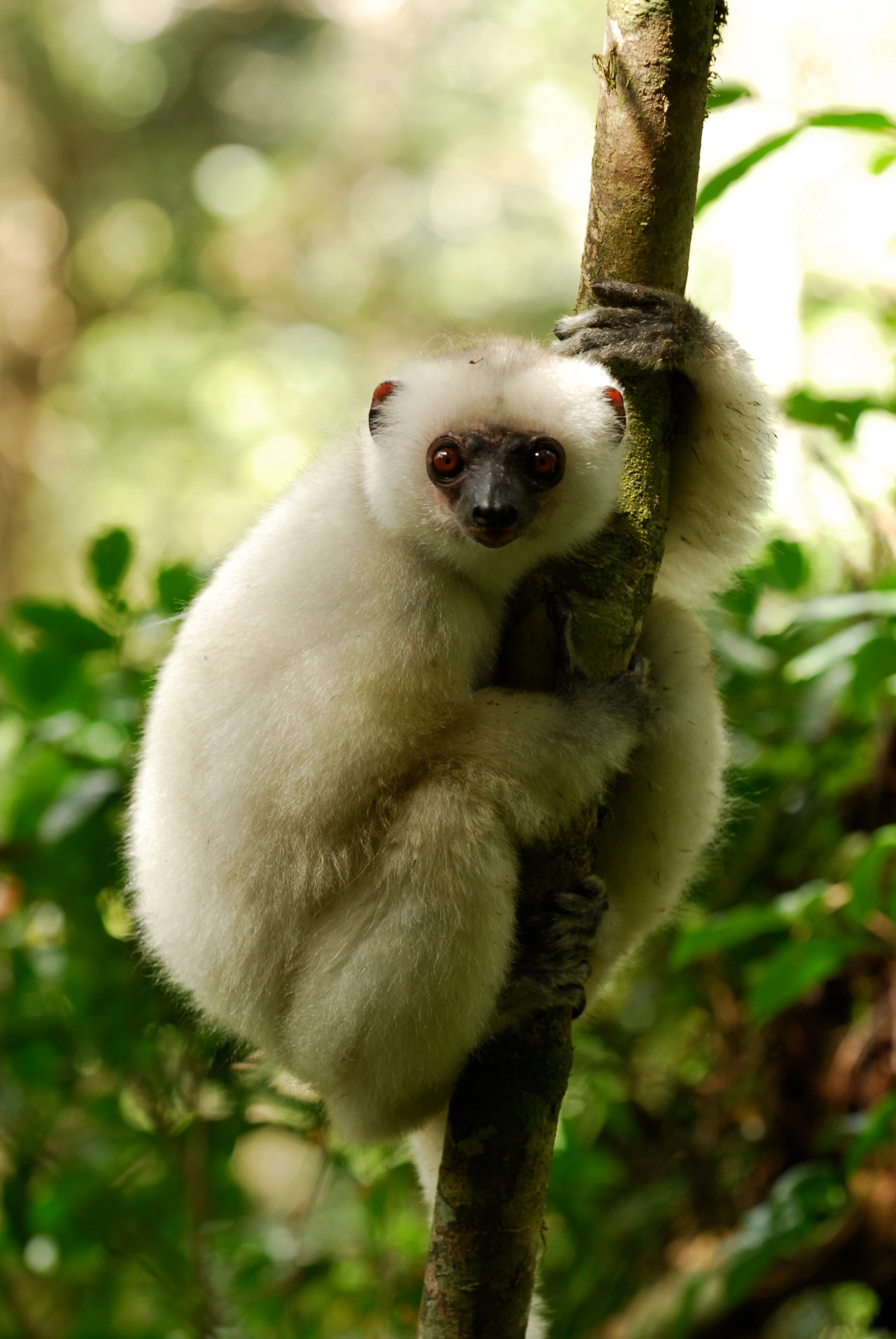
A white silky sifaka lemur clinging to a thin vertical tree branch in a lush forest environment.
A Silky sifaka, a rare and critically endangered lemur species found in the humid forests of Makira Natural Park.

Makira Natural Park history and protected-area timeline

The origins of Makira Natural Park lie in a 2001 initiative by the Malagasy Ministry of Environment and Forests, working in partnership with the Wildlife Conservation Society, which began a programme to identify and protect one of the last major blocks of humid forest in northeastern Madagascar. The Makira forests were recognised early on as a priority for conservation because they combined exceptional biodiversity, large forest cover, and the presence of multiple critically endangered primate species.

In December 2005, the area received temporary legal protection, which provided an initial legal framework for management and allowed the establishment of early conservation activities on the ground. This interim status supported several years of biodiversity surveys, community engagement, and the development of a forest carbon project, while formal gazettement was still being prepared.

The park was formally created on 19 June 2012 by Decree No. 2012-641, marking the culmination of more than a decade of planning, research, and negotiation among national authorities, conservation organisations, and local communities. Since gazettement, the protected area has been managed under a delegated management arrangement, and community-based forest management through the Gestion Contractualisée des Forêts process has become an integral part of its governance structure.

Makira Natural Park landscape and geographic character

Makira Natural Park lies in one of the most rugged and forested regions of northeastern Madagascar, set inland from Antongil Bay and forming part of the broader Masoala-Makira-Antongil Bay landscape. Its terrain is characterised by steep ridges, short elevational gradients, and a complex network of valleys carved by rivers descending toward the Bay of Antongil. Elevation changes are relatively modest but abrupt, producing a patchwork of microhabitats within short horizontal distances.

The geological substrate of the park is unusually varied for a humid forest reserve. Granitic, metamorphic, ultramafic, and alluvial substrates are all represented, and soils derived from these different rock types support distinct forest communities. Ultramafic substrates in particular are associated with specialised plant associations and are a focus of botanical interest. The combination of diverse geology and dissected topography contributes significantly to the park's exceptional floristic richness and to its high levels of plant endemism.

The climate reinforces the lush character of the landscape. Makira lies in one of the wettest parts of Madagascar, with mean annual rainfall exceeding 3,500 mm and sometimes approaching 5,900 mm, distributed throughout the year without a pronounced dry season. Humidity remains around 85 percent year-round, and even the driest months receive substantial rainfall. Persistent moisture, fog, and cloud cover sustain the evergreen canopy that defines the park's appearance and underpin its function as a refuge for moisture-dependent rainforest species.

Makira Natural Park ecosystems, habitats, and plant life

The forests of Makira belong to Madagascar's eastern humid forest biome and represent one of the largest remaining contiguous blocks of low and mid altitude evergreen rainforest in the country. Continuous canopy cover, minimal fragmentation at the core, and an exceptionally wet climate define the park's ecological character. Native tree families characteristic of the area include Sarcolaenaceae, Sapotaceae, Clusiaceae, Ebenaceae, Burseraceae, Phyllanthaceae, Anacardiaceae, and Pandanaceae, alongside prominent populations of native palms, including many Dypsis species, the iconic traveler's tree (Ravenala madagascariensis), and the raffia palm (Raphia farinifera), which is locally important for fibre and other uses.

Palm diversity is one of the defining ecological features of Makira, reflecting the broader importance of the MaMaBay landscape as a centre of palm endemism. Botanical inventories conducted in and around the park, combined with historical herbarium records, indicate that the flora is broadly representative of the eastern humid forest biome while also including a high proportion of locally endemic taxa. Researchers from institutions including the Missouri Botanical Garden and partner Malagasy organisations have highlighted Makira as a priority area for plant conservation.

The park also plays a significant role in regulating ecosystem services at the landscape scale. Watershed protection within Makira limits sediment delivery into Antongil Bay, helping to maintain downstream fisheries and coastal habitats. The intact forest cover contributes to climate regulation, freshwater provision, flood regulation, and coastal protection, linking the ecological integrity of the park with the well-being of communities both inside the buffer zone and along the coast.

Makira Natural Park wildlife and species highlights

Makira Natural Park is biologically best known for its lemur community, which is the most species-rich recorded in any Malagasy protected area. Seventeen lemur species have been documented in the park, spanning a cross-section of Madagascar's primate diversity. Three of these species, the silky sifaka, the indri, and a subspecies of black-and-white ruffed lemur, are classified as Critically Endangered, while the red ruffed lemur is notable because its entire global range is restricted to the Makira-Masoala region north of the Antainambalana River.

The silky sifaka is the park's most iconic species. One of the rarest primates in the world, it is largely confined to the Marojejy-Makira-Masoala landscape, and within Makira its southern distributional limit corresponds to the Antainambalana River. The park also supports the aye-aye and several other lemurs of conservation concern, providing important refugia in a country where primate habitats have been severely reduced.

Beyond primates, the park harbours more than 50 mammal species, including the fossa, Madagascar's largest endemic carnivore and a Vulnerable species on the IUCN Red List, the falanouc, and 13 species of tenrecs. Endemic rodents in the family Nesomyidae, including species of Eliurus and Nesomys, also occur. Birdlife is equally notable: more than 120 species have been recorded, with a strong representation of endemic taxa, including around ten species of vangas and high densities of Bernier's vanga, as well as threatened species such as the Madagascar serpent eagle and the Madagascar red owl. Reptile and amphibian communities include multiple endemic chameleons in the genera Brookesia, Calumma, and Furcifer, the spectacular leaf-tailed geckos of the genus Uroplatus, endemic Malagasy boas, and a rich assemblage of frogs in the genera Boophis, Mantidactylus, Gephyromantis, Mantella, Stumpffia, and Plethodontohyla.

Makira Natural Park conservation status and protection priorities

Makira Natural Park is internationally recognised as a site of global conservation significance, layered under multiple biodiversity prioritisation frameworks. It lies within the Madagascar and Indian Ocean Islands Biodiversity Hotspot, is recognised as a Key Biodiversity Area under the global KBA standard, falls within BirdLife International's Endemic Bird Area for East Malagasy wet forests, and has been identified as an Alliance for Zero Extinction site, with the silky sifaka and red ruffed lemur as trigger species. It is also part of WWF's Global 200 ecoregion framework and is included in Madagascar's network of Important Plant Areas.

The park meets all three biodiversity-related High Conservation Value categories defined under the HCV framework: significant concentrations of biodiversity values, landscape-level ecosystems supporting viable populations of species in natural patterns, and threatened or rare ecosystems. Hundreds of species occurring in the project zone are listed as Vulnerable, Endangered, or Critically Endangered on the IUCN Red List, with additional species listed under CITES appendices.

Beyond biodiversity, Makira is notable for being the location of one of the world's first REDD+ projects, a programme launched in January 2005 that aims to reduce emissions from deforestation and forest degradation. In 2013, the Makira Natural Park REDD+ Project became the first government-owned REDD+ project in Africa to sell verified carbon credits on the voluntary carbon market, achieving verification under the Verified Carbon Standard and the Climate, Community and Biodiversity Standards with triple Gold designation. A portion of carbon revenues is returned to surrounding communities to support infrastructure, education, health, sustainable agriculture, and alternative livelihoods, embedding the park within a broader climate and rural development agenda.

Makira Natural Park cultural meaning and human context

The human landscape around Makira Natural Park is shaped by the Betsimimaraka and Tsimihety peoples, two of the major ethnic groups of northeastern Madagascar, whose ancestors have long inhabited the forested hills and valleys of the MaMaBay region. Most residents are agriculturalists, cultivating subsistence crops such as rice and cassava alongside cash crops including vanilla, cloves, and cocoa. Raffia, harvested from the abundant raffia palms in the park's buffer zone, is another important source of income and material culture.

Roughly 90,000 people live in around 120 villages within or adjacent to the park's project area. Their relationship with the forest is intimate and multidimensional: hunting and gathering, wild honey collection, the use of botanical ethnomedicines, and even the consumption of certain clay and riparian earths (geophagia) form part of everyday life. Studies have shown that household diets depend in part on wild protein, and reducing reliance on bushmeat through improved agriculture, small livestock, and fisheries is one of the principal strategies used to align conservation goals with local food security.

Cultural identity in the Makira region blends traditional Malagasy religion with Christianity. Zanahary, the supreme being in Malagasy cosmology, is widely venerated, and even among the Christian population, a large majority continue to practise elements of traditional religion. This syncretic cultural context is reflected in how communities relate to the forest, treating it not only as a resource base but also as a landscape of ecological and spiritual significance.

Community-based forest management is central to the park's social architecture. More than 80 Communautés de Base have signed Gestion Contractualisée des Forêts contracts with the Government of Madagascar, transferring day-to-day management of more than 350,000 hectares of buffer forest to local associations. These COBAs administer agroforestry initiatives, value-chain support for non-timber forest products, and participatory ecological monitoring, making local communities central actors in the park's conservation model rather than simply beneficiaries or bystanders.

Top sights and standout views in Makira Natural Park

Makira Natural Park stands out as Madagascar's largest contiguous block of low and mid altitude humid forest under formal protection, and as the protected area with the highest documented lemur diversity in the country, including 17 species, three of them Critically Endangered. The silky sifaka, one of the rarest primates on Earth, finds one of its last strongholds here.

The park's profile is further defined by its exceptional palm diversity, its rich endemic bird fauna within BirdLife Endemic Bird Area 094, and its recognition as an Alliance for Zero Extinction site. Its ecosystem-service role is also significant: protection of the Makira watershed reduces sediment delivery into Antongil Bay, supporting coastal fisheries and downstream water quality.

Makira is unusually important in conservation policy as well. It hosted one of the world's first REDD+ projects and became the first government-owned REDD+ project in Africa to sell verified carbon credits, with community-based forest management at the heart of the model. The combination of high biodiversity value, pioneering forest carbon finance, and deep community involvement makes Makira a benchmark for integrated tropical conservation.

Best time to visit Makira Natural Park

Because Makira lies in one of the wettest parts of Madagascar and has no marked dry season, the park is technically accessible throughout the year, though conditions vary. Rainfall is heaviest in the main rainy months, when trails can become muddy and rivers harder to cross, while drier months tend to bring somewhat more comfortable hiking conditions and better visibility for primate and bird watching.

The relative dryness of the September-October period corresponds to a modest pause in the otherwise continuous rainfall pattern, and this window is often associated with more reliable access to forest trails and a slightly higher likelihood of lemur sightings, including the silky sifaka, whose white fur stands out against the green canopy. For visitors interested in birdwatching, the same months can be rewarding because reduced rainfall can make forest birding easier. For visitors prioritising landscape scenery and the most luxuriant forest display, the wetter months offer a more dramatic and lush experience, with mist-shrouded ridges, swollen rivers, and a fully active forest.
Monthly climate preview

Track representative monthly temperature averages and precipitation totals across the protected landscape

Makira Natural Park Climate Normals, Long-Term Temperature and Precipitation Rhythm

Long-term data records reveal measured shifts in average temperature and precipitation across twelve distinct monthly intervals at a representative coordinate within Makira Natural Park. Examining the complete monthly climate profile provides deeper context for analyzing annual weather patterns and environmental conditions throughout the protected area.
Annual mean21 °C
17 °C23 °C
Jan23°
Feb23°
Mar23°
Apr22°
May20°
Jun18°
Jul17°
Aug17°
Sep18°
Oct20°
Nov21°
Dec23°
Warmest month
February

23.1 °C

Coolest month
July

17.4 °C

Wettest month
January

13.3 mm/day

Driest month
October

2.7 mm/day

Park location guide

Geography guide, regional context, and park location map for Makira Natural Park

Makira Natural Park park geography, regions, and map view in Madagascar

Understand where Makira Natural Park sits in Madagascar through a broader geographic reading of the surrounding landscape, nearby location context, and its mapped position within the national park landscape.

How Makira Natural Park fits into Madagascar

Madagascar is an island nation in the Indian Ocean, positioned off the southeastern coast of Africa. As the world's fourth-largest island and second-largest island country, it stands out for its exceptional biodiversity, over 90% of its wildlife is endemic, making it one of 17 megadiverse countries. The population is approximately 32 million, with Antananarivo as both the capital and largest city.

Wider geography shaping Makira Natural Park in Madagascar

Madagascar lies in the Indian Ocean off the southeastern coast of Africa, separated from the mainland by the Mozambique Channel. The island is situated approximately 400 km from the African continent. As the world's fourth-largest island, it also includes numerous smaller peripheral islands.

Map view of Makira Natural Park

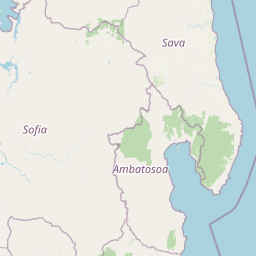
Use this park location map to pinpoint Makira Natural Park in Madagascar, understand its exact geographic position, and read its mapped placement within the surrounding landscape more clearly.

Pigeon | © OpenStreetMap contributors

Location context for Makira Natural Park

AnalanjirofoSavaSofia

Visualizing the evergreen rainforest terrain, steep ridges, and humid forest habitats of northeastern Madagascar

Makira Natural Park Photos and Landscape Scenery Exploration

Examine high-resolution imagery showcasing the rugged topography, dense evergreen canopy, and protected wilderness environments of Makira Natural Park. Visual documentation reveals the remote valley networks, microhabitats, and complex forest structures that sustain exceptional biodiversity across the region.

A white silky sifaka lemur clinging to a thin vertical tree branch in a lush forest environment.

Park atlas

Compare adjacent rainforest reserves and regional conservation landscapes

Parks Near Makira Natural Park and Regional Protected Areas

Continue browsing beyond Makira Natural Park to discover adjacent rainforest reserves and protected landscapes across northeastern Madagascar. Comparing regional parks provides deeper geographic context for the complex humid forest ecosystems of the region.
National parkAmbatosoa
About 26 km away#1 closest

East

Nosy Mangabe National Park: Atlas Overview of the Ambatosoa Island Forest Reserve

Coastal rainforests and protected lemur habitats in Antongil Bay.

Nosy Mangabe stands as a prominent protected island within the Ambatosoa region of Madagascar. The island is defined by its dense lowland rainforest, dramatic bay topography, and its essential role as a sanctuary for rare primates. This overview maps the park boundary and explores the terrain, historical maritime traces, and the connection between the island and the Masoala peninsula ecosystem.

Area
90.47 km²
Established
1965
IUCN
II
Visitors
3K annual
National parkSava Region
About 36 km away#2 closest

East

Masoala National Park: Explore Madagascar's Largest Protected Landscape and Marine Ecosystems

Discover the unique geographic features and rich biodiversity of this Sava Region national park.

Masoala National Park represents a critical protected landscape in Madagascar's Sava Region, spanning the vast Masoala Peninsula. The park's protected territory covers a remarkable range of ecosystems, including lowland and montane rainforests, coastal habitats, and extensive marine areas with coral reefs. Understanding the geographic scope and ecological diversity of Masoala National Park provides essential context for appreciating Madagascar's unique natural heritage and the importance of its conservation efforts.

Area
2,400 km²
Established
1997
IUCN
II
Visitors
3K annual
Wildlife reserveAnalanjirofo
About 76 km away#3 closest

Southwest

Réserve spéciale d'Ambatovaky: Protected Forest Landscape and Wildlife Reserve in Analanjirofo

Mapping rugged terrain and endemic forest ecosystems in northeastern Madagascar.

Réserve spéciale d'Ambatovaky spans a challenging, topographically complex area of northeastern Madagascar. This wildlife reserve consists of an unbroken canopy of humid lowland and hill forests, providing a critical refuge for rare raptors and diverse primate communities within the Analanjirofo region's mountainous terrain.

Area
600.5 km²
Established
1958
IUCN
IV
Relief
Upland
Wildlife reserveSava
About 80 km away#4 closest

North

Réserve spéciale d'Anjanaharibe-Sud: Geography and Protected Area Landscape Overview

Deep forest terrain and mountain ridges in the Sava region

Situated in northeastern Madagascar, Réserve spéciale d'Anjanaharibe-Sud encompasses dense evergreen forests and steep mountain terrain. This protected area serves as a significant conservation landscape for rare endemic species, providing a high-elevation habitat that climbs dramatically from 500 meters to peaks above 2,000 meters across the Sava region.

Area
182.56 km²
Established
1958
IUCN
IV
Relief
Mountain
National parkMadagascar
About 86 km away#5 closest

South

Mananara Nord National Park: National Park Geography and Protected Landscape Identity

Explore its mapped boundaries within Madagascar's diverse geography.

Mananara Nord National Park represents a vital protected landscape within Madagascar, offering users a direct entry point for exploring its specific geographic character. As a designated national park, it contributes significantly to the atlas of conservation lands on the island nation. This park provides a focused lens through which to examine regional geography and the mapped extent of protected natural areas, anchoring its identity within the broader context of Madagascar's unique ecological landscape.

Watercolor painting of a mountainous landscape with green vegetation, a body of water, and distant peaks under a light sky
National parkMadagascar
About 108 km away#6 closest

North

Marojejy National Park: A Protected National Park within Madagascar's Unique Geography

Mapped landscape context and regional protected area significance.

Marojejy National Park is a distinct protected area offering rich insights into Madagascar's natural geography. As a national park, its mapped boundaries define a significant landscape that contributes to the island nation's reputation as a biodiversity hotspot. This entry provides essential context for understanding Marojejy National Park's role within the country's protected lands and its value for structured geographic atlas exploration.

Area
555 km²
Established
1998
IUCN
II
Relief
Mountain
Wildlife reserveSofia region
About 167 km away#7 closest

Southwest

Tampoketsa Analamaitso Reserve: Wildlife Reserve and Protected Forest Geography in Sofia Region

Ecological transition zone featuring humid and dry forest biomes

Tampoketsa Analamaitso Reserve provides a protected sanctuary for northern Madagascar's primate fauna, defined by its rare combination of humid mid-altitude and dense dry forest ecosystems. Managed for habitat conservation, the reserve remains a remote wilderness area with intact forest cover that stretches across the Sofia region. Its geographic importance lies in the ecological gradient that links distinct upland and lowland vegetation types, offering a comprehensive look at the island's diverse natural terrain.

Area
171.5 km²
Established
1958
IUCN
IV
Relief
Upland
Nature reserveDiana
About 177 km away#8 closest

Northwest

Réserve naturelle intégrale de Tsaratanana: Highland Massif and Protected Mountain Terrain

High-altitude geography in the Diana region of northern Madagascar

Spanning tens of thousands of hectares, the Réserve naturelle intégrale de Tsaratanana protects the highest mountain terrain in Madagascar. The landscape is defined by the crystalline Vohibory massif, creating a complex topography of deep valleys and dramatic elevation gradients that support endemic primate habitats and montane forest ecosystems.

Area
486.22 km²
Established
1927
IUCN
Ia

Common questions about visiting, size, designation, and location context for Makira Natural Park

Makira Natural Park FAQs for park facts, access, geography, and protected area context

Find quick answers about Makira Natural Park, including protected-area facts, park geography, trail and visitor context, and how the park fits into its surrounding country and regional landscape.
MoriAtlas Explorer

Continue Your Protected Areas Search Across the Global Atlas

Deepen your exploration by continuing the structured search for national parks and protected areas worldwide. Utilize the comprehensive filtering capabilities to compare different conservation landscapes and refine your understanding of global park geography. Discover more about the distribution and characteristics of protected natural areas.

Global natural geography