
Mori Atlas logo
Nature reserveNaturschutzgebiet Malberg

Examining the phonolite summit and isolated blockfield terrain of this Westerwaldkreis nature reserve.

Naturschutzgebiet Malberg: A Protected Volcanic Landscape and Geological Landmark in Germany

Naturschutzgebiet Malberg serves as a distinctive geological focal point within the broader Westerwaldkreis region of Germany. This protected area preserves a 22-million-year-old phonolite volcanic dome that rises abruptly from the Montabaur Basin, contrasting with the softer surrounding terrain. The reserve encompasses a rugged summit blockfield characterized by crevices, small caves, and fragmented rock formations that define its unique habitat identity.

nature reservegeological sitephonolitevolcanic remnantinselbergblockfield
A flat-style digital illustration showing a dirt path leading toward a rounded, green, tree-covered hill under a soft sunset sky.

Naturschutzgebiet Malberg

Nature reserve

Park overview

Structured park overview, official facts, and landscape profile for Malberg Nature Reserve

Malberg Nature Reserve park facts, protected area profile, and essential visitor context

Review the core facts for Malberg Nature Reserve, including designation, size, terrain, visitor scale, habitats, and operating context in one park-focused overview.

About Malberg Nature Reserve

Malberg Nature Reserve sits in the heart of the Westerwald in Rhineland-Palatinate, protecting one of the most visually unusual landforms in the local landscape. The reserve takes its name from the Malberg, a prominent hill near Montabaur that rises conspicuously from the broad Montabaur Basin. From nearby settlements such as Staudt, the hill appears on the horizon as an isolated, steep-sided cone, distinct from the rolling ridges and plateaus that characterize most of the Westerwald.

The reserve covers roughly 96 hectares and lies within the cadastral areas of Ötzingen, Leuterod, and Moschheim in the Westerwaldkreis district. It was formally designated as a nature reserve on 19 January 1971 by the Bezirksregierung Koblenz, the regional government authority, building on an earlier protection notice of 6 December 1961. Internationally, the area is catalogued in the World Database on Protected Areas and is assigned IUCN Category IV, reflecting its management focus on specific habitats and species rather than on wilderness preservation at the broader ecosystem scale.

The protected significance of the site comes from the unique geological setting of the Malberg itself. While the surrounding region is shaped by ordinary sedimentary and weathered terrain, the Malberg is thought to have formed as a Staukuppe, an erosional remnant of an ancient volcanic intrusion. This origin produced a body of phonolite, sometimes described alternatively as phonolithic trachyte, dating back approximately 22 million years. Because this rock is harder and more resistant than the surrounding geology, the hill has persisted as a sharp rise above the basin, capped by a blockfield of weathered boulders and fractured outcrops.

The summit environment includes deep crevices, small natural caves, and accumulations of fallen rock. These features create microhabitats for specialized flora and fauna, and they give the reserve its distinct character among the many forested and agricultural landscapes of the Westerwald. The combination of isolated hill, unusual rocky substrate, and protected habitat is what makes Malberg a small but well-defined conservation area in Rhineland-Palatinate.

Quick facts and research context for Malberg Nature Reserve

Malberg Nature Reserve lies in the Westerwaldkreis district of Rhineland-Palatinate in western Germany, within the broader Westerwald low mountain range. It was officially designated as a nature reserve on 19 January 1971 by the Koblenz district government, following an earlier protection order dated 6 December 1961.

The protected area encompasses about 96 hectares and spans the municipal areas of Ötzingen, Leuterod, and Moschheim. It is internationally recorded in the World Database on Protected Areas under WDPA ID 82138. Geologically, the reserve is anchored on a phonolite inselberg believed to have formed as a volcanic cupola, with rock exposures that include crevices, small caves, and weathered blocks near the summit.

Protection and recognition

Examine terrestrial protected area designations and management scope data.

Naturschutzgebiet Malberg Protection Status and Recognition Records

Terrestrial protection status and designation details for Naturschutzgebiet Malberg provide a clear baseline of recorded administrative measures. Documented management scope facts support reliable evaluation of conservation frameworks and official protected area registries.

Protection details

Protection scope
Terrestrial
Transboundary protection
No
WDPA ID
82138
Park context

Deeper park guide and search-rich context for Malberg Nature Reserve

Malberg Nature Reserve history, landscape, wildlife, and travel context

Explore Malberg Nature Reserve through its history, landscape character, ecosystems, wildlife, conservation priorities, cultural context, and seasonal travel timing in a structured park guide built for atlas discovery and search intent.

Why Malberg Nature Reserve stands out

Malberg Nature Reserve is best known for its unusual geology. The Malberg itself is thought to be a Staukuppe, a type of volcanic dome or cupola, that stands out from the Montabaur Basin like a molehill in a plain. The summit exposes around 22-million-year-old phonolite, a rare volcanic rock in the region, that has eroded into a blockfield riddled with crevices, small caves, and rock falls. This combination of a lone, hard-rock summit with a structured rocky habitat is the defining feature of the reserve, and the reason it earns protected status within an otherwise typical Westerwald landscape.
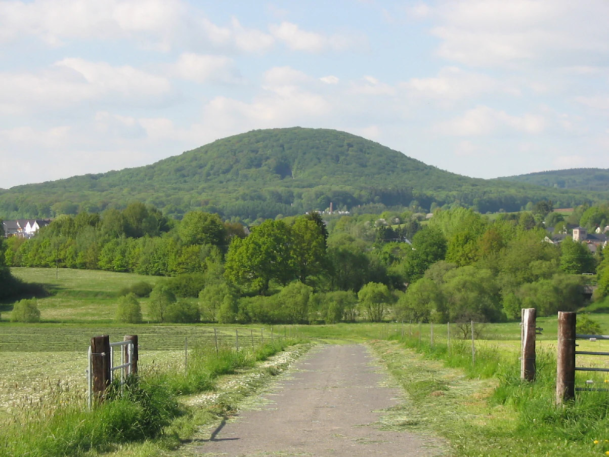
A green, forested hill rises in the distance behind a rural foreground with a dirt path leading through fields.
View of the Malberg hill rising above the surrounding rural landscape.

Malberg Nature Reserve history and protected-area timeline

The Malberg was placed under initial protection on 6 December 1961, marking the first formal recognition of its natural significance. This earlier protective order laid the groundwork for stronger legal recognition of the area.

On 19 January 1971, the Bezirksregierung Koblenz, the regional administrative authority for the Koblenz district at the time, formally designated the Malberg as a Naturschutzgebiet, or nature reserve. This designation established the modern boundaries and the legal framework under which the roughly 96-hectare area continues to be managed today.

Malberg Nature Reserve landscape and geographic character

The defining landscape feature of Malberg Nature Reserve is a single, isolated hill that breaks the gentle skyline of the Montabaur Basin. Unlike the surrounding Westerwald terrain, which consists of broad ridges and rounded low-mountain forms, the Malberg rises with a sudden, almost conical profile that has been compared visually to a molehill emerging from a plain.

Geologically, this prominence is the result of underlying phonolite, a hard, dense volcanic rock roughly 22 million years old, with some sources describing the rock as phonolithic trachyte. The contrast between this resistant rock and the softer surrounding geology is the reason the hill has survived as a distinctive feature while the rest of the basin has been worn down.

At the summit, the phonolite has weathered into a blockfield known in German as a Felsenmeer. This rugged zone is broken up by numerous crevices, small rock caves, and accumulations of fallen blocks from past rock slides. The combination of steep upper slopes, exposed rock surfaces, and rocky microtopography gives the reserve a landscape character quite unlike the forested and agricultural Westerwald hills that surround it.

Malberg Nature Reserve ecosystems, habitats, and plant life

The ecological value of Malberg Nature Reserve is closely tied to its rocky summit environment. The blockfield of phonolite boulders is broken by crevices, shallow caves, and uneven rock surfaces, producing a mosaic of microhabitats that are uncommon in the surrounding lowlands. These rocky features support specialized plant communities adapted to thin soils and increased exposure, as well as sheltered spaces for crevice-dwelling fauna.

The lower slopes of the Malberg transition into mixed woodland and farmland typical of the Westerwald, with habitats that complement the rocky summit zone. Together, the rocky outcrops, slope forests, and adjacent land uses within the roughly 96-hectare protected area form the habitat framework that the reserve is designed to conserve.

As a formally designated nature reserve in Rhineland-Palatinate, Malberg is part of the regional network of protected areas managed by the state. Its IUCN Category IV status emphasizes targeted habitat and species management, recognizing that the rocky inselberg environment requires active conservation attention to maintain its distinctive character.

Malberg Nature Reserve wildlife and species highlights

The wildlife profile of Malberg Nature Reserve is shaped primarily by the rocky structures of the summit. The crevices, small caves, and boulder accumulations of the phonolite blockfield offer shelter for a range of species adapted to rugged, stony terrain, including rock-dwelling invertebrates and small vertebrates that use the cracks and cavities for cover and nesting.

Below the rocky summit, the slopes support woodland and edge habitats typical of the Westerwald. These transitional areas host the usual community of forest birds, small mammals, and woodland insects associated with mixed central German upland forests. The mosaic of rock, woodland, and adjacent open land within the reserve provides a varied environment for species that benefit from the interface between these habitats.

The reserve's enduring conservation interest lies less in the presence of single charismatic species and more in the unusual combination of a rocky inselberg habitat embedded within a broader Westerwald landscape, an arrangement that supports species communities not typically found elsewhere in the district.

Malberg Nature Reserve conservation status and protection priorities

Malberg Nature Reserve was established to protect the unusual geological and ecological character of the Malberg hill, a phonolite inselberg in the otherwise sedimentary Montabaur Basin. Its conservation value rests on the fact that the rocky summit environment, with its crevices, small caves, and blockfield structure, is a rare and localized habitat type within the Westerwald region.

Designated as a Naturschutzgebiet on 19 January 1971 by the Bezirksregierung Koblenz, following earlier protective measures from 1961, the reserve is managed under the legal framework of Rhineland-Palatinate nature conservation law. Its IUCN Category IV classification identifies it as a Habitat/Species Management Area, meaning conservation management focuses on maintaining specific habitats and the species associated with them rather than designating the area as a wilderness or strict nature reserve.

The roughly 96-hectare reserve plays a role in the broader network of protected areas in the Westerwaldkreis, alongside other nature reserves that protect forests, rivers, heathlands, and ponds across the district. Its main contribution to regional conservation is the preservation of a distinct volcanic geological feature and the small-scale rocky habitats that depend on it.

Top sights and standout views in Malberg Nature Reserve

The highlights of Malberg Nature Reserve center on a single striking geological feature: the Malberg itself, a phonolite hill that rises abruptly from the Montabaur Basin near Montabaur. Unlike most Westerwald hills, the Malberg is thought to have formed as a volcanic cupola, and its summit exposes around 22-million-year-old phonolite in a dramatic blockfield of crevices, small caves, and rock falls.

The reserve's compact 96-hectare footprint, spanning Ötzingen, Leuterod, and Moschheim, makes it a focused site rather than an extensive wilderness area. Its IUCN Category IV status reflects the specific management approach applied to its unusual rocky habitat, and its place within the broader network of Westerwaldkreis nature reserves connects it to the wider effort to protect distinct habitats in Rhineland-Palatinate.

Monthly climate preview

Long-term temperature ranges and monthly precipitation averages for this protected terrain

Naturschutzgebiet Malberg Climate Normals and Annual Weather Patterns

Historical climate data from 1991 to 2000 reveals measured monthly temperature swings and precipitation averages across the representative coordinate of Naturschutzgebiet Malberg. Examining the full twelve-month profile provides deeper insight into long-term environmental patterns for this protected area.
Annual mean9 °C
0 °C19 °C
Jan
Feb
Mar
Apr
May12°
Jun16°
Jul19°
Aug18°
Sep14°
Oct
Nov
Dec
Warmest month
July

18.5 °C

Coolest month
January

-0.4 °C

Wettest month
December

2.5 mm/day

Driest month
April

1.6 mm/day

Park location guide

Geography guide, regional context, and park location map for Malberg Nature Reserve

Malberg Nature Reserve park geography, regions, and map view in Germany

Understand where Malberg Nature Reserve sits in Germany through a broader geographic reading of the surrounding landscape, nearby location context, and its mapped position within the national park landscape.

How Malberg Nature Reserve fits into Germany

Germany is a federal republic in Western and Central Europe with a population of over 83 million across sixteen constituent states. It is Europe's largest economy by nominal GDP and a major global exporter and importer. The capital is Berlin, and the country borders Denmark, Poland, Czech Republic, Austria, Switzerland, France, Luxembourg, Belgium, and the Netherlands.

Wider geography shaping Malberg Nature Reserve in Germany

Germany is located in Western and Central Europe, spanning 357,022 km². It borders Denmark to the north, Poland and the Czech Republic to the east, Austria and Switzerland to the south, and France, Luxembourg, Belgium, and the Netherlands to the west. The country has coastlines on the Baltic Sea and North Sea to the north, with the Alps located in the southern region.

Map view of Malberg Nature Reserve

Use this park location map to pinpoint Malberg Nature Reserve in Germany, understand its exact geographic position, and read its mapped placement within the surrounding landscape more clearly.

Pigeon | © OpenStreetMap contributors

Location context for Malberg Nature Reserve

Rheinland-PfalzWesterwaldkreis

Visualizing the volcanic rock formations, summit blockfields, and protected terrain of the Westerwald region.

Naturschutzgebiet Malberg Photos and Landscape Scenery

Visual documentation captures the striking volcanic dome and rocky summit blockfield that define the topography of Naturschutzgebiet Malberg. Examining field photographs and terrain imagery clarifies the geological features that distinguish the reserve from surrounding lowlands.

A green, forested hill rises in the distance behind a rural foreground with a dirt path leading through fields.

Park atlas

Compare regional protected areas and volcanic terrain across the Westerwald

Explore Parks Near Naturschutzgebiet Malberg and Surrounding Protected Landscapes

Continue exploring protected natural areas by comparing Naturschutzgebiet Malberg with other regional reserves. Discovering adjacent parks provides broader geographic context for the unique volcanic geology of the Westerwald region.
A horizontal watercolor painting showing a calm lake or pond with grassy banks, small trees, and soft hills in the background.
Protected areaGermany
About 9.2 km away#1 closest

North

Brinkenweiher Protected Area and Westerwald Lake District Geography

Historic wetland habitat in Rhineland-Palatinate

Brinkenweiher serves as a significant example of a seventeenth-century Waldweiher, shaped by human engineering to dam the Holzbach headwaters. Today, the site functions as a protected nature reserve, offering a varied landscape of shadowed forest fringes, marshy wetlands, and open meadows that support a coherent wetland ecosystem within the broader Westerwälder Seenplatte.

Area
0.21 km²
Established
1660
Relief
Lowland
Scope
Terrestrial
Nature reserveWesterwaldkreis
About 9.3 km away#2 closest

North

Wölferlinger Weiher Nature Reserve: Geography and Protected Wetland Boundaries

Historic Westerwaldkreis pond and protected aquatic landscape

Wölferlinger Weiher represents a critical protected wetland within the Westerwaldkreis region of Germany. This detailed record highlights the pond's geographic role within the Westerwälder Seenplatte, covering its marshy fringes, shallow water zones, and surrounding moist meadows that define its protected area status.

Area
0.9 km²
Established
1979
Relief
Lowland
Climate
Temperate
Nature reserveRheinland-Pfalz
About 10 km away#3 closest

North

Westerwälder Seen: Nature Reserve Geography and Mapped Pond Landscape in Rhineland-Palatinate

Historic reservoir systems, wetland habitats, and upland plateau terrain

Westerwälder Seen is a sprawling nature reserve defined by its system of seven interconnected, man-made ponds and surrounding wetland fringes. Located in the heart of the Westerwald in Rhineland-Palatinate, this site serves as a prime example of historical land management evolving into a vital ecological refuge for waterbirds, amphibians, and diverse brook forest communities.

Area
2.28 km²
Established
1650
Relief
Upland
Climate
Temperate
A soft watercolor painting of a wide, flat landscape with a winding stream and light green hills under a hazy sky.
Nature reserveRhineland-Palatinate
About 11 km away#4 closest

North

Dreifelder Weiher Nature Reserve and Westerwälder Seenplatte Protected Geography

A historic pond ecosystem in the northern Westerwald highlands

Spanning 123 hectares, Dreifelder Weiher serves as a vital nature reserve within the Rhenish Massif. Its shallow basin and seasonal drawdown cycles sustain a diverse landscape of reedbelts and marshes, reflecting the deep integration of German noble history and contemporary habitat protection.

Area
1.23 km²
Established
1668
Relief
Lowland
Climate
Temperate
Watercolor illustration of a winding stream flowing through a lush green valley with rolling hills in the background.
Nature reserveRheinland-Pfalz
About 16 km away#5 closest

Northeast

Holzbachdurchbruch: Basalt Gorge and Protected Nature Reserve in the Westerwald Highlands

Geological landscapes and protected stream valleys in Rheinland-Pfalz.

The Holzbachdurchbruch nature reserve is a focused, high-relief landscape defined by its classic breakthrough valley where the Holzbach cuts through resistant basalt bedrock. This protected area offers a look at the volcanic terrain and forest-stream mosaics that define the Westerwald, serving as a landmark site for understanding the regional geography and geological heritage of Germany.

Area
0.21 km²
Established
1961
IUCN
IV
Relief
Upland
Protected landscapeRheinland-Pfalz
About 18 km away#6 closest

South

Naturpark Nassau: Protected Landscape Map and Regional Geography Analysis

Rheinland-Pfalz protected area exploration

Discover the intricate geography of Naturpark Nassau, a protected area stretching across the Rhenish Slate Mountains. The terrain offers a detailed study of German low-mountain landscapes, featuring river-carved valleys, expansive forested ridges, and historic cultural sites. This atlas entry provides essential context on the physical boundaries and regional connections between the Lahn and Middle Rhine river corridors.

Area
561.71 km²
Established
1963
Relief
Mountain
Climate
Temperate
A horizontal watercolor painting depicting a soft, scenic landscape of a park with rolling hills, a central body of water, and surrounding trees.
Nature reserveWesterwaldkreis
About 21 km away#7 closest

Northeast

Bacher Lay Nature Reserve: Basalt Quarry Landscapes in Westerwaldkreis, Germany

Protected landscape with significant geological geotope features

Bacher Lay provides an informative look at a compact nature reserve formed within a former basalt quarry. Featuring the striking Pfaffenmal columnar basalt formation and a mosaic of river valley habitats, the site serves as a vital protected area in the Westerwaldkreis region for studying habitat succession and geological formations.

Area
0.447 km²
Established
1996
IUCN
IV
Relief
Upland
Nature reserveRheinland-Pfalz
About 24 km away#8 closest

Northeast

Wacholderheide bei Westernohe Nature Reserve Protected Area Atlas and Geographic Map Context

Juniper heathland mosaic in the German Westerwald region

Spanning 14 hectares, Wacholderheide bei Westernohe acts as a vital protected pocket of open heathland framed by dense spruce forests. The reserve supports a specialized community of arnica, common heather, and juniper, sustained by decades of consistent grazing and mechanical mowing that define its unique regional character.

Area
0.14 km²
Established
1967
IUCN
IV

Common questions about visiting, size, designation, and location context for Malberg Nature Reserve

Malberg Nature Reserve FAQs for park facts, access, geography, and protected area context

Find quick answers about Malberg Nature Reserve, including protected-area facts, park geography, trail and visitor context, and how the park fits into its surrounding country and regional landscape.
MoriAtlas Explorer

Continue Your Protected Areas Search Across the Global Atlas

Deepen your exploration by continuing the structured search for national parks and protected areas worldwide. Utilize the comprehensive filtering capabilities to compare different conservation landscapes and refine your understanding of global park geography. Discover more about the distribution and characteristics of protected natural areas.

Global natural geography