
Sinkholes
Park geography
Detailed survey of regional karst topography, forest cover, and recorded land span.
Mammoth Cave National Park: Complete Geographic Profile, Boundary Maps, and Landscape Data
Examine the physical characteristics of Mammoth Cave National Park, including its 210.46 square kilometer footprint and extensive karst landscape. This geographic profile details the park's elevation context, upland relief, and significant natural features such as cave entrances, forest zones, and islands within the regional Kentucky geography.
Related tags
caveskarst landscapeWorld Heritage Siteunderground riverslimestone geology
World's longest known cave system protecting ancient karst landscapes in Kentucky
Mammoth Cave National Park
Mammoth Cave National Park is a United States national park in south-central Kentucky encompassing the world's longest known cave system. The park covers 52,007 acres primarily in Edmonson County, with smaller areas extending into Hart and Barren counties. The Green River flows through the park, feeding into the Nolin River at the park's boundary. The cave system, formally known as the Mammoth-Flint Ridge Cave System since 1972, has over 426 miles of surveyed passageways, making it more than 1.5 times longer than the second-longest cave system in the world. Established as a national park on July 1, 1941, the site was designated a UNESCO World Heritage Site in 1981, an International Biosphere Reserve in 1990, and an International Dark Sky Park in 2021. The park protects not only the extraordinary cave system but also diverse forested karst landscape, river ecosystems, and extensive evidence of human history spanning thousands of years.
- Location
- United States of America
- Park type
- National park
- Established
- 1941
- Area
- 210.5 km²
Location overview
Administrative and regional positioning within Kentucky
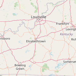
Geographic Location and Regional Setting of Mammoth Cave National Park
Mammoth Cave National Park lies within the United States, spanning Edmonson, Hart, and Barren counties in Kentucky. Regional database records confirm a fully inland status with no coastal or marine boundaries.
- Countries
- United States of America
- Regions
- Barren County, Edmonson County, Hart County, Kentucky
- Primary location
- Kentucky
- Geographic setting
- Inland
Boundary and coordinates
Interactive protected-area geometry and calculated spatial measurements
Mammoth Cave National Park Boundary Map and Spatial Extent
Mapped park boundaries provide precise spatial context for the surrounding protected terrain. Accompanying boundary facts detail total surface area, coordinate limits, and regional geographic spans.
- Boundary area
- 209.1 km²
- Boundary perimeter
- 116.8 km
- Northernmost point
- 37.2705° N
- Southernmost point
- 37.0977° N
- Easternmost point
- 86.0238° W
- Westernmost point
- 86.2677° W
- Geographic centre
- 37.1976° N, 86.1309° W
- North–south span
- 19.2 km
- East–west span
- 21.7 km
Terrain and natural features
Upland terrain classifications and mapped natural features within boundaries
Mammoth Cave National Park Terrain and Recorded Natural Features
Upland terrain classifications define the regional landscape while recorded sinkholes, caves, and streams sit within boundaries. Linked feature cards supply names, types, measurements, and spatial relationships.
Selected named natural features
Cave entrances
New Discovery Entrance
Streams
Houchin Hollow
Peaks
Goblin Knob
224 m
Cave entrances
Cathedral Domes
Rivers
Dry Prong Buffalo Creek
Environmental setting
Subtropical upland relief, extensive forest cover, and karst cave networks
Mammoth Cave National Park Environmental Settings and Landscape Classifications
Recorded landscape features, habitat types, and climate classifications provide structured interpretive categories for the physical setting. Associated data links these recorded attributes to related protected area classifications across the atlas.
- Relief
- Upland
- Climate
- Subtropical
- Water
- Major water bodies
- Forest cover
- Mostly forested
Landscape features
Cave · Karst · Rivers · Forest · Hills · Valleys · Waterfalls
Habitat types
Temperate broadleaf forest · Riverine habitat · Karst habitat
Park atlas
Trace regional park geography and compare diverse protected landscapes surrounding the Mammoth Cave area.
Explore Nearby National Parks and Protected Areas Around Mammoth Cave National Park
Explore beyond Mammoth Cave National Park by browsing other national parks and protected areas within its regional geography, encompassing diverse karst landscapes and vital forest ecosystems. Compare regional park geography and trace the broader patterns of protected lands, offering essential context for understanding conservation across the American South.
Protected landscapeIndiana
75 km away#1 closest
North

Hoosier National Forest: Geographic Overview of Indiana Protected Wilderness and Woodlands
Mapping the karst terrain and forest corridors of southern Indiana.
Hoosier National Forest defines the landscape of southern Indiana with its rolling unglaciated hills and ridge systems. Discover the mapped geography of this protected area, including its rare prairie-like barrens, sandstone cliff formations, and the designated Charles C. Deam Wilderness. This overview focuses on the spatial extent and diverse topographic features that distinguish this forest from the surrounding Midwest plains.
- Area
- 826.78 km²
- Established
- 1961
- Relief
- Upland
- Climate
- Temperate

Protected landscapeUnited States of America
158 km away#2 closest
West
Land Between the Lakes National Recreation Area: Mapped Geography and Protected Landscapes
An inland peninsula preserved between two major river reservoirs.
Land Between the Lakes National Recreation Area occupies a distinct narrow land bridge between Kentucky Lake and Lake Barkley. This protected landscape contains a dense mix of forested ridges, stream valleys, and managed wildlife prairies. The area is integral to the lower Ohio River Valley geography, showcasing the results of long-term watershed management and large-scale ecological restoration within the United States.
- Area
- 693.1 km²
- Established
- 1963
- Visitors
- 2M annual
- Relief
- Lowland

Protected landscapeIllinois
164 km away#3 closest
West
Shawnee National Forest: Exploring the Protected Landscapes of the Illinois Shawnee Hills
Mapped sandstone formations and glacial terrain in southern Illinois
Spanning nearly 289,000 hectares, Shawnee National Forest is the largest body of public land in Illinois. The area is defined by its dramatic sandstone bluffs, deep canyons, and seven designated wilderness areas that provide a rare rugged topography within the American Midwest. Explore the complex geography of this forest, from its glacial-sculpted river watersheds to its diverse hardwood habitats and historic reforestation sites.
- Area
- 2,017.83 km²
- Established
- 1933
- Relief
- Upland
- Climate
- Temperate

Wildlife reserveIllinois
191 km away#4 closest
West
Garden of the Gods Wilderness: A Protected Sandstone Plateau in Southern Illinois
Explore geologic boundaries, sandstone hoodoos, and forested wilderness terrain
Garden of the Gods Wilderness represents a critical protected area within the Shawnee National Forest, notable for its unglaciated sandstone geography. This 3,318-acre wilderness offers an intimate view of ancient carboniferous rock formations, including prominent hoodoos and clifftop overlooks that provide expansive sightlines across the southern Illinois landscape.
- Area
- 13.43 km²
- Established
- 1990
- Relief
- Upland
- Climate
- Temperate
Wildlife reserveIllinois
200 km away#5 closest
West
Lusk Creek Wilderness: An Atlas of Protected Sandstone Canyons and Forests in Southern Illinois
Mapping rugged wilderness terrain and forest ecological recovery.
Lusk Creek Wilderness serves as a key protected landscape in southern Illinois, featuring extensive sandstone canyon systems and dense hardwood woodland. This area offers a unique look at the geological and forested character of the Shawnee region, documented through its boundaries, elevation changes, and natural landmarks. Use this geographic entry to examine the rugged, roadless character of the state largest wilderness designation and its place within the wider regional drainage system.
- Area
- 25.47 km²
- Established
- 1990
- IUCN
- Ib
- Relief
- Upland
Wildlife reserveTennessee
245 km away#6 closest
Southeast
Gee Creek Wilderness: Geographic Atlas of an Appalachian Forested Wildlife Reserve
Protected mountain terrain in the Tennessee foothills
Gee Creek Wilderness is a federally protected area in southeastern Tennessee characterized by its small, roadless footprint and rich Appalachian forest composition. The reserve showcases the dramatic intersection of forested ridgelines and stream-carved valleys, providing a concentrated look at the ecological character of the Cherokee National Forest's lower Appalachian zone.
- Area
- 10.09 km²
- Established
- 1975
- IUCN
- Ib
- Relief
- Upland
National parkTennessee
249 km away#7 closest
Southeast
Great Smoky Mountains National Park: Exploring Its Protected Landscape and Regional Geography
Tennessee's premier national park, mapped for landscape discovery.
Delve into the protected area identity of Great Smoky Mountains National Park, a significant natural landmark within Tennessee. This page provides detailed context on its mountainous terrain, mapped ecological zones, and its foundational role in the broader geography of eastern North America. Understanding the park's specific protected landscape features and its geographic setting is essential for appreciating its unique conservation value.
- Area
- 2,114.15 km²
- Established
- 1934
- IUCN
- II
- Visitors
- 12.2M annual
Wildlife reserveNorth Carolina
258 km away#8 closest
Southeast
Joyce Kilmer-Slickrock Wilderness: Mapped Topography and Protected Forest Boundaries
Old-growth Appalachian wilderness in North Carolina
Analyze the dramatic valley-and-ridge geography of the Joyce Kilmer-Slickrock Wilderness. This protected area, encompassing the rare Joyce Kilmer Memorial Forest, serves as a vital reference for eastern forest conservation, featuring ancient hardwood groves and sweeping mountain vistas across the Unicoi range.
- Area
- 70 km²
- Established
- 1975
- IUCN
- Ib
- Relief
- Mountain
MoriAtlas Explorer
Continue Your Geographic Discovery of Mammoth Cave National Park's Protected Landscape
Delve further into the structured geographic data and mapped landscape context of Mammoth Cave National Park. Understanding its protected boundaries and regional setting provides essential insights for anyone interested in the atlas of US national parks and conservation areas. Explore the factual framework that defines this significant protected landscape for a richer appreciation of its natural geography.
Browse next
Global natural geography
Explore related park routes
Explore MoriAtlas Global ParksBrowse All MoriAtlas ParksGlobal Park Map DiscoveryMoriAtlas: Browse All CountriesBrowse All MoriAtlas ContinentsNational Park Environment AtlasGrand Canyon National Park AtlasYellowstone National Park AtlasYosemite National Park Atlas and GeographySerengeti National Park AtlasGalápagos National Park Protected LandscapeBanff National Park Geography and AtlasKruger National Park Atlas EntryUluṟu-Kata Tjuṯa National Park AtlasExplore Uluru-Kata Tjuta National Park GeographyPlitvice Lakes National Park AtlasFiordland National Park Protected LandscapeGreat Smoky Mountains National Park AtlasAfghanistan National Parks and Protected AreasAlbania National Parks and Protected AreasAlgeria National Parks and Protected AreasAmerican Samoa National Parks and Protected AreasAndorra National Parks and Protected AreasAngola National Parks and Protected AreasAntarctica National Parks and Protected AreasAntigua and Barbuda Park List