
Why Mamungari Conservation Park stands out
Mamungari is best known for its sheer scale, its role as a UNESCO Biosphere Reserve within Australia's arid interior, and its rare joint management arrangement with Aboriginal traditional owners. The park is associated with two of Australia's most iconic desert regions, the Great Victoria Desert and the Nullarbor Plain, and includes features such as the Serpentine Lakes, a culturally and ecologically important chain of salt lakes in the desert landscape. Its legacy also includes a remarkable political and cultural moment: the 2004 return of more than 21,000 square kilometres of land to the Maralinga Tjarutja and Pila Nguru people, which transformed how Mamungari is governed and recognised.
Mamungari Conservation Park history and protected-area timeline
Mamungari Conservation Park was proclaimed in 1970 as a national park under South Australia's National Parks Act 1966, with the original purpose of conserving the environments of the Great Victoria Desert and safeguarding its wilderness values. At the time of proclamation, the park was not given a formal name. Under the National Parks and Wildlife Act 1972, the area became known as the Unnamed Conservation Park, a designation it carried for decades while continuing to function as a formal state protected area.
The park's international significance was recognised early. In 1977, it was designated as a UNESCO Biosphere Reserve under the name Unnamed Biosphere Reserve, becoming one of fourteen such reserves in Australia. Its listing on the now-defunct Register of the National Estate in 1980 added another layer of heritage recognition. For many years, the park's identifying anonymity stood in contrast to its conservation importance.
The political and cultural history of Mamungari took a major turn in 2004. Following special legislation, South Australian Premier Mike Rann handed back title to approximately 21,000 square kilometres of land to the Maralinga Tjarutja and Pila Nguru people, including the conservation park and the Serpentine Lakes area. This fulfilled a pledge made by Rann as Aboriginal Affairs Minister in 1991 to Maralinga leader Archie Barton, and marked the largest return of land under native title in South Australia since Premier John Bannon's handover of the Maralinga lands in 1984.
In recognition of this new custodial arrangement and the renewed cultural significance of the area, the park was officially renamed Mamungari Conservation Park on 30 November 2006, replacing the long-standing Unnamed designation and affirming the identity of the place today.
Mamungari Conservation Park landscape and geographic character
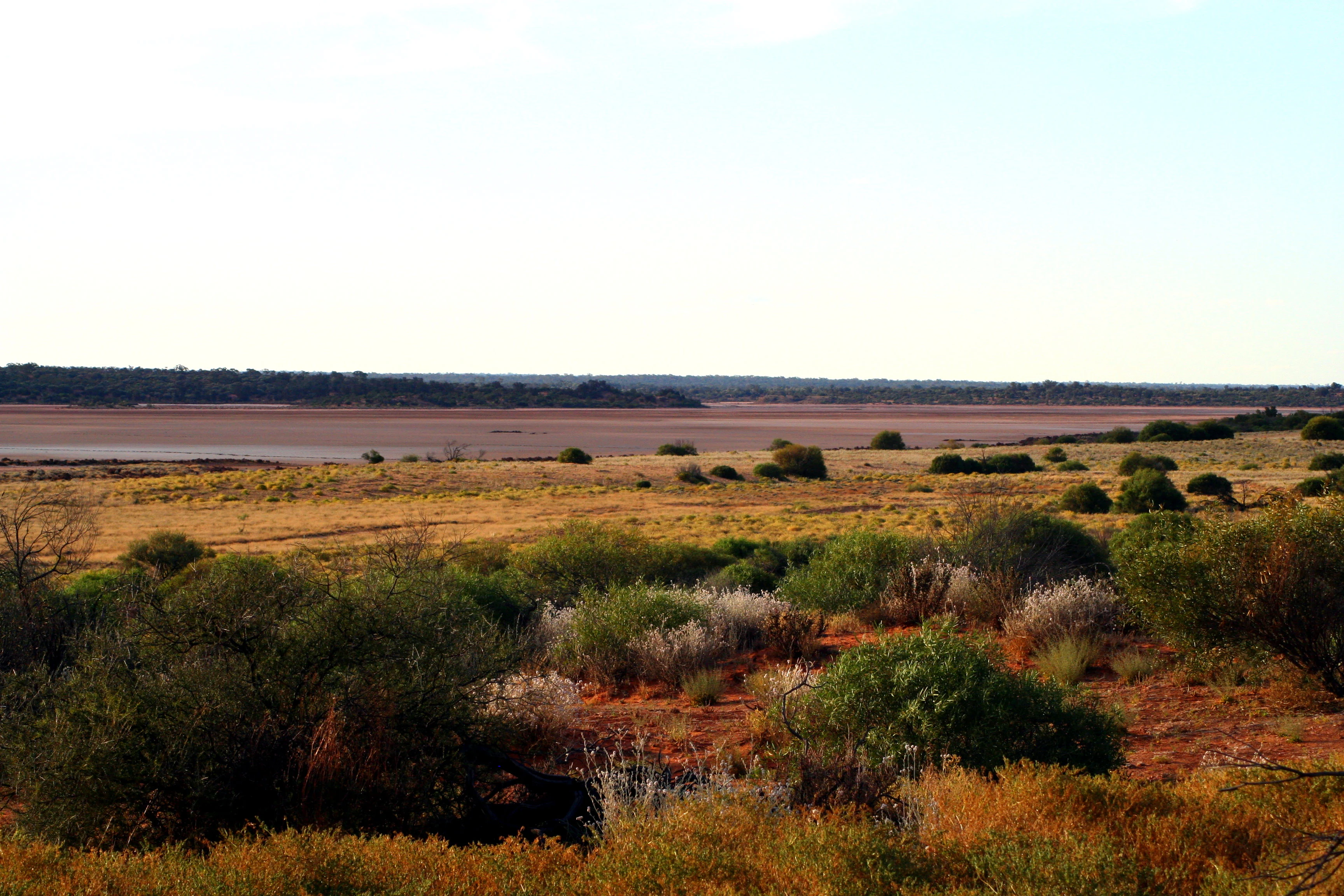
The landscape of Mamungari Conservation Park is shaped by the deep, slow geology of Australia's arid interior. The park covers a vast tract of desert country where shifting sandplains give way to dune ridges, broad claypans, scattered rocky outcrops, and chains of salt lakes. Topography is generally subdued, but the sheer scale of the terrain produces an environment of striking visual openness, with horizons that stretch uninterrupted for vast distances.
In the southern sections, the park transitions into the northern fringe of the Nullarbor Plain, where flat limestone country contrasts with the more undulating desert terrain of the Great Victoria Desert to the north. Between these two major landscapes lies a transitional zone of mixed sand and stone, typical of the southern Australian arid zone.
The Serpentine Lakes are the most widely recognised landform within the park. These chains of salt lakes, located along the southern portion of the conservation park, have long held importance as a landmark for travellers crossing the desert, including those on the Anne Beadell Highway. The lakes, now dry for much of the time, still define the surrounding landscape with their pale salt margins and the subtle vegetation patterns that follow them across the desert floor.
Mamungari Conservation Park ecosystems, habitats, and plant life
Mamungari sits within the Australian arid biome, where ecosystems are defined by heat, drought, and the rhythms of highly variable rainfall. The park's habitats include open desert sandplains, dune fields strewn with spinifex and low shrubs, patches of arid woodland, and open chenopod shrublands that thrive in the heavier soils of claypans and drainage lines. The variable terrain produces a mosaic of plant communities, each adapted to different soil types and moisture regimes.
Vegetation cover is typically sparse but resilient. Hardy species dominate, including mulga and other acacias, saltbush, bluebush, and a range of small desert shrubs and grasses. Around the salt lakes and drainage corridors, plant life becomes slightly more concentrated, creating narrow but ecologically important vegetated zones that support both terrestrial wildlife and transient bird species.
As an IUCN Category Ia strict nature reserve, the conservation park is managed with the primary goal of preserving ecological processes and wilderness character with minimal intervention. This high level of protection recognises the ecological significance of an arid environment that remains largely unmodified and that sustains biological communities adapted to one of Australia's harshest climates.
Mamungari Conservation Park wildlife and species highlights
Wildlife in Mamungari Conservation Park is shaped by the demands of desert survival, with species ranging widely across the landscape in search of food, water, and shelter. The park supports typical arid-zone fauna, including kangaroos and other macropods that move across the open sandplains and dune country. Reptiles are especially prominent, given the warm climate and abundance of shaded refuge sites among rocks, fallen timber, and desert shrubs. Lizards and snakes are integral parts of the desert food web.
Bird life varies with conditions across the year. The park supports a range of arid-adapted bird species that move through the landscape in response to rainfall and seasonal change. Around the Serpentine Lakes and other temporary water features, birds concentrate during and after rain events, offering some of the park's most visible displays of life in the desert.
The conservation value of Mamungari lies significantly in the ability of its wildlife populations to function within a largely intact and unmodified habitat. With minimal infrastructure and strict protective status, the park offers a rare example of an Australian desert ecosystem whose ecological relationships have not been substantially disrupted by human development, allowing predator and prey dynamics, dispersal patterns, and seasonal movements to operate as they have for thousands of years.
Mamungari Conservation Park conservation status and protection priorities
Mamungari Conservation Park holds a particularly high place within Australia's conservation framework. Its designation as an IUCN Category Ia strict nature reserve places it among the most strictly protected categories of land on the continent, set aside primarily for the preservation of ecosystems and wilderness values rather than for public recreation. This level of protection reflects both the ecological fragility of the arid zone and the importance of maintaining large, intact landscapes where ecological processes can continue with minimal interference.
The park's status as a UNESCO Biosphere Reserve since 1977 underscores its global significance. Biosphere Reserves are recognised for their importance to biodiversity conservation and for their role in supporting sustainable relationships between people and the environment. Mamungari's inclusion reflects the international value of its desert ecosystems and the cultural traditions that continue to shape how the land is cared for.
Beyond formal designations, the conservation significance of Mamungari is reinforced by its joint management arrangement. The partnership between the Department for Environment and Water and the Maralinga Tjarutja and Pila Nguru traditional owners recognises that ecological protection in this landscape is inseparable from the cultural responsibilities of its Aboriginal custodians. The 2004 land return embedded Aboriginal governance directly into the park's conservation framework, creating a model in which ecological and cultural continuity reinforce one another. This combination of strict legal protection, international recognition, and Indigenous-led stewardship gives Mamungari a distinctive and enduring conservation profile.
Mamungari Conservation Park cultural meaning and human context
Mamungari Conservation Park lies within the traditional country of the Maralinga Tjarutja and Pila Nguru people, Aboriginal groups with longstanding connections to the southern Great Victoria Desert and the northern Nullarbor Plain. The desert landscape, including features such as the Serpentine Lakes, has long held cultural significance, and Aboriginal knowledge of the region's water sources, seasonal patterns, and resources continues to shape how the land is understood and cared for.
The 2004 handback of more than 21,000 square kilometres to the Maralinga Tjarutja and Pila Nguru people was a defining cultural moment for the area, restoring formal recognition of Aboriginal ownership over land that had been progressively alienated through earlier policies, including the history of nuclear testing in the broader Maralinga region. Today, Mamungari is governed through a model in which Aboriginal people hold title and act as co-managers alongside state authorities.
The renaming of the park in 2006, moving from the long-used Unnamed designation to Mamungari, itself reflects a process of cultural re-identification. The name change, combined with joint management, has helped anchor the park's contemporary identity in the cultural and linguistic heritage of the region rather than in its former anonymous administrative status.
Best time to visit Mamungari Conservation Park
Mamungari Conservation Park is a remote and strictly protected area, and visiting it is only possible by permit and with demonstrated experience in low-impact desert travel. Because of these access constraints, the most relevant seasonal considerations relate to the conditions of the desert itself rather than typical tourism patterns.
The cooler months between late autumn and early spring offer the most comfortable conditions for desert travel, with lower daytime temperatures and safer conditions for traversing the open landscapes of the Great Victoria Desert and the northern Nullarbor Plain. Rainfall in the region is infrequent and unpredictable, but when it does arrive it can transform the park temporarily, encouraging wildflowers, fresh vegetation growth, and animal activity around the salt lakes and drainage lines.
Summer in this part of South Australia brings extreme heat, making travel both more dangerous and less comfortable. Those considering an extended visit should also recognise that the park's cultural and ecological sensitivities require careful planning, respect for traditional owners, and an emphasis on minimal impact on both the environment and the communities connected to it.