

Mori Atlas logo
Nature reserveMandena Conservation Zone

Examining the ecological boundaries and terrain of a critical coastal conservation landscape

Mandena Conservation Zone: A Rare Protected Littoral Forest and Coastal Wetland in Madagascar

Mandena Conservation Zone preserves a vanishing fragment of Madagascar's coastal geography, where dense littoral forest and freshwater swamps converge near the southeastern shoreline. This nature reserve serves as an essential biodiversity refuge, protecting endemic lemur species within one of the island's most threatened ecosystems. The landscape offers a window into the natural history of the Tolagnaro region, characterized by humid tropical conditions and a unique transition between waterlogged terrain and sandy-soil woodland.

littoral forestcoastal swampendemic lemursMadagascarprotected areahumid tropical climate

Mandena Conservation Zone

Nature reserve

Park overview

Structured park overview, official facts, and landscape profile for Mandena Conservation Zone

Mandena Conservation Zone park facts, protected area profile, and essential visitor context

Review the core facts for Mandena Conservation Zone, including designation, size, terrain, visitor scale, habitats, and operating context in one park-focused overview.

About Mandena Conservation Zone

Mandena Conservation Zone is a compact protected area in the far southeast of Madagascar, near the country's southernmost major coastal town of Fort Dauphin. Its location, just a few kilometers from the Indian Ocean coast, places it firmly within the narrow belt of humid coastal habitat that historically lined this stretch of the island. The zone is small in scale but ecologically concentrated, combining freshwater swamp with a remnant of littoral forest in close proximity.

The landscape of Mandena reflects the transitional geography of southeast Madagascar, where coastal plains, wetlands, and forest patches meet in a humid tropical setting. Annual rainfall is very high, with most precipitation arriving during the long rainy season that stretches from November through April. The climate supports dense vegetation, but also places the reserve within a fragile ecological zone shaped by seasonal flooding, salt influence, and long-term human pressure on the surrounding land.

Madagascar's littoral forest is one of the rarest forest formations on the island, having been reduced to a small fraction of its original extent due to clearance for agriculture, charcoal production, and coastal development. Reserves like Mandena therefore hold disproportionate importance for biodiversity, despite their modest size. The zone's combination of forest and swamp creates a varied microhabitat structure that supports a wide range of species within a very limited area.

For visitors, researchers, and conservation planners, Mandena represents a textbook example of a small but high-value protected site: geographically constrained, climatically rich, and biologically distinctive. Its proximity to Fort Dauphin also makes it a key piece of the regional conservation landscape in the Tolagnaro area, where multiple reserves together attempt to maintain ecological connectivity in a heavily modified coastal region.

Quick facts and research context for Mandena Conservation Zone

Mandena Conservation Zone is a protected coastal reserve covering roughly 230 hectares in southeastern Madagascar, of which 82 hectares are swamp and 148 hectares are littoral forest.

It lies about ten kilometers north of Fort Dauphin and approximately three kilometers from the southeast coast, on a humid stretch of the island that receives close to 2,800 millimeters of rainfall annually. The reserve is known especially for its populations of endemic lemurs and its role in safeguarding one of Madagascar's most reduced forest habitats.

Protection and recognition

Documented protection scope and conservation status records

Mandena Conservation Zone Protection Status and International Recognition

Mandena Conservation Zone holds a mixed protection scope outlining documented management parameters and conservation boundaries. Official records organize international recognition frameworks alongside administrative status for this protected landscape.

Protection details

Protection scope
Mixed
Transboundary protection
No
Park context

Deeper park guide and search-rich context for Mandena Conservation Zone

Mandena Conservation Zone history, landscape, wildlife, and travel context

Explore Mandena Conservation Zone through its history, landscape character, ecosystems, wildlife, conservation priorities, cultural context, and seasonal travel timing in a structured park guide built for atlas discovery and search intent.

Why Mandena Conservation Zone stands out

Mandena is best known for protecting one of the last remaining stands of Madagascar's littoral forest, a coastal forest type that has been extensively cleared across the island. Within this small reserve, multiple endemic lemur species share habitat with swamp and transitional coastal vegetation, making the zone a notable refuge for wildlife adapted to the narrow ecological corridor between sea and forest. The reserve is also recognized for its importance in regional conservation, sitting near Fort Dauphin and forming part of a fragmented but ecologically critical network of protected sites in southeastern Madagascar.

Mandena Conservation Zone landscape and geographic character

The landscape of Mandena Conservation Zone is shaped by its position close to the southeast coast of Madagascar, where the terrain transitions from coastal lowlands into a strip of forest and wetland. The reserve's two principal habitats are littoral forest, a low, dense coastal forest type adapted to sandy soils and salt-influenced air, and freshwater swamp, which occupies the lower-lying ground.

The climate supports this landscape strongly, with annual rainfall approaching 2,800 millimeters and a temperature range that stays warm throughout the year. During the rainy season, swamps expand and forest undergrowth thickens, while the drier months bring shorter vegetation and easier visibility through the woodland. The topography is generally flat to gently undulating, typical of the southeastern coastal belt, but the ecological contrast between waterlogged swamp and dry-ground forest gives the zone a varied internal character despite its small size.

Because the surrounding region has seen extensive forest clearance, the patches of littoral forest within Mandena stand out as increasingly rare remnants of a once more widespread coastal ecosystem.

Mandena Conservation Zone ecosystems, habitats, and plant life

Ecologically, Mandena Conservation Zone straddles the boundary between two closely interrelated habitats: littoral forest and coastal swamp. Littoral forest is one of the most threatened forest formations in Madagascar, surviving today only in small fragments along the coast due to centuries of clearance for timber, charcoal, and slash-and-burn agriculture. The swamp component adds a wetland dimension that is uncommon in the otherwise dry coastal belt to the south.

The combination supports a rich vertical and horizontal habitat structure in a very small area. Forest canopy, understory, swamp margins, and open wet zones each host different plant and animal communities, allowing the reserve to sustain surprising biodiversity despite its modest footprint. The climate, with heavy seasonal rain and consistently warm temperatures, fuels dense plant growth and a year-round supply of food resources for fruit-eating, insect-eating, and nectar-feeding species.

For the broader Tolagnaro region, Mandena also functions as an ecological node within a fragmented network of forest patches and wetlands, contributing to the survival of species that depend on the southeast's narrow coastal habitat corridor.

Mandena Conservation Zone wildlife and species highlights

Mandena is particularly notable for its lemur populations, which include several endemic species of high conservation interest. Among the primates recorded in the zone are Ganzhorn's mouse lemur, the eastern form of the fat-tailed dwarf lemur, the greater dwarf lemur, the southern woolly lemur, the southern lesser bamboo lemur, and collared brown lemurs. Each occupies a slightly different ecological niche within the forest and swamp habitats.

Beyond lemurs, the reserve supports the Madagascan flying fox, a large fruit bat that plays an important ecological role as a pollinator and seed disperser across Madagascar's humid forests. The presence of this species within the zone reflects the broader health and seasonal productivity of the local vegetation, particularly the fruit-bearing trees of the littoral forest.

The swamp and forest combination also provides habitat for reptiles, amphibians, and a wide range of invertebrates, while the seasonal abundance of insects supports insectivorous lemurs and bats alike. The small size of the reserve makes every fragment of habitat valuable, and the diversity recorded suggests that Mandena retains a functional, if compressed, version of the region's native wildlife community.

Mandena Conservation Zone conservation status and protection priorities

Mandena Conservation Zone is significant from a conservation perspective primarily because it safeguards a portion of Madagascar's littoral forest, a formation that has been reduced to less than a tenth of its original extent and is considered one of the most threatened forest types on the island. By protecting both forest and adjacent swamp, the reserve maintains habitats that are otherwise almost entirely lost in the surrounding region near Fort Dauphin.

Its small area belies its biodiversity value. The zone supports multiple lemur species, many of which are endemic to Madagascar and several of which have restricted ranges. This makes the reserve a high-priority site for maintaining population viability, particularly when considered alongside other protected areas in the southeast.

As part of a broader regional conservation effort in the Tolagnaro area, Mandena also contributes to goals related to habitat connectivity, species monitoring, and environmental education. Its continued protection is tied to broader efforts to slow deforestation and habitat fragmentation along Madagascar's southeastern coast.

Mandena Conservation Zone cultural meaning and human context

Mandena sits within the Anosy region of southeastern Madagascar, an area with a long history of human settlement along the coast near Fort Dauphin. The surrounding landscape reflects long-standing patterns of agriculture, fishing, and resource use that have shaped coastal Madagascar for centuries.

Because the littoral forest has historically been reduced by human activity, including clearance for subsistence farming and charcoal, the reserve's protected status represents both a conservation intervention and an acknowledgment of the cultural and economic pressures on local land. Communities in the Tolagnaro region continue to interact closely with natural resources, and small reserves like Mandena often sit within a broader cultural landscape where traditional use, modern livelihoods, and conservation priorities intersect. However, the source material does not provide rich detail on specific local cultural traditions tied to the reserve itself, so deeper cultural framing remains limited.

Top sights and standout views in Mandena Conservation Zone

Mandena Conservation Zone stands out for combining two of Madagascar's most fragile habitats: littoral forest and coastal swamp, within a remarkably compact area of about 230 hectares.

Its lemur diversity is unusually high for such a small reserve, supporting several endemic species alongside the Madagascan flying fox. The zone also plays an important regional role in protecting southeast Madagascar's coastal ecosystems, where similar habitat has been almost entirely lost elsewhere along the shore near Fort Dauphin.

Best time to visit Mandena Conservation Zone

The character of Mandena shifts noticeably with the seasons. The long rainy season, from November through April, fills the swamps, intensifies forest growth, and brings out the full vibrancy of the littoral forest, but also makes access more challenging due to wet conditions and higher humidity.

The drier months, roughly May through October, offer cooler temperatures, lower rainfall, and easier movement through the forest and swamp margins, while still supporting active wildlife, including lemurs that remain present year-round. For visitors interested in both landscape and wildlife viewing, the dry season typically provides a more comfortable experience, while the wet season showcases the zone at its most lush and ecologically active.
Monthly climate preview

Long term representative measurements tracking monthly temperature and precipitation patterns

Mandena Conservation Zone Climate Normals and Annual Temperature Rhythm

Representative coordinate records show measured monthly temperature and precipitation variations across the conservation zone from 1991 to 2020. Examining the complete twelve month profile provides detailed climatological data for comparative geographical analysis.
Annual mean23 °C
19 °C25 °C
Jan25°
Feb25°
Mar25°
Apr23°
May21°
Jun20°
Jul19°
Aug20°
Sep21°
Oct23°
Nov24°
Dec25°
Warmest month
January

25.3 °C

Coolest month
July

19.2 °C

Wettest month
February

7 mm/day

Driest month
September

1.4 mm/day

Park location guide

Geography guide, regional context, and park location map for Mandena Conservation Zone

Mandena Conservation Zone park geography, regions, and map view in Madagascar

Understand where Mandena Conservation Zone sits in Madagascar through a broader geographic reading of the surrounding landscape, nearby location context, and its mapped position within the national park landscape.

How Mandena Conservation Zone fits into Madagascar

Madagascar is an island nation in the Indian Ocean, positioned off the southeastern coast of Africa. As the world's fourth-largest island and second-largest island country, it stands out for its exceptional biodiversity, over 90% of its wildlife is endemic, making it one of 17 megadiverse countries. The population is approximately 32 million, with Antananarivo as both the capital and largest city.

Wider geography shaping Mandena Conservation Zone in Madagascar

Madagascar lies in the Indian Ocean off the southeastern coast of Africa, separated from the mainland by the Mozambique Channel. The island is situated approximately 400 km from the African continent. As the world's fourth-largest island, it also includes numerous smaller peripheral islands.

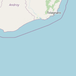
Map view of Mandena Conservation Zone

Use this park location map to pinpoint Mandena Conservation Zone in Madagascar, understand its exact geographic position, and read its mapped placement within the surrounding landscape more clearly.

Pigeon | © OpenStreetMap contributors
Park atlas

Compare regional biodiversity refuges and coastal forest habitats across southeastern Madagascar

Explore Parks Near Mandena Conservation Zone and Surrounding Protected Areas

Continue geographic discovery by comparing Mandena Conservation Zone with other protected areas located throughout the surrounding southeastern coastal region. This comparative view reveals how fragmented wetland reserves and rare littoral forests connect across the wider regional landscape.
Nature reserveMadagascar
About 24 km away#1 closest

Northeast

Sainte Luce Reserve: Mapping Madagascar's Coastal Rainforest and Nature Reserve Boundaries

Coastal littoral forest, rare ebony enclaves, and mangrove ecosystems.

Located on the southeastern coast of Madagascar, Sainte Luce Reserve represents an intensive conservation area for littoral forest ecosystems. The reserve protects a unique linear landscape of Pandanus rainforests, white-sand ebony stands, and riverine mangroves, serving as a sanctuary for endangered palms and various endemic lemur species within its concentrated geographic footprint.

Area
0.4 km²
Established
2009
Visitors
50 annual
Relief
Lowland
Nature reserveAnosy
About 28 km away#2 closest

North

Tsitongambarika Nature Reserve: Geographic Profile and Protected Forest Landscape

Lowland humid evergreen forest in the Anosy region

Tsitongambarika represents one of the final remaining lowland humid evergreen forest tracts in southern Madagascar. The reserve encompasses an extensive massif of ridges and the isolated Mount Ivohibe, supporting complex drainage networks that sustain the coastal water supply of the Anosy region. This protected landscape is fundamental for preserving regional biodiversity, including endemic lemurs, palm species, and specialized forest bird habitats across the southeastern Madagascar terrain.

Area
585.97 km²
Established
2015
IUCN
VI
Relief
Mountain
National parkMadagascar
About 49 km away#3 closest

Northwest

Andohahela National Park: Protected Landscape and Geographic Atlas Context in Madagascar

Explore the mapped terrain and regional park geography.

Understand Andohahela National Park as a distinct national park entity, focusing on its geographic setting and protected landscape characteristics within Madagascar. This detail page provides structured data on the park's mapped boundaries and its regional importance, offering insights for anyone exploring protected areas and natural terrain through a geographic lens. It is an essential resource for understanding the park's specific context in the broader atlas.

Area
760 km²
Established
1998
IUCN
II
Visitors
1.3K annual
Wildlife reserveAnosy
About 70 km away#4 closest

West

Berenty Reserve Wildlife Reserve in the Anosy Region of Southern Madagascar

Spiny forest ecology and riverine landscape mapping

Berenty Reserve offers a concentrated look at the semi-arid spiny forests of southern Madagascar. This wildlife reserve, located along the Mandrare River in the Anosy region, serves as a vital protected area for observing endemic species within a striking terrain of cactus-like plants, baobabs, and thorny thickets.

Relief
Lowland
Climate
Arid
Access
Moderate access
Scope
Terrestrial
National parkAtsimo-Atsinanana
About 161 km away#5 closest

North

Midongy du sud National Park: National Park in Atsimo-Atsinanana, Madagascar

Explore its protected landscape and mapped geography.

Midongy du sud National Park is a significant protected area located in the Atsimo-Atsinanana region of Madagascar. This entry provides detailed geographic context, focusing on the park's mapped boundaries and its identity as a national park. It supports atlas-based discovery by offering insights into the park's specific landscape and its regional setting within southeastern Madagascar, serving as a factual resource for understanding its protected status.

Area
1,922 km²
Established
1997
IUCN
II
Relief
Mountain
Wildlife reserveMadagascar
About 172 km away#6 closest

North

Kalambatritra Special Reserve: Exploring the Geography of Southern Madagascar Protected Lands

Mapping a unique humid highland forest refuge

The Kalambatritra Special Reserve comprises a significant forested block in southern Madagascar, defined by ridges and valleys that maintain a humid microclimate. This protected area serves as a critical habitat for endemic wildlife, bridging the gap between eastern forest ecosystems and the drier terrain of the southern plateau, providing an essential study in island geography and conservation.

Area
282.55 km²
Established
1959
IUCN
IV
Scope
Terrestrial
Wildlife reserveAndroy
About 196 km away#7 closest

West

Réserve spéciale du Cap Sainte-Marie: Wildlife Reserve and Protected Coastal Landscape in Androy

An essential arid-zone habitat at the southernmost edge of Madagascar

Réserve spéciale du Cap Sainte-Marie protects a fragile ecosystem of spiny thicket and coastal terrain. As a focal point for tortoise conservation in the Androy region, this reserve offers a window into the specialized reptile habitats and harsh environmental conditions that define the southern extremity of the Madagascar landscape.

Area
17.5 km²
Established
1962
IUCN
IV
Scope
Terrestrial
Marine protected areaAtsimo-Andrefana
About 216 km away#8 closest

West

Nosy Ve-Androka National Park Marine Protected Area: Geographic and Atlas Discovery

Understand its marine landscape and regional geographic context.

Delve into Nosy Ve-Androka National Park, a critical marine protected area located in Madagascar's Atsimo-Andrefana region. This park offers a focused look at protected marine geography, allowing for detailed atlas exploration of its mapped boundaries and its role within the surrounding natural landscapes. Understand the specific geographic identity and conservation significance of this vital protected area through structured data.

Area
914.45 km²
Climate
Tropical
Access
Moderate access
Water
Water-dominated

Common questions about visiting, size, designation, and location context for Mandena Conservation Zone

Mandena Conservation Zone FAQs for park facts, access, geography, and protected area context

Find quick answers about Mandena Conservation Zone, including protected-area facts, park geography, trail and visitor context, and how the park fits into its surrounding country and regional landscape.
MoriAtlas Explorer

Continue Your Protected Areas Search Across the Global Atlas

Deepen your exploration by continuing the structured search for national parks and protected areas worldwide. Utilize the comprehensive filtering capabilities to compare different conservation landscapes and refine your understanding of global park geography. Discover more about the distribution and characteristics of protected natural areas.

Global natural geography