

Mori Atlas logo
Wildlife reserveManombo Special Reserve

Tracing the protected boundaries and coastal terrain of a critical southeastern Madagascar wildlife reserve.

Manombo Special Reserve: Mapping the Humid Lowland Rainforests of Atsimo-Atsinanana

(Réserve spéciale de Manombo)

Manombo Special Reserve preserves 5,320 hectares of rare humid lowland forest within the Atsimo-Atsinanana region of southeastern Madagascar. Located near the Indian Ocean, the reserve is defined by a fragmented landscape of rainforest, wetland corridors, and small alluvial valleys bisected by National Route 12. This protected area serves as an essential refuge for high concentrations of endemic plant and primate species, functioning as a critical site for studying the ecology of Madagascar's eastern coastal plain.

lowland rainforesthumid eastern forestendemic specieslemursamphibianswetland habitats

Manombo Special Reserve

Wildlife reserve

Park overview

Structured park overview, official facts, and landscape profile for Manombo Special Reserve

Manombo Special Reserve park facts, protected area profile, and essential visitor context

Review the core facts for Manombo Special Reserve, including designation, size, terrain, visitor scale, habitats, and operating context in one park-focused overview.

About Manombo Special Reserve

Manombo Special Reserve is one of Madagascar's older designated protected areas, established in 1956 to safeguard a representative stretch of the country's threatened humid eastern rainforest. The reserve lies in the Atsimo-Atsinanana region along the southeastern coast, close to the Indian Ocean and approximately 27 kilometers south of Farafangana. Its terrain reflects the characteristic eastern Malagasy lowland landscape: a mix of evergreen rainforest, swamp forest, marshy corridors, and transitional zones near the coast, all lying within a relatively narrow coastal-plain strip.

Administratively, Manombo is a special reserve under the management of Madagascar National Parks, classified at IUCN Category IV, which designates it primarily for the conservation of species and habitats through active management. The reserve's territory spans roughly 5,320 hectares, organized into two non-contiguous parcels divided by National Route 12, a road that runs along Madagascar's southeast coast and connects to the country's broader transport network.

Ecologically, Manombo stands out within Madagascar's protected-area system because of its exceptionally high proportion of endemic species, with around 90 percent of the species recorded in the reserve found nowhere else in the world. This endemism spans multiple groups, from trees and other plants to amphibians, reptiles, mammals, and invertebrates. The reserve is widely studied for its lemur populations, which include a remarkable number of threatened species, and for its contribution to understanding the unique evolutionary history of Madagascar's eastern rainforest biome.

Quick facts and research context for Manombo Special Reserve

Manombo Special Reserve is located in southeastern Madagascar in the Atsimo-Atsinanana region, close to the Indian Ocean coast and south of Farafangana. It was established in 1956 and is administered by Madagascar National Parks. The reserve covers approximately 5,320 hectares and is split into two parcels by National Route 12. It holds IUCN Category IV status and is part of Madagascar's network of protected areas focused on conserving humid lowland forest and associated biodiversity.

Protection and recognition

Documented conservation status, official boundaries, and global database records

Manombo Special Reserve Protection Status and International Recognition

Manombo Special Reserve holds structured protection records within the global protected area registry. Official database entries catalog management scope and formal designation criteria for conservation analysis.

Protection details

WDPA ID
5028
Park context

Deeper park guide and search-rich context for Manombo Special Reserve

Manombo Special Reserve history, landscape, wildlife, and travel context

Explore Manombo Special Reserve through its history, landscape character, ecosystems, wildlife, conservation priorities, cultural context, and seasonal travel timing in a structured park guide built for atlas discovery and search intent.

Why Manombo Special Reserve stands out

Manombo is known primarily for its humid lowland rainforest habitat and exceptionally high level of species endemism, with about 90 percent of recorded species being endemic to Madagascar. The reserve supports several threatened lemur species, including the critically endangered white-collared brown lemur (Eulemur cinereiceps), and an unusual concentration of narrow-range plants such as Humbertia madagascariensis. It also serves as an important site for studies of threatened amphibians, including Mantella bernhardi.
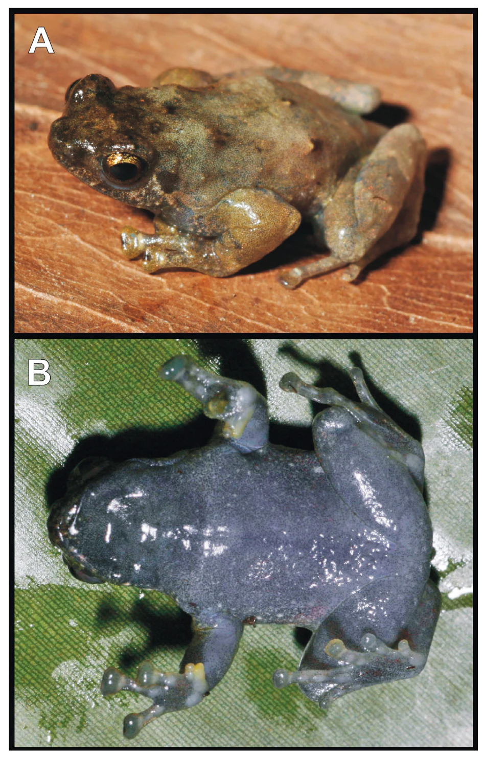
Anodonthyla theoi specimen
A living specimen of the frog species Anodonthyla theoi from Manombo Special Reserve shown in dorsolateral and ventral views.

Manombo Special Reserve history and protected-area timeline

The Manombo Special Reserve was created in 1956 as part of Madagascar's early efforts to formally protect representative samples of the country's natural ecosystems. Located along the southeastern coast in the Atsimo-Atsinanana region, the reserve was established to conserve a tract of humid lowland rainforest that was already under growing pressure from logging, agricultural expansion, and coastal development. Its division into two parcels reflects the historical route alignment of National Route 12 through the area.

Today the reserve is administered by Madagascar National Parks, the national agency responsible for managing Madagascar's network of protected areas. Over time, Manombo has become an important reference site for scientific research on eastern Malagasy rainforest ecosystems, particularly for studies of endemic lemurs, amphibians, and plants.

Manombo Special Reserve landscape and geographic character

Manombo lies within the narrow coastal plain of southeastern Madagascar, where humid eastern rainforest meets the Indian Ocean shoreline. The reserve's elevation is generally low, with terrain shaped by river systems, marshy corridors, and small alluvial valleys that drain eastward toward the sea. The forest cover is a mosaic of evergreen and semi-deciduous lowland rainforest, with swamp-forest patches and open marsh areas interspersed throughout.

Because National Route 12 runs through the landscape, the reserve is split into two main parcels on either side of the road. This fragmented configuration is an important feature of the site, as it has influenced both ecological patterns and conservation management in the area.

Manombo Special Reserve ecosystems, habitats, and plant life

The ecological character of Manombo is defined by its humid lowland forest habitats and the exceptionally high share of species that occur only in Madagascar. Roughly 90 percent of the species documented in the reserve are endemic to the island, giving the area a strong reputation among biologists for evolutionary and biogeographic study.

Habitat types include closed evergreen rainforest, canopy-dominated forest with emergent trees, and wetter swamp-forest communities associated with the reserve's many small watercourses. These habitats support a broad array of plant groups, including endemic trees such as Humbertia madagascariensis and members of the genus Allantospermum, which is represented in the reserve by one of only two known species worldwide. The reserve's botanical composition reflects the regional flora of southeastern Madagascar, with strong representation of humid-forest specialists.

Manombo Special Reserve wildlife and species highlights

Manombo is particularly important for primates, hosting several lemur species of high conservation concern. Among them are the woolly avahi (Avahi laniger), the aye-aye, the reddish mouse lemur (Microcebus rufus), the eastern lesser bamboo lemur or grey bamboo lemur (Hapalemur griseus), the white-collared brown lemur (Eulemur cinereiceps), and the white-and-black ruffed lemur (Varecia variegata). Eulemur cinereiceps is recognized as one of the 25 most threatened primate species in the world, making Manombo a key site for its survival.

The reserve also supports a diverse herpetofauna, with the threatened frog Mantella bernhardi among the notable amphibian inhabitants. Other iconic mammals present include the aquatic tenrec (Limnogale), the falanouc (Eupleres goudotii), the fossa (Cryptoprocta ferox), the ring-tailed mongoose (Galidia elegans), and endemic rodents such as Brachyuromys betsileonsis and Nesomys audeberti. Birdlife is also rich, with around 58 recorded bird species recorded in the reserve, and the invertebrate fauna includes around 52 species of snails, contributing to Manombo's profile as a biodiversity hotspot within Madagascar's eastern rainforest.

Manombo Special Reserve conservation status and protection priorities

Manombo Special Reserve plays a significant role in conserving Madagascar's eastern humid forest biodiversity, one of the most threatened ecosystems on the island. Its combination of lowland rainforest, swamp forest, and coastal transition habitats supports a high concentration of endemic and threatened species, including several lemurs listed among the rarest primates in the world. The reserve's IUCN Category IV designation reflects its focus on active habitat and species protection.

By protecting a substantial block of lowland forest south of Farafangana, Manombo contributes to maintaining ecological connectivity in the southeastern coastal region and provides an important long-term reference site for research on rainforest endemism, species recovery, and habitat management in Madagascar. Its inclusion in the Madagascar National Parks system gives it a recognized institutional framework for ongoing conservation effort.

Manombo Special Reserve cultural meaning and human context

Manombo is situated in a region of southeastern Madagascar with long-established rural communities whose livelihoods are traditionally tied to the surrounding forests, rivers, and coastal resources. While the reserve is primarily valued for its biodiversity and scientific importance, its presence in this landscape also reflects the broader relationship between local populations and the remaining eastern rainforest. The nearby town of Farafangana serves as the main regional hub and gateway to the reserve.

Top sights and standout views in Manombo Special Reserve

Manombo Special Reserve stands out for its combination of humid lowland rainforest, swamp-forest habitats, and a coastline-adjacent setting in southeastern Madagascar. Its most distinctive features include the exceptionally high proportion of endemic species across multiple taxonomic groups, the presence of several critically threatened lemur species, and a botanical profile that includes narrow-range endemics found only in this part of the island. The reserve's long history of formal protection, dating back to 1956, and its ongoing role in biodiversity research further strengthen its profile within Madagascar's protected-area network.

Best time to visit Manombo Special Reserve

Madagascar's southeastern coast has a humid tropical climate with rainfall distributed across most of the year, and conditions in the Manombo area generally remain warm and wet throughout the annual cycle. The cooler and drier months of the southern hemisphere winter and early spring tend to bring somewhat more comfortable conditions for forest exploration and wildlife observation, while the warmer, wetter months coincide with peak amphibian activity and lush forest growth. Visitors interested in lemurs and amphibians will generally find the reserve ecologically active across most of the year, though access conditions may vary with rainfall.

Monthly climate preview

Long-term representative point measurements tracking monthly temperature and precipitation rhythm

Manombo Special Reserve Climate Normals and Annual Temperature Patterns

Representative coordinates record measured monthly temperature and precipitation values across a multi-year baseline for Manombo Special Reserve. Decomposable twelve-month climate normals provide detailed context on long-term thermal ranges and precipitation rates.
Annual mean25 °C
22 °C27 °C
Jan27°
Feb27°
Mar27°
Apr26°
May25°
Jun24°
Jul23°
Aug22°
Sep23°
Oct24°
Nov25°
Dec26°
Warmest month
February

27.1 °C

Coolest month
August

22.5 °C

Wettest month
February

8 mm/day

Driest month
September

1 mm/day

Park location guide

Geography guide, regional context, and park location map for Manombo Special Reserve

Manombo Special Reserve park geography, regions, and map view in Madagascar

Understand where Manombo Special Reserve sits in Madagascar through a broader geographic reading of the surrounding landscape, nearby location context, and its mapped position within the national park landscape.

How Manombo Special Reserve fits into Madagascar

Madagascar is an island nation in the Indian Ocean, positioned off the southeastern coast of Africa. As the world's fourth-largest island and second-largest island country, it stands out for its exceptional biodiversity, over 90% of its wildlife is endemic, making it one of 17 megadiverse countries. The population is approximately 32 million, with Antananarivo as both the capital and largest city.

Wider geography shaping Manombo Special Reserve in Madagascar

Madagascar lies in the Indian Ocean off the southeastern coast of Africa, separated from the mainland by the Mozambique Channel. The island is situated approximately 400 km from the African continent. As the world's fourth-largest island, it also includes numerous smaller peripheral islands.

Map view of Manombo Special Reserve

Use this park location map to pinpoint Manombo Special Reserve in Madagascar, understand its exact geographic position, and read its mapped placement within the surrounding landscape more clearly.

Pigeon | © OpenStreetMap contributors

Location context for Manombo Special Reserve

Atsimo-Atsinanana

Visualizing humid lowland rainforests and protected coastal terrain in southeastern Madagascar

Manombo Special Reserve Photos and Landscape Scenery

Examinations of Manombo Special Reserve reveal the intricate structure of lowland rainforests, swamp-forest patches, and coastal wetland corridors. Visualizing protected terrain and forest habitats offers a deeper understanding of biodiversity patterns across southeastern Madagascar.

Anodonthyla theoi specimen

Park atlas

Compare regional conservation landscapes and nearby lowland forest reserves.

Explore Protected Areas and Parks Near Manombo Special Reserve

Browse other protected areas and national parks situated across the surrounding southeastern Madagascar region. Continued comparison reveals broader geographic patterns and ecological connections beyond the coastal forest.
Wildlife reserveIhorombe
About 93 km away#1 closest

West

Réserve spéciale du Pic d'Ivohibe: Protected Wildlife Reserve in the Ihorombe Region

A rugged mountain massif and vital watershed landscape

Located in the Ihorombe region, Réserve spéciale du Pic d'Ivohibe protects the southern section of the Andringitra mountain chain. The reserve acts as a vital condensation-driven microclimate, supporting lush evergreen forests and rupicolous highland vegetation. This protected area serves as an essential water source for local river systems while harboring a documented diversity of endemic plants and southeast-restricted lemur populations.

Area
34.53 km²
Established
1964
IUCN
Ia
Relief
Mountain
National parkHaute Matsiatra
About 100 km away#2 closest

Northwest

Andringitra National Park: A Protected Landscape within Haute Matsiatra's Geography

Explore mapped park boundaries and regional terrain.

Andringitra National Park represents a vital protected area within the Haute Matsiatra region, contributing significantly to the mapped landscape of central Madagascar. Its designation as a national park underscores its importance for conservation and geographic study. Users exploring this destination can gain a detailed understanding of its specific protected boundaries, the surrounding natural terrain, and its overall contribution to the regional geography, making it a key site for atlas-based landscape discovery.

Area
311.6 km²
Established
1999
IUCN
II
Visitors
3.4K annual
National parkAtsimo-Atsinanana
About 119 km away#3 closest

Southwest

Midongy du sud National Park: National Park in Atsimo-Atsinanana, Madagascar

Explore its protected landscape and mapped geography.

Midongy du sud National Park is a significant protected area located in the Atsimo-Atsinanana region of Madagascar. This entry provides detailed geographic context, focusing on the park's mapped boundaries and its identity as a national park. It supports atlas-based discovery by offering insights into the park's specific landscape and its regional setting within southeastern Madagascar, serving as a factual resource for understanding its protected status.

Area
1,922 km²
Established
1997
IUCN
II
Relief
Mountain
Wildlife reserveMadagascar
About 154 km away#4 closest

Southwest

Kalambatritra Special Reserve: Exploring the Geography of Southern Madagascar Protected Lands

Mapping a unique humid highland forest refuge

The Kalambatritra Special Reserve comprises a significant forested block in southern Madagascar, defined by ridges and valleys that maintain a humid microclimate. This protected area serves as a critical habitat for endemic wildlife, bridging the gap between eastern forest ecosystems and the drier terrain of the southern plateau, providing an essential study in island geography and conservation.

Area
282.55 km²
Established
1959
IUCN
IV
Scope
Terrestrial
National parkMadagascar
About 161 km away#5 closest

North

Ranomafana National Park: Madagascar's premier Tropical Rainforest Protected Area

Explore its unique mapped geography and landscape context.

Ranomafana National Park stands as a crucial national park within Madagascar's protected lands, safeguarding a significant expanse of tropical rainforest. This page offers a deep dive into its geographic setting, detailing the mapped boundaries and the distinctive natural terrain that supports its exceptional biodiversity. Discover the atlas value of this protected landscape for understanding regional conservation and geographic context.

Area
416 km²
Established
1991
IUCN
II
Climate
Tropical
Nature reserveAnosy
About 225 km away#6 closest

South

Tsitongambarika Nature Reserve: Geographic Profile and Protected Forest Landscape

Lowland humid evergreen forest in the Anosy region

Tsitongambarika represents one of the final remaining lowland humid evergreen forest tracts in southern Madagascar. The reserve encompasses an extensive massif of ridges and the isolated Mount Ivohibe, supporting complex drainage networks that sustain the coastal water supply of the Anosy region. This protected landscape is fundamental for preserving regional biodiversity, including endemic lemurs, palm species, and specialized forest bird habitats across the southeastern Madagascar terrain.

Area
585.97 km²
Established
2015
IUCN
VI
Relief
Mountain
National parkMadagascar
About 228 km away#7 closest

Southwest

Andohahela National Park: Protected Landscape and Geographic Atlas Context in Madagascar

Explore the mapped terrain and regional park geography.

Understand Andohahela National Park as a distinct national park entity, focusing on its geographic setting and protected landscape characteristics within Madagascar. This detail page provides structured data on the park's mapped boundaries and its regional importance, offering insights for anyone exploring protected areas and natural terrain through a geographic lens. It is an essential resource for understanding the park's specific context in the broader atlas.

Area
760 km²
Established
1998
IUCN
II
Visitors
1.3K annual
Nature reserveMadagascar
About 230 km away#8 closest

South

Sainte Luce Reserve: Mapping Madagascar's Coastal Rainforest and Nature Reserve Boundaries

Coastal littoral forest, rare ebony enclaves, and mangrove ecosystems.

Located on the southeastern coast of Madagascar, Sainte Luce Reserve represents an intensive conservation area for littoral forest ecosystems. The reserve protects a unique linear landscape of Pandanus rainforests, white-sand ebony stands, and riverine mangroves, serving as a sanctuary for endangered palms and various endemic lemur species within its concentrated geographic footprint.

Area
0.4 km²
Established
2009
Visitors
50 annual
Relief
Lowland

Common questions about visiting, size, designation, and location context for Manombo Special Reserve

Manombo Special Reserve FAQs for park facts, access, geography, and protected area context

Find quick answers about Manombo Special Reserve, including protected-area facts, park geography, trail and visitor context, and how the park fits into its surrounding country and regional landscape.
MoriAtlas Explorer

Continue Your Protected Areas Search Across the Global Atlas

Deepen your exploration by continuing the structured search for national parks and protected areas worldwide. Utilize the comprehensive filtering capabilities to compare different conservation landscapes and refine your understanding of global park geography. Discover more about the distribution and characteristics of protected natural areas.

Global natural geography