Mori Atlas logo
Wildlife reserveManongarivo Special Reserve

Analyzing the rugged terrain, river valleys, and humid forest boundaries of this protected landscape

Manongarivo Special Reserve: A Significant Wildlife Reserve in the Diana Region of Madagascar

(Réserve spéciale de Manongarivo)

Manongarivo Special Reserve encompasses over 32,700 hectares of rugged northern Madagascar terrain, functioning as a vital humid forest refuge within the Diana region. The reserve features steep hill slopes, complex river drainage systems, and dense vegetation that support significant endemic species. Through a focus on topographic features and forest cover, this record provides a grounded perspective on the ecological importance and physical geography of this protected wilderness area.

humid forestrainforestlemursendemic wildlifeforest birdsbryophytes

Manongarivo Special Reserve

Wildlife reserve

Park overview

Structured park overview, official facts, and landscape profile for Manongarivo Special Reserve

Manongarivo Special Reserve park facts, protected area profile, and essential visitor context

Review the core facts for Manongarivo Special Reserve, including designation, size, terrain, visitor scale, habitats, and operating context in one park-focused overview.

About Manongarivo Special Reserve

Manongarivo Special Reserve lies in the humid, mountainous northwestern part of Madagascar, where steep forested slopes give way to winding rivers and small agricultural lowlands. The reserve occupies one of the most botanically and zoologically important stretches of the island's northern humid forest belt, forming a key block of protected habitat within the Diana region.

The terrain includes forested hills, river gorges, and valleys that channel water from higher elevations down into the Sambirano river basin. This varied topography supports a remarkable range of microhabitats, from shaded understory in deep ravines to more exposed ridges where mosses and liverworts colonize bark and rock surfaces. The result is a layered forest ecosystem in which canopy, understory, and cryptogam communities each contribute distinct biodiversity value.

Aside from its role as a sanctuary for threatened lemurs and forest birds, Manongarivo is recognized scientifically for its bryophyte flora. Several moss and liverwort species recorded here, including regionally rare taxa such as Ochrobryum sakalavu and Lopholejeunea leioptera, contribute to the reserve's importance for tropical plant inventory and conservation research.

The reserve also carries scenic and cultural interest. The 60-meter Mahamanina waterfall, set within lush vegetation along the route toward the reserve, and the series of cascades on the Mirahavavy River illustrate the area's dynamic hydrology. Together, these features shape the visitor experience and reinforce Manongarivo's identity as a destination for nature-focused exploration in northern Madagascar.

Quick facts and research context for Manongarivo Special Reserve

Manongarivo Special Reserve is a French-designated "réserve spéciale" covering approximately 32,735 hectares in the Diana region of northern Madagascar, roughly 35 kilometers from the town of Ambanja. It is classified as IUCN Category IV and has been protected since 1956, with current management under Madagascar National Parks. The reserve protects humid rainforest and associated river systems that host endemic lemurs, forest birds, and a rich bryophyte flora.

Protection and recognition

Documented terrestrial protection metrics and official conservation status records

Manongarivo Special Reserve Protection Status and International Recognition

Manongarivo Special Reserve maintains a documented terrestrial protection scope within official global conservation registries. Official records compile baseline management attributes and protected area data without imported international recognition sources.

Protection details

Protection scope
Terrestrial
Transboundary protection
No
WDPA ID
5026
Park context

Deeper park guide and search-rich context for Manongarivo Special Reserve

Manongarivo Special Reserve history, landscape, wildlife, and travel context

Explore Manongarivo Special Reserve through its history, landscape character, ecosystems, wildlife, conservation priorities, cultural context, and seasonal travel timing in a structured park guide built for atlas discovery and search intent.

Why Manongarivo Special Reserve stands out

Manongarivo is best known for its exceptionally rich humid rainforest biodiversity, particularly its populations of black lemurs (Eulemur macaco), the Sambirano mouse lemur (Microcebus sambiranensis), and endemic forest birds such as the velvet asity (Philepitta castanea) and the Sakalava weaver (Ploceus sakalava). The reserve is also notable for its diverse community of mosses and liverworts, many of which are found only in this part of Madagascar.

Manongarivo Special Reserve history and protected-area timeline

Manongarivo Special Reserve was formally established in 1956 as one of a series of protected areas created in Madagascar during the early post-colonial era to safeguard representative samples of the island's natural heritage. Its establishment recognized the ecological importance of the northwestern humid forests, which were already recognized as significant for endemic wildlife.

Over time, the reserve has remained within Madagascar's national protected-area framework, currently administered by Madagascar National Parks, the national agency responsible for the management of Madagascar's network of terrestrial parks and reserves. The reserve's long-standing protected status reflects its continued importance for species conservation, watershed protection, and scientific study of the island's forests.

Manongarivo Special Reserve landscape and geographic character

The landscape of Manongarivo Special Reserve is shaped by the rugged topography of northern Madagascar, with forested hills rising above the broader Sambirano plains. The reserve's terrain features steep slopes, narrow valleys, and active drainage channels that converge into larger rivers flowing toward the northwest coast.

Water is a defining element of the scenery. The Mirahavavy River cuts through the reserve, producing several cascades along its course, while tributaries and seasonal streams support small waterfalls and moist forest pockets. The Mahamanina waterfall, located near the access road, is a prominent 60-meter cascade surrounded by dense vegetation, illustrating the depth of the local forest cover.

The elevation gradient within the reserve creates distinct forest zones, ranging from lower-elevation humid forest along river valleys to higher-elevation communities on hill crests. This topographic complexity contributes both to the reserve's visual appeal and to the diversity of ecological niches that support its rich flora and fauna.

Manongarivo Special Reserve ecosystems, habitats, and plant life

Manongarivo Special Reserve protects an important block of Madagascar's northwestern humid forest, one of the island's most biodiverse vegetation formations. The forest is structurally complex, with multiple canopy layers, an understory rich in ferns and mosses, and abundant epiphytic growth on trunks and branches.

Moisture-loving plants thrive throughout the reserve. The combination of consistent humidity, shaded ravines, and stable microclimates supports a rich bryophyte flora, and the reserve is recognized for the diversity of its mosses and liverworts, several of which are endemic to Madagascar or restricted to the northwest region.

Riparian vegetation along the Mirahavavy River and its tributaries adds another dimension to the reserve's ecology. These corridors provide continuous humid habitat, facilitate wildlife movement, and support distinctive plant communities adapted to saturated soils and frequent disturbance from seasonal flooding.

Manongarivo Special Reserve wildlife and species highlights

Wildlife in Manongarivo Special Reserve reflects the high endemism typical of Madagascar's northwestern forests. The reserve supports primate populations of particular conservation interest, including the black lemur (Eulemur macaco) and the Sambirano mouse lemur (Microcebus sambiranensis), both associated primarily with the forests of this part of the island.

Forest birds are another important component of the reserve's wildlife. The velvet asity (Philepitta castanea) and the Sakalava weaver (Ploceus sakalava) are recorded here, contributing to the area's recognition as a key site for Madagascar's endemic avifauna. These species are part of broader forest bird communities shaped by the reserve's mix of canopy heights, fruiting trees, and dense understory.

Invertebrate diversity, while less frequently highlighted, is supported by the reserve's rich moss and liverwort communities, which provide specialized microhabitats for many small organisms. The interplay between forest structure, moisture, and cryptogam diversity gives Manongarivo a distinctive wildlife profile within Madagascar's protected-area network.

Manongarivo Special Reserve conservation status and protection priorities

Manongarivo Special Reserve has been a designated protected area since 1956, giving it one of the longer standing conservation histories among Madagascar's natural reserves. Its long-term protection status reflects its recognized importance for safeguarding the island's northwestern humid forests and the species that depend on them.

The reserve's value for conservation is multidimensional. It protects habitat for lemur species that are restricted to the Sambirano region, supports populations of endemic forest birds, and conserves a disproportionately rich bryophyte flora of regional and scientific significance. These features collectively make Manongarivo a priority site for biodiversity preservation.

Administered by Madagascar National Parks, the reserve is part of the national framework that manages Madagascar's protected areas. Its inclusion in this network helps ensure ongoing monitoring, habitat management, and protection against the broader pressures facing humid forests across northern Madagascar.

Manongarivo Special Reserve cultural meaning and human context

The area surrounding Manongarivo Special Reserve is shaped by the rural communities of the Diana region, whose livelihoods are closely tied to the surrounding landscape of rivers, forests, and agricultural lowlands. Local towns such as Ambanja serve as gateways to the reserve and reflect the broader cultural identity of northwestern Madagascar, known for its strong regional traditions and connections to the Sambirano valley.

Access routes to the reserve pass through small villages and agricultural areas, illustrating the close relationship between local communities and the surrounding natural environment. The reserve's location near the Mahamanina waterfall and along the routes toward Antanambao, Ambahatra, Ankaramihely, and Beraty places it within a landscape that has long supported both human settlement and forest-based activities.

Top sights and standout views in Manongarivo Special Reserve

Manongarivo Special Reserve stands out for its concentration of endemic wildlife within Madagascar's northwestern humid forests, its network of rivers and waterfalls, and its scientifically important bryophyte flora. The combination of lemur habitat, endemic birdlife, and rare moss and liverwort communities gives the reserve a distinctive ecological identity among Madagascar's protected areas.

Best time to visit Manongarivo Special Reserve

The eastern approach to Manongarivo Special Reserve is reported to be practicable primarily from June through December, when seasonal road conditions favor access through the local route network. During much of this window, the forest retains its lush green character, and the reserve's waterfalls and rivers typically flow at their most scenic levels.

Travelers interested in exploring the broader region's landscapes, including the Mahamanina waterfall and the Mirahavavy River cascades, generally find conditions more appealing during the drier months of the year, when visibility improves and forest paths become more manageable. Visiting just after the rains can also be rewarding for those interested in lush vegetation and active bryophyte growth, characteristic features of the reserve's humid forest environment.
Monthly climate preview

Long-term temperature ranges and monthly precipitation averages for regional terrain

Manongarivo Special Reserve Climate Normals and Annual Weather Patterns

Representative coordinate records show measured variations in monthly temperature and daily precipitation across the representative elevation of Manongarivo Special Reserve. Examining the full twelve-month profile provides complete historical averages for detailed climate comparison.
Annual mean25 °C
23 °C27 °C
Jan26°
Feb26°
Mar26°
Apr26°
May25°
Jun24°
Jul23°
Aug24°
Sep25°
Oct26°
Nov27°
Dec26°
Warmest month
November

26.7 °C

Coolest month
July

23.5 °C

Wettest month
January

12.2 mm/day

Driest month
August

0.3 mm/day

Park location guide

Geography guide, regional context, and park location map for Manongarivo Special Reserve

Manongarivo Special Reserve park geography, regions, and map view in Madagascar

Understand where Manongarivo Special Reserve sits in Madagascar through a broader geographic reading of the surrounding landscape, nearby location context, and its mapped position within the national park landscape.

How Manongarivo Special Reserve fits into Madagascar

Madagascar is an island nation in the Indian Ocean, positioned off the southeastern coast of Africa. As the world's fourth-largest island and second-largest island country, it stands out for its exceptional biodiversity, over 90% of its wildlife is endemic, making it one of 17 megadiverse countries. The population is approximately 32 million, with Antananarivo as both the capital and largest city.

Wider geography shaping Manongarivo Special Reserve in Madagascar

Madagascar lies in the Indian Ocean off the southeastern coast of Africa, separated from the mainland by the Mozambique Channel. The island is situated approximately 400 km from the African continent. As the world's fourth-largest island, it also includes numerous smaller peripheral islands.

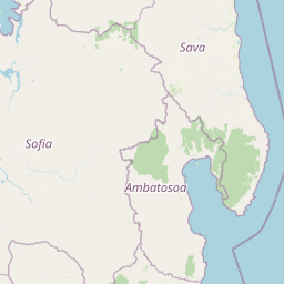
Map view of Manongarivo Special Reserve

Use this park location map to pinpoint Manongarivo Special Reserve in Madagascar, understand its exact geographic position, and read its mapped placement within the surrounding landscape more clearly.

Pigeon | © OpenStreetMap contributors

Location context for Manongarivo Special Reserve

Diana
Park atlas

Compare adjacent rainforest reserves and regional protected landscapes

Other Parks Near Manongarivo Special Reserve and Surrounding Protected Areas

Browsing other parks near Manongarivo Special Reserve reveals connected humid forest habitats and regional conservation zones. Comparing adjacent protected areas provides broader geographic context for northern Madagascar terrain and wildlife distribution.
Nature reserveDiana
About 55 km away#1 closest

East

Réserve naturelle intégrale de Tsaratanana: Highland Massif and Protected Mountain Terrain

High-altitude geography in the Diana region of northern Madagascar

Spanning tens of thousands of hectares, the Réserve naturelle intégrale de Tsaratanana protects the highest mountain terrain in Madagascar. The landscape is defined by the crystalline Vohibory massif, creating a complex topography of deep valleys and dramatic elevation gradients that support endemic primate habitats and montane forest ecosystems.

Area
486.22 km²
Established
1927
IUCN
Ia
National parkMadagascar
About 59 km away#2 closest

North

Nosy Tanikely National Park: Madagascar National Park & Protected Landscape Identity

Mapped geography and regional park context in Madagascar.

Nosy Tanikely National Park is a designated national park in Madagascar, offering a focused entry point for understanding protected land geography. As a key entity within the island's conservation landscape, it provides valuable context for exploring mapped park boundaries and regional geographic features. Discover how this protected area contributes to the broader atlas of Madagascar's natural heritage.

Area
3.41 km²
Established
2011
Relief
Lowland
Climate
Tropical
National parkMadagascar
About 68 km away#3 closest

North

Lokobe National Park: Madagascar's Protected Natural Landscape and Geographic Context

Explore mapped boundaries and regional park geography.

Lokobe National Park is a protected national park situated within Madagascar, an island country recognized globally for its exceptional biodiversity and unique ecosystems. This page offers a detailed, atlas-oriented perspective on Lokobe National Park, focusing on its designation as a protected area, its specific geographic location, and the natural landscape features that define its territory. Users can explore the park's mapped boundaries and understand its contribution to Madagascar's remarkable natural heritage.

Area
15.23 km²
Established
1927
IUCN
II
Climate
Tropical
National parkMadagascar
About 75 km away#4 closest

West

Sahamalaza National Park: A Key National Park and Ramsar Wetland in Madagascar

Explore Madagascar's unique protected landscape and biodiversity hotspot

Sahamalaza National Park is a significant protected area in Madagascar, designated as both a National Park and an internationally important Ramsar Wetland. It protects vital transitional forest ecosystems and extensive coastal wetland habitats, offering a crucial refuge for critically endangered lemur species and migratory birds. The park's unique geography and ecological role provide rich context for understanding Madagascar's celebrated endemic biodiversity and conservation efforts through mapped landscape exploration.

Area
260.35 km²
Established
2007
IUCN
II
Climate
Tropical
A watercolor landscape illustration depicting green bushes and grey, jagged rock formations under a soft pink and yellow sky.
Nature reserveDiana Region
About 131 km away#5 closest

Northeast

Ankarana Special Reserve: A Detailed Geographic Atlas of the Diana Region's Limestone Plateau

Mapping the karst landscape, subterranean rivers, and cliff formations.

Examine the rugged topography of Ankarana Special Reserve, featuring a 25-kilometre-long cliff known as the Wall of Ankarana and 100 kilometres of mapped cave passages. This protected area offers deep insight into Madagascar's geological history and rare endemic lemur habitats within its dense, jagged tsingy ridges.

Area
182 km²
Established
1956
IUCN
IV
Relief
Upland
Wildlife reserveSava
About 140 km away#6 closest

Southeast

Réserve spéciale d'Anjanaharibe-Sud: Geography and Protected Area Landscape Overview

Deep forest terrain and mountain ridges in the Sava region

Situated in northeastern Madagascar, Réserve spéciale d'Anjanaharibe-Sud encompasses dense evergreen forests and steep mountain terrain. This protected area serves as a significant conservation landscape for rare endemic species, providing a high-elevation habitat that climbs dramatically from 500 meters to peaks above 2,000 meters across the Sava region.

Area
182.56 km²
Established
1958
IUCN
IV
Relief
Mountain
Watercolor painting of a mountainous landscape with green vegetation, a body of water, and distant peaks under a light sky
National parkMadagascar
About 155 km away#7 closest

East

Marojejy National Park: A Protected National Park within Madagascar's Unique Geography

Mapped landscape context and regional protected area significance.

Marojejy National Park is a distinct protected area offering rich insights into Madagascar's natural geography. As a national park, its mapped boundaries define a significant landscape that contributes to the island nation's reputation as a biodiversity hotspot. This entry provides essential context for understanding Marojejy National Park's role within the country's protected lands and its value for structured geographic atlas exploration.

Area
555 km²
Established
1998
IUCN
II
Relief
Mountain
Wildlife reserveDiana
About 168 km away#8 closest

Northeast

Réserve spéciale d'Analamerana: Mapped Geography and Protected Karst Ecosystems

Northern Madagascar wilderness and dry forest topography

Navigate the rugged limestone corridors and canyon networks of Réserve spéciale d'Analamerana. This protected area showcases a distinctive dry forest landscape shaped by seasonal tropical climates and serves as a critical habitat for rare endemic species within the Diana region.

Area
347 km²
Established
1956
IUCN
IV
Relief
Upland

Common questions about visiting, size, designation, and location context for Manongarivo Special Reserve

Manongarivo Special Reserve FAQs for park facts, access, geography, and protected area context

Find quick answers about Manongarivo Special Reserve, including protected-area facts, park geography, trail and visitor context, and how the park fits into its surrounding country and regional landscape.
MoriAtlas Explorer

Continue Your Protected Areas Search Across the Global Atlas

Deepen your exploration by continuing the structured search for national parks and protected areas worldwide. Utilize the comprehensive filtering capabilities to compare different conservation landscapes and refine your understanding of global park geography. Discover more about the distribution and characteristics of protected natural areas.

Global natural geography