Mori Atlas logo
Wildlife reserveManyeleti Game Reserve

Analyzing the ecological mosaic and open bushveld boundaries of this iconic wildlife reserve.

Manyeleti Game Reserve: Mapped Geography and Protected Area Identity in Mpumalanga, South Africa

Manyeleti Game Reserve represents a critical protected landscape within the Lowveld of Mpumalanga, South Africa. As a Place of Stars, the reserve encompasses over 22,750 hectares of bushveld savanna that remains unfenced from the neighboring Kruger National Park. This geography facilitates the natural movement of wildlife across a broader conservation complex, creating a continuous wilderness terrain shaped by river systems and woodland mosaics.

Lowveldbushveld savannaGreater Kruger landscapeBig Fiveunfenced reserveprotected area

Manyeleti Game Reserve

Wildlife reserve

Park overview

Structured park overview, official facts, and landscape profile for Manyeleti Game Reserve

Manyeleti Game Reserve park facts, protected area profile, and essential visitor context

Review the core facts for Manyeleti Game Reserve, including designation, size, terrain, visitor scale, habitats, and operating context in one park-focused overview.

About Manyeleti Game Reserve

Manyeleti Game Reserve is a sizable protected area in the South African Lowveld, occupying a strategic position in the eastern corner of Mpumalanga province. Covering more than 22,750 hectares, it lies immediately to the west of the Kruger National Park, with its eastern boundary defined by a fence-free interface that allows wildlife to move between the two reserves as part of a shared ecosystem. To the south lies the Sabi Sand Game Reserve, famous for its leopard sightings, while the Timbavati Game Reserve borders Manyeleti to the northwest, together forming a broader mosaic of conservation land.

Beyond its position within this conservation network, Manyeleti has a distinctive origin story. It was established in 1967, when five former hunting ranches were purchased by the Department of Bantu Affairs and combined into a single reserve. In the apartheid framework, it was designated for the use of Black South Africans, a context that gave the reserve a unique political significance compared with neighboring private and provincial reserves. The Tsonga people, who occupied the land before colonization, were granted visiting rights, and heritage and leadership roles of the Mnisi and Mathebula tribes remain part of the reserve's ongoing story, including contemporary efforts to reclaim land from which communities were forcibly removed.

Ecologically, Manyeleti sits within classic Lowveld bushveld terrain, characterized by a mix of open savanna, tree-savanna, and riverine vegetation. Because it is unfenced along the Kruger boundary, it shares in the broader dynamics of the greater Kruger landscape, supporting populations of large mammals that move across the regional reserve complex. Managed today by the Mpumalanga Provincial Government, Manyeleti functions both as a wildlife conservation area and as a place with deep cultural and historical resonance, where ecology, governance, and community history continue to intersect.

Quick facts and research context for Manyeleti Game Reserve

Manyeleti Game Reserve lies in eastern Mpumalanga, South Africa, near Hoedspruit, and covers over 22,750 hectares of bushveld within the greater Kruger conservation landscape. It is unfenced along its border with Kruger National Park, allowing wildlife to move freely between the two areas, and is flanked by the Sabi Sand and Timbavati reserves.

Established in 1967 from five former hunting ranches, Manyeleti is operated by the Mpumalanga Provincial Government. Its Xitsonga name means 'Place of Stars' and the reserve is notable both ecologically, as part of the broader Lowveld ecosystem, and historically, as a reserve originally designated for use by Black South Africans during the apartheid period, with the Tsonga people continuing to play a role in its land and governance story.

Protection and recognition

Examine the documented conservation framework and formal designation records for Manyeleti Game Reserve.

Manyeleti Game Reserve Protection Status and International Recognition

Review the documented protection status and formal recognition history associated with Manyeleti Game Reserve. Verify official administrative records and international designation details for this protected area.

Protection details

Transboundary protection
No
Park context

Deeper park guide and search-rich context for Manyeleti Game Reserve

Manyeleti Game Reserve history, landscape, wildlife, and travel context

Explore Manyeleti Game Reserve through its history, landscape character, ecosystems, wildlife, conservation priorities, cultural context, and seasonal travel timing in a structured park guide built for atlas discovery and search intent.

Why Manyeleti Game Reserve stands out

Manyeleti is best known as a 'Place of Stars' reserve adjoining the Kruger National Park, forming part of one of South Africa's most important contiguous conservation landscapes. Its unfenced boundary with Kruger allows free movement of large mammals, including the Big Five, across an extensive Lowveld wilderness. The reserve also stands out for its distinctive political and cultural history. Created in 1967 as a game reserve designated for Black South Africans during apartheid, it carries a unique legacy tied to the Tsonga people, traditional leadership structures, and contemporary land restitution processes that continue to shape its identity alongside its wildlife appeal.

Manyeleti Game Reserve history and protected-area timeline

Manyeleti Game Reserve was formally established in 1967, when the South African government, through the Department of Bantu Affairs, acquired and combined five hunting ranches in eastern Mpumalanga into a single protected area. The reserve was shaped by the political conditions of the apartheid era, during which it was designated for the use of Black South Africans, an arrangement intended to address what the government framed as the aspirations of the country's Black population to have a game reserve of their own.

Before colonization, the land that now makes up Manyeleti was occupied by the Tsonga people, and during the reserve's early decades the Tsonga were granted visiting rights rather than full ownership or management roles. The area has continued to be associated with the Mnisi and Mathebula traditional leadership structures. In more recent decades, the Tsonga tribal authorities under these leaders have been engaged in processes aimed at reclaiming land from which communities were historically removed, intertwining the reserve's ecological and political histories.

Today, while the reserve remains managed by the Mpumalanga Provincial Government and operates as a functioning game reserve, its history continues to influence how it is understood. The combination of its apartheid-era origins, its location next to Kruger National Park, and the ongoing cultural claims of the Tsonga communities makes Manyeleti's history an integral part of its identity as a protected area.

Manyeleti Game Reserve landscape and geographic character

Manyeleti's landscape is characteristic of the South African Lowveld, a region defined by a relatively flat to gently undulating terrain that sits at the transition between the escarpment and the Mozambique coastal plain. The reserve falls within an area where open savanna and mixed tree-savanna dominate, with vegetation patterns shaped by seasonal rainfall, river systems, and the ecological influence of the adjacent Kruger National Park.

Because Manyeleti is unfenced along its eastern boundary with Kruger, the reserve forms a continuous landscape with the wider Kruger ecosystem. To its south runs the Sabi Sand Game Reserve, and to its northwest the Timbavati Game Reserve, both of which share similar bushveld terrain. The interplay of grasslands, woodland patches, and riparian strips gives Manyeleti a mosaic appearance typical of this part of Mpumalanga, supporting both resident wildlife and the seasonal movement of animals across the reserve complex.

The skies above this landscape are another defining feature; the name 'Manyeleti', meaning 'Place of Stars' in Xitsonga, reflects the exceptionally clear night skies of the Lowveld, where minimal light pollution reveals densely starred horizons above the bushveld below.

Manyeleti Game Reserve ecosystems, habitats, and plant life

As part of the greater Lowveld ecological system, Manyeleti supports the savanna and bushveld habitats that characterize this part of northeastern South Africa. Its ecosystems share ecological continuity with Kruger National Park, Sabi Sand, and Timbavati, creating an interconnected habitat network rather than an isolated reserve.

The vegetation mix includes open grassland, denser woodland, and riverine vegetation along seasonal watercourses, providing a varied habitat structure that supports a wide range of fauna. This habitat diversity, combined with the absence of internal fencing along the Kruger boundary, allows Manyeleti to function as part of a larger ecological unit, where processes such as predator-prey dynamics, herbivore movement, and seasonal resource use play out across the broader landscape rather than within a single fenced area.

Manyeleti Game Reserve wildlife and species highlights

Manyeleti's wildlife profile is closely tied to that of the greater Kruger ecosystem, with the reserve benefiting from its open boundary with Kruger National Park. Large mammals characteristic of the Lowveld, including members of the Big Five group, move across this landscape, taking advantage of the contiguous habitat provided by the multiple adjoining reserves.

The mix of open savanna, woodland, and riparian zones creates conditions for varied predator and prey interactions, and supports a typical Lowveld mammal community that includes grazers and browsers suited to mixed bushveld vegetation. The reserve's connectedness with Sabi Sand and Timbavati further enhances its role as part of a regional wildlife system rather than a standalone conservation area.

Manyeleti Game Reserve conservation status and protection priorities

Manyeleti contributes meaningfully to conservation through its role within the broader Kruger conservation landscape. Its unfenced boundary with Kruger National Park allows for free movement of large mammals and helps maintain ecological processes across a wide area, increasing the effective size and resilience of habitat available to species that require extensive ranges.

Alongside Sabi Sand and Timbavati, Manyeleti forms part of a multi-reserve network that is among the most important for large-mammal conservation in South Africa. While the reserve is managed by the Mpumalanga Provincial Government rather than by a private or community trust, its position in this network gives it conservation value well beyond its individual area, supporting regional biodiversity, predator populations, and the long-term ecological functioning of the Lowveld.

Manyeleti Game Reserve cultural meaning and human context

The cultural context of Manyeleti is integral to its identity. The reserve's Xitsonga name, meaning 'Place of Stars', reflects the linguistic heritage of the Tsonga people, who occupied the land prior to colonization and have maintained traditional leadership structures in the area, particularly through the Mnisi and Mathebula tribal authorities.

The political circumstances of the reserve's establishment in 1967, when it was created as a reserve for Black South Africans under apartheid, gave Manyeleti a distinctive cultural and political history shared by few other South African game reserves. In more recent times, the Tsonga communities have continued to engage with the land through ongoing land restitution processes, making Manyeleti a place where contemporary conservation, traditional authority, and post-apartheid land questions intersect.

Top sights and standout views in Manyeleti Game Reserve

Manyeleti's standout qualities include its position as a 'Place of Stars' reserve adjoining Kruger National Park, its unfenced ecological connection with Sabi Sand and Timbavati, and its distinctive origins as a reserve designated for Black South Africans in 1967. Together, these features give it a combination of ecological, cultural, and historical significance that distinguishes it from many neighboring Lowveld reserves.

Best time to visit Manyeleti Game Reserve

Manyeleti lies in the South African Lowveld, where the dry winter months from roughly May to August typically bring cooler temperatures, clearer skies, and more open visibility around waterholes, while the wetter summer months from November to March bring lush vegetation, peak bird activity, and warmer conditions with afternoon thunderstorms. Wildlife viewing is rewarding across the year, with the dry season often favoring mammal sightings near water and the wet season offering a greener landscape and active birdlife under the same 'Place of Stars' skies that give the reserve its name.
Monthly climate preview

Long-term temperature ranges and monthly precipitation averages for regional terrain

Manyeleti Game Reserve Climate Normals and Annual Weather Patterns

Historical climate data for Manyeleti Game Reserve shows distinct annual variations in monthly temperature and precipitation recorded at representative coordinates. Detailed records provide twelve-month averages for maximum temperatures, minimum thresholds, and daily rainfall totals across the protected landscape.
Annual mean22 °C
17 °C25 °C
Jan25°
Feb25°
Mar24°
Apr22°
May19°
Jun17°
Jul17°
Aug19°
Sep22°
Oct23°
Nov25°
Dec25°
Warmest month
December

25.3 °C

Coolest month
July

16.8 °C

Wettest month
January

3.9 mm/day

Driest month
June

0.3 mm/day

Park location guide

Geography guide, regional context, and park location map for Manyeleti Game Reserve

Manyeleti Game Reserve park geography, regions, and map view in South Africa

Understand where Manyeleti Game Reserve sits in South Africa through a broader geographic reading of the surrounding landscape, nearby location context, and its mapped position within the national park landscape.

How Manyeleti Game Reserve fits into South Africa

South Africa is the southernmost country in Africa, spanning 1.22 million km² with a population of over 63 million. The country operates with three capital cities, Pretoria (executive), Cape Town (legislative), and Bloemfontein (judicial), and is renowned for its biodiversity, national parks, and multicultural society.

Wider geography shaping Manyeleti Game Reserve in South Africa

South Africa occupies the southernmost region of Africa, with coastline along both the Atlantic Ocean to the west and the Indian Ocean to the east. The interior features elevated plateaus including the Highveld, with the Drakensberg escarpment marking the eastern highlands. The country shares borders with Namibia, Botswana, Zimbabwe, Mozambique, Eswatini, and Lesotho.

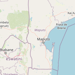
Map view of Manyeleti Game Reserve

Use this park location map to pinpoint Manyeleti Game Reserve in South Africa, understand its exact geographic position, and read its mapped placement within the surrounding landscape more clearly.

Pigeon | © OpenStreetMap contributors

Location context for Manyeleti Game Reserve

Mpumalanga
Park atlas

Compare surrounding Lowveld reserves and contiguous conservation areas

Parks Near Manyeleti Game Reserve and Connected Protected Landscapes

Browse protected areas and adjacent wildlife reserves situated directly around Manyeleti Game Reserve in the South African Lowveld. Comparing these neighboring habitats reveals the continuous ecological structure and shared savanna terrain of the greater regional park network.
National parkSouth Africa
About 5.8 km away#1 closest

North

Kruger National Park: South Africa's Iconic National Park for Geographic Discovery

Explore savanna landscapes and mapped protected area boundaries.

Kruger National Park serves as a paramount example of a protected landscape, offering a rich tapestry of savanna ecosystems and varied terrain across South Africa's Lowveld. This canonical entry details its vast geographic scope, approximately 19,623 square kilometres, and its status as the nation's first national park. Understand the park's environmental context, from the Lebombo Mountains to the Limpopo River, and its integral role within larger transfrontier conservation initiatives, providing critical insight for atlas-based geographic exploration.

Area
19,623 km²
Established
1926
IUCN
II
Visitors
1.7M annual
Wildlife reserveMpumalanga
About 22 km away#2 closest

Southeast

Sabi Sand Game Reserve: Geographic Atlas and Protected Landscape Mapping in Mpumalanga

Mapping riparian corridors and savanna ecosystems in eastern South Africa

Sabi Sand Game Reserve provides a foundational study in private conservation landscapes, situated within the Lowveld of Mpumalanga. The reserve is uniquely defined by the Sand and Sabie Rivers, which sculpt the local terrain and support diverse riparian habitats. This atlas-focused entry examines the reserve as a complex, unfenced entity adjacent to Kruger National Park, highlighting its role in regional conservation geography and the spatial distribution of its renowned private concessions.

Area
650 km²
Established
1948
Relief
Lowland
Climate
Subtropical
Wildlife reserveLimpopo
About 32 km away#3 closest

West

Thornybush Game Reserve: A Protected Wildlife Landscape in Limpopo, South Africa

Mapped savanna corridors and riverine ecological zones

Located in the Limpopo province of South Africa, Thornybush Game Reserve is an essential private wildlife area known for its open savanna and rich riparian vegetation. By maintaining an unfenced boundary with the neighboring national park, it acts as a critical extension of the Greater Kruger wilderness. This entry details its geographical scope, terrain features, and its function as a managed, integrated component of the regional conservation landscape.

Area
140 km²
Water
Minor water
Nature reserveMpumalanga
About 34 km away#4 closest

North

Timbavati Private Nature Reserve: Protected Landscape and Regional Map Overview

Savanna bushveld geography in Mpumalanga, South Africa

Spanning over 534 square kilometres, Timbavati Private Nature Reserve provides a crucial habitat mosaic within the Mpumalanga region. The area is defined by its pioneering unfenced conservation model, linking private land with the Greater Kruger National Park to protect a broad spectrum of woodland habitats and diverse savanna ecosystems.

Area
534 km²
Established
1956
Relief
Upland
Climate
Subtropical
Wildlife reserveLimpopo
About 46 km away#5 closest

Northwest

Kapama Game Reserve: Geographic Atlas and Protected Landscape Map of Limpopo

Explore the diverse terrain and riverine ecosystems of this South African wildlife reserve

Kapama Game Reserve sits within the Limpopo Lowveld, featuring a complex mix of open savanna, mixed bushveld, and dense riverine corridors shaped by the Blyde River. This record provides a detailed look at the reserve as a functional piece of the greater regional conservation landscape, highlighting its topography and its role in protecting South Africa's native habitat.

Area
130 km²
Established
1993
Scope
Terrestrial
A horizontal watercolor painting depicting the Blyde River Canyon with green slopes, reddish cliff faces, and a winding river.
Nature reserveMpumalanga
About 64 km away#6 closest

West

Blyde River Canyon Nature Reserve: Escarpment Geography and Protected Landscape Map

Mapping river-carved canyons and plateau ecosystems in Mpumalanga

Blyde River Canyon Nature Reserve protects a vast stretch of the Mpumalanga Drakensberg, characterized by vertical cliffs, rocky massifs, and deep river gorges. This atlas-focused resource highlights the reserve's geological landmarks, including the Three Rondavels and Bourke's Luck Potholes, offering a clear view of the complex terrain and protected natural boundaries defining this northeastern South African landscape.

Area
290 km²
Established
1965
Relief
Mountain
Climate
Subtropical
Nature reserveLimpopo
About 71 km away#7 closest

Northwest

Balule Nature Reserve: Mapping the Protected Lowveld Savannah and Olifants River Corridor

An open-system wilderness integral to the Greater Kruger ecological network.

Explore the geographic identity of Balule Nature Reserve, a vast protected area in South Africa characterized by its integration with the Greater Kruger wilderness. The terrain encompasses a rich mix of mopane-dominated woodland, riverine forest along the Olifants River, and open subtropical bushveld that supports significant wildlife migrations.

Area
400 km²
Relief
Lowland
Climate
Subtropical
Access
Moderate access
A soft watercolor illustration showing rolling green hills with sparse native vegetation, set against a pale, warm-toned horizon.
Biosphere reserveLimpopo
About 71 km away#8 closest

Northwest

Kruger to Canyons Biosphere: An Atlas of Protected Lands and Geographic Diversity in Limpopo

Integrated conservation across savanna, canyon, and montane ecosystems

Covering the stretch between the Letaba and Sabie Rivers, this biosphere reserve serves as a vital conservation landscape in South Africa. Its unique geography captures the transition from rugged escarpment cliffs to open bushveld, showcasing a high density of protected land and biodiversity. Use this map-oriented resource to understand the structural role of the biosphere as a model for landscape-scale environmental management and its geographic placement within the Limpopo province.

Area
28,748.1 km²
Established
2001
Relief
Mixed relief
Access
Access unknown

Common questions about visiting, size, designation, and location context for Manyeleti Game Reserve

Manyeleti Game Reserve FAQs for park facts, access, geography, and protected area context

Find quick answers about Manyeleti Game Reserve, including protected-area facts, park geography, trail and visitor context, and how the park fits into its surrounding country and regional landscape.
MoriAtlas Explorer

Continue Your Protected Areas Search Across the Global Atlas

Deepen your exploration by continuing the structured search for national parks and protected areas worldwide. Utilize the comprehensive filtering capabilities to compare different conservation landscapes and refine your understanding of global park geography. Discover more about the distribution and characteristics of protected natural areas.

Global natural geography