
Mori Atlas logo
Nature reserveMariannenaue

Mapping the floodplain forest, vineyard agriculture, and still-water channels of a unique inland island.

Mariannenaue Nature Reserve: A Protected Rhine Island Landscape in Hessen, Germany

Mariannenaue stands as one of the significant protected river islands in the Upper Rhine valley of Hessen. This nature reserve, spanning over sixty-eight hectares, features a distinctive geography defined by ancient Auenwald floodplain forests and calm side channels including the Kleine Gieß and Große Gieß. Beyond its ecological role as a vital habitat for migratory birds and rare species, the island functions as a historic viticultural landscape where calcareous alluvial soils support active wine production.

Rhine islandinland islandnature reserveFFH areafloodplain forestAuenwald
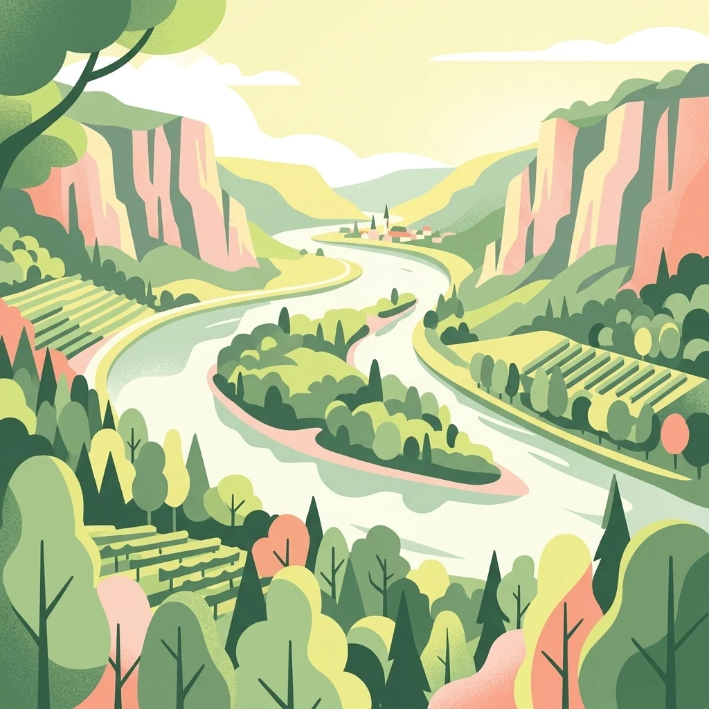
A stylized digital illustration of a river landscape with a central island covered in dense forest. Steep valley slopes on both sides of the river feature terraced vineyards and woodland areas under a soft, warm sky.

Mariannenaue

Nature reserve

Park overview

Structured park overview, official facts, and landscape profile for Mariannenaue

Mariannenaue park facts, protected area profile, and essential visitor context

Review the core facts for Mariannenaue, including designation, size, terrain, visitor scale, habitats, and operating context in one park-focused overview.

About Mariannenaue

Mariannenaue is a sizeable inland island in the Upper Rhine, lying between the districts of Erbach and Hattenheim in the Rheingau. Administratively it belongs to the borough of Eltville am Rhein in Hesse, and with roughly 68 hectares of island surface it exceeds the size of the much better-known Mainau in Lake Constance. Including the long training groynes that extend along both sides of the main navigation channel, the island and its associated works stretch for more than five kilometers along the river.

The island sits between two branches of the Rhine, the Kleine Gieß to the north and the Große Gieß to the south, which together form a network of calmer, still-water zones that are ecologically as important as the island itself. Together, the island and its surrounding groynes and still waters constitute a legally protected nature reserve and a European-level FFH area under the EU Habitats Directive.

Mariannenaue is notable for combining ecological, agricultural, and cultural-historical significance within a single compact river island. It shelters old Auenwald forest, serves as a breeding and staging site for waterbirds, hosts one of the more unusual wine estates of the Rheingau, and remains tied to the history of Schloss Reinhartshausen on the right bank of the Rhine.

Quick facts and research context for Mariannenaue

Mariannenaue is a protected inland island in the Upper Rhine, located in the Rheingau between Erbach and Hattenheim within the borough of Eltville am Rhein, Hesse. It carries an official German nature reserve designation dating from 1972 and is simultaneously part of the European FFH network since 1974. The island is larger than the better-known Mainau and is framed by the two still-water channels called the Kleine Gieß and Große Gieß. Much of its surface is actively farmed as vineyards by the estate of Schloss Reinhartshausen, while the remainder is occupied by old Auenwald forest and protected bird habitat.

Protection and recognition

Documented terrestrial designation history and Natura 2000 records

Mariannenaue Protection Status and International Recognition Data

Mariannenaue holds an established terrestrial protection status dating from 1974 alongside verified Natura 2000 recognition records. Structured atlas entries compile official designation history and management scope for protected area analysis.

International recognition

Protection details

Protection scope
Terrestrial
Designated year
1974
Transboundary protection
No
Park context

Deeper park guide and search-rich context for Mariannenaue

Mariannenaue history, landscape, wildlife, and travel context

Explore Mariannenaue through its history, landscape character, ecosystems, wildlife, conservation priorities, cultural context, and seasonal travel timing in a structured park guide built for atlas discovery and search intent.

Why Mariannenaue stands out

Mariannenaue is best known as a protected Rhine island in the Rheingau, distinguished by its Auenwald floodplain forests with veteran trees up to four centuries old, its importance for breeding and migratory waterbirds, and its cultivated vineyards of Schloss Reinhartshausen that occupy almost the entire island surface.
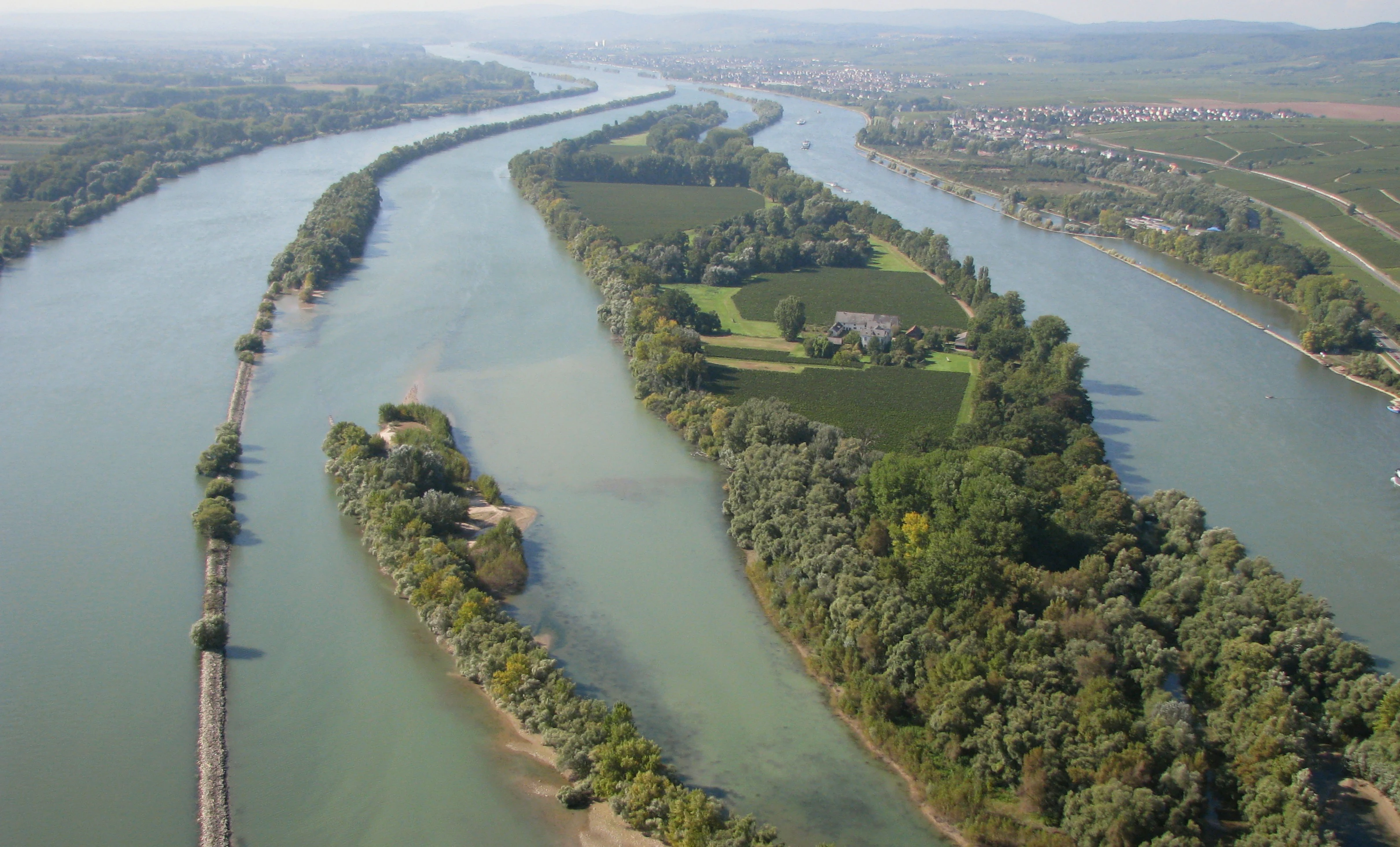
An aerial shot looking down the Rhine river, featuring the long green island of Mariannenaue surrounded by river channels, with agricultural fields and trees visible on the island.
An aerial view of the Mariannenaue island situated in the Rhine river.

Mariannenaue history and protected-area timeline

Mariannenaue originally existed as two separate islands, both formed roughly 10,000 years ago from calcareous sediments carried down from the Alps by the Rhine. The islands merged naturally in the 18th century through ongoing sedimentation, and the faint boundary depression, still lined with floodplain forest, is visible across the surface today.

The eastern, smaller parcel had belonged from early times to the knightly estate that later became Schloss Reinhartshausen. The much larger western parcel, known as the Hattenheimer Aue, had been held by the Langwerth von Simmern family since 1464 and was historically administered under the Ingelheim knightly court before being reassigned, after long legal disputes, to the Rheingau in the 18th century. Some local historians have suggested that this same island is the place where Emperor Louis the Pious died in the year 840, opposite Ingelheim.

In 1800 Count Clemens August von Westphalen acquired both island portions together with Schloss Reinhartshausen. He unified them under the name Westfälische Aue and laid out a landscape park aligned with the schloss. In 1902 the island was renamed Mariannenaue in honor of Princess Marianne of Orange-Nassau, who had owned the schloss from 1855 and lived there until her death in 1883.

Mariannenaue landscape and geographic character

Mariannenaue is a low, elongated river island that hugs the right bank of the Upper Rhine for several kilometers between Erbach and Hattenheim. Its surface is essentially flat, built from calcareous alluvium deposited by the Rhine over millennia, and its widest point reaches about 300 meters. A long depression runs diagonally across the island, marking where two former islands merged and where floodplain forest still grows.

The island is framed by active river flow on one side and still-water channels on the other. The Große Gieß to the south and the Kleine Gieß to the north create sheltered, near-static waters that widen the effective ecological footprint well beyond the dry land of the island itself. Long training groynes extending downstream from Eltville to Oestrich-Winkel shape the riverbed around the island and reinforce this contrast between moving and calm water that defines the local landscape character.
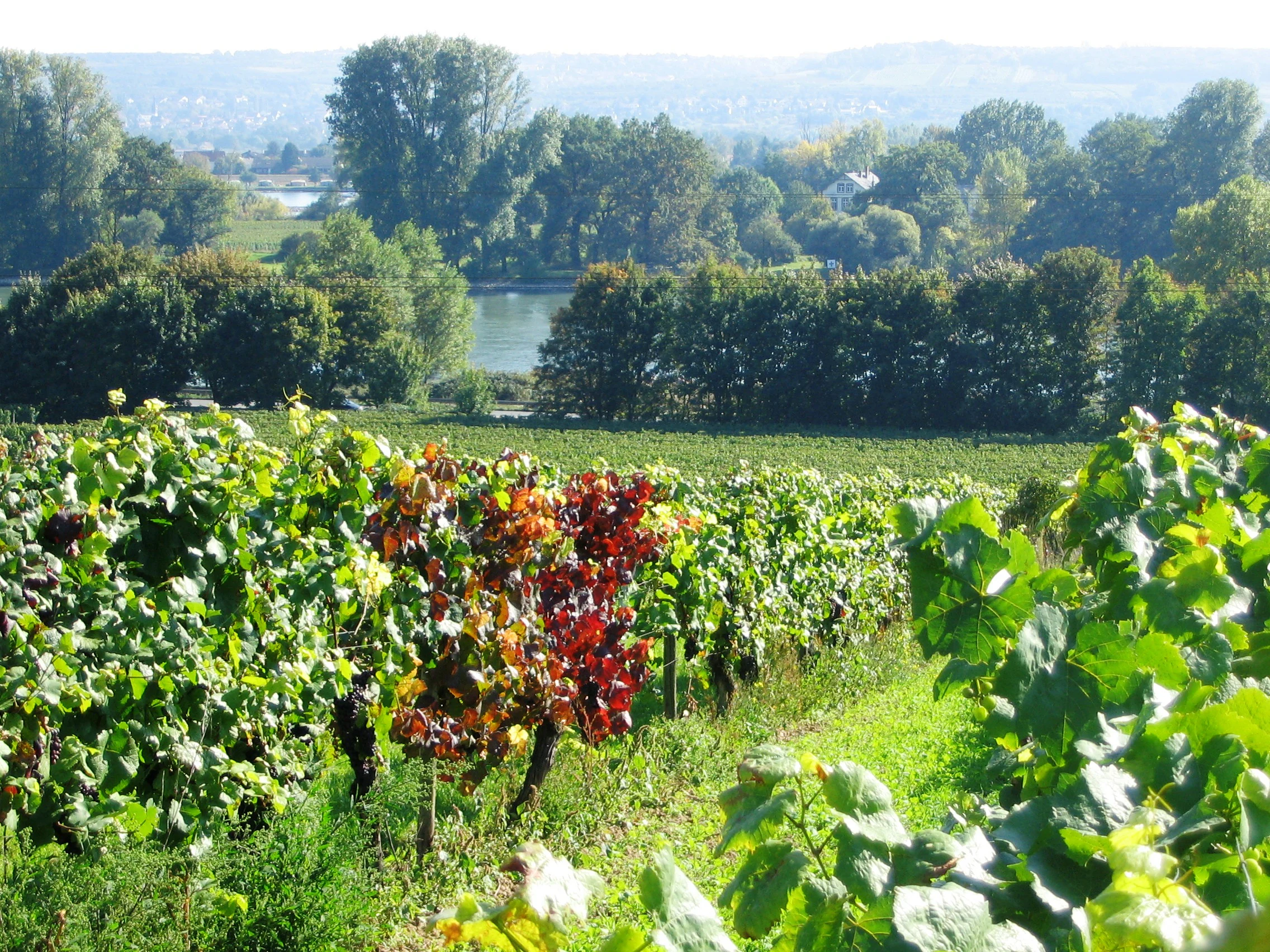
Vineyards in the foreground with rows of grapevines showing early autumn colors, looking toward the tree-lined banks of the Rhine river and Mariannenaue island in the background.
A view of the Mariannenaue island in the Rhine river, seen from the surrounding vineyards near Erbach.

Mariannenaue ecosystems, habitats, and plant life

The ecological character of Mariannenaue is shaped by the coexistence of floodplain forest, riverbank habitat, and the still waters of the surrounding Gießen. The Auenwald contains very old trees, with some individuals estimated at up to four hundred years, making the forest one of the more notable veteran-tree habitats along this stretch of the Rhine.

The combination of sheltered waters, wooded banks, and exposed gravel areas provides nesting and feeding conditions for a range of bird species, and the island functions both as a breeding ground and as a resting and overwintering area for migratory birds. Mammals recorded on the island include a rare beaver species. Roe deer and wild boar regularly cross the river to and from the island, with the result that population dynamics on land and on the island cannot be considered in isolation.
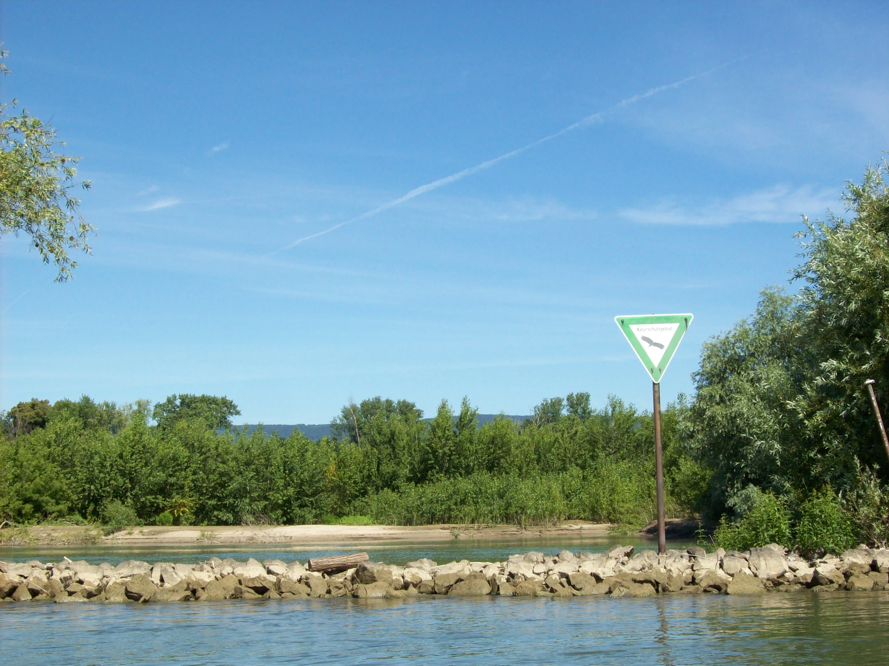
A wide view of a river bank with a lush, green forest on the island of Mariannenaue, a sandy shore, and a triangular nature reserve sign in the foreground.
View of the Mariannenaue nature reserve from the river, featuring a characteristic German nature reserve sign.

Mariannenaue wildlife and species highlights

Mariannenaue supports a distinctive island river fauna shaped by its mix of forest, still water, and exposed riverbank. The island is recorded as a breeding area for cormorants, grey herons, and black kites, and it functions as a resting and overwintering site for numerous migratory bird species moving along the Rhine corridor. A rare beaver species is documented as resident on the island.

On the larger mammal side, roe deer and wild boar are actively hunted here, and the river itself acts as a regular crossing route; animals swim from the mainland on either side to reach the island and back, so the population is not isolated. This openness is also ecologically consequential: in late 2024 cases of African swine fever were confirmed in wild boar on the island and on the adjacent right-bank mainland between Erbach and Hattenheim, illustrating how tightly the island's wildlife dynamics are tied to those of the surrounding Rheingau land.

Mariannenaue conservation status and protection priorities

The island and its surrounding groynes and still water zones have been a designated nature reserve (Naturschutzgebiet) since November 1972. Since 1974 it has been recognized as a European nature reserve and a Fauna-Flora-Habitat (FFH) area under the EU Habitats Directive, giving it formal transboundary ecological status that connects it to broader European habitat networks along the Upper Rhine.

Mariannenaue cultural meaning and human context

The island has long been embedded in the wine-growing and noble estate culture of the Rheingau. Schloss Reinhartshausen on the right bank acquired and unified the two former island parts in 1800, creating a landscape park oriented toward the schloss, and the island was subsequently renamed after Princess Marianne of Orange-Nassau, who made the schloss her residence from 1855 until 1883. The vineyards today are part of the historic Rheingau wine tradition, with named sites including Erbacher Rheinhell and Hattenheimer Rheingarten.

Top sights and standout views in Mariannenaue

Highlights of Mariannenaue include its setting as one of the larger Rhine islands in the Upper Rhine valley, the old Auenwald forests running diagonally across the island where two former islands once merged, the protected still waters of the Kleine Gieß and Große Gieß on either side, the bird breeding and resting colonies along the river, and the unusual agricultural character of a wine estate that has operated continuously on a river island for centuries.

Best time to visit Mariannenaue

Spring and early summer bring the most vivid vegetation and active birdlife, while autumn is the period of grape harvest on the island. The surrounding flowing river water moderates temperatures through the year, so summer heat is softened, but visitors should note that access is only possible as part of guided tours and that the still waters around the island are seasonally closed to boats, generally between autumn and early spring.


Monthly climate preview

Long term representative point averages for monthly temperature and precipitation rhythm

Mariannenaue Climate Normals and Measured Annual Temperature Patterns

Long term measurements for Mariannenaue outline a structured annual cycle of recorded average temperatures and precipitation rates from representative coordinate data. Reviewing the complete twelve month profile clarifies detailed monthly shifts across the protected landscape.
Annual mean9 °C
0 °C20 °C
Jan
Feb
Mar
Apr
May13°
Jun17°
Jul20°
Aug19°
Sep15°
Oct
Nov
Dec
Warmest month
July

19.6 °C

Coolest month
January

-0.1 °C

Wettest month
July

2.2 mm/day

Driest month
April

1.5 mm/day

Park location guide

Geography guide, regional context, and park location map for Mariannenaue

Mariannenaue park geography, regions, and map view in Germany

Understand where Mariannenaue sits in Germany through a broader geographic reading of the surrounding landscape, nearby location context, and its mapped position within the national park landscape.

How Mariannenaue fits into Germany

Germany is a federal republic in Western and Central Europe with a population of over 83 million across sixteen constituent states. It is Europe's largest economy by nominal GDP and a major global exporter and importer. The capital is Berlin, and the country borders Denmark, Poland, Czech Republic, Austria, Switzerland, France, Luxembourg, Belgium, and the Netherlands.

Wider geography shaping Mariannenaue in Germany

Germany is located in Western and Central Europe, spanning 357,022 km². It borders Denmark to the north, Poland and the Czech Republic to the east, Austria and Switzerland to the south, and France, Luxembourg, Belgium, and the Netherlands to the west. The country has coastlines on the Baltic Sea and North Sea to the north, with the Alps located in the southern region.

Map view of Mariannenaue

Use this park location map to pinpoint Mariannenaue in Germany, understand its exact geographic position, and read its mapped placement within the surrounding landscape more clearly.

Pigeon | © OpenStreetMap contributors

Location context for Mariannenaue

Hessen
Recorded earthquake history

Explore the Historical Record of Earthquakes Near Mariannenaue

Browse the documented seismic history associated with the coordinates of this Upper Rhine nature reserve. This catalogue serves as a reliable reference for recorded events and regional seismic patterns, helping users explore the geographic context of Mariannenaue through the lens of historical geological data.

Mariannenaue Earthquake History

Catalogued events

36 events

Strongest magnitude

Magnitude 4.3

Most recent event

May 17, 2014

This history includes earthquakes recorded inside the park or within 50 km of its borders

Visual reference for floodplain forests, river channels, and island habitats

Mariannenaue Photos and Protected Landscape Scenery in the Upper Rhine

Visual documentation captures the distinctive terrain, Auenwald floodplain forests, and quiet side channels defining Mariannenaue across the Upper Rhine valley. Examining protected area imagery provides a clear understanding of the river island geography, rare habitats, and conservation landscape character.

An aerial shot looking down the Rhine river, featuring the long green island of Mariannenaue surrounded by river channels, with agricultural fields and trees visible on the island.

An aerial view of the Rhine river featuring the forested Mariannenaue island on the left and the town of Erbach on the right bank.

Vineyards in the foreground with rows of grapevines showing early autumn colors, looking toward the tree-lined banks of the Rhine river and Mariannenaue island in the background.

A wide view of a river bank with a lush, green forest on the island of Mariannenaue, a sandy shore, and a triangular nature reserve sign in the foreground.

Park atlas

Compare adjacent river landscapes and regional floodplain reserves

Explore Protected Areas and Parks Near Mariannenaue in the Upper Rhine Valley

Browsing parks near Mariannenaue reveals connected floodplain forests, wetland habitats, and protected reserves throughout the Upper Rhine valley. Expanding the geographic comparison provides deeper insight into regional conservation networks and riverine ecosystems.
A watercolor painting showing a soft, atmospheric landscape with a river flowing through green hills and gentle, misty mountains.
Nature reserveRhineland-Palatinate
Park boundaries overlap#1 closest

East

Inselrhein Nature Reserve, Rhineland-Palatinate: A Geographic and Protected-Area Atlas

River islands, floodplain forests, and Upper Rhine wetlands

Inselrhein features a chain of natural river islands and side channels forming a critical wetland habitat. The terrain transition from soft-wood to hardwood forest communities creates a layered landscape. Examine the protected boundaries and geographic significance of this river corridor between Mainz and Bingen, documented within the Rhineland-Palatinate atlas.

Relief
Lowland
Climate
Temperate
Access
Easy access
Scope
Terrestrial
A horizontal watercolor illustration of a natural landscape featuring a small body of water or pond in the foreground, surrounded by grassy banks, low hills in the distance, and soft-colored vegetation.
Nature reserveRhineland-Palatinate
About 2 km away#2 closest

Southeast

Sandgrube am Weilersberg Nature Reserve and Protected Landscape Map

Rhineland-Palatinate, Germany protected area

Sandgrube am Weilersberg is a protected nature reserve in Rhineland-Palatinate, Germany, known for its compact mosaic of calcareous sand slopes and wet meadows. Part of the Natura 2000 network, the site preserves rare steppe flora and wetland ecosystems that emerged following former sand extraction. The terrain supports significant entomological, botanical, and bryological diversity maintained through active grazing.

Area
0.095 km²
Established
1986
Relief
Lowland
Climate
Temperate
Nature reserveRhineland-Palatinate
About 2.7 km away#3 closest

South

Hangflächen um den Heidesheimer Weg: Nature Reserve Geography and Protected Landscape Context

Mainz-Bingen, Rhineland-Palatinate Nature Reserve

Hangflächen um den Heidesheimer Weg contains an unusual ecological convergence of sand dunes, open flats, and calcareous grasslands near Ingelheim am Rhein. This nature reserve provides critical protection for a fragmented yet highly structured landscape where springs and wetland zones intersect with warm, dry slopes. The area preserves a significant biotope complex of national importance within the Upper Rhine Plain.

Area
3.348 km²
Established
2003
A soft watercolor painting of a forest landscape with slender trees, green grass, and distant rolling hills against a pale, warm sky.
Nature reserveRhineland-Palatinate
About 5.3 km away#4 closest

East

Lennebergwald Nature Reserve: Mapped Geography and Protected Forest Landscapes in Germany

Rhineland-Palatinate woodland and dry forest ecosystem analysis

Analyze the Lennebergwald nature reserve through its geological and ecological profile. This protected area in Rhineland-Palatinate showcases a rare inland sand forest structure, linking together pine and oak stands with vital dry grassland habitats that form a critical ecological mosaic in central Germany.

Area
8 km²
Established
1996
Relief
Lowland
Climate
Temperate
Watercolor painting of a misty river landscape with green trees, reeds, and soft hills in the background.
Nature reserveHesse
About 5.4 km away#5 closest

Northeast

Niederwallufer Bucht Nature Reserve: Rhine Floodplain Landscape and Geographic Context

Protected riparian habitat in the state of Hesse

Niederwallufer Bucht represents a key example of a conserved Rhine riverbank environment. This nature reserve protects a delicate mix of soft-wood forests, sheltered backwater bays, and riparian meadows. By maintaining these wetlands against the backdrop of the heavily settled Rheingau, the site provides a vital node of ecological continuity and a clear look at floodplain terrain within central Germany.

Area
0.13 km²
Established
2000
IUCN
IV
A watercolor illustration of a calm body of water with a single tree in the center; distant rolling hills are visible in the background under a soft, pastel-colored sky.
Nature reserveLower Saxony
About 6.4 km away#6 closest

Southwest

Fulder Aue, Ilmen Aue Nature Reserve: Mapped Protected Landscapes and Floodplain Geography

Alluvial river islands and wetland ecosystems in the Rhine valley.

The Fulder Aue, Ilmen Aue nature reserve serves as an vital example of an active Rhine floodplain. This area preserves a mosaic of islands, connecting channels, and soft-wood forest habitats. Learn about the geographic and hydrological dynamics that shape this protected space near Bingen am Rhein, showcasing its importance within the Rhine lowland system.

Area
3.38 km²
Established
1995
Relief
Lowland
Scope
Terrestrial
Watercolor painting of a river landscape with rolling green hills, distant slopes, and soft vegetation in shades of green and pink against a white background.
Nature reserveRheingau-Taunus-Kreis
7.6 km away#7 closest

West

Rüdesheimer Aue Nature Reserve and Upper Rhine Protected Landscape

Riverine geography and protected floodplain forest

Rüdesheimer Aue represents a rare, uninhabited island refuge along the Upper Rhine. Its geography features shifting sediment bars, mudflats, and softwood floodplain forest cover, offering an essential staging ground for migratory waterbirds within the Rheingau-Taunus district of Hesse.

Area
0.057 km²
Relief
Lowland
Climate
Temperate
Access
Remote access
A horizontal watercolor illustration of a natural valley scene, featuring an open meadow in the foreground, forest edges in the midground, and rolling hills in the background.
Nature reserveHesse
About 7.7 km away#8 closest

Northeast

Rechtebachtal bei Georgenborn Nature Reserve: Geographic Profile and Protected Landscape

A mapped stream valley ecosystem in the Hesse Taunus foothills

The Rechtebachtal bei Georgenborn nature reserve protects a two-part valley corridor along the Rechtebach stream near Georgenborn and Martinsthal. This site preserves rare habitat mosaics of meadows and woodland that characterize the transitional zone between the Taunus highlands and the Rhine valley, offering a distinct study in regional conservation geography.

Area
0.185 km²
Established
1989
IUCN
IV
Relief
Upland

Common questions about visiting, size, designation, and location context for Mariannenaue

Mariannenaue FAQs for park facts, access, geography, and protected area context

Find quick answers about Mariannenaue, including protected-area facts, park geography, trail and visitor context, and how the park fits into its surrounding country and regional landscape.
MoriAtlas Explorer

Continue Your Protected Areas Search Across the Global Atlas

Deepen your exploration by continuing the structured search for national parks and protected areas worldwide. Utilize the comprehensive filtering capabilities to compare different conservation landscapes and refine your understanding of global park geography. Discover more about the distribution and characteristics of protected natural areas.

Global natural geography