Mori Atlas logo
Wildlife reserveMarinduque Wildlife Sanctuary

Geographic boundaries and forest terrain within the central Marinduque landscape.

Marinduque Wildlife Sanctuary: Exploring the Protected Interior of Marinduque Island

Marinduque Wildlife Sanctuary serves as a crucial protected landscape in the central interior of the Philippines. Spanning roughly 8,800 hectares of rolling forested terrain, this reserve preserves vital habitat for endemic species while acting as a key watershed for the surrounding island. Its remote position north of the dormant Mount Malindig makes it a central pillar of conservation within the MIMAROPA region.

wildlife sanctuaryPhilippine endemic specieslowland forestKey Biodiversity AreaBirdLife International siteMIMAROPA region

Marinduque Wildlife Sanctuary

Wildlife reserve

Park overview

Structured park overview, official facts, and landscape profile for Marinduque Wildlife Sanctuary

Marinduque Wildlife Sanctuary park facts, protected area profile, and essential visitor context

Review the core facts for Marinduque Wildlife Sanctuary, including designation, size, terrain, visitor scale, habitats, and operating context in one park-focused overview.

About Marinduque Wildlife Sanctuary

Marinduque Wildlife Sanctuary occupies a substantial portion of the interior of Marinduque, a heart-shaped island province lying south of Luzon in the Philippines. Established as a national government protected area in 2004 and listed under the NIPAS framework that governs the country's system of prioritized conservation zones, the sanctuary reflects an effort to safeguard the forested interior of an island otherwise known more for coastal communities, traditional festivals, and a long history of human settlement.

The reserve covers approximately 8,827 hectares of gently rolling upland terrain, rising modestly from the western and eastern coastal lowlands toward the island's interior watershed. It lies north of Mount Malindig, the island's most prominent volcanic landform, which rises to over 1,100 meters. The sanctuary's position away from the coast and away from the island's populated lowlands gives it a particular ecological value: it preserves a connected block of forest that buffers watersheds and supports native wildlife in a landscape that has otherwise been heavily altered by agriculture and rural development.

Ecologically, the sanctuary belongs to the broader biogeographic region shared with Luzon and the larger Philippine archipelago, and its forests are characteristic of the country's tropical lowland and submontane forest formations. Marinduque has long been recognized by ornithologists and conservation organizations as an area of significance for Philippine endemic birdlife, and BirdLife International identifies the central portion of the island, including this sanctuary, as a Key Biodiversity Area.

The sanctuary's relative isolation is one of its defining features. No paved roads penetrate its interior, and access requires travel on foot or via rough tracks from the surrounding municipalities of Boac, Gasan, Buenavista, Santa Cruz, and Torrijos. While this limits public visitation and tourism infrastructure, it also shields the area from many of the immediate pressures faced by more accessible Philippine reserves, such as heavy recreational use or roadside development.

Quick facts and research context for Marinduque Wildlife Sanctuary

Marinduque Wildlife Sanctuary is a forest reserve on Marinduque Island in the central Philippines, established on 17 August 2004 through Presidential Proclamation 696 and placed under the NIPAS Act. It covers approximately 8,827 hectares of gently rolling upland terrain, lying inland and north of the extinct volcano Mount Malindig.

The sanctuary's territory extends across the municipalities of Boac, Gasan, Buenavista, Santa Cruz, and Torrijos. Climate type IV applies to the area, with a dry season from January to May and a wet period from June to November that can bring heavy rainfall, averaging around 2,030 millimeters per year. The site supports endemic Philippine species, including the Philippine Duck, several endemic bats, and the large Slender-tailed Cloud Rat, and is recognized as a Key Biodiversity Area by BirdLife International.

Protection and recognition

Examine documented terrestrial protection parameters and official designation records

Marinduque Wildlife Sanctuary Protection Status and Conservation Recognition

Marinduque Wildlife Sanctuary maintains a documented terrestrial protection status within the regional conservation network. Structured facts outline the recorded management scope and international recognition parameters associated with this protected area.

Protection details

Protection scope
Terrestrial
Transboundary protection
No
Park context

Deeper park guide and search-rich context for Marinduque Wildlife Sanctuary

Marinduque Wildlife Sanctuary history, landscape, wildlife, and travel context

Explore Marinduque Wildlife Sanctuary through its history, landscape character, ecosystems, wildlife, conservation priorities, cultural context, and seasonal travel timing in a structured park guide built for atlas discovery and search intent.

Why Marinduque Wildlife Sanctuary stands out

Marinduque Wildlife Sanctuary is best known for protecting lowland and mid-elevation forest in the geographic heart of Marinduque Island, an area that holds some of the last remaining forested terrain on the island. The sanctuary is particularly associated with the conservation of Philippine endemics such as the Philippine Duck, the Philippine Cockatoo, and the Luzon Spatulschwanzpapagei, a parrot restricted to the northern Philippines. It is also notable as one of the more ecologically significant inland reserves in the MIMAROPA region, recognized by BirdLife International under the designation Central Marinduque. The combination of remote interior terrain, intact forest cover, and a suite of island-endemic species gives the sanctuary a distinct identity among Philippine protected areas.

Marinduque Wildlife Sanctuary history and protected-area timeline

Marinduque Wildlife Sanctuary was formally established on 17 August 2004 by Presidential Proclamation 696, an executive instrument issued by the Philippine government to set aside the central interior forests of Marinduque Island for conservation. The proclamation recognized both the ecological value of the area and the need to protect remaining forest cover on an island where lowland forests had been progressively converted to agricultural and settlement land.

Following its proclamation, the sanctuary was incorporated into the roster of protected areas governed by the NIPAS Act, the Philippine framework that establishes the system of integrated protected areas and provides the legal basis for their management. This step placed the sanctuary within the national protected-area structure alongside reserves such as Mounts Iglit-Baco, Lake Naujan, Guiting-guiting, and Apo Reef, all of which lie within the same MIMAROPA administrative region.

The sanctuary was also subsequently recognized as the Central Marinduque Key Biodiversity Area by BirdLife International, reflecting its importance for endemic and restricted-range bird species. This external recognition reinforced the sanctuary's status as a site of national, and not just local, conservation significance, and added an additional layer of international attention to its management and habitat condition.

Marinduque Wildlife Sanctuary landscape and geographic character

The landscape of Marinduque Wildlife Sanctuary is shaped by the central spine of Marinduque Island. Topographically, the sanctuary consists of gently undulating upland terrain that descends toward coastal plains on both the western and eastern sides of the island. Rather than dramatic peaks or sharp ridges, the protected area's terrain is rolling, with forested slopes and interior valleys that form part of the island's main watershed system.

To the south, the sanctuary rises toward the flanks of Mount Malindig, the island's most prominent geological feature. Malindig is classified as a potentially active or dormant stratovolcano, but its forested slopes remain largely intact and represent an important landscape complement to the sanctuary itself. Together, the rolling interior and the higher volcanic slopes create a continuous forest block that links the sanctuary with one of the island's iconic landforms.

Climatically, the area falls within Climate Type IV of the Philippine classification system, characterized by a distinct dry season running roughly from January through May and a wetter period from June to November that can bring heavy rains. Annual rainfall averages around 2,030 millimeters, supporting the relatively dense vegetation cover that defines the sanctuary.

Marinduque Wildlife Sanctuary ecosystems, habitats, and plant life

The natural environment of Marinduque Wildlife Sanctuary is dominated by tropical lowland and submontane forest, the characteristic vegetation type for the island's interior elevations. Because the sanctuary spans the steepest and least accessible portions of the island, its forest cover has remained substantially more intact than surrounding lowlands, where agriculture, settlements, and fuelwood use have long altered the landscape.

The reserve contributes to watershed protection for the entire island, capturing rainfall on its rolling interior slopes and feeding streams that flow westward and eastward toward the coast. Its humid tropical climate, with rainfall distributed across most of the year, supports a forest structure typical of the central Philippine biogeographic region, where canopy trees, understory palms, and dense fern and vine layers are common.

While the sanctuary covers a relatively modest area in absolute terms, its position at the heart of an island makes it disproportionately important for species that depend on continuous interior forest rather than fragmented coastal habitat. Its designation as a Key Biodiversity Area reflects precisely this function: it maintains ecological conditions that cannot easily be replaced elsewhere on Marinduque.

Marinduque Wildlife Sanctuary wildlife and species highlights

Marinduque Wildlife Sanctuary supports a distinctive suite of Philippine endemic and island-restricted wildlife. Among birds, the most prominent species associated with the area is the Philippine Duck (Anas luzonica), a species endemic to the Philippines and recognized as a conservation priority. The sanctuary also hosts the Luzon Spatulschwanzpapagei (Prioniturus luconensis), a parrot confined to the northern Philippines, and the Philippine Cockatoo (Cacatua haematuropygia), a globally threatened species also restricted in range and historically declining across much of its remaining habitat.

Mammal fauna documented in and around the sanctuary includes the Slender-tailed Cloud Rat, or Giant Borkenratte (Phloeomys cumingi), a large tree-dwelling rodent endemic to the Philippines. Notably, the Philippine Warty Pig (Sus philippensis), once present on Marinduque, is now considered extinct on the island, illustrating both the historical richness of the island's mammal fauna and the pressures that island-endemic species face.

Bat diversity is also notable, with records of several cave-roosting and forest-dwelling species, including subspecies and populations of the small leaf-nosed bat Hipposideros pygmaeus, the dawn bat Eonycteris robusta, and the horseshoe bat Rhinolophus rufus. Amphibians recorded in the area include Rana magna macrocephala and the narrow-mouthed frog Kaloula conjuncta, both part of the Philippine herpetofauna characteristic of forested island interiors.

Marinduque Wildlife Sanctuary conservation status and protection priorities

Marinduque Wildlife Sanctuary was created with the explicit aim of conserving the island's remaining interior forest and the biodiversity that depends on it. Its location at the heart of an island surrounded by heavily populated lowlands gives the reserve exceptional value as a refuge for forest-dependent species that would otherwise have limited habitat left on Marinduque.

The sanctuary's integration into the NIPAS framework links it to the national system of prioritized protected areas, providing a legal basis for habitat protection, restrictions on land conversion, and management planning. International recognition has followed: BirdLife International designates the Central Marinduque area, which encompasses the sanctuary, as a Key Biodiversity Area, placing the site within a global network of areas identified for their importance to endemic and threatened species.

A particular conservation concern is the loss of certain mammal species on Marinduque, exemplified by the disappearance of the Philippine Warty Pig from the island. This underlines both the fragility of island-endemic wildlife and the importance of the remaining forest block protected within the sanctuary. Continued protection of the area is essential not only for resident species but also for the watershed and forest ecosystem services it provides to the island's human communities.

Marinduque Wildlife Sanctuary cultural meaning and human context

Marinduque has a long history of human habitation and is well known in the Philippines for its distinctive cultural traditions, including the Moriones festival held during Holy Week. The island's interior forests, including the area now protected as the sanctuary, were historically used by local communities for hunting, gathering, and small-scale forest resource extraction, and were gradually reduced as the island's lowlands were converted to agriculture over the twentieth century.

The sanctuary's establishment in 2004 represents a more recent shift in the relationship between the island's residents and its interior landscape, prioritizing forest conservation over extractive use. The fact that the reserve spans five municipalities, including Boac, the provincial capital, reflects both the geographic extent of the remaining interior forest and the cooperative framework required for its protection.

Top sights and standout views in Marinduque Wildlife Sanctuary

Marinduque Wildlife Sanctuary stands out as one of the Philippine protected areas defined less by dramatic scenery than by ecological importance and geographic isolation. Its position in the forested center of an island makes it a critical refuge for endemic species such as the Philippine Duck, the Philippine Cockatoo, and the Luzon Spatulschwanzpapagei, while its separation from the surrounding lowlands gives it a research and conservation value that exceeds its modest size.

Recognition as a BirdLife International Key Biodiversity Area, combined with its NIPAS statutory protection, places the sanctuary within both national and international conservation frameworks. Its lack of paved road access, while limiting tourism, has also protected the site from many of the development pressures faced by more accessible Philippine reserves.

Best time to visit Marinduque Wildlife Sanctuary

The sanctuary's Climate Type IV pattern, with a dry season running roughly from January through May and a wet season from June to November, suggests that periods outside the peak rains offer the most reliable conditions for any low-impact nature-focused visit. Dry-season months would generally provide easier hiking conditions and improved visibility for birdwatching, though access remains constrained by the absence of paved roads into the interior regardless of season.
Monthly climate preview

Long-term representative temperature and precipitation rhythms across twelve monthly cycles

Marinduque Wildlife Sanctuary Climate Normals and Annual Weather Patterns

Marinduque Wildlife Sanctuary records measured long-term averages spanning from moderate dry-season minimums to higher wet-period precipitation totals across the representative coordinate. Reviewing the complete twelve-month climate profile provides detailed historical temperature ranges and monthly moisture distribution.
Annual mean27 °C
25 °C29 °C
Jan25°
Feb26°
Mar27°
Apr28°
May29°
Jun28°
Jul28°
Aug28°
Sep28°
Oct27°
Nov27°
Dec26°
Warmest month
May

29 °C

Coolest month
January

25.4 °C

Wettest month
December

10.3 mm/day

Driest month
March

2.7 mm/day

Park location guide

Geography guide, regional context, and park location map for Marinduque Wildlife Sanctuary

Marinduque Wildlife Sanctuary park geography, regions, and map view in Philippines

Understand where Marinduque Wildlife Sanctuary sits in Philippines through a broader geographic reading of the surrounding landscape, nearby location context, and its mapped position within the national park landscape.

How Marinduque Wildlife Sanctuary fits into Philippines

The Philippines, officially the Republic of the Philippines, is an archipelagic nation in Southeast Asia comprising approximately 7,641 islands categorized into three main geographical divisions: Luzon, Visayas, and Mindanao. Located in the western Pacific Ocean, it shares maritime borders with Taiwan, Japan, Palau, Indonesia, Malaysia, Vietnam, and China. Manila serves as the capital city, while Quezon City is the most populated city, both within Metro Manila.

Wider geography shaping Marinduque Wildlife Sanctuary in Philippines

The Philippines is an archipelagic nation in Southeast Asia, positioned in the western Pacific Ocean. Its islands are bounded by the South China Sea to the west, Philippine Sea to the east, and Celebes Sea to the south. The country shares maritime borders with Taiwan to the north, Japan to the northeast, Palau to the east and southeast, Indonesia to the south, Malaysia to the southwest, Vietnam to the west, and China to the northwest.

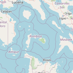
Map view of Marinduque Wildlife Sanctuary

Use this park location map to pinpoint Marinduque Wildlife Sanctuary in Philippines, understand its exact geographic position, and read its mapped placement within the surrounding landscape more clearly.

Pigeon | © OpenStreetMap contributors

Location context for Marinduque Wildlife Sanctuary

Marinduque
Park atlas

Compare adjacent forest reserves, island habitats, and regional protected landscapes

Explore Other Parks Near Marinduque Wildlife Sanctuary and Surrounding Protected Areas

Browsing other protected areas near Marinduque Wildlife Sanctuary helps connect isolated inland forest habitats with broader regional conservation trends. Comparing adjacent natural reserves provides a comprehensive geographic view of island ecosystems and wildlife corridors across the surrounding region.
Wildlife reserveQuezon
About 64 km away#1 closest

East

Mulanay Watershed Forest Reserve: Mapping Protected Lowland Rainforests in Quezon

A watershed conservation site on the Bondoc Peninsula

Spanning 474 hectares in the province of Quezon, the Mulanay Watershed Forest Reserve acts as a protected anchor for local biodiversity and hydrological health. The reserve preserves rolling, forest-covered hills that feed the Cawayan Creek, illustrating the importance of small, strategically managed protected lands within the larger Philippine conservation framework.

Area
4.74 km²
Established
1938
Relief
Upland
Water
Minor water
Protected landscapeQuezon
About 65 km away#2 closest

North

Quezon Protected Landscape: Mapping the Rainforests and Karst Terrain of Quezon Province

An essential protected landscape in the southern Sierra Madre mountain range.

Quezon Protected Landscape serves as a vital ecological corridor, featuring a rugged mix of karst topography, lowland rainforests, and underground water systems. Explore the geographic layout of this Philippine reserve, which encompasses symbolic summits, cascading waterfalls, and diverse endemic habitats within the southern Sierra Madre foothills.

Area
9.38 km²
Established
2003
IUCN
V
Relief
Mountain
Nature reserveQuezon
About 72 km away#3 closest

Northeast

Lopez Watershed Forest Reserve: Protected Nature Reserve and Watershed Atlas of Quezon

A foundational rainforest landscape within the Quezon province protected network.

Lopez Watershed Forest Reserve is a significant nature reserve located in the rolling hills of southern Quezon, Philippines. This site preserves a continuous block of tropical lowland and lower montane forest, functioning as an essential watershed catchment area within the broader Luzon landscape. Learn about its institutional importance and its role as an early component of the Philippine protected area management framework.

Area
4.18 km²
Established
1940
Relief
Upland
Water
Minor water
National parkPhilippines
About 72 km away#4 closest

West

Naujan Lake National Park: Philippines National Park Atlas and Protected Landscape

Explore its mapped boundaries and regional geographic context.

Naujan Lake National Park offers a focused exploration of a distinct protected landscape within the Philippines. This page details the park's specific geographic footprint and its characteristics as a national park. Understand its place within the archipelago's broader geography, providing a valuable entry point for atlas-based discovery of protected natural areas and their mapped extents across Southeast Asia.

Scope
Terrestrial
Water
Water-dominated
Wildlife reserveQuezon
About 73 km away#5 closest

Northeast

Calauag Watershed Reservation: Geographic Analysis of Protected Rainforest in Quezon Province

Mapping lowland tropical forest terrain and regional watershed boundaries

Located in the rolling hills of Quezon, the Calauag Watershed Reservation serves as a critical protected landscape featuring dense stands of Philippine hardwoods and varied forest microhabitats. This record details the reserve's topography, ranging from moderate slopes to drainage corridors, illustrating its function as both a biodiversity sanctuary and a essential water catchment for the surrounding CALABARZON region.

Area
3.28 km²
Established
1939
Relief
Upland
Climate
Tropical
Wildlife reserveQuezon
About 80 km away#6 closest

North

Alabat Watershed Forest Reserve: Wildlife Reserve and Regional Watershed Geography in Quezon

Exploring the protected lowland rainforests of Alabat Island.

Located in Quezon, the Alabat Watershed Forest Reserve represents a significant wildlife reserve defined by its ridge and valley topography. The landscape serves as a protected catchment for the Langas River, maintaining essential lowland forest cover amidst the island environment. This entity provides a clear look at the ecological significance and mapped boundaries of a vital Philippine watershed and forest system.

Area
6.88 km²
Established
1987
Relief
Upland
Scope
Terrestrial
A horizontal watercolor painting of a mangrove forest with green canopies and characteristic prop roots rising from calm, reflective mudflats against a white background.
Protected landscapeCalabarzon
About 84 km away#7 closest

East

Alibijaban Protected Landscape and Seascape: Coastal and Marine Geography

A protected island refuge in the Ragay Gulf of Calabarzon

The Alibijaban Protected Landscape and Seascape is a significant conservation site known for its undisturbed mangrove interior and thriving coral reef ecosystems. Its geography features flat terrain, sandy beaches, and complex seagrass meadows that attract diverse wildlife. This map-based overview provides detailed insights into the protected island's physical boundaries and unique marine-terrestrial intersection.

Area
10.56 km²
Established
1981
Relief
Lowland
Climate
Tropical
A watercolor painting showing a winding stream flowing through grassy wetlands toward distant low mountain ranges.
National parkPhilippines
About 89 km away#8 closest

West

Lake Naujan National Park: An Atlas of Volcanic Lakes and Wetland Geography

Mapped protected landscapes in the Philippines

Lake Naujan National Park occupies a unique geographic position on Mindoro Island, centering on a vast volcanic freshwater lake. The protected area integrates diverse terrain ranging from aquatic wetland zones and thermal springs to lowland forests and managed agricultural buffers, providing an essential study in human-modified conservation landscapes.

Common questions about visiting, size, designation, and location context for Marinduque Wildlife Sanctuary

Marinduque Wildlife Sanctuary FAQs for park facts, access, geography, and protected area context

Find quick answers about Marinduque Wildlife Sanctuary, including protected-area facts, park geography, trail and visitor context, and how the park fits into its surrounding country and regional landscape.
MoriAtlas Explorer

Continue Your Protected Areas Search Across the Global Atlas

Deepen your exploration by continuing the structured search for national parks and protected areas worldwide. Utilize the comprehensive filtering capabilities to compare different conservation landscapes and refine your understanding of global park geography. Discover more about the distribution and characteristics of protected natural areas.

Global natural geography