Mori Atlas logo
Wildlife reserveMazatzal Wilderness

Tracing the elevation gradient from the Verde River corridor to the Mazatzal Divide summits

Mazatzal Wilderness: A Comprehensive Geographic Atlas of Arizona Protected Mountain Landscapes

Mazatzal Wilderness represents a significant protected wilderness block in central Arizona, encompassing a varied terrain that stretches across the Tonto and Coconino National Forests. This landscape spans an extensive vertical transition, shifting from arid desert shrubland along the Verde River to dense ponderosa pine and Douglas-fir forests near Mazatzal Peak. Spanning roughly 390 square miles, this wilderness area serves as a primary example of rugged southwestern topography shaped by deep canyons and forested ridgelines.

wilderness areaArizona backcountryVerde River corridorMazatzal MountainsTonto National ForestCoconino National Forest

Mazatzal Wilderness

Wildlife reserve

Park overview

Structured park overview, official facts, and landscape profile for Mazatzal Wilderness

Mazatzal Wilderness park facts, protected area profile, and essential visitor context

Review the core facts for Mazatzal Wilderness, including designation, size, terrain, visitor scale, habitats, and operating context in one park-focused overview.

About Mazatzal Wilderness

Mazatzal Wilderness is one of the anchor wilderness areas of central Arizona, occupying more than 250,000 acres across the rugged interior between the Verde River and the Mogollon Rim country. Designated in 1964 and managed by the U.S. Forest Service, it overlaps the Tonto National Forest in its southern portion and the Coconino National Forest to the north, giving it a continuous character across two major national forest units. The nearest community of meaningful size is Payson, to the east, while the Verde River defines much of the western boundary and supplies one of the area's defining natural corridors.

The wilderness's identity is shaped by elevation contrast. Its lowest points lie near Sheep Bridge along the Verde River at roughly 2,100 feet, a hot, dry setting where desert-shrub vegetation dominates. From there, the land rises across foothills, canyons, and long ridgelines toward Mazatzal Peak at 7,903 feet, where cooler temperatures support Douglas-fir and dense stands of ponderosa pine. In between lies an unusually rich ecological gradient, including grassland openings, dense chaparral of manzanita and shrub live oak, and scattered pinyon-juniper woodland.

A network of about 240 miles of trails crosses the wilderness, supporting everything from short river-walk excursions along the Verde River Trail, which follows the river for roughly 28 miles, to longer backcountry traverses along the Mazatzal Divide Trail, which runs about 29 miles through the high country. Because the area is large, relatively remote, and climatically intense in summer, with daytime temperatures that can climb above 110 degrees Fahrenheit, it is better known for shoulder-season hiking, equestrian use, and extended backpacking than for casual day visits. Its combination of desert river, conifer-clad peaks, and long ridge trails makes it a defining piece of Arizona's preserved backcountry.

Quick facts and research context for Mazatzal Wilderness

Mazatzal Wilderness spans Yavapai and Gila counties in central Arizona, and is co-administered across the Tonto and Coconino national forests. It covers about 252,390 acres, or roughly 390 square miles, making it one of the larger wilderness areas in Arizona. The federal wilderness designation dates to 1964, and the area is managed by the U.S. Forest Service.

Elevations range widely, from approximately 2,100 feet where Sheep Bridge crosses the Verde River to 7,903 feet at Mazatzal Peak. The wilderness is anchored on its western side by the Verde River and framed on its eastern side by the town of Payson. About 240 miles of marked trails connect the area, including the Verde River Trail and the Mazatzal Divide Trail, two of the defining routes within the wilderness.

Protection and recognition

Examine documented conservation scope and international recognition facts for Mazatzal Wilderness.

Mazatzal Wilderness Protection Status and Territorial Designation Records

Territorial protection records for Mazatzal Wilderness outline the documented conservation scope and management parameters established for the protected landscape. Official recognition data details international designations and administrative status compiled across available registry sources.

Protection details

Protection scope
Terrestrial
Transboundary protection
No
Park context

Deeper park guide and search-rich context for Mazatzal Wilderness

Mazatzal Wilderness history, landscape, wildlife, and travel context

Explore Mazatzal Wilderness through its history, landscape character, ecosystems, wildlife, conservation priorities, cultural context, and seasonal travel timing in a structured park guide built for atlas discovery and search intent.

Why Mazatzal Wilderness stands out

Mazatzal Wilderness is best known for its dramatic ecological gradient within a single protected landscape. In a comparatively compact region, it moves from hot desert-shrub vegetation along the Verde River through pinyon-juniper woodlands and into cooler forests of ponderosa pine and Douglas-fir near Mazatzal Peak. This vertical zonation gives the wilderness a layered character that is unusual for Arizona's lower-elevation wilderness areas. The area is also recognized for the Mazatzal Divide Trail, a long-distance route tracing the spine of the mountains, and for the wild stretch of the Verde River that forms its western boundary. Together, the river corridor and the forested divide define the wilderness's two strongest scenic and recreational identities.

Mazatzal Wilderness history and protected-area timeline

The Mazatzal Wilderness was formally designated in 1964, placing its sizable tract of central Arizona backcountry under federal wilderness protection at a relatively early moment in the modern American wilderness movement. Its establishment occurred against the backdrop of debate over how to manage the rugged, often inhospitable lands surrounding the Verde River and the Mazatzal Mountains, lands that had been used for grazing, mining, and small-scale logging before being folded into the national forest system.

By drawing parts of both the Tonto National Forest and the Coconino National Forest into a single wilderness designation, the 1964 act recognized that the area's ecological and topographic character did not follow administrative boundaries. Subsequent decades have largely been a story of managed restraint. Trails have been maintained rather than expanded, motorized access has been tightly limited, and the wilderness has been allowed to function as a working example of arid Southwest backcountry under strict federal protection rather than as a heavily developed recreation site.

Mazatzal Wilderness landscape and geographic character

The landscape of Mazatzal Wilderness is defined by its dramatic elevation range and the contrast between its two flanking geographic features: the Verde River and the Mazatzal Divide. Along its western edge, the Verde River has cut a deeply incised corridor through rugged terrain, producing steep canyon walls, gravel bars, and a string of side drainages. Near Sheep Bridge, the river sits at roughly 2,100 feet, and the surrounding slopes are dry, sun-exposed, and dominated by desert-shrub vegetation.

Moving eastward and upward, the terrain transitions into the central highlands of the Mazatzal Mountains. Long, sometimes knife-edged ridgelines, including the spine followed by the Mazatzal Divide Trail, rise through successive vegetation belts. Mid-elevations are characterized by rolling hills and benches covered in manzanita, shrub live oak, and grassy openings, while the upper slopes and north-facing aspects support denser stands of ponderosa pine and, near the summits, Douglas-fir. Mazatzal Peak, the high point at 7,903 feet, anchors this forested summit zone and gives the entire wilderness its name.

Throughout the area, the topography is shaped by erosion. Canyons branch off from both the river and the divide, creating complex patterns of ridges, benches, and washes. The result is a landscape that reads as two contrasting worlds, desert canyon and forested mountain ridge, contained within a single contiguous wilderness block.

Mazatzal Wilderness ecosystems, habitats, and plant life

Ecologically, Mazatzal Wilderness functions as a transition zone where desert, woodland, and forest biomes overlap within a relatively short vertical span. Shrublands of creosote and other desert plants occupy the lowest elevations along the Verde River corridor, where conditions are hot and dry for much of the year. Moving upward, these desert communities give way to a broad belt of chaparral and woodland, with manzanita and shrub live oak forming dense, often impenetrable thickets on rocky slopes.

Above the chaparral, pinyon-juniper woodlands appear in scattered stands, marking the shift toward cooler, more mesic conditions. Higher still, the slopes and ridges carry open to moderately dense ponderosa pine forest, with Douglas-fir joining the mix on the coolest, highest sites near Mazatzal Peak. Grassland openings punctuate the woodland and forest zones, especially on broader benches and along ridgelines, contributing to the area's mosaic of habitats.

Because the wilderness spans such a wide elevation gradient and straddles the interface between Sonoran and Mogollon highland ecosystems, it supports a broader range of plant communities than its arid setting would at first suggest. This vertical stacking of vegetation types is one of the defining ecological features of the wilderness.

Mazatzal Wilderness wildlife and species highlights

Mazatzal Wilderness's combination of riverine habitat, desert slope, and forested high country gives it a correspondingly wide range of wildlife. The Verde River corridor along the western margin attracts riparian-dependent species and supports seasonal bird activity, while the chaparral and mid-elevation slopes provide cover for mule deer, javelina, and a variety of smaller mammals adapted to thick brush. Mountain lions are present in the more remote upper elevations, though they are rarely seen.

The forested zones around the Mazatzal Divide and Mazatzal Peak host bird communities typical of Arizona's mid-elevation pine forests, including woodpeckers, nuthatches, and a variety of songbirds associated with ponderosa pine and mixed conifer stands. Raptors such as hawks are regularly observed along the ridgelines, where updrafts and open airspace make productive hunting grounds.

Because the area is large and the human footprint relatively light, especially outside the trail corridors, Mazatzal Wilderness retains habitat diversity that supports wide-ranging animal movement. The wilderness is best understood not as a refuge for a single signature species but as a working landscape in which desert, chaparral, and forest wildlife communities all remain present across their respective elevation bands.

Mazatzal Wilderness conservation status and protection priorities

The conservation significance of Mazatzal Wilderness lies in its scale and in the ecological gradient it protects. At roughly 250,000 acres, it preserves a continuous block of central Arizona backcountry large enough to maintain ecological processes, wildlife movement, and watershed function at a regional scale. Its western boundary coincides with a long stretch of the Verde River, one of Arizona's most important rivers, and its protected status helps insulate that corridor from the kinds of development pressures seen in surrounding lowland areas.

Wildness designation brings with it strict limits on road-building, motorized use, and permanent infrastructure, which has allowed the wilderness's vegetation communities to remain largely intact since 1964. The combination of intact river corridor, continuous chaparral and woodland, and high-elevation forest makes the area valuable not only for the species it hosts but also for the broader watershed and airshed it anchors across central Arizona.

In conservation terms, Mazatzal Wilderness is best seen as a connective piece of the larger network of protected lands stretching across the Mogollon Rim and Tonto Basin regions. Its long-term value is tied as much to what it keeps undeveloped between neighboring protected areas as to any single species or feature within its borders.

Mazatzal Wilderness cultural meaning and human context

The name Mazatzal comes from the Mazatzal Mountains, a range whose name reflects the region's indigenous and frontier-era history. The mountains and surrounding country have long been part of the traditional homelands and movement corridors of Native peoples of central Arizona, and references to the Mazatzal appear in older geographic and ethnographic usage of the region.

In more recent history, the area sits within ranching and small-scale mining country that was gradually absorbed into the national forest system during the twentieth century. Payson, the nearest substantial town, developed as a regional center in this part of central Arizona and has long served as a gateway community for recreation in the surrounding forests and wilderness. The cultural identity of the Mazatzal region today is tied to this combination of rugged natural setting, traditional land use, and small-town recreation culture rather than to any single prominent heritage site within the wilderness.

Top sights and standout views in Mazatzal Wilderness

Mazatzal Wilderness stands out for the scale of its uninterrupted backcountry and for the way a single protected area links a wild stretch of the Verde River with the forested Mazatzal Divide. Within its borders, visitors can move on foot from near-desert riparian terrain at Sheep Bridge to the pine-clad slopes beneath Mazatzal Peak without ever leaving designated wilderness.

The Verde River Trail and the Mazatzal Divide Trail together form the spine of the wilderness experience, offering long-distance hiking and backpacking in a setting that combines arid canyon country with high-elevation forest. Together with the area's protected status under the 1964 wilderness designation, these two trail systems define much of what makes Mazatzal Wilderness distinctive among Arizona's preserved landscapes.

Best time to visit Mazatzal Wilderness

The cooler months of fall, winter, and spring are generally the most favorable window for experiencing Mazatzal Wilderness. During this period, daytime temperatures at lower elevations along the Verde River corridor are moderate, and the higher ridges, including the Mazatzal Divide, can be walked in conditions that are far more forgiving than the harsh summer heat that can push temperatures above 110 degrees Fahrenheit in the lowlands.

Spring brings active growth in the chaparral and grassland zones and increasing bird activity across all elevation bands, while fall often delivers cooler overnight temperatures and clearer skies in the high country. Summer visits are possible but require serious preparation for heat, limited water, and remote terrain, and are best suited to experienced backcountry users. Winter conditions near Mazatzal Peak can include snow and cold nights, so shoulder seasons remain the most accessible and rewarding times for most visitors.

Monthly climate preview

Long-term representative point measurements tracking annual temperature and precipitation rhythm

Mazatzal Wilderness Climate Normals, Average Temperatures and Monthly Precipitation

Representative coordinate records show average monthly temperatures ranging from 7.76 degrees Celsius in winter to 30.05 degrees Celsius in mid-summer alongside shifting precipitation rates. Examining the full twelve-month profile reveals complete climate normals across the protected landscape.
Annual mean19 °C
8 °C30 °C
Jan
Feb10°
Mar13°
Apr17°
May22°
Jun28°
Jul30°
Aug29°
Sep26°
Oct20°
Nov13°
Dec
Warmest month
July

30.1 °C

Coolest month
December

7.8 °C

Wettest month
February

1.7 mm/day

Driest month
June

0.1 mm/day

Park location guide

Geography guide, regional context, and park location map for Mazatzal Wilderness

Mazatzal Wilderness park geography, regions, and map view in United States of America

Understand where Mazatzal Wilderness sits in United States of America through a broader geographic reading of the surrounding landscape, nearby location context, and its mapped position within the national park landscape.

How Mazatzal Wilderness fits into United States of America

The United States of America is a federal presidential republic and one of the world's largest countries by area and population. It consists of 50 states across a vast territory spanning multiple time zones, with its capital in Washington, D.C. and largest city in New York City. The nation has a diverse economy, influential political system, and significant cultural and military presence globally.

Wider geography shaping Mazatzal Wilderness in United States of America

The United States occupies a vast territory in North America, bordered by Canada to the north and Mexico to the south. The 48 contiguous states stretch from the Atlantic to the Pacific Ocean, while Alaska occupies the northwestern region and Hawaii is an archipelago in the Pacific. The country encompasses diverse terrain including the Rocky Mountains, Appalachian Mountains, Great Plains, and extensive river systems.

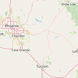
Map view of Mazatzal Wilderness

Use this park location map to pinpoint Mazatzal Wilderness in United States of America, understand its exact geographic position, and read its mapped placement within the surrounding landscape more clearly.

Pigeon | © OpenStreetMap contributors

Location context for Mazatzal Wilderness

Arizona
Recorded earthquake history

Examine the Recorded Earthquake History Associated with Mazatzal Wilderness

Access a structured, mapped collection of historical seismic records linked to the Mazatzal Wilderness region. This dataset allows for the examination of past magnitude and epicentre data without providing hazard predictions or risk assessments. Use these records to better understand the seismic history within this specific backcountry landscape.

Mazatzal Wilderness Earthquake History

Catalogued events

9 events

Strongest magnitude

Magnitude 4

Most recent event

Feb 19, 2025

This history includes earthquakes recorded inside the park or within 50 km of its borders

Park atlas

Compare adjacent wildlands, forest reserves, and regional protected landscapes

Exploring Other Parks and Protected Areas Near Mazatzal Wilderness

Browse neighboring protected areas and forest reserves that share the rugged topography of the surrounding region. Comparing adjacent wildlands provides deeper context for the arid canyons and high mountain terrain characteristic of the American Southwest.
Protected landscapeArizona
Park boundaries overlap#1 closest

Southeast

Tonto National Forest: Understanding the Geography of an Expansive Protected Landscape

Exploring the vertical ecosystem gradients in Central Arizona

Spanning from arid Sonoran basins to the towering Mogollon Rim, Tonto National Forest offers a unique study in vertical geography and protected land management. This expansive territory provides a vital map of Southwest life zones, encompassing reservoir systems, rugged river canyons, and critical wilderness habitat that define the environmental identity of the region.

Area
11,627 km²
Established
1905
Visitors
5.9M annual
Relief
Mountain
Watercolor painting of a calm lake surrounded by green forests and distant mountain ridges.
Protected areaArizona
5.6 km away#2 closest

Northwest

Prescott National Forest: Geographic Overview of Arizona Protected Landscapes and Wilderness

Regional geography and protected terrain map of the Bradshaw Mountains

Spanning over one million acres, Prescott National Forest represents a defining outdoor landscape in Arizona. The terrain transitions from high desert chaparral to dense ponderosa pine forests, featuring eight distinct wilderness areas, rugged canyon systems, and essential watershed corridors that shape the regional ecology near Prescott.

Area
5,100 km²
Established
1908
Relief
Mountain
Climate
Temperate
A horizontal watercolor illustration depicting a desert landscape with distant purple mountain peaks, rolling green hills, and a winding path, rendered in soft, light colors.
Wildlife reserveArizona
40 km away#3 closest

North

Munds Mountain Wilderness Protected Area and Red Rock Landscape Mapping

Arizona high-desert wilderness and canyon-edge geography

Located southeast of Sedona, Munds Mountain Wilderness encompasses roughly 18,150 acres of dramatic sandstone cliffs and elevated plateaus. This area serves as a key site for observing the convergence of pinyon-juniper woodlands with iconic desert rock formations, providing a clear window into the rugged topography of central Arizona.

Area
73.45 km²
Established
1984
IUCN
Ib
Relief
Mountain
A watercolor painting showing a winding river flowing through a forested valley with gentle hills in the background.
Wildlife reserveArizona
55 km away#4 closest

North

Red Rock-Secret Mountain Wilderness: A Geographic Overview of Arizona Protected Lands

Canyon landscapes and high mesa terrain in Arizona

Red Rock-Secret Mountain Wilderness serves as a significant protected block near Sedona, featuring a complex network of slot canyons, natural arches, and sandstone pinnacles. This wilderness area preserves the ecological transition from the high-elevation forested rim down into warmer, arid canyon bottoms, offering a deep look at the geology of the Colorado Plateau edge.

Area
191 km²
Established
1984
IUCN
Ib
Relief
Mountain
A horizontal watercolor illustration showing a calm lake in the foreground, surrounded by grassy banks, evergreen trees, and rolling mountains in the distance under a pale sky.
Protected landscapeArizona
75 km away#5 closest

North

Kaibab National Forest: Protected Plateau Landscapes and Forested Geography in Arizona

High-elevation forest terrain bordering the Grand Canyon

Spanning over 1.6 million acres in Arizona, Kaibab National Forest is characterized by its split geographic configuration, with distinct sections flanking the North and South rims of the Grand Canyon. The terrain ranges from the high-altitude Kaibab Plateau to volcanic uplands near Williams, encompassing four designated wilderness areas and varied forest ecosystems that provide a critical buffer for the surrounding canyon country.

Area
6,500 km²
Established
1909
Relief
Mountain
Climate
Temperate
A horizontal watercolor illustration showing rolling green hills and a treeline against a pale sky.
Wildlife reserveArizona
99 km away#6 closest

North

Kachina Peaks Wilderness; Geography and Protected Landscape Atlas of Arizona

High-altitude volcanic terrain and alpine ecosystems

Kachina Peaks Wilderness is a protected area in northern Arizona centered on the San Francisco Peaks. This geography includes the state's highest elevation at Humphreys Peak and a rare volcanic caldera known as the Inner Basin. The terrain transitions from dense mountain forests into an Arctic-Alpine zone, offering a distinct landscape for analyzing mountain evolution and high-elevation ecological patterns.

Area
75 km²
Established
1984
IUCN
Ib
Relief
Mountain
Wildlife reserveArizona
About 117 km away#7 closest

Southeast

Needle's Eye Wilderness: Protected Desert Geography and Mescal Mountain Topography

Gila River canyons and limestone desert landscapes in Arizona

Needle's Eye Wilderness encompasses a rugged segment of the Mescal Mountains where the Gila River has incised deep limestone gorges. This protected area features a striking shift between harsh arid uplands and a dense riparian corridor, offering a study in concentrated desert canyon topography and dramatic geological formations within southern Arizona.

Area
35.5 km²
Established
1990
IUCN
Ib
Relief
Mountain
Watercolor painting of a desert scene with rolling hills in the background and saguaro cacti in the foreground.
Wildlife reserveMaricopa County
128 km away#8 closest

West

Hummingbird Springs Wilderness: A Protected Sonoran Desert Landscape in Maricopa County

Rugged mountain terrain and desert wash networks

Spanning more than 31,000 acres, Hummingbird Springs Wilderness serves as a core protected area in the Sonoran Desert. The geography encompasses the Belmont Mountains, providing a stark contrast of arid peaks and sandy basins that extend through western Maricopa County. This roadless wilderness represents an essential connection between adjacent protected lands, maintaining a vast and isolated desert environment shaped by centuries of geological forces.

Area
126.26 km²
Established
1990
IUCN
Ib
Relief
Mountain

Common questions about visiting, size, designation, and location context for Mazatzal Wilderness

Mazatzal Wilderness FAQs for park facts, access, geography, and protected area context

Find quick answers about Mazatzal Wilderness, including protected-area facts, park geography, trail and visitor context, and how the park fits into its surrounding country and regional landscape.
MoriAtlas Explorer

Continue Your Protected Areas Search Across the Global Atlas

Deepen your exploration by continuing the structured search for national parks and protected areas worldwide. Utilize the comprehensive filtering capabilities to compare different conservation landscapes and refine your understanding of global park geography. Discover more about the distribution and characteristics of protected natural areas.

Global natural geography