

Mori Atlas logo
National parkMcAdam National Park

Explore the rugged montane terrain and dense forest boundaries of this central highland conservation area.

McAdam National Park in Morobe Province; Mapping the Protected Highland Rainforests of Papua New Guinea

McAdam National Park occupies a significant section of the mountainous Bulolo region within Morobe Province, Papua New Guinea. This protected area preserves a complex landscape of steep ridges, narrow valleys, and montane rainforests sitting at elevations exceeding 1,200 meters. The park serves as a vital anchor for highland forest conservation, showcasing the dramatic vertical terrain and dense canopy cover characteristic of the interior cordillera. Users can trace the park boundaries and examine the surrounding highland topography through this structured geographic atlas.

national parkPapua New GuineaMorobe Provincehighland forestmontane rainforesttropical forest

McAdam National Park

National park

Park overview

Structured park overview, official facts, and landscape profile for McAdam National Park

McAdam National Park park facts, protected area profile, and essential visitor context

Review the core facts for McAdam National Park, including designation, size, terrain, visitor scale, habitats, and operating context in one park-focused overview.

About McAdam National Park

McAdam National Park is one of Papua New Guinea's designated protected areas, situated in the eastern interior of the country within Morobe Province. Morobe is one of Papua New Guinea's largest and most ecologically diverse provinces, stretching from coastal lowlands along the Solomon Sea to highland ranges inland. Bulolo, the district in which the park lies, lies within this interior highland transition zone and has long been associated with gold mining and forest landscapes. The park's position within this region means it sits amid a mosaic of primary forest, regenerating vegetation, and mountainous terrain.

At roughly 1,250 meters of elevation, the park lies in a zone that is neither strictly lowland tropical nor truly alpine, but rather a middle-elevation montane environment. The surrounding landscape features forested ridges, steep slopes, and deep drainage corridors, with neighboring peaks rising to nearly 1,600 meters. The terrain is shaped by the tectonic and erosional forces that have molded Papua New Guinea's central cordillera, producing a landscape of continuous ridges and narrow valleys. This rugged topography creates a variety of microhabitats across relatively short distances, a pattern characteristic of Papua New Guinea's highland regions.

The area's tropical highland climate is marked by consistently cool temperatures relative to the lowlands, with mean readings around 13 degrees Celsius and seasonal variation limited to a few degrees. Rainfall is heavy and distributed throughout the year, with annual totals exceeding 2,800 millimeters and a wettest period during the middle of the calendar year. These conditions sustain dense, evergreen forest cover and contribute to the persistent humidity observed across the broader region. The park's protected status helps ensure that this highland forest environment remains intact in a region where land use pressures from forestry, mining, and subsistence activity are common.

Population density around the park is low, with only a handful of inhabitants per square kilometer and the nearest larger settlement, Bulolo, just a few kilometers away. The presence of protected forest here is significant given the importance of Papua New Guinea's forests for watershed function, biodiversity, and the integrity of major river systems draining both northward and southward from the central ranges.

Quick facts and research context for McAdam National Park

McAdam National Park is situated in the Bulolo District of Morobe Province, Papua New Guinea, roughly 250 kilometers north of Port Moresby. The park is positioned at an elevation of over 1,200 meters, with neighboring terrain rising to around 1,500 meters or higher. The area experiences a tropical highland climate with mean annual temperatures in the low teens Celsius and heavy rainfall throughout the year, exceeding 2,500 millimeters annually. The closest notable town is Bulolo, which lies a few kilometers to the north.

Protection and recognition

Documented terrestrial protection scope and international recognition records

McAdam National Park Protection Status and Conservation Recognition

McAdam National Park holds a recorded terrestrial protection scope within the global conservation database. Documented protection status details, management parameters, and international recognition records provide transparent context for the protected area.

Protection details

Protection scope
Terrestrial
Park context

Deeper park guide and search-rich context for McAdam National Park

McAdam National Park history, landscape, wildlife, and travel context

Explore McAdam National Park through its history, landscape character, ecosystems, wildlife, conservation priorities, cultural context, and seasonal travel timing in a structured park guide built for atlas discovery and search intent.

Why McAdam National Park stands out

McAdam National Park is notable for protecting a tract of highland forest within the Morobe Province of Papua New Guinea. The park's defining character comes from its location within the rugged, forested terrain of the Bulolo region, where steep ridges, deep valleys, and montane rainforest define the landscape. Its position at over 1,000 meters of elevation places it firmly within Papua New Guinea's tropical highland ecological zone, a setting that supports distinctive forest vegetation and montane environmental conditions.

McAdam National Park landscape and geographic character

McAdam National Park occupies a rugged section of the Morobe highland landscape, where mountainous terrain dominates the surrounding region. The park's elevation of around 1,250 meters places it within a transitional montane setting, and a nearby peak rises to approximately 1,589 meters within roughly a kilometer of the park's central point. The broader topography is defined by forested ridges interspersed with steep slopes and narrow valley systems.

The slopes around the park face varied aspects, with terrain to the south and east tending to be dominated by higher ranges while northern flanks often extend into lower broken country. Forested cover blankets most of the surrounding terrain, with rainforest clinging to even the steeper inclines. This landscape pattern reflects the typical structure of Papua New Guinea's central ranges, where orographic rainfall, persistent humidity, and stable bedrock conditions together sustain continuous forest cover across large vertical spans.

Drainage lines fan outward from the surrounding ridges, contributing to the larger watershed systems of the Morobe interior. The combination of elevation, slope, and dense vegetation gives the park's setting a pronounced vertical character, with views from higher points typically extending across a sea of forest-covered ridges. The Bulolo region itself sits within a landscape long shaped by both natural processes and human activity such as alluvial gold mining, and McAdam National Park preserves a section of this terrain in its forested state.

McAdam National Park ecosystems, habitats, and plant life

The park protects an area of tropical highland forest within Papua New Guinea's Morobe Province. The regional vegetation pattern is one of continuous closed-canopy forest, with rainforest dominating slopes at mid-elevations and giving way to varied montane communities on higher terrain. The cool, wet climate fosters dense vegetative cover, and the slopes around the park maintain forest cover even where the topography is steepest.

Because the surrounding region has low population density and limited agricultural development, much of the forest around the park remains in a relatively intact condition. The park thus forms part of a broader network of highland forest habitat within Morobe, supporting the ecological continuity of forest cover across the central ranges of Papua New Guinea. Such montane environments are biologically significant in the broader context of New Guinea's biodiversity, which is among the richest on Earth for many plant groups.

The combination of elevation, persistent cloud cover considerations, and heavy rainfall produces conditions favorable for mossy, moisture-dependent vegetation communities typical of New Guinea's middle-elevation forests. These forests in turn support a wide range of associated ecological processes that depend on stable, undisturbed canopy conditions.

McAdam National Park wildlife and species highlights

The highland forests of Morobe Province, including the area around McAdam National Park, support diverse fauna typical of New Guinea's montane environments. Such habitats are known to host a wide variety of bird species, including many endemic to the island of New Guinea. Mammals common to New Guinea's forested interior, including various marsupials and rodents, also occur throughout these landscapes.

Because the source material for this park is limited in species-specific detail, the wildlife description is best kept at the level of ecological context rather than specific species listings. The protected status of the area contributes to maintaining habitat continuity for forest-dependent species across the broader Morobe highland region.

McAdam National Park conservation status and protection priorities

McAdam National Park forms part of Papua New Guinea's national protected-area framework, contributing to the preservation of highland forest in a province where land use pressures from forestry, mining, and subsistence agriculture are significant. By safeguarding a tract of montane forest at over 1,000 meters of elevation, the park helps maintain habitat continuity across the central ranges of the country.

New Guinea's forests are recognized globally for their exceptional biodiversity and endemism, and protected areas like McAdam contribute to preserving the ecological processes that sustain this richness. In the broader Morobe context, the park complements the province's network of conservation areas that together maintain forest cover across a wide range of elevations and habitat types.

Top sights and standout views in McAdam National Park

McAdam National Park protects a section of highland rainforest in one of Papua New Guinea's most ecologically diverse provinces, Morobe. Its setting at over 1,200 meters places it firmly within the country's montane forest zone, and its location near the small town of Bulolo reflects the broader pattern of forested valleys that define the region. The park's protected status preserves a tract of rugged, forested terrain in a landscape long associated with both natural richness and human land use. Together, these qualities give the park its identity as a highland forest protected area within the Morobe interior.

Best time to visit McAdam National Park

The Morobe highland region around McAdam National Park experiences relatively stable temperatures year-round, with averages in the low teens Celsius and only modest seasonal variation. Rainfall is distributed throughout the year, though the middle months of the calendar year tend to be wetter, while early-year months receive somewhat less precipitation. Visitors favoring somewhat drier conditions may find early-year periods more accessible, though the park's highland forest atmosphere and ecological character remain consistent across seasons.

Monthly climate preview

Long-term representative point measurements for Morobe Province monthly weather patterns

McAdam National Park Climate Normals, Annual Temperature and Precipitation Rhythm

Representative coordinate records show average temperatures ranging from 19.5 degrees Celsius to 21.3 degrees Celsius alongside monthly precipitation varying from 1.54 to 7.35 millimeters per day. Examining the complete twelve-month profile provides detailed meteorological statistics and comprehensive seasonal averages for research comparison.
Annual mean20 °C
20 °C21 °C
Jan21°
Feb21°
Mar21°
Apr21°
May20°
Jun20°
Jul20°
Aug20°
Sep20°
Oct21°
Nov21°
Dec21°
Warmest month
December

21.3 °C

Coolest month
July

19.5 °C

Wettest month
March

7.4 mm/day

Driest month
July

1.5 mm/day

Park location guide

Geography guide, regional context, and park location map for McAdam National Park

McAdam National Park park geography, regions, and map view in Papua New Guinea

Understand where McAdam National Park sits in Papua New Guinea through a broader geographic reading of the surrounding landscape, nearby location context, and its mapped position within the national park landscape.

How McAdam National Park fits into Papua New Guinea

Papua New Guinea is an island nation in the southwestern Pacific Ocean, comprising the eastern half of the island of New Guinea and hundreds of offshore islands. It gained independence from Australia in 1975 and operates as a constitutional monarchy within the Commonwealth. The country is renowned for having the world's highest linguistic diversity, with over 840 known languages.

Wider geography shaping McAdam National Park in Papua New Guinea

Papua New Guinea occupies the eastern half of the island of New Guinea and hundreds of smaller islands in Melanesia. It shares a land border with Indonesia to the west and has maritime boundaries with Australia to the south and the Solomon Islands to the east. The terrain is predominantly mountainous, with the land supporting extraordinary biodiversity.

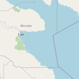
Map view of McAdam National Park

Use this park location map to pinpoint McAdam National Park in Papua New Guinea, understand its exact geographic position, and read its mapped placement within the surrounding landscape more clearly.

Pigeon | © OpenStreetMap contributors

Location context for McAdam National Park

Morobe Province
Park atlas

Compare regional montane rainforests and connected conservation areas across the interior highlands

Exploring Parks Near McAdam National Park and Surrounding Protected Landscapes

Browse other protected areas and rugged mountain terrain located near McAdam National Park. Comparing adjacent highland forest reserves provides deeper geographic context for the broader Morobe provincial ecosystem.
Wildlife reserveMorobe Province
About 153 km away#1 closest

North

YUS Conservation Area: Mapping the Geographic Range of a Community-Led Wildlife Reserve

Protected tropical forest landscapes in Morobe Province, Papua New Guinea

YUS Conservation Area represents a significant shift in regional conservation, protecting a massive altitudinal gradient on the Huon Peninsula. From coastal coral reef environments to the rugged ridges of the Saruwaged Mountains, the area preserves critical montane habitats and riverine corridors. This dataset provides insight into its unique geography, spanning lowland forests to highland peaks while showcasing a model of land management driven by customary community agreements.

Area
760 km²
Established
2009
Relief
Mountain
Climate
Tropical
Wildlife reserveChimbu Province
About 190 km away#2 closest

West

Crater Mountain Wildlife Management Area: Geography and Protected Land Boundaries in Chimbu Province

Central highland rainforest and cordillera wilderness terrain.

Crater Mountain Wildlife Management Area encompasses a massive tract of undisturbed highland rainforest across the central cordillera of Papua New Guinea. This protected zone demonstrates a unique intersection of tropical montane biodiversity and community-led conservation, providing an essential refuge defined by steep topography, persistent moisture, and continuous forest cover that stretches across the Chimbu Province.

Relief
Highland
Water
Major water bodies
Stylized illustration of a mountain with waterfalls, river, and trees under a bright sky with clouds
Protected areaPapua New Guinea
About 240 km away#3 closest

Northwest

Mount Wilhelm Protected Area: Papua New Guinea's Highest Peak and Alpine Terrain

Mapped geography and protected landscape context for a key Oceania peak.

Mount Wilhelm represents a significant protected area and the highest mountain in Papua New Guinea. Situated within the Bismarck Range, its dramatic granite peak defines a unique alpine environment, transitioning from dense rainforests to high-altitude grasslands. The presence of twin glacial lakes, Piunde and Aunde, adds to its distinctiveness, offering insight into the region's varied natural terrain and its role as a key geographical landmark.

Relief
Mountain
Climate
Alpine
Access
Moderate access
Scope
Terrestrial
National parkCentral Province
About 253 km away#4 closest

South

Varirata National Park: Protected Rainforest and Highland Terrain Atlas

Mapped geography of Central Province rainforest reserves

Varirata National Park is a significant protected area within the Central Province of Papua New Guinea, known for its elevated tropical rainforest ridges and varied topography. This map-based entry provides context on its landscape character, environmental setting, and role as an essential forest refuge in the highlands near the national capital.

Relief
Highland
Water
Minor water
Nature reserveWestern Highlands Province
About 335 km away#5 closest

Northwest

Baiyer River Sanctuary: Protected Highland Rainforest and River Valley Geography

Nature reserve in the Western Highlands Province of Papua New Guinea.

Located within the Western Highlands, Baiyer River Sanctuary protects 740 hectares of dense oak-dominated rainforest. This nature reserve provides essential habitat for birds-of-paradise, maintaining a continuous canopy across high-rainfall mountain slopes that bridges the transition between lowland and alpine ecosystems.

Area
7.4 km²
Established
1968
Relief
Upland
Climate
Tropical
Wildlife reserveSouthern Highlands Province
About 377 km away#6 closest

West

Lake Kutubu Wildlife Reserve: Geographic Boundaries and Highland Ecosystem Mapping

Protected freshwater terrain in the Southern Highlands Province

Lake Kutubu represents an essential protected landscape in the Papua New Guinea highlands, serving as a critical upland basin for diverse freshwater species. This overview highlights the reserve's unique geographic setting, covering its expansive 19-kilometer stretch, surrounding montane forests, and its role within the Kikori River catchment. Access detailed landscape context and regional environmental data for this globally significant lacustrine ecosystem.

Area
51.84 km²
Relief
Mountain
Scope
Terrestrial
Water
Water-dominated
A wide watercolor illustration showing green hills in the distance, a body of shallow water with pink and green patches, and foreground vegetation including green grasses and pink coral-like structures.
Marine protected areaQueensland
About 418 km away#7 closest

South

Great Barrier Reef Marine Park: Atlas and Geographic Context for Queensland Protected Waters

Exploring the reef system and marine conservation zones in northeastern Australia

The Great Barrier Reef Marine Park stands as an internationally significant marine protected area. By spanning a massive stretch of the Queensland coast, this protected landscape provides a critical framework for marine governance and reef conservation. Users can examine the unique zoning and distribution of coral reef habitats that define this extensive tropical ecosystem.

Area
343,966 km²
Established
1975
Climate
Tropical
Scope
Marine
National parkAustralia
About 581 km away#8 closest

Southwest

Yamarrinh Wachangan Islands (Denham Group) National Park: Australian Protected Landscape Map and Geography

Mapped boundaries and regional geographic context within Australia.

This detail entry for Yamarrinh Wachangan Islands (Denham Group) National Park provides specific geographic context and atlas information for this Australian national park. It focuses on the protected landscape identity, mapped features, and regional setting, offering a factual foundation for understanding the park's place within Australia's protected areas network. Explore its unique geographic characteristics and its designation as a national park.

Common questions about visiting, size, designation, and location context for McAdam National Park

McAdam National Park FAQs for park facts, access, geography, and protected area context

Find quick answers about McAdam National Park, including protected-area facts, park geography, trail and visitor context, and how the park fits into its surrounding country and regional landscape.
MoriAtlas Explorer

Continue Your Protected Areas Search Across the Global Atlas

Deepen your exploration by continuing the structured search for national parks and protected areas worldwide. Utilize the comprehensive filtering capabilities to compare different conservation landscapes and refine your understanding of global park geography. Discover more about the distribution and characteristics of protected natural areas.

Global natural geography

