Mori Atlas logo
Wildlife reserveMcCormick Wilderness

Exploring the roadless forest terrain and primary river headwaters of the western Upper Peninsula

McCormick Wilderness: A Protected Northern Forest Landscape in Michigan's Upper Peninsula

McCormick Wilderness represents a vital 17,000-acre protected landscape within Michigan's Ottawa National Forest. This roadless area preserves a recovering mosaic of northern hardwood and conifer forests, while acting as the crucial source for the Huron, Dead, Peshekee, and Yellow Dog Rivers. The terrain serves as an essential case study in ecological restoration following early twentieth-century logging activities.

wilderness areanational forestOttawa National ForestUpper PeninsulaMichiganriver headwaters

McCormick Wilderness

Wildlife reserve

Park overview

Structured park overview, official facts, and landscape profile for McCormick Wilderness

McCormick Wilderness park facts, protected area profile, and essential visitor context

Review the core facts for McCormick Wilderness, including designation, size, terrain, visitor scale, habitats, and operating context in one park-focused overview.

About McCormick Wilderness

McCormick Wilderness occupies a quiet corner of the western Upper Peninsula of Michigan, straddling the boundary between Baraga County and Marquette County and lying just east of the Baraga-Marquette county line. The nearest town of any size is L'Anse, but the Wilderness itself feels far removed from any settlement. Its 17,000 acres are administered by the U.S. Forest Service as part of the Ottawa National Forest, a vast forest reserve that also contains the older Sturgeon River Gorge Wilderness and the ecologically unusual Sylvania Wilderness.

The defining feature of McCormick Wilderness is its hydrology. Within its relatively compact footprint, the area holds headwater sections of four significant rivers: the Huron, the Dead, the Peshekee, and the Yellow Dog. Each of these rivers flows outward from the Wilderness into different parts of the Upper Peninsula, draining eventually toward Lake Superior. This concentration of headwaters gives the Wilderness a particular importance for downstream water quality, riparian habitat, and aquatic connectivity in the region.

Forest character is equally central to the area's identity. Although the landscape was logged extensively through the late nineteenth and early twentieth centuries, the cutover lands have gradually returned to forest. Today the Wilderness supports mixed stands of conifers, including spruce and fir, alongside northern hardwoods such as sugar maple, yellow birch, and birch species typical of the northern Great Lakes forest. The regrown forest hosts reintroduced moose, which have become an increasingly visible symbol of the area's wildlife character.

The human story behind McCormick Wilderness is distinctive within the National Wilderness Preservation System. The tract was assembled piece by piece between 1904 and 1920 by the McCormick family of Chicago, the family associated with the McCormick harvesting machinery business. Decades later, the family willed the property to the federal government in 1967. After an interim period under federal management, Congress formally designated the area as Wilderness in 1987, cementing its protection as a place where ecological values and a roadless, undeveloped character would be preserved over the long term.

Quick facts and research context for McCormick Wilderness

McCormick Wilderness is a 17,000-acre congressionally designated Wilderness Area in the Upper Peninsula of Michigan, located in Baraga and Marquette Counties east of the county line. It is one of three Wilderness Areas within the Ottawa National Forest, the other two being Sturgeon River Gorge Wilderness and Sylvania Wilderness. The Wilderness protects headwater sections of four named rivers: the Huron, Dead, Peshekee, and Yellow Dog. It was formally designated in 1987 and is administered by the U.S. Forest Service as part of the National Wilderness Preservation System.

Protection and recognition

Documented terrestrial conservation framework and administrative scope

McCormick Wilderness Protection Status and International Recognition

McCormick Wilderness maintains a defined terrestrial protection scope within its designated conservation framework. Official records compile available administrative parameters, management boundaries, and baseline recognition data.

Protection details

Protection scope
Terrestrial
Transboundary protection
No
Park context

Deeper park guide and search-rich context for McCormick Wilderness

McCormick Wilderness history, landscape, wildlife, and travel context

Explore McCormick Wilderness through its history, landscape character, ecosystems, wildlife, conservation priorities, cultural context, and seasonal travel timing in a structured park guide built for atlas discovery and search intent.

Why McCormick Wilderness stands out

McCormick Wilderness is best known for the unusual density of major river headwaters packed into a relatively compact forest tract. The small Wilderness contains the source waters of four distinct rivers that flow in different directions across the western Upper Peninsula, giving the area outsized importance for downstream water quality and aquatic habitat. Beyond its hydrology, the Wilderness is valued as a recovering northern forest landscape. After decades of early-twentieth-century logging, the area has regrown into a mix of conifers and northern hardwoods, providing habitat for reintroduced moose and other species associated with the northern Great Lakes forest. Its quiet, roadless character and its lineage as private family land donated to the federal government further shape its identity as one of the more distinctive Wilderness Areas in the Michigan Upper Peninsula.

McCormick Wilderness history and protected-area timeline

The land that would become McCormick Wilderness was assembled gradually in the opening decades of the twentieth century. Members of the McCormick family of Chicago acquired the tract in a series of separate purchases between 1904 and 1920, building up a contiguous block of forest land in what is now the western Upper Peninsula of Michigan. At the time of acquisition, the area, like much of the surrounding region, was still shaped by the legacy of late-nineteenth and early-twentieth-century logging that had swept across the Upper Peninsula.

The family's connection to the land ended in 1967, when the property was bequeathed to the federal government. Federal ownership laid the groundwork for formal protection, but it took two more decades before the area received its current status. In 1987, Congress designated the McCormick tract as a Wilderness Area under the National Wilderness Preservation System, placing it under the long-term protection of the U.S. Forest Service. Today it is managed alongside the Sturgeon River Gorge Wilderness and the Sylvania Wilderness as one of three Wilderness Areas within the Ottawa National Forest.

McCormick Wilderness landscape and geographic character

The terrain of McCormick Wilderness is characteristic of the western Upper Peninsula: gently rolling, densely forested, and dotted with small streams, bogs, and river headwaters rather than dramatic mountains or cliffs. Elevations are modest, but the relief is enough to shape slow-moving waterways that eventually become the Huron, Dead, Peshekee, and Yellow Dog Rivers. The landscape breathes through its water network as much as through its topography.

Forest cover shapes almost every view within the area. Conifers and northern hardwoods form a continuous canopy across much of the Wilderness, broken occasionally by lowland wet ground, beaver-influenced wetlands, and small openings near waterways. In places, the regrown forest has begun to take on the look of mature northern woodland, even where the underlying soil still reflects the area's logging past.

McCormick Wilderness ecosystems, habitats, and plant life

Ecologically, McCormick Wilderness belongs firmly to the northern Great Lakes forest region. Its mix of conifers and northern hardwoods reflects a forest community that, even after decades of regrowth, retains the species composition typical of the Upper Peninsula's most intact inland landscapes. Spruce, fir, and other conifers share the canopy with sugar maple, yellow birch, and other hardwoods, creating a structurally diverse forest.

The Wilderness's network of headwater streams and rivers gives it particular ecological significance. These small, cold-water streams support aquatic communities that depend on the unroaded, undeveloped character of the surrounding forest for their continued health. Wetlands and poorly drained lowlands add to the habitat mosaic, supporting amphibians, beaver activity, and quiet wet zones that punctuate the otherwise continuous forest.

McCormick Wilderness wildlife and species highlights

Wildlife in McCormick Wilderness reflects the broader character of the Upper Peninsula's northern forests. The area is associated with the recovery and presence of moose, reintroduced to the region and now roaming widely across suitable habitat. Their presence has become one of the more recognizable wildlife features of the Wilderness and of the Ottawa National Forest more broadly.

Beyond moose, the area supports the typical suite of species associated with mixed northern hardwood-conifer forest and associated wetlands, including white-tailed deer, black bear, smaller carnivores, and a range of birds tied to northern forest and riparian habitat. The Wilderness's protected status and roadless condition help maintain the quiet, low-disturbance setting that many of these species require.

McCormick Wilderness conservation status and protection priorities

McCormick Wilderness matters from a conservation perspective for several reinforcing reasons. Its formal Wilderness designation places it under the highest level of land protection available within the U.S. Forest Service system, restricting road-building, mechanized use, and resource extraction. That legal shield, combined with its position inside the Ottawa National Forest, helps guarantee that the area's second-growth forest will continue to mature rather than be returned to active timber harvest.

The area's hydrology adds a second conservation dimension. Because the Wilderness contains headwaters of four separate rivers, its condition directly influences water quality, stream temperature, and aquatic habitat downstream. In a region where logging history and watershed health have long been intertwined, the undisturbed forested buffer these headwaters receive is a meaningful ecological asset.

The Wilderness also plays a part in a larger landscape-scale conservation context. Together with the Sturgeon River Gorge Wilderness and the Sylvania Wilderness, it forms a network of formally protected areas within the Ottawa National Forest that preserves different expressions of Upper Peninsula forest and water systems.

McCormick Wilderness cultural meaning and human context

The cultural identity of McCormick Wilderness is closely tied to the McCormick family, whose name remains on the landscape long after their ownership ended. The family, associated with McCormick reaper and harvesting machinery, assembled the tract in the early twentieth century and ultimately bequeathed it to the federal government. That lineage sets the Wilderness apart from protected areas that emerged primarily from federal acquisition or state-led conservation efforts.

The surrounding Upper Peninsula also carries a deep heritage tied to forest industry, small rural communities, and the long aftermath of the great nineteenth-century logging era. The Wilderness stands today as one expression of how that heavily logged landscape has been reshaped, partly back into forest, partly into protected land, across the twentieth and twenty-first centuries.

Top sights and standout views in McCormick Wilderness

Within its 17,000 acres, McCormick Wilderness concentrates an unusual number of meaningful features: four distinct river headwaters, a regrown northern forest, reintroduced moose, and a quiet Wilderness character preserved under the strongest level of U.S. Forest Service protection. Its origins as a family-held tract donated to the federal government, before becoming part of the National Wilderness Preservation System in 1987, add a distinctive biographical note to its ecological identity. As one of three Wilderness Areas in the Ottawa National Forest, it complements the Sturgeon River Gorge and Sylvania Wildernesses rather than competing with them, forming part of a regional network of protected northern forest landscapes.

Best time to visit McCormick Wilderness

Like much of the western Upper Peninsula, McCormick Wilderness is shaped by a strongly seasonal climate. Late spring through early fall generally offers the most accessible conditions for travel into the area, when forest roads and trails are dry enough to use and streams run at moderate levels. Summer brings long daylight hours and active wildlife, including the chance to observe species associated with the recovering forest.

Fall is often considered especially rewarding in the region, when the northern hardwood component of the forest turns color and the Wilderness takes on a vivid seasonal character. Winter brings heavy snow, deep cold, and far more demanding conditions; access narrows and the area is best left to experienced winter travelers. In every season, the Wilderness's remote and undeveloped character is its defining trait, and visitors should expect to travel lightly and self-sufficiently.

Monthly climate preview

Track monthly average temperatures and precipitation records across the representative coordinate profile

McCormick Wilderness Climate Normals, Long Term Temperature and Precipitation Patterns

McCormick Wilderness maintains a documented annual temperature and precipitation rhythm across sampled coordinates from 1991 to 2020. Reviewing the complete twelve month climate profile reveals long term thermal shifts and moisture averages for the protected landscape.
Annual mean5 °C
-10 °C18 °C
Jan-10°
Feb-9°
Mar-4°
Apr
May10°
Jun15°
Jul18°
Aug18°
Sep14°
Oct
Nov-1°
Dec-7°
Warmest month
July

18.3 °C

Coolest month
January

-10.1 °C

Wettest month
June

3.3 mm/day

Driest month
February

1.3 mm/day

Park location guide

Geography guide, regional context, and park location map for McCormick Wilderness

McCormick Wilderness park geography, regions, and map view in United States of America

Understand where McCormick Wilderness sits in United States of America through a broader geographic reading of the surrounding landscape, nearby location context, and its mapped position within the national park landscape.

How McCormick Wilderness fits into United States of America

The United States of America is a federal presidential republic and one of the world's largest countries by area and population. It consists of 50 states across a vast territory spanning multiple time zones, with its capital in Washington, D.C. and largest city in New York City. The nation has a diverse economy, influential political system, and significant cultural and military presence globally.

Wider geography shaping McCormick Wilderness in United States of America

The United States occupies a vast territory in North America, bordered by Canada to the north and Mexico to the south. The 48 contiguous states stretch from the Atlantic to the Pacific Ocean, while Alaska occupies the northwestern region and Hawaii is an archipelago in the Pacific. The country encompasses diverse terrain including the Rocky Mountains, Appalachian Mountains, Great Plains, and extensive river systems.

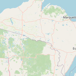
Map view of McCormick Wilderness

Use this park location map to pinpoint McCormick Wilderness in United States of America, understand its exact geographic position, and read its mapped placement within the surrounding landscape more clearly.

Pigeon | © OpenStreetMap contributors

Location context for McCormick Wilderness

Michigan
Park atlas

Compare adjacent forest landscapes and regional wilderness tracts across the Upper Peninsula.

Parks Near McCormick Wilderness and Surrounding Protected Areas

Browse other parks near McCormick Wilderness to examine connected northern forest reserves and protected river headwaters throughout the region. Continuing across neighboring wilderness areas provides broader geographic context for the protected landscapes of the Upper Peninsula.
A watercolor painting of a rolling, soft-toned landscape with a foreground of green forest and layers of hills receding into the distance.
Protected landscapeUpper Peninsula of Michigan
65 km away#1 closest

Southeast

Hiawatha National Forest: Geographic Overview and Protected Area Map of the Upper Peninsula

Coastal forest landscape and wilderness river corridors.

Hiawatha National Forest spans significant portions of the Upper Peninsula of Michigan, bridging the gap between northern hardwood forests and the boreal environments of the Great Lakes. This protected landscape encompasses extensive shorelines along Lake Superior, Lake Michigan, and Lake Huron, alongside six wilderness areas and five designated wild and scenic rivers.

Area
3,621.27 km²
Established
1931
IUCN
VI
Relief
Lowland
Wildlife reserveAlger County
78 km away#2 closest

East

Rock River Canyon Wilderness: Geographic Atlas and Protected Landscape Overview

Sandstone canyons and unmanaged forest terrain in Alger County

Covering 4,640 acres of the Upper Peninsula, Rock River Canyon Wilderness offers a rare look at natural forest processes. This protected area is defined by two 150-foot deep sandstone canyons, the flow of the Rock River, and the scenic Rock River Falls, serving as an ecological buffer within the broader Hiawatha National Forest landscape.

Area
18.8 km²
Established
1987
IUCN
Ib
Relief
Upland
A pale, minimalist watercolor painting of a landscape with soft green hills, distant faded mountains, and a small, calm pool of water in the foreground.
Protected landscapeMichigan
About 83 km away#3 closest

Southwest

Ottawa National Forest: Mapped Geography and Protected Landscape Context in Michigan

Glacial watersheds and waterfall corridors of the Upper Peninsula

Ottawa National Forest represents a primary protected landscape within the western Upper Peninsula of Michigan. This atlas entry covers its hydrological significance, ranging from Lake Superior tributaries to regional drainage divides, alongside its role in preserving old-growth white and red pine stands within a broader boreal forest mosaic.

Area
4,020 km²
Established
1931
IUCN
VI
Relief
Upland
A watercolor painting showing a rolling landscape with green fields, sandy dunes, and a purple mountain range in the distance.
Natural monumentAlger County
About 125 km away#4 closest

East

Pictured Rocks National Lakeshore: Geographic Atlas of Cliffs and Shoreline Terrain

Protected landscape geography in Alger County, Michigan

Pictured Rocks National Lakeshore offers a deep look into the Great Lakes coastal geography. Explore the intersection of Cambrian-era sandstone cliffs, perched dune systems, and inland forested wilderness. This area provides a clear record of glacial and lake-driven erosion, featuring unique formations like Miners Castle and Chapel Rock across its extensive Lake Superior boundary.

Area
296.38 km²
Established
1966
IUCN
III
Visitors
953.1K annual
National parkKeweenaw County
145 km away#5 closest

Northwest

Isle Royale National Park: Protected Landscape Atlas and Geographic Context

Explore mapped boundaries and natural terrain of this national park.

Isle Royale National Park offers a distinct opportunity for understanding protected landscapes through detailed map exploration. As a national park within Keweenaw County, its geographic identity and mapped boundaries provide valuable context for regional geography and atlas-based discovery. Investigate the natural terrain and protected land features that define this unique area, contributing to a richer comprehension of the surrounding protected areas.

Area
2,314 km²
Established
1940
IUCN
Ib
Visitors
29K annual
Watercolor illustration showing a calm lake with pink and purple reflections, green forested shoreline in the foreground with rocks, and distant hills under a pale sky
Protected landscapeWisconsin
182 km away#6 closest

West

Apostle Islands National Lakeshore: Wisconsin Protected Archipelago and Landscape Map

Geographic overview of sandstone sea caves and wilderness islands.

Apostle Islands National Lakeshore represents a significant protected area within the Great Lakes region of Wisconsin. Composed of twenty-one islands and a mainland shoreline, the landscape is defined by its dramatic red sandstone geology, historic maritime sites, and vast wilderness tracts. This dataset provides a clear view of the lakeshore's boundaries, surrounding water environments, and the interplay between its unique forest ecosystems and Lake Superior.

Area
281.4 km²
Established
1970
IUCN
V
Visitors
253.7K annual
National parkThunder Bay District
206 km away#7 closest

Northeast

Pukaskwa National Park National Park: Explore Its Protected Landscape and Geographic Identity

Discover the mapped boundaries and regional atlas context.

Pukaskwa National Park represents a key protected area, offering critical insights into the regional geography of Thunder Bay District. As a national park, its mapped boundaries and unique landscape identity are central to understanding Canada's protected lands. This entry provides the foundational geographic context for exploring Pukaskwa National Park within a structured atlas framework, detailing its place among other natural landscapes.

Area
1,878 km²
Established
1978
IUCN
II
Visitors
17.3K annual
A soft watercolor painting showing green rolling hills, a calm body of water, and small clusters of pink flowers against a light, hazy background.
National parkMichigan
222 km away#8 closest

Southeast

Sleeping Bear Dunes National Lakeshore: Atlas, Maps, and Protected Landscape Geography

Great Lakes freshwater coast and glacial dune systems

Sleeping Bear Dunes National Lakeshore showcases the unique intersection of glacial geology and freshwater ecology. This protected area features massive dunes resting on ancient glacial deposits, backed by beech and maple forests. The geographic scope includes the vast shoreline of Lake Michigan, inland waters such as Glen Lake, and the distinct maritime history found across the remote North and South Manitou Islands.

Area
288.13 km²
Established
1970
IUCN
III
Visitors
1.5M annual

Common questions about visiting, size, designation, and location context for McCormick Wilderness

McCormick Wilderness FAQs for park facts, access, geography, and protected area context

Find quick answers about McCormick Wilderness, including protected-area facts, park geography, trail and visitor context, and how the park fits into its surrounding country and regional landscape.
MoriAtlas Explorer

Continue Your Protected Areas Search Across the Global Atlas

Deepen your exploration by continuing the structured search for national parks and protected areas worldwide. Utilize the comprehensive filtering capabilities to compare different conservation landscapes and refine your understanding of global park geography. Discover more about the distribution and characteristics of protected natural areas.

Global natural geography