Mori Atlas logo
Natural monumentMeandry Chřibské Kamenice

Examining the active stream dynamics and sandstone valley terrain within this Czech natural monument.

Meandry Chřibské Kamenice: A Protected Riverine Landscape in the Ústecký Kraj Region

(Přírodní památka Meandry Chřibské Kamenice)

Meandry Chřibské Kamenice represents a distinctive natural monument located in the Ústecký kraj of northern Bohemia. This protected area safeguards a meandering segment of the Chřibská Kamenice stream, illustrating significant hydrological processes and river corridor evolution. Framed by the characteristic sandstone relief of the wider Bohemian Switzerland region, the site provides a clear view into the interplay between watercourse erosion, sedimentation, and narrow riparian floodplains nestled between Všemily and Srbská Kamenice.

river meanderssandstone landscapesstream dynamicsriparian habitatswet meadowsmarshland

Meandry Chřibské Kamenice

Natural monument

Park overview

Structured park overview, official facts, and landscape profile for Meandry Chřibské Kamenice

Meandry Chřibské Kamenice park facts, protected area profile, and essential visitor context

Review the core facts for Meandry Chřibské Kamenice, including designation, size, terrain, visitor scale, habitats, and operating context in one park-focused overview.

About Meandry Chřibské Kamenice

Meandry Chřibské Kamenice is a small but ecologically focused natural monument in northern Bohemia, in the sandstone-dominated landscape that forms the northern edge of the Bohemian Switzerland National Park. The protected area preserves a stretch of the Chřibská Kamenice stream between the villages of Všemily and Srbská Kamenice, near the town of Jetřichovice in the Děčín district. The site's modest footprint belies the diversity of habitats and processes that it concentrates around a single meandering watercourse.

The river has carved a characteristic pattern of tight bends through the local terrain, producing steep cut banks on the outer edges of curves and gentler, sand-covered slip-off slopes on the inside. Surrounding the channel is a narrow floodplain corridor where wet meadows, marshy patches, and strips of green vegetation interact with the water. This mosaic of small habitats is typical of streams in sandstone regions, where shallow valleys and high groundwater tables create conditions favorable for wetland communities.

Although the monument itself is small, its ecological role is significant. By safeguarding an undisturbed, free-evolving river segment, it allows the natural processes of erosion and deposition to continue shaping the valley. The result is a living illustration of how sandstone streams behave over time, and how that behavior maintains the wet meadows, marshy zones, and riparian vegetation that depend on it. The site thus combines a clear geomorphological story with an ecological one, where river dynamics and habitat diversity are tightly interconnected.

Management responsibility for the monument lies with the administration of the Bohemian Switzerland National Park, which gives the small protected area a direct administrative link to one of the country's most prominent sandstone landscape reserves. This connection reinforces its role as a complementary, locally focused refuge within a larger protected landscape.

Quick facts and research context for Meandry Chřibské Kamenice

Meandry Chřibské Kamenice is a Czech natural monument in the Děčín district of the Ústecký kraj, established on 10 March 1996 by the administration of what was then the Labské pískovce Protected Landscape Area. It covers an area of 8.53 hectares at an elevation between roughly 200 and 210 meters above sea level, near Všemily and Srbská Kamenice.

The protection focuses on a meander-rich section of the Chřibská Kamenice stream and its floodplain, including wet meadows, marshy biotopes, and accompanying riparian vegetation. Today the site is managed by the administration of the Bohemian Switzerland National Park.

Protection and recognition

Review documented terrestrial protection metrics and official recognition records

Meandry Chřibské Kamenice Protection Status and Formal Conservation Scope

Meandry Chřibské Kamenice holds a documented terrestrial protection status with structured conservation records. Regional conservation tracking indexes management scope and formal designation details without additional international recognition sources.

Protection details

Protection scope
Terrestrial
Transboundary protection
No
Park context

Deeper park guide and search-rich context for Meandry Chřibské Kamenice

Meandry Chřibské Kamenice history, landscape, wildlife, and travel context

Explore Meandry Chřibské Kamenice through its history, landscape character, ecosystems, wildlife, conservation priorities, cultural context, and seasonal travel timing in a structured park guide built for atlas discovery and search intent.

Why Meandry Chřibské Kamenice stands out

The monument is best known for its clearly developed stream meanders along the upper course of the Chřibská Kamenice river, set against the surrounding sandstone relief of the Bohemian Switzerland region. It is a textbook example of natural river dynamics, where meander formation, exposed vertical banks, and flat sandy depositional banks occur together in a remarkably small area. The site's compact size contrasts with the ecological richness it concentrates: meandering channels, a narrow floodplain corridor, riparian woodland, wet meadows, and marshy biotopes all converge within a single protected footprint.
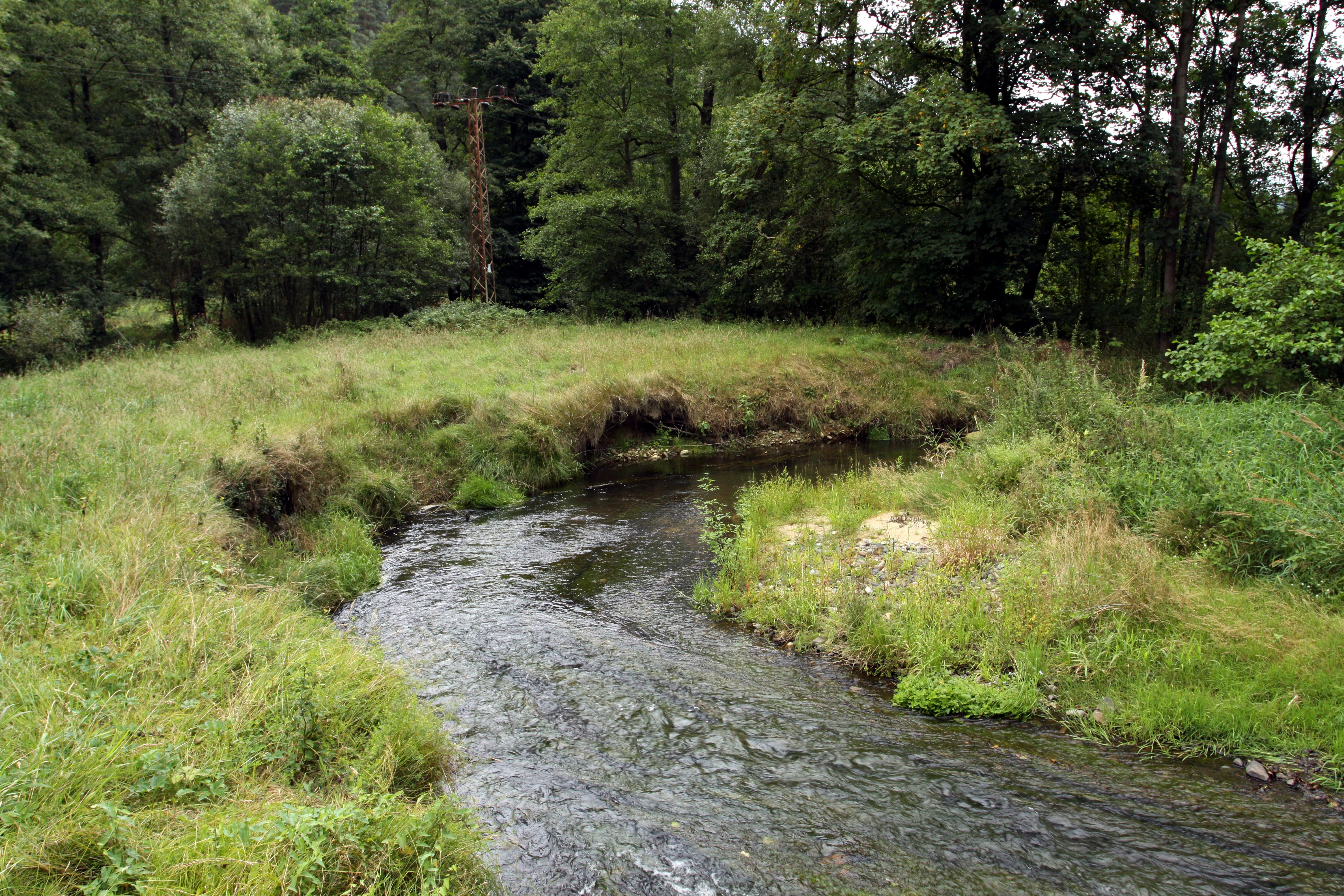
Natural monument Meandry Chribske Kamenice
Meandry Chribske Kamenice natural monument near Jetrichovice in the Decin district, Czech Republic

Meandry Chřibské Kamenice history and protected-area timeline

Meandry Chřibské Kamenice was formally designated as a natural monument on 10 March 1996. The protection was declared by the administration of the former Labské pískovce Protected Landscape Area, which was the broader regional protection framework at the time and the precursor to today's Bohemian Switzerland National Park.

With the creation and expansion of the Bohemian Switzerland National Park, the natural monument became embedded within the management structure of the national park administration. This shift tied its conservation role more closely to the wider sandstone landscape preservation strategy of the region.

Meandry Chřibské Kamenice landscape and geographic character

The monument occupies a small, shallow river valley in the sandstone terrain of northern Bohemia, typical of the Bohemian Switzerland region. The terrain rises gently on either side of the stream, with the river cutting a sequence of meanders through the relatively soft valley floor. Around the channel, vertical banks reveal fresh erosional faces, while broader, flat sandy areas appear where sediment accumulates against the inside of bends.

The floodplain itself is narrow and elongated, following the course of the river between the villages of Všemily and Srbská Kamenice. Thin bands of meadow, marshy patches, and accompanying riparian vegetation run alongside the water, framed by the larger forested sandstone landscape of the surrounding area. This combination of riverine landforms within a sandstone-dominated setting gives the site its distinctive, compact yet visually varied character.

Meandry Chřibské Kamenice ecosystems, habitats, and plant life

Ecologically, the protected area is a floodplain riverine system in miniature. The dominant habitat is the active meander belt of the Chřibská Kamenice, where the flowing water continually reshapes banks, deposits sand, and creates conditions suitable for wet meadows, marshy patches, and strips of accompanying vegetation alongside the channel.

These small habitats together form a network of wet and moist environments that depend on the river's behavior. The floodplain's narrow corridor concentrates habitat diversity within a limited area, supporting plants and animals tied to wet meadows, marshes, and riparian vegetation. The site's location within the larger sandstone landscape of Bohemian Switzerland further links it ecologically to the surrounding forests and rock communities that characterize the wider region.

Meandry Chřibské Kamenice wildlife and species highlights

The natural monument functions as an island of wet habitat within a predominantly forested, sandstone-based landscape. Its combination of flowing water, marshy patches, wet meadows, and riparian vegetation provides refuge for plant and animal species associated with damp, periodically flooded environments. While the site is small, the diversity of microhabitats along the meander corridor allows a comparatively wide range of species to be sustained within its boundaries.

The mosaic of banks, sand bars, and wet surroundings gives the area value as a refuge where riparian communities can persist largely undisturbed by large-scale human intervention. The wider Bohemian Switzerland landscape, into which the monument is integrated, adds further context for the regional wildlife patterns that the stream corridor supports.

Meandry Chřibské Kamenice conservation status and protection priorities

From a conservation perspective, Meandry Chřibské Kamenice represents a deliberate protection of natural river dynamics and their associated habitats within a sandstone landscape. The site's declared purpose explicitly combines the safeguarding of the meandering stream and its floodplain in the section between Všemily and Srbská Kamenice with the preservation of natural processes of river development, including the exposure of vertical banks and the accumulation of sandy flats.

By protecting these processes, the monument maintains the conditions that sustain its wet meadows, marshy biotopes, and accompanying green vegetation, while also preserving an instructive example of how erosion and deposition shape a sandstone river valley. Its incorporation into the administrative framework of the Bohemian Switzerland National Park strengthens the conservation role of the site, ensuring that the broader regional protection strategy complements the local conservation of this small but ecologically rich area.

Monthly climate preview

Long-term representative monthly temperature and precipitation data patterns

Meandry Chřibské Kamenice Climate Normals and Annual Temperature Rhythm

Representative coordinate records show measured long-term temperature swings from sub-zero winter lows to warm summer highs alongside steady monthly precipitation levels. Detailed monthly climate normals provide a complete twelve-month breakdown of weather patterns across the protected landscape.
Annual mean8 °C
-2 °C19 °C
Jan-2°
Feb-1°
Mar
Apr
May13°
Jun17°
Jul19°
Aug19°
Sep14°
Oct
Nov
Dec-1°
Warmest month
July

19 °C

Coolest month
January

-2.2 °C

Wettest month
July

2.9 mm/day

Driest month
April

1.3 mm/day

Park location guide

Geography guide, regional context, and park location map for Meandry Chřibské Kamenice

Meandry Chřibské Kamenice park geography, regions, and map view in Czechia

Understand where Meandry Chřibské Kamenice sits in Czechia through a broader geographic reading of the surrounding landscape, nearby location context, and its mapped position within the national park landscape.

How Meandry Chřibské Kamenice fits into Czechia

Czech Republic is a landlocked Central European country with a population of approximately 10.9 million people. The nation was established as an independent state on January 1, 1993, following the dissolution of Czechoslovakia. Its capital and largest city is Prague, with other major urban centers including Brno, Ostrava, Plzeň, and Liberec.

Wider geography shaping Meandry Chřibské Kamenice in Czechia

The Czech Republic is a landlocked country in Central Europe. It is bordered by Germany to the west, Austria to the south, Poland to the northeast, and Slovakia to the southeast. The landscape is predominantly hilly, with the territory covering 78,871 square kilometers.

Map view of Meandry Chřibské Kamenice

Use this park location map to pinpoint Meandry Chřibské Kamenice in Czechia, understand its exact geographic position, and read its mapped placement within the surrounding landscape more clearly.

Pigeon | © OpenStreetMap contributors

Location context for Meandry Chřibské Kamenice

Ústecký kraj

Visualizing stream meanders, sandstone relief, and riparian habitats

Meandry Chřibské Kamenice Photos and Landscape Scenery

Visual documentation reveals the intricate river meanders, exposed vertical sandstone banks, and narrow floodplains that define the protected terrain of Meandry Chřibské Kamenice. Examining these detailed landscape photographs provides clear insight into active stream dynamics and marshy riparian biotopes within northern Bohemia.

Natural monument Meandry Chribske Kamenice

Park atlas

Compare adjacent river valleys and regional sandstone conservation areas

Parks Near Meandry Chřibské Kamenice and Surrounding Protected Landscapes

Browse nearby national parks and protected areas sharing the distinctive sandstone terrain of northern Bohemia. Extending geographic comparison beyond Meandry Chřibské Kamenice reveals connected regional ecosystems and broader valley formations.
Watercolor illustration of rolling green hills, forests, and distant mountains
National parkCzechia
Mapped location lies within the park boundary#1 closest

West

Bohemian Switzerland National Park: Czech Sandstone Protected Landscape and Map Exploration

Discover its unique terrain and protected area geography.

Bohemian Switzerland National Park is a protected area in the Czech Republic known for its exceptional sandstone geology. This national park showcases a dramatic landscape of towering rock formations, deep gorges, and striking canyons, forming a significant part of the Elbe Sandstone Mountains. Through MoriAtlas, users can explore its mapped protected boundaries, understand its regional geographic context, and appreciate its unique natural heritage.

Area
79 km²
Established
2000
IUCN
II
Relief
Mixed relief
Natural monumentÚstecký kraj
About 3.7 km away#2 closest

Southeast

Sojčí rokle Natural Monument: Atlas and Geography of the Ústecký kraj Sandstone Gorge

A protected ravine sanctuary within the Bohemian Switzerland landscape region.

The Sojčí rokle natural monument features a deep, moist sandstone gorge that sustains a specialized microclimate. Located near Janská in the Ústecký kraj, the site serves as a vital ecological corridor with unique oak-hornbeam forests and rare plant life, representing the intricate rock-carved geography that defines the wider protected landscape of northern Bohemia.

Area
0.035 km²
Established
2016
IUCN
IV
Relief
Upland
Watercolor painting showing a landscape with green hills, trees, and a river winding through the scene
National parkGermany
About 6.2 km away#3 closest

Northwest

Saxon Switzerland National Park: Protected Area Geography and Map Exploration

Discover its mapped boundaries and regional landscape context.

Saxon Switzerland National Park, a protected national park in Germany, offers a distinct focus for geographic and atlas-based discovery. This page details the park's specific protected landscape, its mapped boundaries, and its contribution to the regional geography. MoriAtlas allows for in-depth exploration of such natural areas, providing essential context for understanding their place within broader natural systems and mapped terrains.

Area
93.5 km²
Established
1990
IUCN
II
Visitors
1.7M annual
Nature reserveSachsen
About 15 km away#4 closest

North

Gimpelfang Nature Reserve: Mapped Forest Ecosystems and Protected Terrain in Sachsen

Ancient deciduous stands and brook-valley landscapes.

Gimpelfang is a ten-hectare nature reserve in the Saxon Switzerland district, notable for its mature broadleaf forest that escaped historical spruce planting. The site offers a window into regional ecology with its diverse brook-side ash and alder habitats and strictly protected total-reserve core, providing a dense, research-focused look at native woodland conservation in the German landscape.

Area
0.103 km²
Established
1961
IUCN
IV
Nature reserveLiberec Region
About 17 km away#5 closest

Southeast

Manušické rybníky Nature Reserve and Protected Wetland Landscape in Liberec Region

Historic fishpond mosaic and critical amphibian refuge

Manušické rybníky is a well-documented nature monument in the Czech Republic featuring a chain of seven fishponds established in 1575. The site preserves vital lowland peatland fragments and pine-oak woodlands, serving as a significant ecological node for wetland flora and amphibians within the broader landscape of the Liberec Region.

Area
0.143 km²
Established
2012
IUCN
IV
Relief
Upland
Natural monumentÚstí nad Labem Region
About 18 km away#6 closest

Northeast

Vlčice Natural Monument: Protected Acidophilic Beech Forest in the Ústí nad Labem Region

Mapped upland terrain and old-growth forest conservation

Vlčice represents a highly preserved fragment of old acidophilic beech forest in the northern Czech Republic. Characterized by its granodiorite geology and rolling upland terrain, the site provides a sanctuary for specialized forest species and serves as an important study area for natural woodland development within the broader Ústí nad Labem Region.

Area
0.273 km²
Established
2022
IUCN
IV
Relief
Upland
Nature reserveÚstecký kraj
About 24 km away#7 closest

West

Rájecká rašeliniště Nature Reserve: Protected Peatland and Sandstone Geography in Ústecký kraj

Geographic atlas and protected area landscape summary

Rájecká rašeliniště serves as a critical study in landscape ecology, featuring rare peat-forming vegetation located within the high-relief sandstone formations of the Ústecký kraj. This protected nature reserve provides a unique look at how specialized bog communities thrive despite the porous, water-draining characteristics of the local sandstone terrain, highlighting the site's importance within the Czech conservation landscape.

Area
0.017 km²
Established
2004
IUCN
IV
Water
Major water bodies
Nature reserveLiberec Region
About 24 km away#8 closest

South

Ronov Nature Reserve: Protected Volcanic Geography and Scree Forest Ecosystems in Liberec Region

Volcanic landmark with basalt talus slopes and historic ruins

Ronov rises as a distinctively shaped basalt cone from the rolling terrain of the northern Czech Republic. This nature reserve offers significant insight into the geological and botanical character of the Ralská pahorkatina, featuring extensive stone seas and rare plant habitats situated around ancient castle remains.

Area
0.09 km²
Established
1995
IUCN
IV
Relief
Mountain

Common questions about visiting, size, designation, and location context for Meandry Chřibské Kamenice

Meandry Chřibské Kamenice FAQs for park facts, access, geography, and protected area context

Find quick answers about Meandry Chřibské Kamenice, including protected-area facts, park geography, trail and visitor context, and how the park fits into its surrounding country and regional landscape.
MoriAtlas Explorer

Continue Your Protected Areas Search Across the Global Atlas

Deepen your exploration by continuing the structured search for national parks and protected areas worldwide. Utilize the comprehensive filtering capabilities to compare different conservation landscapes and refine your understanding of global park geography. Discover more about the distribution and characteristics of protected natural areas.

Global natural geography