
Mori Atlas logo
Nature reserveMeißner

Geographic analysis of an extensive upland plateau, forest wilderness, and rare glacial habitats

Meißner Nature Reserve in Hesse: Exploring the Basalt Massif and Protected Forest Landscapes

(Naturschutzgebiet Meißner)

The Meißner nature reserve represents a substantial basalt massif in northern Hesse, characterized by a dramatic high plateau surrounded by steep, densely wooded flanks. This protected territory serves as an essential reference site for ecological research, encompassing near-natural beech forests, mountain meadows, and unique glacial-relict habitats within its basalt blockfields. Users can examine the complex geological layers and conservation boundaries that define this prominent upland feature in central Germany.

beech forestbasalt massifblockfieldsmountain meadowsspring bogNatura 2000
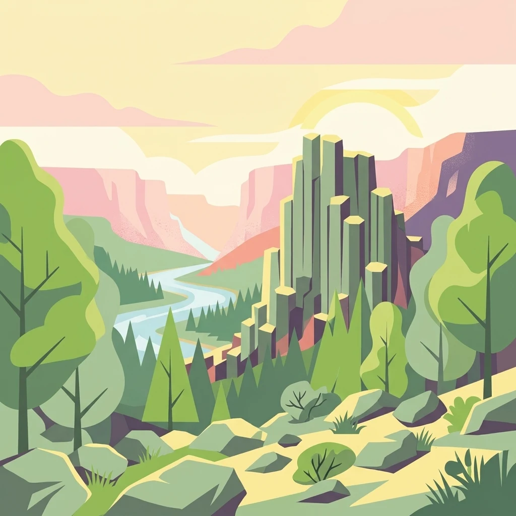
A vibrant, flat-style vector illustration showing a tall basalt rock pillar formation rising above a forest valley with a winding river in the background.

Meißner

Nature reserve

Park overview

Structured park overview, official facts, and landscape profile for Meißner Nature Reserve

Meißner Nature Reserve park facts, protected area profile, and essential visitor context

Review the core facts for Meißner Nature Reserve, including designation, size, terrain, visitor scale, habitats, and operating context in one park-focused overview.

About Meißner Nature Reserve

Meißner Nature Reserve is a large protected forest and habitat complex on the slopes and high plateau of the Hoher Meißner, an isolated lava-dome-like massif that rises several hundred meters above the surrounding Werra and Fulda hill country. The reserve is administered under German nature reserve law as a Habitat/Species Management Area, embedded in European Natura 2000 protection, and includes a strict forest wilderness reference where no forestry activity is permitted.

The reserve's identity is shaped by geology: a thick basalt cap, once interpreted as a relic volcanic feature but now understood as a shallow intrusive lava body, forms a flat high plateau whose edges fall away in steep, often block-strewn slopes. The hard basalt, the softer Triassic sedimentary rocks beneath it, and the legacy of centuries of brown coal mining have combined to produce an unusually varied mosaic of forest types, open meadows, peatlands, and rocky habitats within a relatively compact area.

Ecologically, the site bridges lowland and sub-mountain forest communities. Beechwoods of several types anchor the woodland, while species-rich ravine and slope forests on basalt scree harbor rare ferns, including the only Hesse population of Braun's holly fern. Open habitats add further value: traditionally grazed mountain meadows with wood cranesbill, globe-flower, and large pink, peatlands with cottongrass and bog mosses around the Weiberhemd and Butterwiese, and naturally rocky blockfields where arctic-alpine mosses and clubmosses survive as Ice Age relicts. A small natural pond, the Frau-Holle-Teich, lends the reserve a distinct wetland character.

The reserve's conservation role extends beyond local biodiversity. It anchors a Natura 2000 site of significant size and includes a contiguous bird protection area covering thousands of hectares of forest and adjacent land. Its accessibility from several surrounding municipalities, together with its infrastructure of marked paths and a state road crossing the plateau, makes it both an ecological stronghold and an important natural area for residents and visitors in northern Hesse.

Quick facts and research context for Meißner Nature Reserve

The Meißner Nature Reserve lies in the Werra-Meißner-Kreis of northern Hesse and protects the steep flanks and parts of the plateau of the Hoher Meißner basalt massif, an iconic upland in the Fulda-Werra-Bergland. It is classified as an IUCN Category IV habitat and species management area and was legally established in 1989, after an earlier 1970 designation of a smaller zone.

It is one of Hesse's largest nature reserves, the state's largest forest-focused reserve, and the principal component of the Natura 2000 site 'Meißner und Meißner Vorland' and the bird protection area 'Meißner'. A core forest wilderness reserve is embedded within its borders, preserving beechwoods, ravine mixed forests, and one of Hesse's only known stands of Braun's holly fern.

Protection and recognition

Documented terrestrial boundaries, management scope, and Natura 2000 records.

Meißner Protection Status and International Recognition Data

Terrestrial protection status records for Meißner outline official management scope and formal boundaries. Documented international recognition data includes verified Natura 2000 entries.

International recognition

Protection details

Protection scope
Terrestrial
Transboundary protection
No
WDPA ID
6969
Park context

Deeper park guide and search-rich context for Meißner Nature Reserve

Meißner Nature Reserve history, landscape, wildlife, and travel context

Explore Meißner Nature Reserve through its history, landscape character, ecosystems, wildlife, conservation priorities, cultural context, and seasonal travel timing in a structured park guide built for atlas discovery and search intent.

Why Meißner Nature Reserve stands out

The reserve is best known for its concentration of contrasting habitats on a single basalt massif: thick basalt-capped plateau, naturally tree-free blockfields of Ice Age origin, nutrient-poor mountain meadows colored by wood cranesbill, and a rare hanging spring bog. It is particularly celebrated among ecologists for its glacial relict species and forest communities that combine montane, sub-Atlantic, and Central European elements. Dramatic columnar basalt formations such as the Seesteine, the natural Frau-Holle-Teich pond, and the Weiberhemd bog give the reserve an unusually varied landscape profile for central Germany. The protected area also serves as a reference site for near-natural beech forest development, with parts of the forest left entirely untouched as a wilderness reference.
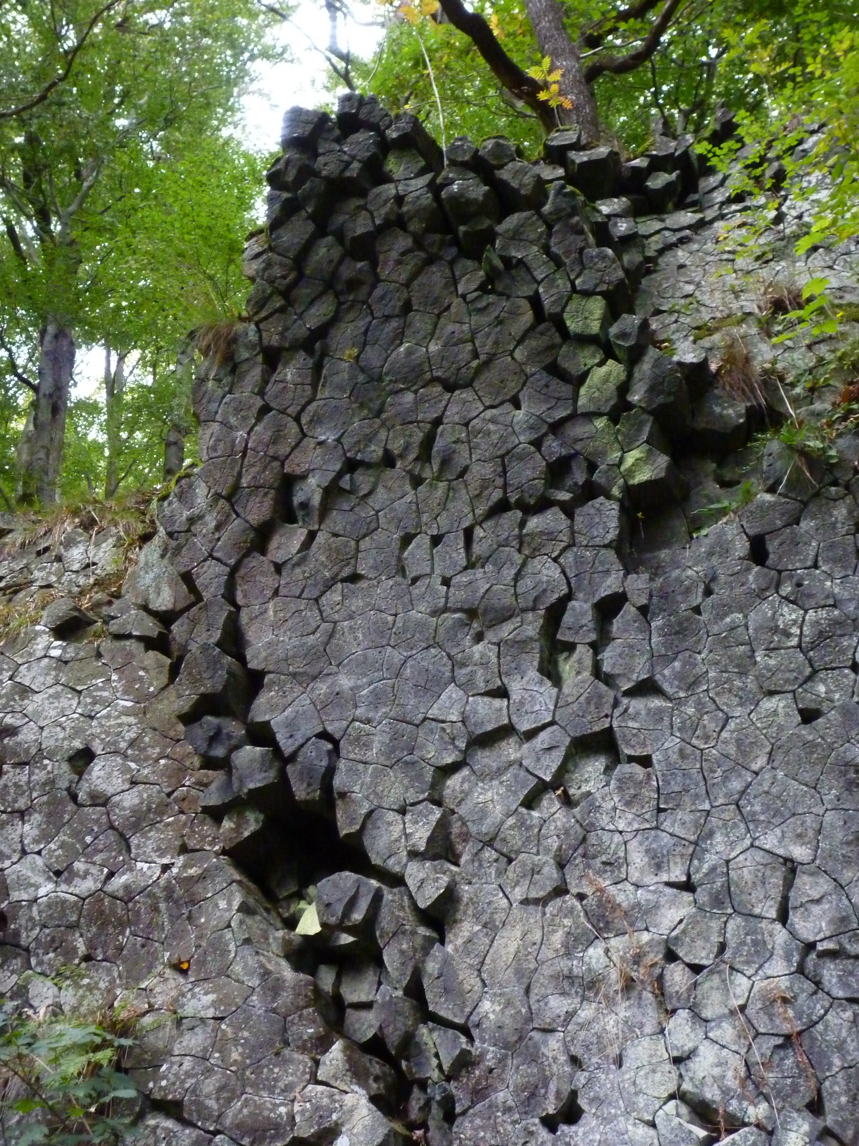
A close-up view of dark, hexagonal basalt columns forming a vertical cliff face, framed by green forest foliage.
The distinctive columnar basalt formations of the Kitzkammer at Hoher Meißner.

Meißner Nature Reserve history and protected-area timeline

Protection of the Meißner's most striking features dates back to 1921, when a Prussian administrative order placed landmark elements, the Frau-Holle-Teich pond, the Weiberhemd bog, the Seesteine cliffs, and the Kalbe, under early safeguards. After the German Imperial Nature Conservation Law of 1935, these small areas were reclassified as natural monuments rather than large nature reserves, leaving the wider massif unprotected through much of the mid-twentieth century.

Responding to the threat of expanding brown coal mining, conservationists applied already in 1951 for a comprehensive nature reserve on the Meißner, but the proposal was blocked for years by unsettled brown coal reserves beneath the plateau. Following the eventual closure of the Kalbe opencast mine in 1974, a first formal nature reserve was established in 1970 covering 720 hectares. The reserve in its current 930-hectare extent was designated in 1989.

In 1988, a forest wilderness reserve was established on the eastern slopes, comprising an unmanaged total reserve and two reference plots managed under near-natural forestry. The Meißner and Meißner Vorland site became a legally binding Natura 2000 area in January 2008, merging management planning with that of the surrounding bird protection area. Today, the larger European-level plans govern reserve management, replacing an earlier site-specific plan.

Meißner Nature Reserve landscape and geographic character

The reserve is defined by the dramatic profile of the Hoher Meißner: an almost level basalt plateau roughly 100 to 150 meters thick, ringed by steep slopes that drop sharply on all sides into the surrounding Werra-Meißner hill country. The plateau stands as a geological outlier within the Fulda-Werra-Bergland, its hard volcanic cap having resisted erosion while softer Triassic sediments beneath it were worn away.

Along the plateau edge, basalt cliffs of columnar jointing and extensive blockfields dominate. The Seesteine cliffs and large scree slopes belong to the most visually striking features, with basalt blocks ranging from decimeters to about a meter across. These rocky slopes are naturally inhospitable to soil and tree cover, producing clearings and cold microclimates within an otherwise forested massif.

The flanks of the mountain reveal the layered geology of the area: Triassic sandstones on the east and south, limestone of the Muschelkalk on the west, and unconsolidated Tertiary clays and sands wedged between these older rocks and the basalt cap. These brown-coal-bearing Tertiary layers once fueled centuries of underground mining, leaving the present-day Kalbe pit lake, deliberately excluded from the reserve, as a visible industrial legacy on the plateau.

A state road crosses the protected area itself along the plateau, while forest tracks and trails descend through beech and ravine forest, opening onto meadows and bogs near the slopes. Overall, the landscape of the Meißner reserve looks like an island mountain: a flat, basaltic crown with abrupt wooded flanks, sprinkled with rocky outcrops, small mires, and a single natural pond.
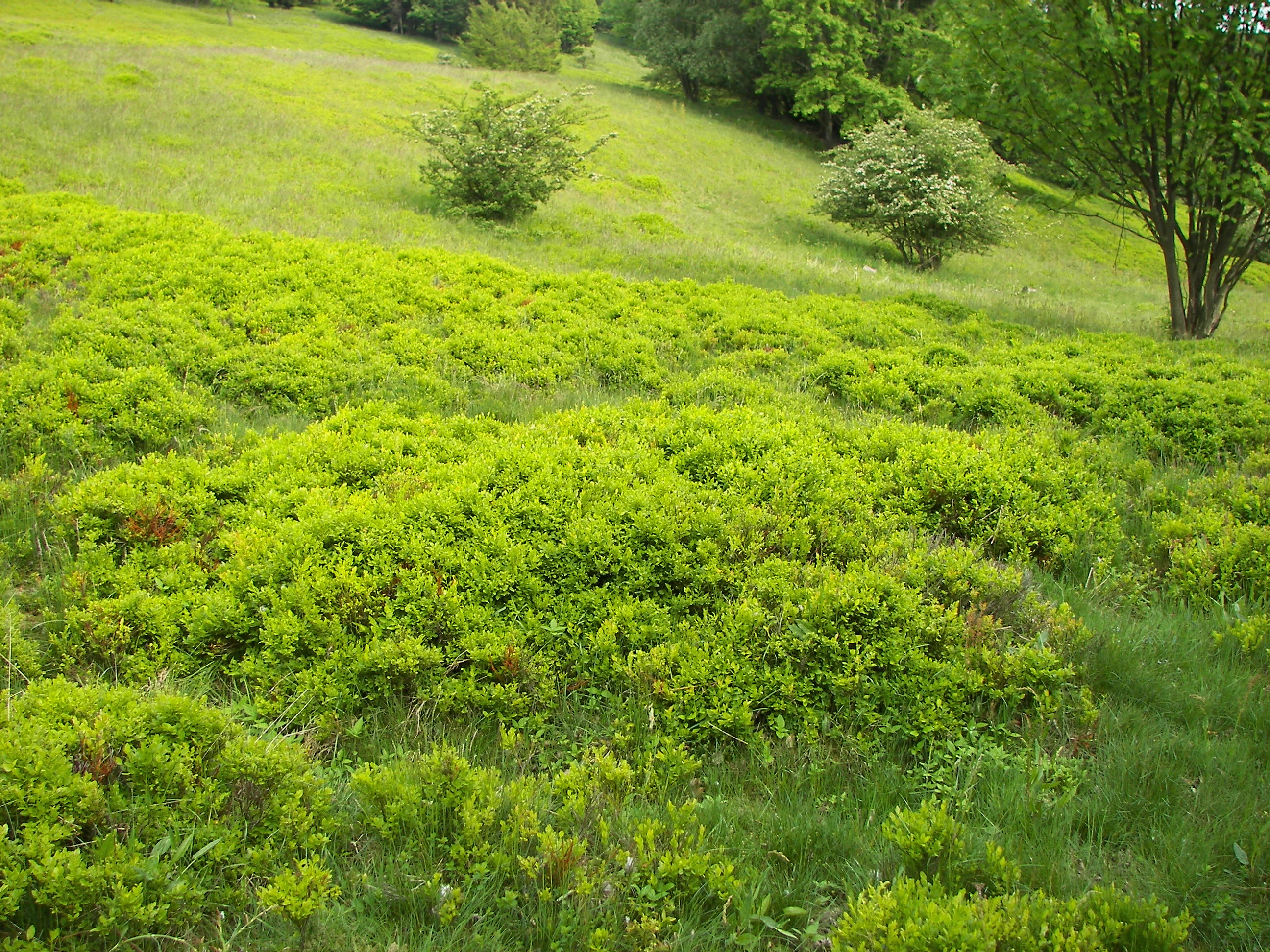
A sloped grassy meadow covered with patches of low, bright green blueberry bushes and scattered shrubs under overcast lighting.
A patch of low-growing blueberry heath on the slopes of the Hoher Meißner.

Meißner Nature Reserve ecosystems, habitats, and plant life

The site is primarily a forest reserve, with native deciduous woodland covering the vast majority of its area. Beech is the dominant genus throughout, expressed in a striking diversity of forest types tied to subtle differences in substrate, slope, and soil chemistry. On basaltic soils of moderate nutrient status, the woodruff beechwood forms the principal community; on poorer, often leached substrates, the more species-poor acid beechwood takes over; and on the small areas of limestone and richer basalt, the barley-type beechwood occurs.

Distinctive within Hesse are the ravine and slope-mixed forests that develop on the finer-earth pockets of basalt scree. These stands mix sycamore maple, ash, wych elm, and large-leaved lime, with alpencurrant in the shrub layer and a fern-rich herb layer. Among these ferns is the Braun's holly fern, whose only Hessian locality lies in this very habitat and is the focus of an active species protection program led by the local forestry office.

Non-forest habitats add ecological depth. The Weiberhemd is a hanging spring bog with peat up to two meters thick, carrying alder carr, sedge communities, and Sphagnum moss formations of mesotrophic character, alongside rare species such as cottongrass and purple small-reed. Two smaller mires, the Seewiese and the Butterwiese, contribute additional peatland habitat, the latter still hosting extensive cottongrass stands.

Mountain meadows preserved as traditional grazing land, especially around the Hausener Hute, are species-rich mosaics of mat-grass swards, dwarf-shrub heath, wet grassland, and small-sedge communities. They harbor regionally rare montane plants, including wood cranesbill, globe-flower, large pink, and alpine bedstraw, with arnica and heath dog-violet as characteristic species of the more nutrient-poor stands.

Meißner Nature Reserve wildlife and species highlights

As a forest-dominated reserve, the Meißner is primarily a habitat for forest-dwelling species typical of central German low and mid-mountain woodlands. While the article describes vegetation and plant communities in detail, the reserve's bird, mammal, and invertebrate faunas are protected through its inclusion in the European bird protection area 'Meißner'. The protected forest stands, particularly the unmanaged wilderness reference, support species that depend on aging trees, deadwood, and structurally diverse canopies.

The traditional meadows, especially the Hausener Hute and surrounding pastures, support pollinator communities that depend on the rich flowering of mountain hay meadows and mat-grass swards. Bog communities around the Weiberhemd and Butterwiese sustain wetland invertebrates and plants adapted to spring-fed, peat-forming conditions.

Although the source material emphasizes plants rather than fauna, the reserve's combination of mature broadleaf forest, open rocky slopes, mire, and pond makes it ecologically diverse enough to support forest birds, woodland mammals, and drought-sensitive invertebrate assemblages typical of Hessian uplands. The bird protection area designation reflects this broader faunal value across a much larger footprint than the core reserve.

Meißner Nature Reserve conservation status and protection priorities

Meißner is a centerpiece of Hesse's conservation landscape. As the largest forest nature reserve in the state and one of Hesse's largest nature reserves overall, it concentrates a rare combination of near-natural deciduous forest, naturally tree-free rocky habitat, traditional meadows, and peatland within a single protected boundary. Its IUCN Category IV status, sharpening its role as a habitat and species management area, makes active maintenance of the open habitats, such as the Hausener Hute meadows, part of its formal mandate.

The reserve is fully embedded in the Natura 2000 network. It is the principal component of the FFH site 'Meißner und Meißner Vorland' and lies within the bird protection area 'Meißner', which together cover a much larger landscape of forest and surrounding farmland. A joint management plan under Natura 2000 now governs the reserve, replacing earlier site-specific planning. A forest wilderness reserve set aside in 1988 provides an unmanaged baseline stand alongside two near-natural reference plots, allowing long-term comparison of forestry-free versus traditionally managed beech and ravine forests.

At the species level, the reserve hosts important populations of nationally and regionally rare plants, including Braun's holly fern, whose Hessian survival depends on the mosaic of ravine forest and basalt scree here. Specific programs at the local forestry office are dedicated to maintaining its habitat. Mires, traditionally grazed meadows, and boulder-field moss communities are also managed to keep their characteristic species composition intact against succession and past over-collection.

Meißner Nature Reserve cultural meaning and human context

The Meißner's upland meadows and wood-pastures reflect a long tradition of communal grazing. Areas such as the Hausener Hute and Viehhaushute once served as village commons where livestock shaped the vegetation. Today, conservation management continues this grazing tradition in modified form to preserve the cultural landscape and its botanical richness.

The reserve also lies within a region strongly shaped by centuries of brown coal mining beneath the basalt cap. The Kalbe pit lake, the closed surface mine, and the old tunnels evoke centuries of resource extraction that once threatened the mountain itself. Conservationists had to fight off renewed opencast proposals in the 1970s before the area could be formally protected.

Local place names weave through the reserve's geography. Weiberhemd, named for its tapering shape on old maps, and the Frau-Holle-Teich, a natural pond whose name ties it to the regional folklore of Frau Holle, connect the protected area to the cultural memory and storytelling of northern Hesse. Small villages and town districts of Bad Sooden-Allendorf, Großalmerode, Hessisch Lichtenau, Berkatal, and the municipality Meißner all border or lie within the reserve's mosaic.

Top sights and standout views in Meißner Nature Reserve

The Meißner reserve concentrates several exceptional features in one mountain: Ice Age basalt blockfields with naturally tree-free clearings, three small but ecologically rich peatlands including the Weiberhemd hanging spring bog, a natural mountain pond in the Frau-Holle-Teich, and species-rich traditionally grazed meadows. Across the same mountain, a near-natural beech forest mosaic of woodruff, acid, and barley types meets ravine mixed forest harboring Hesse's only population of Braun's holly fern.

The reserve also stands out for its strict protection gradient, pairing a long-standard nature reserve with a dedicated wilderness forest reference, and integrating tightly with European Natura 2000 and bird protection area frameworks. Geologically, the site offers accessible views of columnar basalt, basalt scree, and the layered Triassic and Tertiary sedimentary basement that historically hosted brown coal mining.

Best time to visit Meißner Nature Reserve

Late spring and early summer are typically the most rewarding periods to experience the reserve, when the traditionally grazed mountain meadows around the Hausener Hute come into flower. Wood cranesbill, globe-flower, large pink, and arnica color the open swards during this window, and the deciduous canopy is fully open.

Late summer and early autumn bring crisper air, ripening forest fruits, and good viewing conditions for the basalt blockfields as foliage thins along the plateau edge. Cooler conditions also highlight the cold-air microclimate of the boulder fields. Winter visits can reward visitors with views of the columnar basalt cliffs and fog-filled valleys below the plateau, though paths may be icy and the high plateau can be harsh in foul weather. Year-round, the protected area supports varied forest walking, with the Beberbeck state road crossing providing landscape-scale vistas across the Fulda-Werra hill country.

Monthly climate preview

Track representative annual temperature ranges and precipitation patterns across the protected landscape

Meißner Climate Normals and Long-Term Weather by Month

Historical climate data for Meißner documents a wide annual temperature span from subzero winter minimums to warm summer maximums alongside steady monthly precipitation levels. Exploring the comprehensive twelve-month profile reveals detailed long-term averages across all individual recorded cycles.
Annual mean8 °C
-1 °C18 °C
Jan-1°
Feb
Mar
Apr
May12°
Jun16°
Jul18°
Aug18°
Sep14°
Oct
Nov
Dec
Warmest month
July

18.3 °C

Coolest month
January

-1.1 °C

Wettest month
July

2.6 mm/day

Driest month
April

1.4 mm/day

Park location guide

Geography guide, regional context, and park location map for Meißner Nature Reserve

Meißner Nature Reserve park geography, regions, and map view in Germany

Understand where Meißner Nature Reserve sits in Germany through a broader geographic reading of the surrounding landscape, nearby location context, and its mapped position within the national park landscape.

How Meißner Nature Reserve fits into Germany

Germany is a federal republic in Western and Central Europe with a population of over 83 million across sixteen constituent states. It is Europe's largest economy by nominal GDP and a major global exporter and importer. The capital is Berlin, and the country borders Denmark, Poland, Czech Republic, Austria, Switzerland, France, Luxembourg, Belgium, and the Netherlands.

Wider geography shaping Meißner Nature Reserve in Germany

Germany is located in Western and Central Europe, spanning 357,022 km². It borders Denmark to the north, Poland and the Czech Republic to the east, Austria and Switzerland to the south, and France, Luxembourg, Belgium, and the Netherlands to the west. The country has coastlines on the Baltic Sea and North Sea to the north, with the Alps located in the southern region.

Map view of Meißner Nature Reserve

Use this park location map to pinpoint Meißner Nature Reserve in Germany, understand its exact geographic position, and read its mapped placement within the surrounding landscape more clearly.

Pigeon | © OpenStreetMap contributors

Location context for Meißner Nature Reserve

Hesse
Recorded earthquake history

Review Recorded Earthquake History and Seismic Data for the Meißner Nature Reserve

Explore a historical collection of seismic events recorded in the vicinity of the Meißner Nature Reserve. This catalogue organizes data by epicentre distance, providing a transparent look at past seismic activity throughout the regional landscape using MoriAtlas records.

Meißner Earthquake History

Catalogued events

3 events

Strongest magnitude

Magnitude 3.6

Most recent event

Sep 22, 2005

This history includes earthquakes recorded inside the park or within 50 km of its borders

Visualizing basalt massifs, ancient blockfields, and forest habitats across the upland terrain

Meißner Photos and Protected Landscape Scenery in Northern Hesse

Protected area photography reveals the dramatic volcanic topography, columnar basalt cliffs, and ancient blockfields that define the upland massif. Visual records of the beech forests, hanging bogs, and mountain meadows offer direct insight into the ecological character of the region.

A close-up view of dark, hexagonal basalt columns forming a vertical cliff face, framed by green forest foliage.

A wide view of a rocky block field strewn with large basalt stones, interspersed with green deciduous trees and shrubs under a hazy sky.

A sloped grassy meadow covered with patches of low, bright green blueberry bushes and scattered shrubs under overcast lighting.

Park atlas

Compare surrounding upland landscapes and adjacent protected habitats across northern Hesse

Explore Protected Areas and Parks Near Meißner in Regional Context

Continue exploring regional protected areas and mountain forests adjacent to Meißner for broader geographic comparison. Examining nearby reserves reveals how basalt massifs and upland ecosystems connect across the surrounding hill country.
A soft, light-colored watercolor painting of a rolling hilly landscape with sparse trees and open grassy meadows.
Nature reserveWerra-Meißner-Kreis
Mapped location lies within the park boundary#1 closest

Northwest

Bühlchen bei Weißenbach Nature Reserve: Protected Limestone Grasslands in Werra-Meißner-Kreis

Geographic atlas of a historic juniper heath and limestone hilltop.

Bühlchen bei Weißenbach represents a rare, semi-open cultural landscape shaped by centuries of sheep grazing on shell limestone summits. This nature reserve, integrated into the Natura 2000 network, offers a dense concentration of rare orchids and gentians across its rocky, nutrient-poor slopes, serving as a critical site for regional ecological study and landscape preservation.

Area
0.08 km²
Established
1985
IUCN
IV
Relief
Mountain
A watercolor painting showing a soft, green landscape with gentle rolling hills, small clusters of trees, and a small meandering stream, framed by delicate wild flowers in the foreground.
Nature reserveWerra-Meißner-Kreis
About 0.1 km away#2 closest

West

Quellgebiet der Weißen Gelster: Nature Reserve Geography and Protected Area Mapping

Calcareous spring mires and wet meadows in Werra-Meißner-Kreis

Located at the foot of the Meinetsberg, Quellgebiet der Weißen Gelster features a series of groundwater-dependent habitats including Davall's sedge fens and golden oat meadows. The reserve represents a key segment of the regional protected-area network, preserving rare vegetation types on Keuper bedrock within a characteristic upland agricultural valley.

Area
0.115 km²
Established
1991
IUCN
IV
Relief
Upland
Watercolor illustration showing rolling green hills, small clusters of trees, and tall grasses in the foreground against a soft white background.
Nature reserveWerra-Meißner-Kreis
1 km away#3 closest

Southwest

Reichenbacher Kalkberge Nature Reserve: Geographic and Protected Landscape Analysis

Muschelkalk limestone hills and orchid-rich grassland habitats

An essential look at the Reichenbacher Kalkberge protected area, where limestone-based forest stands meet rare semi-dry meadows. Gain geographic insight into the terrain, the medieval castle ruin surroundings, and the protected habitat mosaic that defines this distinctive part of the Geo-Naturpark Frau-Holle-Land.

Area
1.503 km²
Established
1996
IUCN
IV
Relief
Mountain
A horizontal watercolor painting showing a soft, muted landscape with rolling hills, a central open area, and clusters of green trees under a pale sky.
Nature reserveWerra-Meißner-Kreis
About 1.5 km away#4 closest

Northeast

Kripp- und Hielöcher Nature Reserve: Karst Geography and Protected Land in Werra-Meißner-Kreis

Geology-focused nature reserve featuring gypsum sinkholes and dry grasslands.

Kripp- und Hielöcher provides a rare look at Zechstein gypsum karst in Hesse. The reserve is split into two distinct areas, the Kripplöcher and Hielöcher, showcasing natural rock monuments, active karst springs, and a historical cultural landscape maintained through centuries of traditional land use.

Area
0.17 km²
Relief
Upland
Climate
Temperate
Access
Moderate access
A horizontal watercolor illustration depicting rolling green hills, scattered trees, and soft mountain silhouettes against a pale sky.
Protected areaGermany
4.8 km away#5 closest

North

Kalkmagerrasen bei Roßbach: Protected Calcareous Grassland and Juniper Landscape in Germany

Geographic atlas and protected area overview in Hesse

Kalkmagerrasen bei Roßbach consists of five distinct plots that protect rare Enzian Schillergras Rasen communities on shallow Zechstein limestone soils. This site remains a critical stronghold for diverse orchid populations and protected butterfly species within the Werra Meißner region. The mosaic of juniper, flowering herbs, and historic cherry orchards creates a unique Mediterranean character rarely found in central German hill country.

Area
0.551 km²
Established
1996
Relief
Upland
Climate
Temperate
A soft, minimalist watercolor painting of rolling hills and trees set against a white background.
Nature reserveHessen
4.9 km away#6 closest

East

Bilstein im Höllental: Protected Diabase Cliff and Ravine Forest in Hessen

Geological landscape and Natura 2000 protected area

Discover the geographic significance of Bilstein im Höllental, a nature reserve in the Werra-Meißner-Kreis that showcases a rare juxtaposition of warm rock refuges and cool, shaded ravine environments. The reserve protects significant cliff-dwelling plant communities and traces of medieval history upon its 284-meter diabase summit, providing a focused example of geological resistance shaping valley terrain.

Area
0.032 km²
Established
1960
IUCN
IV
Relief
Mountain
Watercolor painting of a pastoral landscape with light green hills in the distance, a field with flowering pink trees, and a pale green meadow in the foreground.
Nature reserveWerra-Meißner-Kreis
6.6 km away#7 closest

North

Ebenhöhe-Liebenberg Nature Reserve: Geography and Protected Habitat Mapping

Protected calcareous forests and dry grassland mosaic

Explore the mapped boundaries and natural terrain of the Ebenhöhe-Liebenberg nature reserve. This site provides a critical habitat mosaic including orchid-rich beech woodlands, nutrient-poor grasslands, and sandstone outcrops that form a significant conservation area within the Hessian highlands.

Area
142.48 km²
Established
1995
IUCN
IV
Relief
Upland
A wide watercolor illustration of a rolling landscape with green fields, patches of pink flowers, and distant purple hills under a pale sky.
Nature reserveWerra-Meißner-Kreis
About 7.5 km away#8 closest

East

Jestädter Weinberg: Protected Zechstein Cliffs and Werra River Valley Mosaic

A botanical and geological hotspot in northern Hesse

Jestädter Weinberg represents a critical protected landscape defined by its steep dolomite rock faces and sun-exposed slopes. This nature reserve provides an essential habitat for orchids and diverse insect populations, bridging the gap between high-altitude limestone ridges and the riparian meadows of the Werra river valley.

Area
0.6 km²
Established
1924
IUCN
IV
Relief
Upland

Common questions about visiting, size, designation, and location context for Meißner Nature Reserve

Meißner Nature Reserve FAQs for park facts, access, geography, and protected area context

Find quick answers about Meißner Nature Reserve, including protected-area facts, park geography, trail and visitor context, and how the park fits into its surrounding country and regional landscape.
MoriAtlas Explorer

Continue Your Protected Areas Search Across the Global Atlas

Deepen your exploration by continuing the structured search for national parks and protected areas worldwide. Utilize the comprehensive filtering capabilities to compare different conservation landscapes and refine your understanding of global park geography. Discover more about the distribution and characteristics of protected natural areas.

Global natural geography