

Mori Atlas logo
Natural monumentMikulovické jezero

Analyzing the ecological footprint of this rare precipitation fed upland basin

Mikulovické jezero Natural Monument: Mapped Protected Landscapes and Regional Geography

Mikulovické jezero sits as a distinctive natural monument within the South Moravian Region, characterized by its rare hydrology as a precipitation fed upland basin. Positioned on the flat spur of the Výrovická pahorkatina, the protected area maintains a fragile wetland environment that supports unique halophilic plant communities. Through its mapped boundaries and topographic context, this site offers insights into the specialized saline habitats occurring within the broader agricultural landscape of the Czech Republic.

natural lakeupland basinwetlandhalophilic vegetationsaline habitatbirdwatching
A stylized vector illustration of a river winding through a wetland valley with a waterfall in the background, framed by willow branches.

Mikulovické jezero

Natural monument

Park overview

Structured park overview, official facts, and landscape profile for Mikulovické jezero

Mikulovické jezero park facts, protected area profile, and essential visitor context

Review the core facts for Mikulovické jezero, including designation, size, terrain, visitor scale, habitats, and operating context in one park-focused overview.

About Mikulovické jezero

Mikulovické jezero is a compact but ecologically distinctive protected site in the South Moravian countryside of the Czech Republic, occupying a shallow basin on the plateau known as Jezera, part of the Výrovická pahorkatina within the Znojemská pahorkatina hill country. Although the surrounding region is dominated by farmland and gentle rolling terrain, the protected basin stands out for its combination of permanent open water, wetland margins, and soil chemistry unusual for central Moravia.

The lake itself is a natural rainwater-filled depression with no permanent outflow. Water levels fluctuate with precipitation and evaporation rather than inflow from streams, which is one of the reasons the site is considered unusual at the national scale. This isolation from running water has allowed specialized plant communities to develop along the shore, particularly those associated with saline conditions. The flat, elevated setting, far from any river valley, reinforces the impression of an isolated pocket of distinctive habitat.

The protected designation was established on 8 April 1999 as a přírodní památka, or nature monument, a category used in the Czech system to protect smaller sites of high natural value. At roughly 2.66 hectares, the territory is small, but the protection focuses on the water body, its wetland margins, and the rare species that depend on this combination. In the broader hierarchy of Czech nature conservation, the site is managed at the regional level through the Regional Authority of the South Moravian Region.

Today, Mikulovické jezero is valued primarily as a quiet ecological refuge and a study site rather than a major scenic destination. It sits near a red-marked hiking trail between Výrovice and Višňové, and a publicly accessible bird observation hide was built on the western shore in 2007, making it easier for visitors to experience the wildlife value of the area without disturbing the sensitive habitats along the shoreline.

Quick facts and research context for Mikulovické jezero

Mikulovické jezero is a nature monument (přírodní památka) located in the Znojmo District of the South Moravian Region, east of the market town Mikulovice. The protected area was established on 8 April 1999 and covers approximately 2.66 hectares at an elevation of roughly 356 metres above sea level. Administratively it sits at the level of a regional protected category for a habitat and species occurrence site, corresponding to IUCN Category IV.

The site is notable in the Czech context as one of the rare instances of a natural upland lake filling a shallow depression on a plateau rather than a river valley. The basin is rain-fed, has no permanent outflow, and is influenced by saline soil conditions that have shaped an unusual local flora. Even by Moravian standards, this combination of open water, wetland margin, and halophilic vegetation is uncommon.

Protection and recognition

Examine the documented protection status and designated conservation scope for this protected area.

Mikulovické jezero Protection Status and Terrestrial Conservation Scope

Mikulovické jezero maintains a documented terrestrial protection scope within the regional conservation network. Structured facts outline the recorded designation framework and official management criteria associated with the landscape.

Protection details

Protection scope
Terrestrial
Transboundary protection
No
Park context

Deeper park guide and search-rich context for Mikulovické jezero

Mikulovické jezero history, landscape, wildlife, and travel context

Explore Mikulovické jezero through its history, landscape character, ecosystems, wildlife, conservation priorities, cultural context, and seasonal travel timing in a structured park guide built for atlas discovery and search intent.

Why Mikulovické jezero stands out

Mikulovické jezero is best known for being one of the few natural upland lakes in the Czech Republic and for the saline-influenced wetland vegetation that has developed around its shores. The basin sits on the high ground of the Výrovická pahorkatina rather than in a typical river-fed valley, and it is fed only by precipitation, giving it a distinctive hydrology. Equally important botanically is the saline plant community that has formed under these unusual conditions, a feature otherwise rare in this part of Moravia. Together, the natural rainwater lake and the halophilic flora around it make the site a focused ecological hotspot within an otherwise unremarkable agricultural landscape, drawing interest from botanists, wetland ecologists, and birdwatchers.
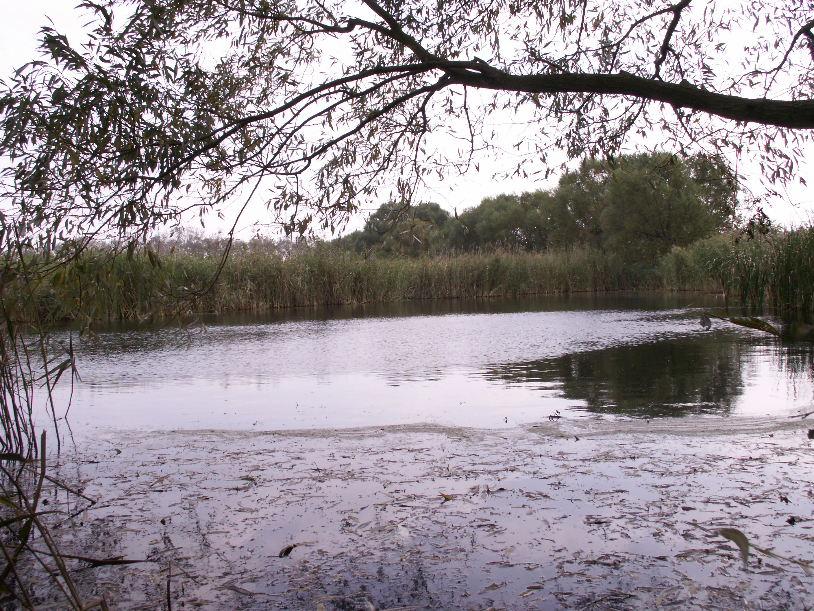
A calm, dark-watered pond framed by overhanging willow branches in the foreground, with dense reeds and trees along the distant bank.
A view of the Mikulovické jezero natural monument, characterized by its pond and surrounding wetland vegetation.

Mikulovické jezero history and protected-area timeline

Mikulovické jezero gained formal protection on 8 April 1999, when it was declared a přírodní památka (nature monument) under Czech conservation law. The designation recognized both its status as a rare natural upland lake in the Czech context and the unusual plant and animal communities that had developed around its saline-influenced shores within the Znojemská pahorkatina.

In 2007, a publicly accessible bird observation hide was constructed on the western side of the lake, marking a shift toward making the scientific and ecological value of the site more accessible to visitors while also supporting ongoing monitoring of the waterbirds and other fauna that use the basin. Apart from this infrastructure addition, the site's history is that of a long-protected but otherwise low-profile natural feature within the agricultural landscape south of Znojmo.

Mikulovické jezero landscape and geographic character

The landscape setting of Mikulovické jezero is defined by the gently rolling, flat-topped terrain of the Výrovická pahorkatina, part of the broader Znojemská pahorkatina hill country in southwestern Moravia. The protected basin itself lies on a level rise called Jezera, where a shallow topographic depression has filled with rainwater to form a small open lake with no permanent inlet or outlet.

The surrounding countryside is dominated by agricultural land and orchards, with the lake basin set within an adjacent orchard area east of the market town of Mikulovice. Inland cliffs, dramatic relief, and large water bodies are absent; instead, the visual character is shaped by open fields, the visible bowl of the lake basin, and the wetland fringe that softens the transition between open water and the cultivated plateau. A controlled outflow structure exists on the western end of the lake, reflecting the managed yet naturalistic character of the setting.

Mikulovické jezero ecosystems, habitats, and plant life

The ecological value of Mikulovické jezero is rooted in the unusual convergence of an upland rainwater lake, wetland margins, and saline soil conditions within a small area of South Moravia. The basin functions as a permanent open-water habitat in a landscape where such features are otherwise scarce, while the surrounding wet ground supports a mosaic of marsh and hygrophilous communities.

Most distinctive is the halophilic plant community that has developed under the influence of natural salinity, an ecological pattern highly unusual in this part of the Czech Republic. The combination of permanent water, seasonal drawdown, and saline substrates produces a layered microhabitat structure around the shore, with different plant communities occupying slightly different elevations and moisture regimes. The result is a compact ecological mosaic that supports rare species in unusually high local densities relative to the small size of the site.

Mikulovické jezero wildlife and species highlights

The wildlife interest of Mikulovické jezero centers on the species associated with open water, wetland margins, and the saline-influenced plant communities around the basin. Waterbirds are a particularly important group, given the persistent open water and the surrounding marshy ground, and the site's birdwatching infrastructure on the western shore reflects this ornithological value.

The protected designation also emphasizes rare animal species more broadly, recognizing the basin as a localized refuge in an otherwise heavily used agricultural landscape. The combination of stable water levels, undisturbed shoreline vegetation, and unusual soil chemistry gives the site a role disproportionate to its size in supporting species that are uncommon elsewhere in Moravia.

Mikulovické jezero conservation status and protection priorities

Mikulovické jezero is protected as a přírodní památka, a category in the Czech system designed to conserve smaller sites of significant natural value. The official justification for protection highlights the water and wetland biotope, rare animals, and rare plants, treating the basin as an integrated ecological unit rather than just a scenic feature.

Its conservation importance rests on three factors: the rarity of natural upland lakes in the Czech Republic, the unusual saline-influenced vegetation that has developed around the shore, and the resulting concentration of rare species within a very small protected footprint. Although the site is tiny in absolute terms, the level of habitat specialization it preserves makes it disproportionately valuable for biodiversity conservation at the regional level, and it is one of the more illustrative examples of how small Czech protected areas can preserve ecological features absent from the broader landscape.

Top sights and standout views in Mikulovické jezero

Mikulovické jezero stands out as a rare example of a natural upland lake in the Czech Republic, formed in a shallow depression on a plateau rather than in a river valley and fed solely by precipitation. Its defining highlight is the saline-influenced plant community that encircles the shore, a feature otherwise uncommon in this part of Moravia.

A second, more visitor-oriented highlight is the publicly accessible bird observation hide on the western shore, built in 2007, and the proximity of the red-marked hiking trail between Výrovice and Višňové. Together, these features make the protected basin both a meaningful ecological refuge and an approachable destination for visitors interested in wetland habitats and waterbird observation.

Best time to visit Mikulovické jezero

Mikulovické jezero is best appreciated during the warmer months, when open water, wetland vegetation, and waterbird activity are at their most visible and the observation hide is comfortable to use. Late spring and early summer typically bring the most active bird presence around the basin, while drier periods make the saline shoreline plant communities easier to observe and photograph. Winter visits are possible but less rewarding from a wildlife perspective, since the area's ecological character is most clearly expressed in the growing season.


Monthly climate preview

Long term monthly temperature averages and precipitation records for Mikulovické jezero

Mikulovické jezero Climate Normals, Annual Temperature and Precipitation Patterns

Historical data recorded at Mikulovické jezero shows sustained temperature shifts and measured monthly precipitation variations across the annual cycle. Reviewing the complete twelve month climate profile provides deeper context on long term meteorological normals for this representative coordinate.
Annual mean9 °C
-3 °C20 °C
Jan-3°
Feb-1°
Mar
Apr
May14°
Jun18°
Jul20°
Aug20°
Sep15°
Oct
Nov
Dec-2°
Warmest month
July

20.4 °C

Coolest month
January

-2.8 °C

Wettest month
June

2.5 mm/day

Driest month
February

1 mm/day

Park location guide

Geography guide, regional context, and park location map for Mikulovické jezero

Mikulovické jezero park geography, regions, and map view in Czechia

Understand where Mikulovické jezero sits in Czechia through a broader geographic reading of the surrounding landscape, nearby location context, and its mapped position within the national park landscape.

How Mikulovické jezero fits into Czechia

Czech Republic is a landlocked Central European country with a population of approximately 10.9 million people. The nation was established as an independent state on January 1, 1993, following the dissolution of Czechoslovakia. Its capital and largest city is Prague, with other major urban centers including Brno, Ostrava, Plzeň, and Liberec.

Wider geography shaping Mikulovické jezero in Czechia

The Czech Republic is a landlocked country in Central Europe. It is bordered by Germany to the west, Austria to the south, Poland to the northeast, and Slovakia to the southeast. The landscape is predominantly hilly, with the territory covering 78,871 square kilometers.

Map view of Mikulovické jezero

Use this park location map to pinpoint Mikulovické jezero in Czechia, understand its exact geographic position, and read its mapped placement within the surrounding landscape more clearly.

Pigeon | © OpenStreetMap contributors

Location context for Mikulovické jezero

South Moravian Region

Visual reference of wetland habitats and upland basin geography in South Moravia

Mikulovické jezero Photos and Landscape Scenery: Protected Area Views

Visual documentation of Mikulovické jezero reveals the rare upland basin, open water, and saline wetland vegetation defining the protected natural area. Examining field photography and terrain views provides clearer understanding of the unique hydrological character across the South Moravian hill country.

A calm, dark-watered pond framed by overhanging willow branches in the foreground, with dense reeds and trees along the distant bank.

Park atlas

Compare regional wetland reserves and neighboring nature monuments across the hill country

Exploring Parks Near Mikulovické Jezero and Surrounding Protected Landscapes

Browse other protected areas near Mikulovické jezero to examine similar upland basins and wetland habitats across the region. Comparing adjacent natural reserves provides deeper context on rare saline ecosystems and regional conservation geography.
Watercolor illustration showing a winding river through rolling hills with trees
National parkSouth Moravian Region
About 12 km away#1 closest

Southwest

Podyjí National Park: Explore Czech Republic's Intact River Canyon Ecosystem

Mapped Boundaries and Protected Landscape of South Moravia

Podyjí National Park, situated in the South Moravian Region, offers a profound look into one of Central Europe's most ecologically preserved river valleys. This national park is defined by its dramatic 220-meter deep Dyje River canyon, featuring rocky cliffs, stone seas, and a rich mosaic of forest and steppe habitats. MoriAtlas provides structured geographic information to analyze its unique landscape context, biodiversity, and role as a protected natural area within the Czech atlas.

Area
63 km²
Established
1991
IUCN
II
Relief
Upland
Nature reserveJihomoravský kraj
About 15 km away#2 closest

Northeast

Velký kopec Nature Reserve: A Detailed Map and Geography Overview for South Moravia

Protected dry grasslands and landscape terrain in Jihomoravský kraj

Velký kopec is a protected nature reserve in the Znojmo district, characterized by its rounded hill profile and rich acidophilous dry grassland habitat. This geographic overview highlights the site's role as a biodiversity refuge, its metamorphic geology, and the ongoing conservation efforts that sustain its rare steppe-like flora and butterfly populations within the Jevišovice hills.

Area
0.259 km²
Established
2023
IUCN
IV
Relief
Upland
National parkAustria
About 18 km away#3 closest

Southwest

Thayatal National Park: Austria's Smallest Protected Landscape and Dramatic River Valley

Explore the mapped geography of a breakthrough valley and its rich biodiversity.

Thayatal National Park, Austria's smallest national park, offers a concentrated study in protected landscape discovery. Its core feature is the spectacular Thaya River breakthrough valley, a deep gorge cutting through gneiss terrain with steep, forested slopes. This page provides context for its mapped protected area, highlighting its exceptional biodiversity and its role as a transboundary conservation zone with the adjacent Czech Podyjí National Park. Understand the geographic setting and unique landscape character of this significant natural region.

Area
13.3 km²
Established
2000
IUCN
II
Relief
Mountain
A watercolor painting showing a stylized, panoramic view of green rolling hills and evergreen trees under a soft, light-colored sky.
Nature reserveJihomoravský kraj
About 29 km away#4 closest

Northeast

Rybičková skála Nature Reserve: Paleontological and Geological Landscape in Jihomoravský kraj

A preserved Permian fossil site in the Boskovice Furrow

Rybičková skála acts as a vital reference point for Permian sedimentary studies in central Europe. The site features a 40 meter cliff exposing mudstones and siltstones rich in fish fossils. Framed by mixed oak-hornbeam forests and rural Moravian farmland, this compact reserve represents a convergence of deep geological time and traditional landscape character.

Area
0.001 km²
Established
1980
IUCN
III
Relief
Upland
A horizontal watercolor illustration showing rolling green hills and meadows against a soft, pale background, with trees and soft light.
Protected landscapeBrno-venkov District
About 32 km away#5 closest

Northeast

Přírodní park Bobrava Protected Landscape: Geography and Regional Mapping

South Moravian forest and river valley terrain

Přírodní park Bobrava represents an unbroken, forest-heavy landscape situated in the Brno-venkov District. Characterized by its deep river valleys and hilly ridges, this protected territory functions as a crucial natural mosaic of woodlands and meadows, providing a quiet highland retreat that remains distinct from the surrounding urban expansion of the city of Brno.

Area
30.9 km²
Established
1982
Relief
Upland
Climate
Temperate
Protected landscapeBrno-venkov District
About 40 km away#6 closest

Northeast

Přírodní park Údolí Bílého potoka: Protected Landscape in the South Moravian Region

Forested stream valley geography and upland terrain mapping

This protected area centers on the deep, forested valley of the Bílý potok stream. It features a rich mosaic of beech-fir and oak-pine forests on rocky slopes, representing a significant ecological corridor in the agricultural landscape northwest of Brno within the Brno-venkov District.

Area
40.46 km²
Established
1978
Relief
Upland
Climate
Temperate
A soft watercolor illustration showing a landscape with rolling hills in the background, a cluster of green trees, and a rocky outcrop on the right side.
Natural monumentJihomoravský kraj
About 43 km away#7 closest

Northeast

Na Skalách Natural Monument: A Protected Limestone Landscape in the South Moravian Highlands

Geographic study of relict oak woodland and cliffside terrain.

Na Skalách stands as a vital natural monument within Jihomoravský kraj, preserving a steep, south-facing limestone slope along the Svratka River gorge. This compact area offers a window into thermophilic oak forest communities and calcareous rock vegetation, showcasing high botanical value and geological diversity despite its small surface area.

Area
0.01 km²
Established
1991
IUCN
IV
Relief
Upland
Natural monumentJihomoravský kraj
About 43 km away#8 closest

Northeast

Skalky u Přehrady: Protected Natural Monument and Mapped Landscape in Jihomoravský kraj

Ecologically significant forest steppe and river gorge terrain

Skalky u Přehrady is a protected natural monument characterized by its rugged diorite cliffs and diverse plant communities. The site serves as a compact example of forest steppe mosaic situated along the Svratka River, offering significant insight into the regional geography and conservation status of rocky slopes within the South Moravian territory.

Area
0.013 km²
Established
1989
IUCN
IV
Relief
Upland

Common questions about visiting, size, designation, and location context for Mikulovické jezero

Mikulovické jezero FAQs for park facts, access, geography, and protected area context

Find quick answers about Mikulovické jezero, including protected-area facts, park geography, trail and visitor context, and how the park fits into its surrounding country and regional landscape.
MoriAtlas Explorer

Continue Your Protected Areas Search Across the Global Atlas

Deepen your exploration by continuing the structured search for national parks and protected areas worldwide. Utilize the comprehensive filtering capabilities to compare different conservation landscapes and refine your understanding of global park geography. Discover more about the distribution and characteristics of protected natural areas.

Global natural geography