Mori Atlas logo
Wildlife reserveMingo Wilderness

Mapped bottomland hardwood forests and primitive wetland corridors in the Mississippi Alluvial Plain

Mingo Wilderness: A Protected Wildlife Reserve in the Lowlands of Southeastern Missouri

Mingo Wilderness represents a significant protected landscape within southeastern Missouri, serving as an undisturbed refuge of bottomland hardwood forest and cypress-tupelo swamp. This designated wilderness area preserves the natural hydrology of the Mingo Creek watershed, offering a primitive environment shaped by slow-moving channels and seasonal floodplains. Through our atlas, explore the boundaries and terrain that define this vital wildlife sanctuary.

wilderness areabottomland hardwood forestcypress tupelo swampnational wildlife refugemississippi alluvial plaincanoeing and fishing

Mingo Wilderness

Wildlife reserve

Park overview

Structured park overview, official facts, and landscape profile for Mingo Wilderness

Mingo Wilderness park facts, protected area profile, and essential visitor context

Review the core facts for Mingo Wilderness, including designation, size, terrain, visitor scale, habitats, and operating context in one park-focused overview.

About Mingo Wilderness

Mingo Wilderness occupies a place within the wider Mingo National Wildlife Refuge and represents one of the refuge's most strictly protected zones. Managed by the U.S. Fish and Wildlife Service, the wilderness is governed under the same legal framework as other U.S. Wilderness Areas, which means the landscape must be preserved in a condition that offers outstanding opportunities for solitude and primitive recreation. In practice, this means the area is closed to motor vehicles, maintained without modern infrastructure, and visited primarily by people willing to travel by foot, small boat, or canoe.

The wilderness sits in the southeastern Missouri lowlands, an unusual corner of a predominantly Ozark and prairie state. The terrain here is flat to gently rolling, defined by floodplains, sloughs, oxbows, and the slow-moving channels of Mingo Creek and surrounding wetlands. Cypress and tupelo dominate the wettest zones, while oaks, hickories, sweetgum, and other bottomland hardwoods cover higher ground. This combination of swampy creek corridors and adjoining hardwood forest creates a distinctive transitional environment where aquatic, wetland, and terrestrial ecosystems overlap closely.

Recreation within the wilderness is intentionally low-impact. Visitors come to canoe Mingo Creek, fish for resident and migratory species, watch for white-tailed deer and wild turkey in the understory, and observe migratory birds that pass through or winter in the bottomlands. There are no marked hiking trails inside the wilderness, and hiking is generally used as a way of reaching fishing spots, berry patches, or observation points rather than as an end in itself. Outside the wilderness boundary, a perimeter auto tour is offered seasonally, giving visitors a way to experience the broader refuge landscape from the road.

Protection and recognition

Explore terrestrial protection records, management scope, and recognition data.

Mingo Wilderness Protection Status and Documented Conservation Context

Mingo Wilderness maintains a documented terrestrial protection scope within the federal protected area network. Verified designation records detail management frameworks and official conservation status without imported international listings.

Protection details

Protection scope
Terrestrial
Transboundary protection
No
Park context

Deeper park guide and search-rich context for Mingo Wilderness

Mingo Wilderness history, landscape, wildlife, and travel context

Explore Mingo Wilderness through its history, landscape character, ecosystems, wildlife, conservation priorities, cultural context, and seasonal travel timing in a structured park guide built for atlas discovery and search intent.

Why Mingo Wilderness stands out

Mingo Wilderness is best known as a formally protected wilderness embedded inside a national wildlife refuge, where large tracts of southeastern Missouri bottomland hardwood forest, cypress-tupelo swamp, and slow Mingo Creek backwaters survive in an essentially undisturbed state. The area's defining features include its old-growth character, absence of motorized access or developed trails, and its role as wintering and migratory habitat for waterfowl along a historic southern floodplain. The wilderness provides one of the more intact examples of the swamp and bottomland forest mosaic that once dominated this stretch of the Mississippi watershed, while still being close enough to nearby towns like Puxico to remain accessible for primitive canoeing, fishing, and wildlife observation.

Mingo Wilderness history and protected-area timeline

Mingo Wilderness was formally established in 1976 under the Wilderness Act of 1964, which created the legal framework for protecting federal lands as wilderness areas. Its designation as a wilderness area built on the longer history of the surrounding Mingo National Wildlife Refuge, which had earlier been established to protect bottomland habitat in southeastern Missouri from the widespread drainage and conversion that affected many similar landscapes across the Mississippi Alluvial Plain.

The decision to set the area aside as wilderness reflected a growing national recognition of the ecological importance of remaining bottomland hardwood forests and swamps in the southeastern United States. By applying the strict wilderness standard inside an already protected refuge, managers sought to preserve a portion of the refuge in a condition untouched by roads, machinery, or major development, ensuring that at least part of the refuge retained its primitive character.

Mingo Wilderness landscape and geographic character

The landscape of Mingo Wilderness is defined by southeastern Missouri lowland geography, with a flat to gently rolling floodplain shaped by water rather than by dramatic relief. Mingo Creek and its tributary sloughs wind through the wilderness, creating a network of slow channels, backwater pools, and overflow areas that flood seasonally. The topography is subtle, and most of the visible variety comes not from elevation change but from transitions between open water, forested swamp, moist hardwood forest, and small clearings.

A defining feature of the area is the cypress-tupelo swamp component, where bald cypress and water tupelo stand in or near standing water, often draped with Spanish moss and surrounded by submerged woody debris. Away from the wettest zones, the landscape shifts to bottomland hardwood forest dominated by oaks, hickories, sweetgum, and other species adapted to periodic flooding. The result is a layered landscape where the visitor moves between sunlit creek bends, deeply shaded swamp interiors, and more open hardwood ridges, often without changing elevation but moving through very different ecological conditions.

Mingo Wilderness ecosystems, habitats, and plant life

Ecologically, Mingo Wilderness sits within the Mississippi Alluvial Plain and protects a representative example of bottomland hardwood and swamp habitat that has been heavily diminished elsewhere in the Southeast. The wilderness provides a mosaic of aquatic, wetland, riparian, and upland-bottomland communities in close proximity, allowing species that depend on multiple habitat types to find what they need across a relatively compact area.

The hydrology of the site is central to its ecology. Fluctuating water levels along Mingo Creek shape the swamp and forest communities, encouraging a dynamic cycle of flooding and drying that supports both aquatic species and forest regeneration. Flood-tolerant tree species dominate, and the dense canopy, leaf litter, and slow-moving water together create conditions favorable for amphibians, aquatic invertebrates, and a wide variety of birds. The wilderness functions as a vegetated reservoir of natural processes in a region where most of the original bottomland has been altered.

Mingo Wilderness wildlife and species highlights

Mingo Wilderness is widely recognized for its concentration of wetland and bottomland wildlife, drawing visitors particularly during migration and winter when waterfowl numbers rise. The swamp and slough systems offer sheltered roosting and feeding conditions, and the surrounding bottomland forest provides cover and food for resident species throughout the year.

White-tailed deer and wild turkey are among the most commonly observed animals and are central to the area's hunting and viewing traditions. Raccoons are frequently encountered along the creek corridors, and other small and medium-sized mammals use the dense cover of the forest. Migratory birds, including waterfowl and various songbird and shorebird migrants, pass through or winter here, taking advantage of the protected habitat. Aquatic species in Mingo Creek and its sloughs support both wildlife populations and the area's recreational fishing. The relative absence of development and motorized activity helps maintain conditions that allow wildlife to behave naturally and to remain less skittish than in more heavily visited landscapes.

Mingo Wilderness conservation status and protection priorities

Mingo Wilderness represents an unusually strong conservation pairing: a National Wildlife Refuge plus an embedded Wilderness Area. The refuge framework already emphasizes habitat protection and wildlife-oriented management, while the wilderness overlay imposes stricter restrictions against roads, mechanized use, and infrastructure development. Together, they produce a multi-tiered protective regime that preserves both ecological function and the broader wilderness character of the landscape.

From a conservation standpoint, the area's importance lies in its role as one of the larger remaining examples of intact bottomland hardwood forest and cypress-tupelo swamp in southeastern Missouri. Such habitats have been heavily reduced across their historical range through drainage, agriculture, and timber harvest, making every substantial surviving tract, including Mingo, regionally significant for migratory birds, resident wildlife, and native forest communities. The wilderness designation adds an extra layer by maintaining natural processes, including hydrological disturbance regimes, with minimal human interference.

Mingo Wilderness cultural meaning and human context

The bottomland landscape of southeastern Missouri, including the Mingo Creek area, has long been part of regional ranger-led outdoor traditions such as hunting, fishing, canoeing, and seasonal wildlife observation. Puxico and other nearby communities have historically had close ties to the swamp and creek systems, both as places of subsistence and as settings for recreation. The formal protection of the refuge and wilderness has reinforced rather than replaced these traditional uses, shaping them around seasonal visits, wildlife festivals, and educational programs that connect local residents and visitors to the surrounding landscape.

Environmental education has also become an active part of the site's cultural role. School and college groups use the wilderness and surrounding refuge for interpretive trips, allowing students and the wider public to engage with bottomland ecosystems that are otherwise underrepresented in regional outdoor recreation offerings. This blend of traditional rural land use, conservation, and education forms the main cultural framing of Mingo Wilderness today.

Top sights and standout views in Mingo Wilderness

Mingo Wilderness concentrates several distinct strengths in a relatively small area: a strict U.S. Wilderness designation nested inside a National Wildlife Refuge, prime bottomland hardwood forest and cypress-tupelo swamp habitat, and a creek system that supports canoeing, fishing, and wildlife observation under primitive conditions.

The wilderness's appeal lies as much in what is absent as in what is present. The lack of motorized access, the absence of developed trails, and the protection of the area's natural hydrology all combine to create a quieter, more intact setting than many other public lands in the region. For visitors interested in southeastern swamp ecosystems, migratory bird habitat, or simply a primitive outdoor experience within a day-trip distance of small Missouri towns, Mingo offers a distinctive combination of refuge and wilderness values in a single landscape.

Best time to visit Mingo Wilderness

Seasonal timing strongly shapes the experience of Mingo Wilderness. Spring and early summer are popular for fishing along the creek and for observing active wildlife, including white-tailed deer, wild turkey, and raccoons, while mild weather makes canoeing and bank-side visits particularly pleasant.

Fall and spring shoulder seasons are also notable for migratory bird activity, with waterfowl and other migrants moving through bottomland and swamp habitats during these periods. Late autumn and winter can bring concentration of waterfowl in areas that hold water and open food, giving wildlife observers rewarding viewing conditions. Visitors should expect summer heat and humidity to be significant in the lowland forest and swamp, and water levels along Mingo Creek to vary seasonally, so planning around cooler months or migration periods can produce a richer visit. Around the broader refuge, a perimeter auto tour is offered on weekends in April, October, and November, offering a road-based way to experience the surrounding landscape.

Monthly climate preview

Long-term temperature and precipitation records across representative coordinate samples

Mingo Wilderness Climate Normals and Measured Monthly Weather Patterns

Historical climatology data captures measured temperature ranges and monthly precipitation averages across representative coordinate points within Mingo Wilderness. Analyzing twelve-month historical normals reveals long-term atmospheric rhythms and provides detailed annual climatic comparisons.
Annual mean14 °C
1 °C26 °C
Jan
Feb
Mar
Apr14°
May20°
Jun24°
Jul26°
Aug26°
Sep22°
Oct15°
Nov
Dec
Warmest month
July

26.1 °C

Coolest month
January

0.8 °C

Wettest month
April

4.5 mm/day

Driest month
August

2.6 mm/day

Park location guide

Geography guide, regional context, and park location map for Mingo Wilderness

Mingo Wilderness park geography, regions, and map view in United States of America

Understand where Mingo Wilderness sits in United States of America through a broader geographic reading of the surrounding landscape, nearby location context, and its mapped position within the national park landscape.

How Mingo Wilderness fits into United States of America

The United States of America is a federal presidential republic and one of the world's largest countries by area and population. It consists of 50 states across a vast territory spanning multiple time zones, with its capital in Washington, D.C. and largest city in New York City. The nation has a diverse economy, influential political system, and significant cultural and military presence globally.

Wider geography shaping Mingo Wilderness in United States of America

The United States occupies a vast territory in North America, bordered by Canada to the north and Mexico to the south. The 48 contiguous states stretch from the Atlantic to the Pacific Ocean, while Alaska occupies the northwestern region and Hawaii is an archipelago in the Pacific. The country encompasses diverse terrain including the Rocky Mountains, Appalachian Mountains, Great Plains, and extensive river systems.

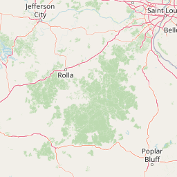
Map view of Mingo Wilderness

Use this park location map to pinpoint Mingo Wilderness in United States of America, understand its exact geographic position, and read its mapped placement within the surrounding landscape more clearly.

Pigeon | © OpenStreetMap contributors

Location context for Mingo Wilderness

Missouri
Park atlas

Compare regional geography, wildlife refuges, and connected lowland habitats

Explore Parks Near Mingo Wilderness And Surrounding Protected Landscapes

Browse other parks near Mingo Wilderness to discover additional bottomland forests, wetlands, and protected natural areas across the surrounding region. Comparing adjacent conservation lands provides deeper insight into regional park geography and Mississippi Alluvial Plain ecosystems.
National parkMissouri
About 6.3 km away#1 closest

Northwest

Mark Twain National Forest: Geography and Protected Area Atlas of Southern Missouri

Mapping the karst terrain and ancient ridges of the Ozark Highlands

Mark Twain National Forest represents a sprawling conservation area within the Missouri Ozark Highlands. Its geography is defined by volcanic mountain remnants, rocky glades, and significant river corridors like the Eleven Point National Scenic River. This record provides insight into the forest's complex mapped boundaries, seven designated wilderness areas, and the distinctive karst geology that characterizes this unique American landscape.

Area
6,037.3 km²
Established
1939
Relief
Upland
Climate
Temperate
Wildlife reserveMissouri
About 52 km away#2 closest

North

Rockpile Mountain Wilderness: Mapping the Rugged Ridge Landscapes of the Southeastern Ozarks

A federally protected wilderness within Missouri's Mark Twain National Forest

Explore the distinct geography of Rockpile Mountain Wilderness, where a steep granite ridge runs from Little Grass Mountain toward the national forest boundary. This protected area features unique cultural history in the form of an Indigenous stone cairn and showcases the eroded, rocky character of the eastern Ozark highlands. Use this resource to understand the boundary and terrain of this significant wilderness tract.

Area
17.15 km²
Established
1980
IUCN
Ib
Relief
Mountain
Watercolor painting of a wide, rolling landscape featuring layered sandstone bluffs and green forested hills against a light background.
Protected landscapeIllinois
About 74 km away#3 closest

Northeast

Shawnee National Forest: Exploring the Protected Landscapes of the Illinois Shawnee Hills

Mapped sandstone formations and glacial terrain in southern Illinois

Spanning nearly 289,000 hectares, Shawnee National Forest is the largest body of public land in Illinois. The area is defined by its dramatic sandstone bluffs, deep canyons, and seven designated wilderness areas that provide a rare rugged topography within the American Midwest. Explore the complex geography of this forest, from its glacial-sculpted river watersheds to its diverse hardwood habitats and historic reforestation sites.

Area
2,017.83 km²
Established
1933
Relief
Upland
Climate
Temperate
A soft watercolor illustration featuring rolling green hills, a winding stream, and a forested treeline against a pale sky.
Wildlife reserveMissouri
About 84 km away#4 closest

West

Irish Wilderness: Missouri Ozark Protected Area and Karst Landscape Atlas

Federally protected wilderness in the Eleven Point River landscape

Spanning the rugged terrain of the Missouri Ozarks, Irish Wilderness is a federally protected area known for its distinct karst geography. Visitors can study the network of caves, sinkholes, and springs that define the local environment, alongside historical remnants of frontier settlement. The area serves as a primary example of wilderness preservation within the Mark Twain National Forest, balancing sensitive cave ecosystems with forested ridge landscapes.

Area
65.87 km²
Established
1984
IUCN
Ib
Relief
Upland
Wildlife reserveIllinois
About 158 km away#5 closest

Northeast

Lusk Creek Wilderness: An Atlas of Protected Sandstone Canyons and Forests in Southern Illinois

Mapping rugged wilderness terrain and forest ecological recovery.

Lusk Creek Wilderness serves as a key protected landscape in southern Illinois, featuring extensive sandstone canyon systems and dense hardwood woodland. This area offers a unique look at the geological and forested character of the Shawnee region, documented through its boundaries, elevation changes, and natural landmarks. Use this geographic entry to examine the rugged, roadless character of the state largest wilderness designation and its place within the wider regional drainage system.

Area
25.47 km²
Established
1990
IUCN
Ib
Relief
Upland
Watercolor painting of rock formations and surrounding green trees on a plain white background.
Wildlife reserveIllinois
About 172 km away#6 closest

Northeast

Garden of the Gods Wilderness: A Protected Sandstone Plateau in Southern Illinois

Explore geologic boundaries, sandstone hoodoos, and forested wilderness terrain

Garden of the Gods Wilderness represents a critical protected area within the Shawnee National Forest, notable for its unglaciated sandstone geography. This 3,318-acre wilderness offers an intimate view of ancient carboniferous rock formations, including prominent hoodoos and clifftop overlooks that provide expansive sightlines across the southern Illinois landscape.

Area
13.43 km²
Established
1990
Relief
Upland
Climate
Temperate
A watercolor painting showing a stylized landscape with rolling green hills, a band of trees, and a pale pink lake surface under a soft morning sky.
Protected landscapeUnited States of America
About 177 km away#7 closest

East

Land Between the Lakes National Recreation Area: Mapped Geography and Protected Landscapes

An inland peninsula preserved between two major river reservoirs.

Land Between the Lakes National Recreation Area occupies a distinct narrow land bridge between Kentucky Lake and Lake Barkley. This protected landscape contains a dense mix of forested ridges, stream valleys, and managed wildlife prairies. The area is integral to the lower Ohio River Valley geography, showcasing the results of long-term watershed management and large-scale ecological restoration within the United States.

Area
693.1 km²
Established
1963
Visitors
2M annual
Relief
Lowland
National parkMissouri
About 183 km away#8 closest

North

Gateway Arch National Park: National Park Geographic Atlas and Map Boundaries

Explore protected landscape context and regional setting.

Gateway Arch National Park represents a unique protected landscape within Missouri, contributing to the broader national park atlas. This entry focuses on its specific geographic identity and mapped boundaries, offering structured data for understanding its role. Discover the factual landscape context and regional importance of Gateway Arch National Park for informed geographic exploration.

Area
0.78 km²
Established
2018
IUCN
II
Visitors
1.2M annual

Common questions about visiting, size, designation, and location context for Mingo Wilderness

Mingo Wilderness FAQs for park facts, access, geography, and protected area context

Find quick answers about Mingo Wilderness, including protected-area facts, park geography, trail and visitor context, and how the park fits into its surrounding country and regional landscape.
MoriAtlas Explorer

Continue Your Protected Areas Search Across the Global Atlas

Deepen your exploration by continuing the structured search for national parks and protected areas worldwide. Utilize the comprehensive filtering capabilities to compare different conservation landscapes and refine your understanding of global park geography. Discover more about the distribution and characteristics of protected natural areas.

Global natural geography