Mori Atlas logo
Wildlife reserveMission Mountains Wilderness

A rugged spine of the Mission Range featuring glaciated cirques and compressed ecological zones

Mission Mountains Wilderness: Geographic Profile and Protected Alpine Landscapes in Montana

Mission Mountains Wilderness serves as a dramatic and wall like mountain chain within the northern Rocky Mountains of Montana. This protected wilderness area rises sharply from forested lowlands into high elevation alpine tundra, creating a distinctively steep sequence of subalpine forest and glaciated basins. The geography provides an intact sanctuary for diverse wildlife and features a network of high mountain lakes, functioning as a vital federal wilderness partner in a larger cross jurisdiction conservation landscape.

alpine wildernessmontana mountainsrocky mountain frontwilderness areaflathead national forestglacial lakes

Mission Mountains Wilderness

Wildlife reserve

Park overview

Structured park overview, official facts, and landscape profile for Mission Mountains Wilderness

Mission Mountains Wilderness park facts, protected area profile, and essential visitor context

Review the core facts for Mission Mountains Wilderness, including designation, size, terrain, visitor scale, habitats, and operating context in one park-focused overview.

About Mission Mountains Wilderness

The Mission Mountains Wilderness is one of the most topographically striking wilderness areas in the northern Rocky Mountains. It occupies a central section of the Mission Range, a comparatively narrow but extremely steep mountain chain that runs roughly north-south through Lake and Missoula counties in northwestern Montana. Unlike more sprawling mountain ranges, the Missions rise as a near-continuous wall from the Flathead Valley and surrounding lowlands, producing dramatic elevation gains over very short horizontal distances.

Within the wilderness, elevations span from forested valleys and meadows at the base of the range up to high ridges, exposed alpine tundra, and glacially carved basins near the crest. This compressed elevation profile creates a layered sequence of ecosystems: dense coniferous forest, subalpine fir and Engelmann spruce bands, open parklands, and ultimately bare rock, snowfields, and alpine vegetation on the highest summits. The area's many cirque lakes, including easily recognizable features such as Ducharme Lake, are among its most photographed and frequently visited scenic elements.

The wilderness sits within the Swan Lake Ranger District of the Flathead National Forest and is managed according to the standards laid out by the 1964 Wilderness Act. Motorized and mechanized use, including bicycles, is prohibited; there are no internal roads or permanent structures, and logging and mining are not allowed. Hiking, camping, fishing with appropriate permits, and seasonal hunting provide the primary means of engaging with the landscape.

Access to the area is overwhelmingly trail-based. Montana Highway 83 and associated forest roads to the east provide the principal gateway, while a set of western approaches connect with the adjoining Mission Mountains Tribal Wilderness, managed by the Confederated Salish and Kootenai Tribes. Together, the federal and tribal wilderness units protect an unusually large and ecologically intact block of the Mission Range, helping to safeguard habitat for species such as grizzly bears, elk, mountain goats, and a wide variety of birds and smaller mammals typical of the northern Rockies.

Quick facts and research context for Mission Mountains Wilderness

The Mission Mountains Wilderness covers roughly 73,877 acres across Missoula and Lake counties in Montana, within the Flathead National Forest and its Swan Lake Ranger District. It was designated by an act of Congress in 1975 and is administered by the U.S. Forest Service as an IUCN Category Ib wilderness area.

The nearest major city is Missoula, and the wilderness lies between roughly 80 miles north of Missoula and about 65 miles southeast of Kalispell. Primary access comes from Montana Highway 83 and adjacent logging roads, with several additional trail approaches arriving from the adjoining Mission Mountains Tribal Wilderness to the west.

Protection and recognition

Terrestrial protected area classification and official recognition history

Mission Mountains Wilderness Protection Status and Recognition Data

Mission Mountains Wilderness maintains a documented terrestrial protection scope within the regional conservation network. Structured atlas records track official designation status and international recognition metrics for the protected landscape.

Protection details

Protection scope
Terrestrial
Transboundary protection
No
Park context

Deeper park guide and search-rich context for Mission Mountains Wilderness

Mission Mountains Wilderness history, landscape, wildlife, and travel context

Explore Mission Mountains Wilderness through its history, landscape character, ecosystems, wildlife, conservation priorities, cultural context, and seasonal travel timing in a structured park guide built for atlas discovery and search intent.

Why Mission Mountains Wilderness stands out

The Mission Mountains Wilderness is best known for the sheer, dramatic spine of the Mission Range itself, a relatively narrow and exceptionally steep mountain chain that appears to rise directly out of the surrounding valleys. Its elevations climb rapidly from forested lowlands into rugged alpine terrain, producing a tight ecological gradient that is unusually compressed for the northern Rockies. The wilderness is also recognized for its network of high mountain lakes, glacially carved cirques, and the unbroken quality of its wildlands. Because it sits directly next to the Mission Mountains Tribal Wilderness, it forms part of a larger, jointly managed landscape of tribal and federal protection that is unusual in the lower 48 states and a defining feature of the area's conservation identity.
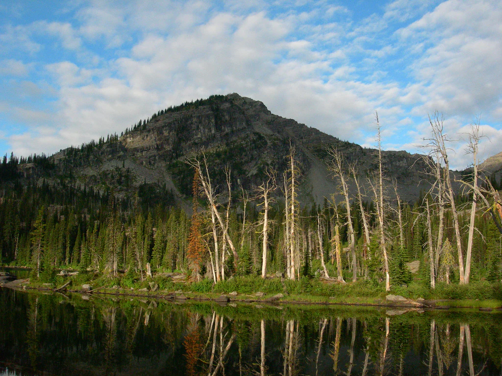
A calm mountain lake reflects the surrounding evergreen forest and the steep, rocky slopes of a mountain peak under a partly cloudy sky.
Ducharme Lake nestled at the base of the rugged Mission Mountains.

Mission Mountains Wilderness history and protected-area timeline

The Mission Mountains Wilderness was formally designated by an act of the U.S. Congress in 1975, placing the area under the protection framework established eleven years earlier by the 1964 Wilderness Act. Its designation reflected a broader national effort during the 1970s to preserve representative examples of America's remaining wild landscapes from road-building, logging, mining, and other forms of development.

Even before its federal designation, the Mission Range held deep significance for the Confederated Salish and Kootenai Tribes, whose traditional homeland includes these mountains. That cultural and ecological importance contributed to the eventual creation of a separate, adjacent Mission Mountains Tribal Wilderness on the western side of the range, matching and complementing the federal wilderness in scale and intent.

Since 1975, the area has been administered by the U.S. Forest Service within the Swan Lake Ranger District of the Flathead National Forest. Management has consistently emphasized non-motorized recreation, ecological preservation, and the maintenance of wilderness character, with the wilderness continuing to function as one of Montana's key high-country preserves for hiking, hunting, fishing, and wildlife habitat.

Mission Mountains Wilderness landscape and geographic character

The defining landscape feature of the Mission Mountains Wilderness is the Mission Range itself, a comparatively narrow but exceptionally rugged mountain chain that rises abruptly from the surrounding lowlands. The eastern flank, which forms much of the wilderness, descends toward the Swan Valley and the broader Flathead basin, while the steeper and shorter western slopes fall toward the Flathead Valley and adjoining tribal lands.

The terrain is characterized by sharp ridgelines, deeply incised valleys, and a striking absence of gentle transitions. Lower slopes are cloaked in dense coniferous forest, giving way upslope to subalpine stands of fir and spruce, open glacial meadows, and eventually the exposed rock, talus, and sparse alpine vegetation of the high country. Numerous small glaciers once shaped these mountains, leaving behind classic U-shaped valleys, cirques, and a network of high mountain lakes such as Ducharme Lake that have become signature features of the range.

Because the range runs nearly perpendicular to prevailing weather patterns, its slopes often receive heavy snowfall, sustaining snowfields well into the summer in some years and reinforcing the area's distinctive seasonal contrasts. The combination of elevation, aspect, and glacial history makes the Missions visually dramatic in a way that is unusual even within the broader context of the northern Rocky Mountains.

Mission Mountains Wilderness ecosystems, habitats, and plant life

Ecologically, the Mission Mountains Wilderness represents an unusually compressed and well-protected example of northern Rocky Mountain ecosystems. Within a relatively short vertical distance, the wilderness supports a layered sequence of vegetation zones, from dry and mesic coniferous forests at its base through moist subalpine forests, alpine meadows, and finally a fragile tundra-like zone near the highest summits.

Forests in the lower and middle elevations are dominated by species such as Douglas fir, lodgepole pine, and Engelmann spruce, depending on slope, aspect, and moisture. Above treeline, vegetation thins into hardy alpine grasses, sedges, and cushion plants adapted to short growing seasons and harsh exposure. The many cirque basins and lakes scattered across the range contribute additional wetland and aquatic habitat, supporting distinctive plant communities and serving as important breeding and feeding areas for wildlife.

This ecological compression, together with the wilderness's relatively intact condition and long-standing protection, gives the mission Mountains Wilderness considerable significance as a refuge for native northern Rockies biodiversity and as a benchmark for understanding how elevation, moisture, and aspect interact to shape mountain ecosystems in the region.

Mission Mountains Wilderness wildlife and species highlights

The Mission Mountains Wilderness supports a rich and ecologically important assemblage of wildlife typical of the northern Rocky Mountains. Its mix of dense forest, open meadows, alpine basins, and rugged rocky terrain provides habitat for several species that depend heavily on large, undeveloped landscapes.

Grizzly bears and black bears roam the wilderness, taking advantage of its berry-producing slopes, alpine meadows, and remote valleys. Elk use the area's meadows and forest edges, particularly during summer and the fall rut, while mule deer and white-tailed deer occupy lower-elevation habitats. The steep, rocky upper terrain is especially important for mountain goats, which favor the cliff bands, talus, and high ridges that the Mission Range offers in abundance. Moose are also present in suitable riparian areas.

Predators include mountain lions and coyotes, while smaller mammals such as marmots, pikas, red squirrels, and various bat species occupy the range of habitats from valley bottoms to alpine zones. The wilderness's many lakes, streams, and meadows attract diverse birdlife, including raptors such as golden eagles, as well as waterfowl, grouse, and a wide variety of songbirds. Because of the area's size, undeveloped character, and linkage with surrounding wildlands, the Mission Mountains Wilderness plays a meaningful role in maintaining viable populations of wide-ranging species across the broader Flathead region.

Mission Mountains Wilderness conservation status and protection priorities

From a conservation perspective, the Mission Mountains Wilderness is significant as a large, roadless block of federally protected wilderness that helps safeguard the ecological integrity of the northern Rocky Mountains. Its designation in 1975 ensured that an exceptional section of the Mission Range would remain free from road-building, logging, mining, and motorized recreation, preserving ecological processes largely undisturbed by modern development.

The wilderness is most notable for its close partnership with the adjoining Mission Mountains Tribal Wilderness, managed by the Confederated Salish and Kootenai Tribes. Together, the federal and tribal wilderness units protect virtually the entire Mission Range as a single, largely unbroken conservation landscape, an arrangement that is unusual in the contiguous United States and that greatly enhances habitat connectivity for large mammals such as grizzly bears, elk, and mountain goats.

On a wider scale, the Mission Mountains Wilderness contributes to the ecological network of the Flathead region, buffered by surrounding national forest lands and connected ecologically to the Bob Marshall Wilderness complex to the east and south. This positioning gives the area added importance for watershed protection, climate refugia, and the long-term persistence of species that require extensive, low-disturbance habitat.

Mission Mountains Wilderness cultural meaning and human context

The Mission Mountains hold deep cultural significance for the Confederated Salish and Kootenai Tribes, whose ancestral and contemporary homeland includes this range. The mountains are woven into tribal history, traditional use, and present-day stewardship, and they are reflected in place names, stories, and ongoing cultural practice across the Flathead reservation and surrounding communities.

The decision by the tribes to establish their own Mission Mountains Tribal Wilderness on the western side of the range was a landmark act of indigenous-led conservation, expanding protection beyond the federal designation and creating a jointly protected landscape that honors both tribal sovereignty and ecological preservation. Visitors to the area are often reminded that the Mission Range is not only a scenic destination but also a culturally meaningful landscape with an active indigenous presence and a continuing tribal role in its stewardship.

Top sights and standout views in Mission Mountains Wilderness

The Mission Mountains Wilderness stands out for the unusual combination of dramatic topography, ecological richness, and strong conservation partnerships. Its defining highlight is the steep, wall-like profile of the Mission Range, which appears to rise in a single sweeping line from the surrounding valleys and offers some of the most visually arresting mountain scenery in Montana.

Equally important are the wilderness's many high mountain lakes and glacial basins, its tightly compressed sequence of forest, subalpine, and alpine habitats, and its role as the federal counterpart to the Mission Mountains Tribal Wilderness. Together, these qualities make the area a focal point for non-motorized recreation, wildlife observation, and landscape-scale conservation in the northern Rockies.

Best time to visit Mission Mountains Wilderness

Summer is the most accessible and popular time to experience the Mission Mountains Wilderness, typically from late June through early September, when the majority of the high country is free of snow, trails are generally walkable, and alpine meadows and lakes are at their most visible. Long daylight hours and stable weather make this period especially suitable for backpacking, lake-hopping trips, and peak-bagging adventures.

Late spring and early fall offer quieter conditions and can showcase vivid wildflower displays or early autumn color in the subalpine forests, but these shoulder seasons also bring unpredictable weather, lingering snow at higher elevations, and reduced access to some of the more rugged routes. Winter conditions are severe and transform the area into a demanding snow-covered environment suitable only for experienced backcountry travelers with appropriate skills and equipment.
Monthly climate preview

Long-term representative point measurements tracking monthly temperature and precipitation rhythms

Mission Mountains Wilderness Climate Normals and Annual Weather Patterns

Historical data records recorded average monthly temperatures ranging from sub-zero winter lows to warmer summer peaks alongside consistent daily precipitation. Reviewing full twelve-month records provides deeper insight into measured meteorological variations across the protected landscape.
Annual mean3 °C
-8 °C17 °C
Jan-8°
Feb-7°
Mar-3°
Apr
May
Jun12°
Jul17°
Aug17°
Sep11°
Oct
Nov-3°
Dec-8°
Warmest month
July

16.7 °C

Coolest month
December

-8.1 °C

Wettest month
January

3.4 mm/day

Driest month
July

1.2 mm/day

Park location guide

Geography guide, regional context, and park location map for Mission Mountains Wilderness

Mission Mountains Wilderness park geography, regions, and map view in United States of America

Understand where Mission Mountains Wilderness sits in United States of America through a broader geographic reading of the surrounding landscape, nearby location context, and its mapped position within the national park landscape.

How Mission Mountains Wilderness fits into United States of America

The United States of America is a federal presidential republic and one of the world's largest countries by area and population. It consists of 50 states across a vast territory spanning multiple time zones, with its capital in Washington, D.C. and largest city in New York City. The nation has a diverse economy, influential political system, and significant cultural and military presence globally.

Wider geography shaping Mission Mountains Wilderness in United States of America

The United States occupies a vast territory in North America, bordered by Canada to the north and Mexico to the south. The 48 contiguous states stretch from the Atlantic to the Pacific Ocean, while Alaska occupies the northwestern region and Hawaii is an archipelago in the Pacific. The country encompasses diverse terrain including the Rocky Mountains, Appalachian Mountains, Great Plains, and extensive river systems.

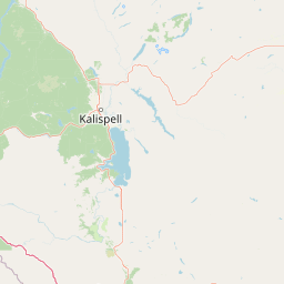
Map view of Mission Mountains Wilderness

Use this park location map to pinpoint Mission Mountains Wilderness in United States of America, understand its exact geographic position, and read its mapped placement within the surrounding landscape more clearly.

Pigeon | © OpenStreetMap contributors

Location context for Mission Mountains Wilderness

Montana
Recorded earthquake history

Review the Historical Earthquake Catalogue for Mission Mountains Wilderness

Explore the record of historical seismic activity associated with the Mission Mountains Wilderness. Review event metrics, including magnitude and epicentre distance, within this curated collection on MoriAtlas. Access clear, source-linked data to understand the regional seismic history of this protected Montana wilderness area.

Mission Mountains Wilderness Earthquake History

Catalogued events

82 events

Strongest magnitude

Magnitude 4.8

Most recent event

Aug 28, 2026

This history includes earthquakes recorded inside the park or within 50 km of its borders

Visual reference for high mountain lakes, steep terrain, and protected northern Rockies habitats

Mission Mountains Wilderness Photos and Scenery: Exploring Rugged Alpine Landscapes

Examine curated photography of Mission Mountains Wilderness to analyze the sheer vertical relief, glaciated cirques, and dense forest ecosystems defining the range. Visualizing these protected landscapes clarifies the dramatic topographical gradients and remote wilderness character preserved across Montana.

A calm mountain lake reflects the surrounding evergreen forest and the steep, rocky slopes of a mountain peak under a partly cloudy sky.

Park atlas

Compare adjacent mountain ranges, glacial lakes, and connected regional wildlands.

Explore Parks Near Mission Mountains Wilderness and Surrounding Protected Areas

Browse other protected areas and rugged mountain reserves situated across the surrounding northern Rockies region. Expanding the geographic comparison reveals how adjacent ecosystems and wildland blocks share similar glacial terrain and conservation priorities.
Protected areaMontana
Park boundaries overlap#1 closest

Southwest

Lolo National Forest: An Atlas of Protected Lands and Mountainous Terrain in Montana

Ecological transition zone of the northern Rocky Mountains

This protected area covers two million acres of diverse northern Rocky Mountain geography. Known for its massive western red cedars and transitional ecology, the forest features a complex network of ridgelines, glacial lake basins, and river corridors that serve as vital habitat across the Montana landscape.

Area
8,894.85 km²
Established
1906
Relief
Mountain
Climate
Temperate
Wildlife reserveMontana
19 km away#2 closest

South

Rattlesnake Wilderness: Exploring the Protected Landscapes and Geography of Montana

Rugged alpine terrain and roadless mountain wilderness in the Northern Rockies.

Located in the Lolo National Forest of western Montana, Rattlesnake Wilderness protects an essential network of forested slopes, alpine ridges, and drainage headwaters. This roadless wildlife reserve provides an ecologically intact landscape that serves as a core component of the northern Rockies wilderness system, offering a clear view into the rugged relief of the Rattlesnake Mountains and their significant influence on local watersheds.

Area
133.45 km²
Established
1980
IUCN
Ib
Relief
Mountain
A watercolor painting of a serene landscape with coniferous trees, rolling hills, and soft-toned, layered mountains.
Protected landscapeMontana
About 36 km away#3 closest

South

Rattlesnake National Recreation Area: Geography and Protected Landscape Analysis

A mapped Northern Rockies gateway in western Montana

The recreation area encompasses 28,000 acres of forested mountain terrain, montane wetlands, and creek-carved valleys located just north of Missoula. This protected landscape is defined by its diverse trail network and significant ecological systems, including the rare Sphagnum bogs of Shoo Fly Meadows. The area provides essential habitat for grizzly bears, elk, and bull trout while framing a transition zone into the remote backcountry of the surrounding national forest.

Area
110 km²
Established
1980
Relief
Mountain
Scope
Terrestrial
A watercolor painting depicting a soft, stylized mountain range and a river winding through a valley.
Protected landscapeMontana
50 km away#4 closest

East

Helena-Lewis and Clark National Forest: Geographic Overview and Protected Area Map

Montana wilderness spanning the Continental Divide

Spanning from the rolling eastern plains to the crest of the Northern Rockies, Helena-Lewis and Clark National Forest serves as a massive protected landscape in central Montana. This forest system protects eight unique mountain ranges and critical wilderness corridors, offering a comprehensive look at the ecological transition zones of the American Mountain West.

Area
11,000 km²
Established
1897
Relief
Mountain
Climate
Temperate
National parkMontana
65 km away#5 closest

North

Glacier National Park: A Montana National Park with Distinct Protected Landscape Geography

Explore its mapped boundaries and regional natural terrain.

Glacier National Park represents a significant national park entity within Montana, providing a unique lens for understanding protected landscapes and regional geography. As a key component of the US protected areas network, it offers valuable insights into mapped park boundaries and the surrounding natural terrain. This page serves as a gateway to exploring the specific geographic context and landscape identity of Glacier National Park.

Area
4,100.77 km²
Established
1910
IUCN
II
Visitors
2.9M annual
A soft watercolor painting depicting rolling mountains in the background with a line of forest in the midground and open terrain in the foreground.
Protected landscapeMontana
72 km away#6 closest

Northwest

Kootenai National Forest: Geography and Protected Land Map for Northwestern Montana

Northern Rockies mountain ranges and watershed analysis.

Spanning over two million acres, Kootenai National Forest represents a critical protected landscape in the Northern Rockies. This atlas entry details the interplay between the Cabinet Mountains, regional river systems like the Kootenai and Clark Fork, and the dense conifer forests that define this uniquely wet corner of Montana.

Area
8,900 km²
Established
1907
Relief
Mountain
Climate
Temperate
National parkAlberta
144 km away#7 closest

North

Waterton Lakes National Park: Alberta's Protected Landscape and Geographic Atlas

Explore mapped boundaries and regional terrain context.

Waterton Lakes National Park represents a vital protected area situated within the province of Alberta. This atlas view focuses on its mapped boundaries and the characteristic natural terrain, providing essential geographic context for understanding its significance. Discover its role as a national park and its placement within the regional geography of Western Canada, ideal for users seeking structured data on protected lands and landscape features.

Area
505 km²
Established
1895
IUCN
II
Visitors
475.8K annual
Watercolor painting of a light-colored landscape featuring a river meandering through green trees and soft hills against a hazy background.
Wildlife reserveMontana
147 km away#8 closest

Southeast

Gates of the Mountains Wilderness: Montana Protected Landscape and Geographic Overview

Explore Missouri River canyon boundaries and local terrain

Gain insight into the geological drama of Gates of the Mountains Wilderness, a protected reserve in Montana. This atlas entry focuses on the limestone canyon walls and historic river corridors that define the regional geography, offering a structured look at its protected boundaries and terrain.

Area
115.59 km²
Established
1964
IUCN
Ib
Relief
Mountain

Common questions about visiting, size, designation, and location context for Mission Mountains Wilderness

Mission Mountains Wilderness FAQs for park facts, access, geography, and protected area context

Find quick answers about Mission Mountains Wilderness, including protected-area facts, park geography, trail and visitor context, and how the park fits into its surrounding country and regional landscape.
MoriAtlas Explorer

Continue Your Protected Areas Search Across the Global Atlas

Deepen your exploration by continuing the structured search for national parks and protected areas worldwide. Utilize the comprehensive filtering capabilities to compare different conservation landscapes and refine your understanding of global park geography. Discover more about the distribution and characteristics of protected natural areas.

Global natural geography