Mori Atlas logo
Marine protected areaMoana Uta (Wet Jacket Arm) Marine Reserve

Tracing the deep-water fiord boundaries, ecological stratification, and unique marine habitats of this southern reserve

Moana Uta (Wet Jacket Arm) Marine Reserve: Protected Marine Landscapes in Fiordland, New Zealand

Moana Uta (Wet Jacket Arm) Marine Reserve represents a vital segment of the Fiordland coastline, encompassing the full length of a narrow, steep-walled fiord. This protected area is defined by a unique vertical water stratification, where a freshwater cap shields a productive marine mid-layer rich in black coral, reef fish, and sponges. The geography reveals a dense collection of microhabitats ranging from rocky reefs and shallow kelp forests to deep, tannin-stained basins that descend hundreds of metres.

marine reserveFiordlandfiordblack coralrocky reefdeep basin

Moana Uta (Wet Jacket Arm) Marine Reserve

Marine protected area

Park overview

Structured park overview, official facts, and landscape profile for Moana Uta (Wet Jacket Arm) Marine Reserve

Moana Uta (Wet Jacket Arm) Marine Reserve park facts, protected area profile, and essential visitor context

Review the core facts for Moana Uta (Wet Jacket Arm) Marine Reserve, including designation, size, terrain, visitor scale, habitats, and operating context in one park-focused overview.

About Moana Uta (Wet Jacket Arm) Marine Reserve

Moana Uta (Wet Jacket Arm) Marine Reserve protects the full length of Wet Jacket Arm, one of the longer and more sheltered fiords carved into the southwestern corner of New Zealand's South Island. Located in the remote Fiordland region, the reserve is administered by the Department of Conservation and was formally established on 21 April 2005 as part of the Fiordland Marine Guardians' broader effort to safeguard the marine environment of southwestern Fiordland. It covers approximately 2,007 hectares between Entry Island at the entrance and the head of the sound.

What makes the reserve significant from an ecological perspective is not its size alone but the unusual vertical structure of the water column above its seabed. In Fiordland's fiords, intense rainfall on the surrounding mountains funnels freshwater down through the steep catchments and across the surface, forming a permanent layer above the ocean water. Beneath this cap, the seawater remains calm, clear, and considerably warmer than the open ocean, supporting a rich community of sponges, soft corals, and fish that thrives in conditions resembling a sheltered marine haven. A third layer, darkened by tannins leached from the surrounding temperate forest, descends to extraordinary depths of up to around 400 metres and hosts little of the visible marine life associated with the upper layers.

The Wet Jacket Arm itself is a textbook Fiordland fiord: long, narrow, deeply incised, and visually dramatic, with steep forested rock walls plunging toward a deep central basin. Near islands and headlands such as Oke Island, stronger tidal flow sweeps the rock walls, encouraging communities of suspension feeders such as lampshells (brachiopods). The quieter central basin, shielded from open ocean swell and shaded by surrounding peaks, has allowed black coral colonies to establish at higher densities than in any other part of Fiordland. Rock walls, broken reef, sheltered basins, and small estuaries all coexist within the reserve's boundaries, providing a remarkable, compact example of fiord marine ecology.

The reserve is closely tied to the wider Fiordland conservation framework, including partnerships among the Ministry for the Environment, the Ministry of Primary Industries, and mana whenua. It is also a significant cultural site: under the reserve's regulations, Ngāi Tahu are permitted to collect pounamu (greenstone) and certain marine mammal remains, provided these activities follow traditional protocols and authorisation.

Quick facts and research context for Moana Uta (Wet Jacket Arm) Marine Reserve

Moana Uta (Wet Jacket Arm) Marine Reserve lies in Fiordland on the southwestern coast of New Zealand's South Island, covering the full length of Wet Jacket Arm from Entry Island to the head of the fiord. The protected area spans 2,007 hectares (4,960 acres) and was officially established on 21 April 2005, becoming one of several marine reserves created from a conservation strategy developed by the Fiordland Marine Guardians.

The reserve is administered by the New Zealand Department of Conservation and forms part of Fiordland's broader system of marine protected areas. Its marine environment is shaped by the surrounding mountains, whose heavy rainfall creates a permanent freshwater lid over the fiord's saltwater column and strongly influences the underwater habitats found within the reserve.

Protection and recognition

Examine the documented marine protection scope and formal designation framework.

Moana Uta (Wet Jacket Arm) Marine Reserve Protection Status and Designation Facts

Marine protection status and formal designation records outline the regulatory boundaries established for Moana Uta (Wet Jacket Arm) Marine Reserve. Detailed administrative facts provide clear reference metrics for conservation geography without external program claims.

Protection details

Protection scope
Marine
Transboundary protection
No
Park context

Deeper park guide and search-rich context for Moana Uta (Wet Jacket Arm) Marine Reserve

Moana Uta (Wet Jacket Arm) Marine Reserve history, landscape, wildlife, and travel context

Explore Moana Uta (Wet Jacket Arm) Marine Reserve through its history, landscape character, ecosystems, wildlife, conservation priorities, cultural context, and seasonal travel timing in a structured park guide built for atlas discovery and search intent.

Why Moana Uta (Wet Jacket Arm) Marine Reserve stands out

The reserve is best known for hosting the highest density of black coral in Fiordland, a striking result of the fiord's deeply shaded, sheltered main basin and its unusual layered water column. It is also notable for its exceptional physical stratification: a thin freshwater layer floating above a warm, clear marine mid-layer rich in sponges, corals, and reef fish, and a deep, dark, tannin-stained lower layer that descends to roughly 400 metres. The fiord's combination of steep rock walls, broken rocky reef, deep basin, and estuarine inlets, paired with strong tidal flows around islands such as Oke Island, creates a diversity of microhabitats unusually compressed into a single long inlet.
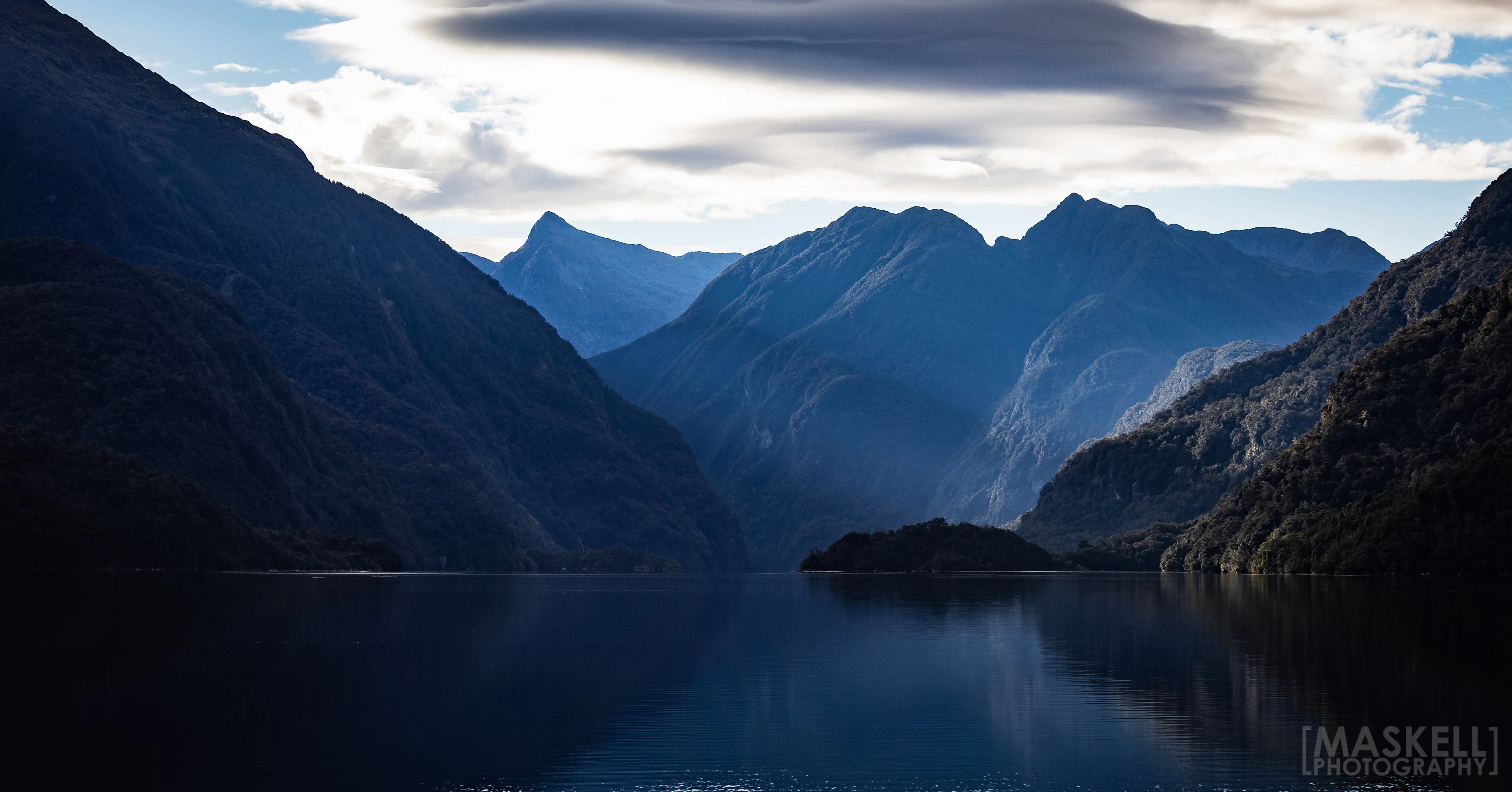
A wide, landscape view of dark, steep mountain slopes rising from a calm, reflective body of water under a dramatic, clouded sky.
A view of the still waters and steep mountains of Wet Jacket Arm in Fiordland, New Zealand.

Moana Uta (Wet Jacket Arm) Marine Reserve history and protected-area timeline

The fiord itself carries a long human story. European exploration of Wet Jacket Arm is generally traced to 1773, when the crew of HMS Resolution under Captain James Cook charted and named the inlet. The name 'Wet Jacket Arm' comes from an incident in which crewmen rowed the length of the fiord in calm conditions, only to be caught by a sudden storm that left them without a fire for warmth or cooking, and thus spent the night in damp clothes. The name has stuck ever since.

In the early twentieth century, the wider Fiordland region became the unlikely home of introduced moose. Moose brought from Canada were released in Fiordland in 1910 and photographed intermittently over subsequent decades. A photograph purportedly taken in Wet Jacket Arm in 1953 was later shown to have been captured in a different location, illustrating how the remote and visually uniform character of Fiordland's fiords has historically confused even well-intentioned observers. 'Moose hunting' trips continued into the later twentieth century, although the animals have since disappeared from the landscape.

The marine reserve itself was the product of a more recent, deliberate conservation effort. In 2002, the Fiordland Marine Guardians launched a strategy to protect the area's marine environment, which they presented to Minister for the Environment Marian Hobbs and Minister of Fisheries Pete Hodgson in 2003. Following this advocacy, Wet Jacket Arm was officially designated as a marine reserve on 21 April 2005, giving statutory protection to its waters from Entry Island to the head of the sound.

Since its establishment, the reserve has continued to benefit from inter-agency management. The Department of Conservation administers the site, while the Ministry of Primary Industries, the Fiordland Marine Guardians, and other agencies collaborate to monitor the marine environment and to prevent the spread of invasive seaweed. In 2021, the New Zealand Air Force conducted aerial surveillance flights over the reserve and adjacent waters to detect illegal commercial fishing activity.

Moana Uta (Wet Jacket Arm) Marine Reserve landscape and geographic character

Wet Jacket Arm is a classic Fiordland fiord: a long, narrow, steep-walled inlet carved deep into the mountains of the South Island's southwestern coast. The reserve covers the full length of this inlet, from Entry Island near its mouth to the far head of the sound. Towering forested slopes rise on either side of the water, and the cliffs often drop abruptly toward the surface without the gradual shelving that characterises most coastlines.

Within the reserve, the underwater landscape is equally diverse. The shoreline includes extensive rock walls and broken rocky reef, while the central basin plunges to considerable depth and is fully shielded from ocean swell. Smaller estuarine inlets branch off the main sound, and islands such as Oke Island punctuate the waterway, each with their own distinctive tidal conditions. These varied substrates and exposures create an unusually compact range of marine microhabitats within a single fiord system.

The freshwater cap on the surface is one of the most distinctive physical features of the reserve. In some places this layer is merely a thin film of a few centimetres; in deeper basins influenced by higher rainfall it can extend to around ten metres below the surface. Beneath this lid, the marine water is calm and clear, a striking contrast to the rough, swell-driven coastal environment outside the fiord.

Moana Uta (Wet Jacket Arm) Marine Reserve ecosystems, habitats, and plant life

The reserve's ecosystems are shaped as much by water column structure as by the surrounding land. The interplay between freshwater runoff from the heavily forested catchments, marine water entering from the outer coast, and tannins leached from the temperate rainforest produce a stratified environment unlike almost anywhere else in New Zealand.

In the upper marine layer, where light penetrates and the water is warm and stable, extensive communities of sponges and corals thrive alongside reef fish. Rock walls near points of stronger tidal flow, such as around Oke Island, support suspension feeders such as lampshells (brachiopods), which depend on moving water to deliver their food. Below the tidal zone, some rocky reefs host dense kelp beds and sea urchins (kina).

The deep central basin is dominated by black coral colonies, which establish themselves in low-light, low-disturbance conditions. Brittle stars live among the branches of these coral colonies, taking advantage of the structure they provide. Deeper still, tannin-stained water limits the ability of most marine life to persist, creating a quiet and impoverished but visually dramatic lower layer that descends hundreds of metres toward the seabed.

Moana Uta (Wet Jacket Arm) Marine Reserve wildlife and species highlights

Moana Uta supports a mix of marine and coastal wildlife drawn from the broader Fiordland ecosystem. Bottlenose dolphins (aihe) are known to use the fiord's sheltered waters, and New Zealand fur seals (kekono) haul out on the surrounding coast and islands, taking advantage of the rocky terrain. The reserve also provides habitat for two penguin species: the Fiordland crested penguin (tawaki), a species strongly associated with the Fiordland coast, and the smaller little blue penguin (kororā).

Underwater, the most celebrated wildlife feature is the dense population of black coral in the deep basin, where their branching structures host brittle stars and other invertebrates. Brachiopods, or lampshells, are locally common along exposed rock walls and represent one of the more unusual and ancient lineages of marine life still present in Fiordland. Together, these species give the reserve a distinctive wildlife profile that reflects both the unusual water conditions and the undisturbed nature of the fiord environment.

Moana Uta (Wet Jacket Arm) Marine Reserve conservation status and protection priorities

The reserve's principal conservation value lies in its protection of one of Fiordland's most ecologically distinctive fiords. By prohibiting fishing, the taking or moving of marine life, and anchoring in many areas, the reserve preserves an environment where fragile communities such as black coral forests, sponge gardens, and lampshell colonies can persist with minimal direct human interference.

Its placement within the broader Fiordland Marine Guardians' conservation framework reflects a coordinated view that the region's fiords are exceptional and require targeted protection. The reserve also plays a role in controlling invasive marine threats: agencies including the Department of Conservation, the Ministry of Primary Industries, and the Fiordland Marine Guardians work together to monitor and prevent the spread of invasive seaweed in and around the reserve.

Enforcement is an active element of management. Aerial patrols by the New Zealand Air Force in 2021, for example, were used to detect illegal commercial fishing activity in the reserve and nearby waters. The reserve's regulatory regime also recognises the cultural responsibilities of Ngāi Tahu, allowing authorised collection of pounamu and certain marine mammal remains in ways that respect customary protocols while preserving the broader ecological protections of the site.

Moana Uta (Wet Jacket Arm) Marine Reserve cultural meaning and human context

The reserve's dual name reflects the shared cultural landscape of Fiordland. 'Moana Uta' is the name used by mana whenua, particularly Ngāi Tahu, recognising the long-standing customary relationship of Māori with these waters and their resources. The English name 'Wet Jacket Arm' originates from Captain James Cook's 1773 voyage aboard HMS Resolution and reflects the European exploration history of the fiord.

The reserve's regulations accommodate Ngāi Tahu cultural practices alongside ecological protection. Authorised customary collection of pounamu (greenstone) is permitted, as is the collection, under appropriate protocols, of deceased marine mammals and certain of their remains. These provisions reflect recognition of the role of tangata whenua as kaitiaki, or guardians, of the marine environment and acknowledge that the fiord has long cultural as well as ecological significance.

Top sights and standout views in Moana Uta (Wet Jacket Arm) Marine Reserve

Moana Uta (Wet Jacket Arm) Marine Reserve stretches across an entire long, narrow Fiordland fiord, offering an unusually complete snapshot of how these southern inlets function. Among its most distinctive features are the highest known densities of black coral in Fiordland, thriving in a shaded, sheltered basin beneath a stable freshwater cap.

The reserve also stands out for its diverse microhabitats: tidal rock walls with lampshells and other suspension feeders, kelp beds and kina on shallow reef, steep rock walls, deep basins, and estuarine pockets. Its recognition of Ngāi Tahu customary rights, including authorised pounamu collection, adds a cultural dimension that complements its ecological protection.

Best time to visit Moana Uta (Wet Jacket Arm) Marine Reserve

Fiordland's climate is famously wet, with substantial rainfall feeding the freshwater layer that defines Wet Jacket Arm's water column. Calm, settled weather offers the best conditions for appreciating the fiord's quiet grandeur and for diving or snorkelling, when the marine visibility in the upper layers is at its clearest. Cooler months may bring stronger storms and reduced access, while the brighter summer months generally provide longer daylight hours and more favourable boating conditions.

Wildlife sightings are not strongly seasonal in this sheltered environment, though penguin and fur seal viewing tends to be easier along accessible rocky shorelines throughout the warmer months. Because the reserve is in a remote part of the South Island, visitors should expect weather to play a defining role in any trip, with the calmest conditions typically aligning with the broader New Zealand summer.
Monthly climate preview

Long-term representative temperature ranges and monthly precipitation patterns for Fiordland

Moana Uta (Wet Jacket Arm) Marine Reserve Climate Normals And Annual Weather By Month

Representative coordinates record mild summer warmth alongside cooler winter minimums paired with steady year-round precipitation averages. Detailed monthly breakdowns provide deeper insight into long-term climate behavior across the reserve terrain.
Annual mean9 °C
5 °C12 °C
Jan12°
Feb12°
Mar11°
Apr
May
Jun
Jul
Aug
Sep
Oct
Nov
Dec11°
Warmest month
February

12.2 °C

Coolest month
July

5.1 °C

Wettest month
October

8.6 mm/day

Driest month
July

6.6 mm/day

Park location guide

Geography guide, regional context, and park location map for Moana Uta (Wet Jacket Arm) Marine Reserve

Moana Uta (Wet Jacket Arm) Marine Reserve park geography, regions, and map view in New Zealand

Understand where Moana Uta (Wet Jacket Arm) Marine Reserve sits in New Zealand through a broader geographic reading of the surrounding landscape, nearby location context, and its mapped position within the national park landscape.

How Moana Uta (Wet Jacket Arm) Marine Reserve fits into New Zealand

New Zealand is an island nation in the southwestern Pacific Ocean comprising two main islands and numerous smaller islands. Located east of Australia across the Tasman Sea, it features varied topography with the Southern Alps running along the South Island and volcanic terrain on the North Island. The country was settled by Maori people between 1280 and 1350, followed by European exploration beginning in 1642, and became a Dominion in 1907 before gaining full independence in 1947.

Wider geography shaping Moana Uta (Wet Jacket Arm) Marine Reserve in New Zealand

New Zealand lies in the southwestern Pacific Ocean, east of Australia across the Tasman Sea. The country consists of two main islands, the North Island and South Island, plus over 600 smaller islands. The North Island features volcanic plateaus and hills while the South Island is dominated by the Southern Alps mountain range. The country has a long coastline and is surrounded by the Pacific Ocean.

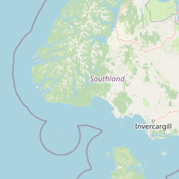
Map view of Moana Uta (Wet Jacket Arm) Marine Reserve

Use this park location map to pinpoint Moana Uta (Wet Jacket Arm) Marine Reserve in New Zealand, understand its exact geographic position, and read its mapped placement within the surrounding landscape more clearly.

Pigeon | © OpenStreetMap contributors

Location context for Moana Uta (Wet Jacket Arm) Marine Reserve

Fiordland
Recorded earthquake history

Explore the Seismic History of Moana Uta (Wet Jacket Arm) Marine Reserve

Review recorded seismic events associated with this Fiordland marine protected area. MoriAtlas provides a clear, data-driven catalogue to help researchers and visitors understand the historical seismic profile of the Moana Uta (Wet Jacket Arm) Marine Reserve region.

Moana Uta (Wet Jacket Arm) Marine Reserve Earthquake History

Catalogued events

371 events

Strongest magnitude

Magnitude 7.8

Most recent event

Jul 21, 2025

This history includes earthquakes recorded inside the park or within 50 km of its borders

Visual reference guide to steep fiord walls, layered waters, and protected marine habitats.

Moana Uta (Wet Jacket Arm) Marine Reserve Photos and Landscape Scenery

Visual documentation captures the steep forested cliffs, sheltered waters, and complex marine habitats of Moana Uta (Wet Jacket Arm) Marine Reserve. Photographic records reveal the distinctive physical stratification, rocky reefs, and unique ecological character defining this remote New Zealand fiord.

A wide, landscape view of dark, steep mountain slopes rising from a calm, reflective body of water under a dramatic, clouded sky.

Park atlas

Compare nearby marine reserves and connected wilderness habitats across the southwestern coast

Explore Protected Areas Near Moana Uta (Wet Jacket Arm) Marine Reserve and Surrounding Fiordland Landscapes

Browse other protected areas and marine reserves situated within the rugged coastal geography surrounding Moana Uta (Wet Jacket Arm) Marine Reserve. Extending geographic comparison beyond a single inlet reveals the wider regional spread of protected fiord ecosystems and coastal habitats.
National parkSouthland Region
Park boundaries overlap#1 closest

East

Fiordland National Park: A Protected Landscape of Glacier-Carved Fiords and Alpine Wilderness

Explore its vast boundaries and unique temperate rainforest.

Fiordland National Park, located in the Southland Region of New Zealand, is a testament to dramatic geological forces, featuring fifteen major fiords like Milford Sound, whose Mitre Peak rises majestically from the water. This protected national park encompasses an immense wilderness of alpine terrain, ancient beech forests, and numerous waterfalls, fueled by exceptional rainfall. Its inclusion in the Te Wāhipounamu World Heritage Area underscores its global significance for biodiversity and natural landscape preservation.

Area
12,607 km²
Established
1952
IUCN
II
Visitors
500K annual
Marine protected areaFiordland
22 km away#2 closest

Northeast

Taipari Roa (Elizabeth Island) Marine Reserve: Fiordland Marine Landscape and Atlas Map

Protected marine terrain and glacial fjord geography

Taipari Roa (Elizabeth Island) Marine Reserve is a protected marine area situated within the complex fjord network of Doubtful Sound. The reserve is characterized by steep underwater rock walls, deep kelp forests, and a unique freshwater cap that allows rare corals and glass sponges to thrive at shallow depths. This geographic overview examines the reserve's protected status and its structural role within the broader Fiordland ecosystem, highlighting the vertical aquatic terrain and surrounding islet environments.

Area
6.13 km²
Established
2005
Relief
Lowland
Climate
Temperate
Watercolor painting of a green, hilly landscape with a winding river or inlet and pale, misty mountains in the background.
Marine protected areaFiordland
35 km away#3 closest

Northeast

Kutu Parera (Gaer Arm) Marine Reserve: Fiordland Protected Marine Landscape Atlas

Mapped marine boundaries, stratified fiord ecology, and coastal terrain analysis

Explore the structured geography of Kutu Parera (Gaer Arm) Marine Reserve, a 433-hectare protected area located within the steep, mountain-flanked fjords of New Zealand. Gain insight into its complex underwater features, including vertical rock walls, estuarine basins, and stratified water columns that define this unique marine environment within the Fiordland region.

Area
4.33 km²
Established
2005
Relief
Mixed relief
Climate
Temperate
Marine protected areaFiordland
52 km away#4 closest

Northeast

Kahukura (Gold Arm) Marine Reserve: Marine Protected Area and Fiordland Geographic Atlas

Submerged rocky reefs and vertical rock wall landscapes

Located in the heart of New Zealand, Kahukura (Gold Arm) Marine Reserve provides a vital map of protected coastal terrain. Its unique environment features freshwater caps, tannin-stained deep water, and diverse marine topography ranging from sheltered basin ecosystems to vertical cliff structures. This marine area offers deep insight into the complex geology and conservation dynamics of the Fiordland region.

Area
4.64 km²
Established
2005
Relief
Mixed relief
Climate
Temperate
Marine protected areaFiordland
96 km away#5 closest

Northeast

Hawea (Clio Rocks) Marine Reserve: Protected Marine Geography in Fiordland, New Zealand

Mapping vertical rock walls and stratified fiord water ecosystems.

Hawea (Clio Rocks) Marine Reserve is an ecologically significant marine protected area situated within the deep waters of Hāwea / Bligh Sound. The reserve is defined by its dramatic vertical rock walls, tidal current channels, and the complex water stratification that sustains diverse black coral and reef communities. It offers a unique window into the geological and marine processes that have shaped the rugged coastal landscape of New Zealand's Fiordland.

Area
4.11 km²
Established
2005
IUCN
Ia
Relief
Mountain
A soft watercolor painting depicting a calm shoreline with rolling hills in the background under a pale sky.
Marine protected areaFiordland
128 km away#6 closest

Northeast

Piopiotahi (Milford Sound) Marine Reserve: Mapped Protected Area and Fiord Geography

A signature marine landscape within New Zealand's Fiordland region.

Piopiotahi (Milford Sound) Marine Reserve protects a distinct underwater environment characterized by dramatic vertical rock walls and deep basins. By examining the geographic boundaries and oceanographic layering of this Fiordland site, users can better understand the interplay between the steep forested cliffs above and the thriving coral and marine wildlife habitats below the surface.

Area
6.9 km²
Established
1993
Relief
Mountain
Climate
Temperate
National parkNew Zealand
133 km away#7 closest

Southeast

Rakiura National Park: New Zealand's Remote Protected Wilderness & Landscape Atlas

Explore its rugged terrain and unique subantarctic ecosystem.

Rakiura National Park encompasses the majority of Stewart Island, offering a unique glimpse into one of New Zealand's most remote and undisturbed natural environments. This protected landscape features rugged forested hills, extensive coastlines with isolated beaches, and is globally recognized for its abundant kiwi populations. Discover the park's geographic setting and its significance as a protected area for both wildlife and cultural heritage within the broader atlas of New Zealand's natural wonders.

Area
1,399.6 km²
Established
2002
IUCN
II
Relief
Lowland
National parkOtago
135 km away#8 closest

Northeast

Mount Aspiring National Park: Glaciated Alpine Wilderness & Protected Landscape Atlas

Explore the U-shaped valleys and mapped boundaries of this iconic national park.

Mount Aspiring National Park showcases a breathtaking glacial landscape defined by steep-sided U-shaped valleys, active glaciers, and soaring alpine summits. As a designated national park within New Zealand's South Island, its protected status preserves a vast area of wilderness crucial for understanding regional geography and alpine terrain. This page provides an atlas-style exploration of its mapped boundaries and the stark, natural beauty that characterizes this significant conservation landscape in the Otago region.

Area
3,562 km²
Established
1964
IUCN
II
Relief
Mountain

Common questions about visiting, size, designation, and location context for Moana Uta (Wet Jacket Arm) Marine Reserve

Moana Uta (Wet Jacket Arm) Marine Reserve FAQs for park facts, access, geography, and protected area context

Find quick answers about Moana Uta (Wet Jacket Arm) Marine Reserve, including protected-area facts, park geography, trail and visitor context, and how the park fits into its surrounding country and regional landscape.
MoriAtlas Explorer

Continue Your Protected Areas Search Across the Global Atlas

Deepen your exploration by continuing the structured search for national parks and protected areas worldwide. Utilize the comprehensive filtering capabilities to compare different conservation landscapes and refine your understanding of global park geography. Discover more about the distribution and characteristics of protected natural areas.

Global natural geography